Shanghai
The Bund: A Catalogue, Not a Skyline
The row on Zhongshan East First Road is not one building repeated. It is three generations of construction stacked along a mile of riverbank, a clock that has changed its tune four times, a ceiling that spent forty-one years under paint, and a promenade that is really a levee.
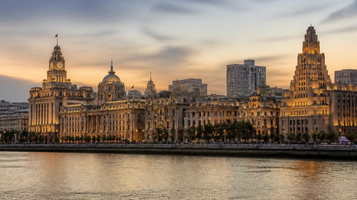
Most visitors photograph the Bund as a single object: a curved grey row with glass towers behind it. That is the postcard, and it is wrong in a useful way.
The row is not one thing. It is a construction record laid out in a line. Its buildings went up over roughly ninety years, commissioned by owners who had nothing in common except an address, in whichever style was fashionable in Europe at the moment each one was financed: neoclassical, Renaissance revival, Beaux-Arts, Art Deco, early modernism. Walk the mile from south to north and you are not looking at a skyline. You are reading dates.
Once you know that, the details stop being decoration and become evidence.
An embankment word and an outer bank
The two names for this place come from different languages, and neither translates the other.
Bund entered English from Hindustani, where it meant a dyke or embankment. In the Chinese treaty ports it narrowed to a specific sense: an embanked quay running along a shore. It was never a proper noun. Other treaty ports had bunds too; this one outlasted them in general use.
The Chinese name is unrelated in origin. It means outer bank, and it exists to distinguish this stretch from the inner bank further south, closer to the old walled city — the customary boundary ran near the Lujiabang creek. Before 1843 the whole thing was mudflat.
The geography is worth fixing in your head. The Bund proper runs from Yan’an Road in the south to the Waibaidu Bridge in the north, where Suzhou Creek joins the Huangpu. That is about 1.5 kilometres of frontage; the road itself, Zhongshan East First Road, is recorded at 1,108 metres. It was laid and the bank reinforced in 1848.
Three generations, not one style
This is the most useful thing to carry along the walk: it converts a wall of grey stone into a sequence.
Generation one, 1843 to the 1890s. Brick and timber, two or three storeys, either imitation English country style or the verandah-and-arcade form borrowed from British India. Jardine Matheson put up a two-storey house here in 1843, and by 1849 eleven firms had built in the same manner. From the 1860s these began to be replaced by Renaissance-revival rebuilds. Of that entire first wave, only the former British consulate survives.
Generation two, the 1890s to the 1910s. Land prices rose, cement arrived, and roughly half the frontage was rebuilt in reinforced concrete at three to six storeys, in an eclectic manner that mixed sources freely. The Palace Hotel of 1908, with Shanghai’s first lift, belongs here; about ten survivors of this wave stand today.
Generation three, the 1920s and 1930s. Eight storeys and up, steel frames, granite cladding, central heating and air conditioning, and a drift towards early modernism. This is the generation that produced the profile everyone photographs, and it is essentially finished by the end of the 1930s. Nothing significant was added to the river frontage for the next fifty years.
That last sentence is the point of the street. The Bund is a skyline with a closing date.
How many buildings? Pick a definition
Guides state a number confidently. There are at least three, and they conflict only if you ignore what each counts.
On 20 November 1996 the State Council listed the Shanghai Bund Architectural Complex in the fourth batch of Major Historical and Cultural Sites Protected at the National Level. That listing covers 27 buildings, from the Asia Building at 1 Zhongshan East First Road to the Astor House at 15 Huangpu Road, over a length given as 1.3 kilometres. That is the legally defined answer.
When the Bund tunnel was driven beneath the district between 2007 and 2010, the engineering brief named 33 municipally listed heritage buildings that could not be damaged, including several set back from the water. That is the working answer.
English-language accounts commonly say 52, counting the whole west frontage and its corners. Chinese-language accounts commonly say twenty-odd, counting only the river-facing row plus two modern insertions. Both are defensible.
One local habit is worth adopting: because tenants and building names changed constantly while street numbers did not, Shanghai residents identify these buildings by number. Number 3, number 12, number 18. Do the same and you will never name the wrong building.
Number 12: a dome that spent forty-one years under paint
The former HSBC Building occupies more ground and frontage than anything else on the street. Construction ran from 5 May 1921 to 23 June 1923, to a design by Palmer and Turner, with a floor area of 23,415 square metres. Contemporary publicity called it the most luxurious building between the Suez Canal and the Bering Strait, and the largest bank building in the Far East.
The interior is the reason to go in. Above the octagonal entrance hall sit eight mosaic murals, one for each city where the bank held a branch, with a ceiling carrying the twelve signs of the zodiac and figures of sun, moon and fortune.
Their survival is an odd story, and the sources agree on its shape. In 1956, ahead of the building’s use for receiving foreign guests, there were proposals to destroy the murals as too commercial and too Western. Chen Zhi, head of the municipal civil architecture design institute, argued instead that they be covered with paint, knowing the mosaic tesserae would not corrode underneath. The proposal was approved. The murals vanished for forty-one years — which is also how they escaped the Cultural Revolution — and were found again during renovation in November 1997. The Shanghai Pudong Development Bank funded the restoration and substituted its own emblem and a magnolia motif for the original crest, worth knowing before you photograph them as untouched.
The building served as HSBC’s Shanghai headquarters from 1923 to 1955, then as the municipal government building until 1995, and has housed the SPD Bank since. The bronze lions outside are replicas cast in 1997; the originals, removed in 1966, are in the Shanghai Museum. Even the lions carry a source conflict: English accounts credit a design by Henry Poole and casting by J W Singer and Sons in Frome, while Chinese accounts name William Wagstaff as sculptor and a Shanghai foundry. Do not repeat either as settled.
Number 13: the clock that changed its tune
Next door, the Custom House was completed on 19 December 1927, also by Palmer and Turner, at a cost of 4.3 million taels of silver, roughly twice its budget. It was the tallest building on the Bund when it opened, and it is still a working customs building — the rarest thing on this street, an occupant that never changed.
A yamen-style customs house with a ceremonial arch stood here after an 1857 rebuild; a Gothic design with a five-storey clock tower, chosen under Robert Hart, replaced it in 1891; that came down in 1925 for the present structure. Three buildings, one function, seventy years.
The tower rises 90 metres, and each of the four dials is 5.3 metres across, made of more than a hundred pieces of glass. The five bells, the largest weighing six tonnes, were cast by John Taylor of Loughborough and the movement built by J B Joyce and Company, both shipped from England in 1927 and both modelled on the Westminster clock.
What it plays is a small political history. The Westminster quarters gave way to The East Is Red during the Cultural Revolution. The original tune was restored in October 1986 for Queen Elizabeth II’s visit to Shanghai. In 1997, on the eve of the Hong Kong handover, the music was stopped and only the hour strike remained. In 2003 The East Is Red returned, though the mechanism cannot actually play it and what you hear is a recording over loudspeakers. Since around October 2018 the bells have not played tunes at all.
Numbers 20 and 23: an argument about one foot
These two buildings stand three doors apart and only make sense together.
Sassoon House, number 20, was built for Victor Sassoon between 1926 and 1929, again by Palmer and Turner, and it is the Bund’s Art Deco set piece: 77 metres to the roofline, 83 metres to the spire, ten storeys with Sassoon’s own penthouse on top, granite below and terracotta above, and a steep copper-clad pyramid roof now weathered green. The Cathay Hotel occupied floors four to nine. It became the Peace Hotel in 1956, reopened after renovation in 2010 as the Fairmont Peace Hotel, and its owner and operator announced in 2025 that it will be renamed again, as a Raffles property, on completion of further works in 2027.
Number 23 is the Bank of China Building, on the site of the old German Club, seized as enemy property during the First World War and sold to the bank for 630,000 silver yuan. In April 1934 the board approved an eighteen-floor building. The original design had reportedly called for thirty-four floors, which would have made it the tallest in the Far East, and the foundations were built strong enough for it.
Here the story splits, and both versions are in print. English sources say Sassoon insisted that nothing beside his building rise above his spire, that the Municipal Council refused the permit on the pretext that a thirty-four-storey structure would endanger neighbouring foundations, and that the finished building ended up one foot lower than Sassoon House. Chinese sources tell a version in which the dispute went to litigation in London and the outcome was seventeen floors, thirty centimetres below the pyramid. One foot and thirty centimetres are close enough to be the same anecdote told twice; seventeen and eighteen floors are not. Treat the rivalry as documented and the measurements as unsettled.
What is not disputed: the design was by Palmer and Turner with Luke Him Sau, the bank’s chief architect, and the building carries the only Chinese-style roof on the row. It topped out in 1937, war intervened, and the bank did not move in until 1946.
What the ledgers say about this street
The Bund’s function is easiest to describe in numbers, and the numbers do the work better than adjectives would.
The British settlement was established here from 1844, and the British and American settlements merged into the International Settlement in 1863. Foreign firms on the Bund numbered 61 in 1864 and 157 by 1875. The first Chinese-owned bank, the Imperial Bank of China, opened here in 1897, and in 1928 the central bank and the head offices of the Bank of China and the Bank of Communications all moved to this street.
By 1935, the Bund held 50.72 per cent of the paid-in capital of China’s banks, 61 per cent of cash reserves, 77.84 per cent of deposits and 77.64 per cent of loans. That is what a concentrated financial district looks like on a balance sheet.
It ended quickly. The settlements were returned in August 1943; after 1949 most of these buildings passed to state bodies, the banks moved out, and the street stopped being a financial centre for four decades. From 1995 a municipal property-exchange programme reversed that, moving government occupants out and commercial tenants back in.
You are standing on a flood defence
The promenade is the newest major structure on the Bund and the least often noticed.
Typhoon flooding repeatedly overtopped the riverbank, and the municipal response was a high levee along the waterfront. The decisive works came with the reconstruction begun on 18 April 1992 and substantially complete by January 1993, described at the time as the largest single rebuild of the Bund since the port opened. It pushed the embankment tens of metres into the river and put sightseeing, retail, parking and planting on the reclaimed strip.
Two consequences follow. The parkland that once ran between road and water is much thinner than in old photographs, because Zhongshan Road was widened as well. And you reach the water view by climbing, because the deck sits on the flood wall.
A social footnote: from the early 1970s, a thousand-metre stretch of the old flood wall between Huangpu Park and the Yan’an Road ferry landing was Shanghai’s best-known courting spot, the lovers’ wall, in a city with almost no private space. A flood defence then too.
The decade the road went underground
Between 2007 and 2010 the Bund was rebuilt around one decision: move through traffic below the ground it was ruining.
The Bund tunnel runs 3,315 metres from Zhongshan South Road to Haining Road, opened on 28 March 2010 after 33 months of work, and carries six lanes on two decks north of Yan’an East Road and four south of it. Above it, the surface road dropped to four lanes and the reclaimed width went to the promenade.
The constraints are the interesting part. The northern section was driven with a 14.27-metre earth-pressure-balance shield, the largest then in the country, passing under the Waibaidu Bridge, two road underpasses and Metro Line 2 — with just 1.46 metres between the top of the metro tunnel and the bottom of the shield, and as little as 1.7 metres from the foundations of the Astor House. Thirty-three protected buildings had to come through undamaged.
Two removals came with it. The elevated ramp locally nicknamed Asia’s first bend, where the Yan’an Road expressway dropped onto the Bund, went in 2008. The Waibaidu Bridge, in place since 1908, was floated away for a year of restoration in the same year and returned. The tunnel took roughly 70 per cent of through traffic off the surface.
After 2014: why the stairs are one-way
On 31 December 2014, shortly before midnight, a crush on the steps between Chen Yi Square and the viewing platform killed 36 people and injured 49, thirteen seriously. The official investigation of 21 January 2015 estimated about 310,000 people in the Bund area at the time.
The findings were procedural rather than dramatic, which is why they still shape your visit. The New Year light show had been moved that year from Chen Yi Square to Rockbund, half a kilometre north, to reduce traffic pressure — and the change was not communicated in time. People arrived where the show had been in previous years. Upward and downward flows met on the same staircase, jammed, then surged. Policing for the whole Bund and Nanjing Road that night amounted to 350 police officers, 108 urban-management staff and 100 armed police. Eleven officials were disciplined.
The practical legacy is a set of tools the city now uses without announcement: staircases run one-way on peak dates, the promenade can be capacity-limited, and East Nanjing Road station is closed to boarding and alighting on major holidays purely to throttle arrivals. None of it is published as a fixed schedule. On a public holiday, assume management, check the day’s notices, and do not plan on the route you used last time.
Stand at number 12 and look south: the buildings get lower and older. Look north and they get taller and later, until the wall stops in the 1930s and the towers across the water pick the story up sixty years on. That gap is the real subject here, and the best place to see both halves at once is from the middle of the river — the subject of our Huangpu River cruise guide.
The LoreLens app can identify individual Bund buildings from a photograph and explain their construction dates, original owners and current uses on the spot.
Location profile
Where it is

Frequently asked questions
How many buildings are actually on the Bund?
It depends entirely on which line you draw, and the honest answer is that three different numbers are all correct. The State Council listing of 1996 covers 27 buildings, running from the Asia Building at 1 Zhongshan East First Road to the Astor House at 15 Huangpu Road, a stretch given as 1.3 kilometres. The Bund tunnel project of 2007 to 2010 worked to a protection list of 33 heritage-listed structures along its alignment, a wider net that includes buildings set back from the water. English-language accounts most often say 52, counting the full frontage plus adjoining corners. Chinese-language accounts frequently say twenty-odd, counting only the river-facing row. None of these is wrong; they answer different questions. If a guide gives you one number with no definition attached, that is the tell.
Can you go inside the buildings?
Some, and the rule of thumb is that working institutions are more accessible than you expect. The banking hall at number 12, with the restored dome mosaics above the octagonal entrance, is a functioning branch of the Shanghai Pudong Development Bank and is generally enterable during business hours, though photography rules are set by the bank and are enforced. The Peace Hotel at number 20 is a hotel: the lobby, bar and Art Deco detailing are open to customers. Number 18 and several neighbours have been converted to shops and restaurants. The Custom House at number 13 remains a customs building and is not a visitor attraction; the clock tower is not open to the public. Access conditions change with tenancy, so treat any list, including this one, as a starting point rather than a guarantee.
Why is the promenade so much higher than the road?
Because it is not a promenade first. It is the top of a flood defence. Repeated typhoon-driven floods pushed the municipal government to build a tall levee along the waterfront, and the major reconstruction begun on 18 April 1992 and substantially finished by January 1993 pushed the embankment tens of metres out into the river and raised the viewing deck onto it. That is why you climb steps to reach the water view, why the historic parkland between road and river is so much thinner than old photographs show, and why the 1970s courting spot known as the lovers' wall ran along a concrete parapet rather than a garden path. The height is engineering; the view is a by-product.
When is the best time to go, and are there crowd restrictions?
Early morning is the least managed hour and the only time the promenade is genuinely quiet. Evening is when the facade lighting on both banks is on, and it is also the most crowded. Since the stairway crush at Chen Yi Square on 31 December 2014, which killed 36 people and injured 49, Shanghai has treated the Bund as a managed crowd space on peak dates: staircases can be run one-way, the promenade can be capacity-limited, and East Nanjing Road metro station is closed to boarding and alighting on major holidays as a flow-control measure. None of this is on a fixed published timetable. Check the day's notices before travelling on a public holiday, and assume the route you took last time may be reversed.
Sources and further reading
Background references for the history and place names in this guide. Opening hours, ticketing and access change often — always confirm with official local information before travelling.