Shanghai
The Huangpu River Cruise: Sixty Years Across the Water
A boat between two bridges crosses one river and two eras. The west bank stopped growing in the 1930s, the east bank started in 1990, and the working channel between them still carries the traffic that made both of them possible.
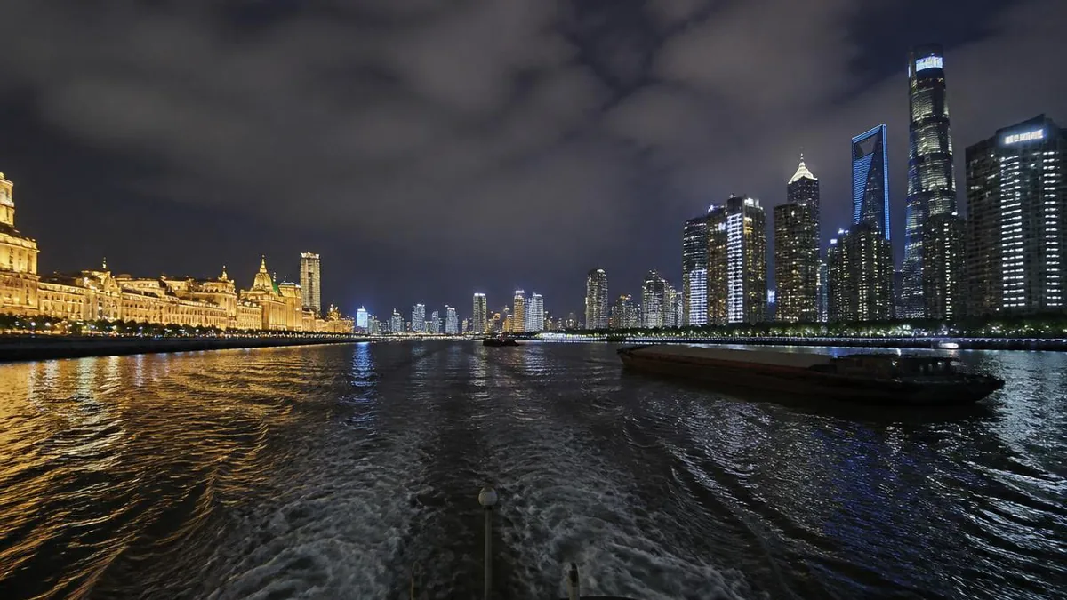
The Bund tells you what Shanghai built before the war. Lujiazui tells you what it built after 1990. Neither bank can show you the other, and that is the entire argument for getting on a boat.
The Huangpu is not scenery with a city attached. It is the dividing line the city is defined against — Puxi means west of the Huangpu, Pudong means east of it — and it is also the timeline. On one side, a stone frontage that was essentially complete by the end of the 1930s. On the other, towers that did not exist when people alive today were adults. Sail the middle and you get a compressed urban history in one journey, plus a working harbour that neither promenade lets you see.
The two banks are sixty years apart
Start with the gap, because everything else on the water is a footnote to it.
The west bank stopped growing early. The financial district on the Bund had reached its final profile by the end of the 1930s, and nothing significant was added to that frontage for the next fifty years.
The east bank effectively did not exist as a skyline. Before 1990, Pudong accounted for about 8 per cent of Shanghai’s economy, and the local saying was that a bed in Puxi beat a room in Pudong. On 18 April 1990 the central government announced the decision to develop and open Pudong, and the Lujiazui Finance and Trade Zone became the country’s first national-level financial development zone. Core Lujiazui — the loop the river makes around the point — covers about 1.7 square kilometres.
So the cluster you photograph from the Bund is, almost entirely, younger than 1990. The Oriental Pearl tower began piling in 1991 and opened to visitors on 1 May 1995; the taller towers behind it came later still. Thirty-odd years of construction stands opposite ninety years that ended before it started.
The river that took another river’s job
The Huangpu was not always the main channel, and the reversal is documented.
Historically the Wusong River — known in the city as Suzhou Creek — was the principal drainage of the Taihu basin to the sea, and the Huangpu was its tributary. By the early Ming the lower Wusong had silted so badly it was becoming land. In the Yongle era the official Xia Yuanji was sent to fix the flooding, and his solution diverted the Taihu outflow north through other channels while leading the Huangpu into the Fanjiabang and out at Wusongkou.
The result is called the Huangpu capturing the Wusong. Afterwards the Wusongkou mouth belonged to the Huangpu, and Suzhou Creek became the Huangpu’s largest tributary rather than the other way round. You pass the junction at the north end of the Bund, under the Waibaidu Bridge.
The rest of the hydrology is worth carrying. Length is given as about 113 to 114 kilometres; width runs 300 to 700 metres, with roughly 400 in the city; the urban channel is around 10 metres deep and up to 17 at its deepest. About 78 per cent of Taihu’s runoff to the sea now leaves through this river, which is why Shanghai calls it the mother river and why a source marker stands far upstream on Longwang Mountain in Anji.
Where you board, and why that changed
The wharves have a history of their own, and it is mostly a history of being moved.
Shiliupu, on the west bank at the southern end of the Bund, is the old one. The name comes from the 1860s, when the walled city organised its merchants into sixteen wards for security and public affairs; this was the largest of them. The wards were abolished in 1909 but the name stuck to the waterfront. By the Jiaqing and Daoguang reigns this was already the hinge of the coastal sand-junk trade, with thousands of junks moored from here south, and by 1947 the district had 48 wharves large and small.
Its passenger business survived into living memory. Shiliupu was the way out of Shanghai by water — the terminal where Wenzhou traders queued for tickets through the 1980s — until road, rail and air took the traffic. The passenger terminal ran until September 2003, was demolished in December 2004, and the site was rebuilt as a waterborne tourism hub. That is the whole arc of this river in one address: cargo, then passengers, then sightseeing.
North of Suzhou Creek, the Hongkou waterfront carries the newer facilities, including the Shanghai Port International Cruise Terminal, begun in 2004, first berthing a cruise ship in July 2006 and fully operational by July 2009.
Which wharf your ticket uses is an operational question, not a permanent fact. Confirm it on the day.
The reach between two bridges
The sightseeing run works the central reach, and the two bridges that bracket it are worth knowing as objects rather than markers.
The Nanpu Bridge, upstream, was the first bridge across the river in the city centre and a starting project of the Pudong development. Construction began on 15 December 1988 and it opened on 1 December 1991: total length 8,629 metres, main span 423 metres, and — the number that matters from a deck — 46 metres of navigational clearance, enough for 50,000-tonne ships.
The Yangpu Bridge, downstream, opened on 23 October 1993 with spans of 243, 602 and 243 metres. That 602-metre main span was the longest of any cable-stayed bridge in the world until the Pont de Normandie took the record in 1995.
Yangpu is also a hard ceiling. Large cruise ships cannot pass beneath it, which is exactly why Shanghai built a separate cruise port downstream at Wusongkou, where the Huangpu meets the Yangtze — construction from December 2008, opening in 2011, first phase complete at the end of 2013.
Between those two bridges sit the Bund, Lujiazui, the old wharf frontages and the reopened public riverbanks. Operators vary on turning points and duration, and river traffic varies more, so treat any stated itinerary as provisional.
What only the channel shows you
This is the part the night-cruise marketing leaves out, and it is the best reason to go by day.
From a promenade, the river is a surface. From the middle of it, it is a workspace. You get tugs pushing barge trains, dredgers, inland container feeders, mooring buoys, the working faces of wharves that read as blank walls from land, and the pilot’s problem of a channel a few hundred metres wide with cross-traffic in it. You also feel the width change: the river swings hard around the Lujiazui point, and the same 400-odd metres feels very different on a straight than on the bend.
Two details reward attention. The bridges look thin from the shore and heavy from beneath, because you finally see the deck as a structure rather than a line. And the barges sit far lower in the water than you expect — inland cargo here is bulk, not boxes, and a loaded one has almost no freeboard left.
The banks themselves have been rebuilt for looking at, which is recent. The east-bank public waterfront opened continuously at the end of 2017, with a rest pavilion roughly every kilometre, and on 1 January 2018 the full 45 kilometres of both banks between the Yangpu and Xupu bridges opened to the public as continuous public space. What you see from the boat is a shoreline that stopped being industrial within the last decade.
And you see the ferries, which is the next section, because they carry a story the cruise boats do not.
The ferries, and a foggy morning in 1987
The cross-river ferry is older than every bridge and tunnel here, and it is still running.
Municipal ferry service on the Huangpu dates to 1911 — the sources give both 5 and 15 January for the first sailing, which is a small warning about precision in this material. By 1935 there were six routes and twelve boats. At its peak in 1993 the system ran 21 routes and about one million passengers a day, with a recorded high of 1.1 million; by 2011, after the bridges and tunnels, it was around 250,000 a day on 18 routes. It is public transport, priced as public transport, and it is the cheapest way to be on this river.
It also carries the river’s own crowd disaster, which is worth stating precisely because it is so often left out. On the morning of 10 December 1987, fog halted the ferries and passengers piled up at the Lujiazui landing. When service resumed at nine, the second boat drew a crowd already late for work. A man fell with his bicycle, others fell over him, and within about five minutes 17 people were dead, with two seriously and more than seventy lightly injured. Some accounts give a far higher figure; the official count is 17.
That is one of two crushes in this city’s riverside history. The other, on the Bund promenade on the last night of 2014, is covered in our Bund guide. Both happened where a crowd met a bottleneck at a fixed hour, and both are the reason Shanghai now manages riverside crowds on peak dates without announcing it.
Looking up at the towers instead of across at them
You will pass the Lujiazui cluster twice, and the view from the water is genuinely different from the view from the opposite bank.
From the Bund, the towers compose into a flat postcard: the pearl on the left, the taller three behind. From the channel, you lose that composition and gain a section drawing. The towers separate, their bases appear — the podiums, the ferry terminal, the promenade wall — and the foreshortening flattens the height difference that the Bund view exaggerates. It is a worse photograph and a better explanation of how the district is put together.
One thing is worth knowing about the tower everyone points at. The Oriental Pearl was not designed as a viewpoint. It was commissioned because Shanghai’s high-rise growth in the 1980s was creating shadow zones for the old 210-metre transmitter, and it was sized for broadcast coverage: a final height of 468 metres giving a television and FM radio radius of about 80 kilometres. Piling began on 30 July 1991, the structure was complete on 18 November 1994, and it opened on 1 May 1995. The observation decks are a business that grew on an antenna.
We cover the tower itself separately. From the water, treat it as a date stamp: everything around it postdates 1990.
The lights are a system, not a mood
Evening cruises exist because both banks are floodlit, and it is worth knowing that this is administered rather than ambient.
Facade and landscape lighting on the Bund and in Lujiazui is centrally controlled and runs to scheduled hours. Those hours are not the same every night: ordinary weekdays, weekends and public holidays are lit differently, and special programmes appear on particular dates and not others. Suzhou Creek’s own riverside lighting was switched on in stages from December 2021 and January 2022, so even the supporting cast has a commissioning date.
There is a specific precedent for the big set pieces. In 2012 and 2013, projection shows were staged on New Year’s Eve directly onto the facades of the former HSBC Building and the Custom House on the Bund. In 2014 the show was moved north to Rockbund, with consequences described in our Bund guide.
The practical instruction is short. Do not plan an evening sailing around a lighting schedule you read anywhere in advance, including here. Check the day’s notice, and if the lights matter more to you than the river does, book late rather than early.
The port that left
The last thing to understand from the deck is that you are sightseeing in a harbour whose cargo has gone.
Shanghai became China’s largest port soon after 1843. Between 1925 and 1933, 55 per cent of the value of China’s foreign trade moved through it; by 1936 it ran more than a hundred shipping routes and was East Asia’s shipping centre. All of that happened on the river you are sitting in.
Then the ships outgrew it. The Huangpu is a river port, and it could not take modern container vessels. Deep-water berths at Waigaoqiao on the Yangtze bank followed in 1995 at 10 to 11 metres, but the estuary channel was only about 7 metres and ships had to wait for the tide. The answer was to leave the river entirely: Yangshan, built on reclaimed islands in Hangzhou Bay and linked to Pudong by the 32.5-kilometre Donghai Bridge, opened on 10 December 2005 and handled 7,558 containers on its first day.
The result is a container port that has ranked first in the world since 2010, with 49.16 million TEU in 2023 and the fiftieth million container of the year handled on 22 December 2024 — and almost none of it within sight of your boat. The upstream reach still works: 3,000-tonne coasters run below the Songpu Bridge and larger vessels reach specific terminals. But the deep-sea trade left, and what remains in the centre is inland traffic, ferries, and you.
One journey, two clocks
Come back to the gap you started with, because the last twenty minutes of the return leg is the only time you can hold both halves at once.
On your left going upstream, a stone catalogue built between the 1840s and the 1930s by owners settling accounts in a treaty port, closed off by war and then by policy for fifty years. On your right, a financial district begun in 1990 on ground that was warehouses, shipyards and mud. Between them, a channel that changed course under an official’s flood plan six hundred years ago and now carries the drainage of a lake basin, a public transport ferry network, and a great many sightseeing boats.
The best sequence is to walk the west bank first, so you know what the buildings are, then take the boat, so you can see when they stopped. The Bund guide covers the first half.
The LoreLens app can identify bridges, towers and waterfront buildings from the deck and explain their dates and functions as you pass them.
Location profile
Where it is

Frequently asked questions
Which stretch of the river does a sightseeing cruise actually cover?
The standard central-city run works the reach between the Nanpu Bridge upstream and the Yangpu Bridge downstream, with the Bund and Lujiazui roughly in the middle, and turns back at or near one of them. That is the reach where the historic waterfront, the financial district and the reopened public riverbanks all sit within a few kilometres of each other. Beyond it the river stops being scenic and becomes industrial in both directions. The Yangpu Bridge is also a real physical ceiling rather than a scenic choice: its clearance is the reason large cruise ships cannot reach the passenger terminal in Hongkou and berth downstream at Wusongkou instead. Operators differ on exact turning points, duration and whether the outbound and return legs follow the same bank, and all of it changes with river traffic and water level, so confirm the actual route on the day rather than from any published diagram, including this description.
Is a night cruise worth it, or is daytime better?
They show you different things and it is fair to say so plainly. At night you get the facade lighting on both banks, which is the reason most people book, and almost nothing else: the working river disappears, the container barges become navigation lights, and the bridges read as outlines. By day you see what the piece is really about — tugs, dredgers, barge trains, ferries crossing your bow, wharf structures, the reopened public promenades and the actual difference in age between the two banks. Lighting on the Bund and Lujiazui is centrally controlled, runs on scheduled hours, and differs between ordinary evenings, weekends and public holidays, with extended or special programmes on some dates and none on others. There is no reliable year-round timetable to quote, so check the day's announcement before you buy an evening ticket.
Where do the boats leave from?
Several wharves along the central reach, and which one you use depends on the operator and the sailing. The Shiliupu wharf on the west bank, at the southern end of the Bund, is the historic passenger landing: it handled coastal and river services until September 2003, was demolished in December 2004 and rebuilt as a waterborne tourism hub. Other departures use wharves along the Hongkou waterfront north of Suzhou Creek, including the area around the Shanghai Port International Cruise Terminal, which began construction in 2004, received its first cruise ship in July 2006 and was fully operational by July 2009. Tickets, sailing times and the wharf printed on them all move by season and by day. Buy from the operator or an official channel and confirm the departure point on the day, because the pier named in older guides may no longer be the one you board from.
How is a cruise different from just taking the ferry?
The ferry is transport, and that is exactly its value. Shanghai Ferry has operated on the Huangpu since 1911, once carried over a million passengers on its busiest days in 1993, and still runs roughly eighteen cross-river routes as part of the public transport system, at public transport fares. It crosses the river rather than running along it, so you get a few minutes broadside to the current, a working deck, commuters and bicycles, and a view of both banks from water level with no commentary. A sightseeing cruise runs the length of the reach, which is the only way to see the whole sequence of bridges, wharves and skyline in order. Doing both costs very little: take the ferry once by day for the texture, and a cruise once for the sequence.
Sources and further reading
Background references for the history and place names in this guide. Opening hours, ticketing and access change often — always confirm with official local information before travelling.