Zhejiang · Taizhou
Taizhou Prefectural City: The Wall That Is Still Load-Bearing
Most old Chinese city walls are monuments. This one is still equipment. When a typhoon comes up the Ling River, crews pack the gate openings of Linhai's Ming wall with sandbags — around 120,000 of them in one recent operation — and the fourteen-hundred-year-old flood defence goes back on duty.
5A View location, maps and nearby scenic areasOn 10 August 2019, at three in the afternoon, the Ling River came over into the old city of Linhai. Typhoon Lekima had stalled over eastern Zhejiang; the river ran hard past the foot of the ramparts, found the gate openings, and put about a metre and a half of water through the streets of a prefectural capital that had spent sixteen hundred years arranging itself not to flood.
Since then the drill has been rehearsed and improved. When a typhoon is forecast now, trucks bring sandbags to the riverside gates and crews wall them up — roughly 120,000 sandbags in one recent operation, packed into the archways of a Ming wall, with the city dry behind them.
That is the thing to understand about Taizhou Prefectural City before you understand anything else. Almost every famous city wall in China is a monument: a preserved object with a walkway on top and a ticket office at the bottom. This one is a monument and a working piece of municipal flood infrastructure at the same time, and the second function is the reason the first one still exists.
What is actually inside the 5A
The scenic area is called Taizhou Prefectural City Cultural Tourism Area, and the first confusion to clear up is geographic. It is not in the city that is called Taizhou today. Taizhou prefecture moved its administrative seat to the coast — to Jiaojiang, about fifty kilometres east — in the early 1990s. The prefectural city itself, the walled town that was the seat for something close to fourteen centuries, is Linhai, now a county-level city under Taizhou. Chinese visitors say Linhai; the signage says Taizhou Prefectural City; both mean the same square kilometre of old streets.
The Ministry of Culture and Tourism closed its public notice period on 12 July 2022 and published the announcement on 15 July 2022, naming twelve new 5A areas. Taizhou Prefectural City was second on the list, after the Hukou Waterfall on the Yellow River. It was Zhejiang’s twentieth 5A. The whole site had been working towards the rating since 2016, and it marked the award by opening free to all visitors for the month of July.
Total area: 3.12 square kilometres. That is small — the Wuzhong Lake Tai 5A across the provincial border in Suzhou is nearly seven times larger and takes three separate days — and the compactness is the best practical thing about this designation. Everything inside it is walkable.
What is inside it is where the sources start to drift. The most common formulation names four core components: the prefectural city wall, Ziyang Street, East Lake and Jin Hill. An equally common formulation names five, adding Longxing Temple. Municipal and provincial write-ups use both, sometimes in the same week. The honest reading is that the four-part list is the administrative core and the five-part list is the visitor’s experience, because Longxing Temple sits at the western foot of Jin Hill and you will walk past it whether or not a document says you are inside the boundary.
What is not inside it
Two things get attached to this 5A that do not belong to it, and both cost real driving time.
The first is Taohu, an old coastal garrison fort about forty kilometres east of Linhai, near the sea. It is separately protected at national level, it is genuinely worth a half-day, and it is directly relevant to the story of this wall — Chinese accounts credit Taohu, not the prefectural city, as the place where the hollow enemy platform was first built. But it is not in the 5A and it is not on the ticket.
The second is the rest of Taizhou prefecture. Mount Tiantai, with Guoqing Temple and the Tiantai Buddhist school, is a separate 5A about seventy kilometres northwest. Shenxianju, the rhyolite gorge with the curling glass bridge, is a separate 5A about eighty kilometres west. Both are excellent, both are commonly bundled into the same itinerary, and neither shares a ticket, a gate or an administration with this one.
The wall that survived by being a dam
The received chronology is compact enough to quote in one line, and you will see it on every panel: founded in the Eastern Jin, extended under the Tang, given its form under the Song, completed under the Ming and Qing.
The founding event is dated to 402 CE, when the prefect Xin Jing threw up an inner fortification on Dagu Hill against the rebel armies of Sun En — a Daoist-led rising that convulsed the southeast coast at the very end of the fourth century and which, at its height, moved by sea. That first work was a citadel, not the circuit you walk today. The Tang extended it. The Northern Song rebuilt it in the Dazhong Xiangfu reign period, between 1008 and 1016, and it is essentially the Song circuit that later dynasties inherited.
Then comes the fact that explains everything else. The Yuan rulers, having conquered the south, ordered city walls demolished across the country so that no walled town could be held against them. Taizhou’s wall was exempted. The reason recorded in the local sources is not sentiment or negotiation: the wall was the town’s flood defence against the Ling River, and pulling it down would have drowned the place. A military structure survived a demolition order by being, demonstrably, a piece of hydraulic engineering.
The Qing added the last major element. In the fifty-first year of the Kangxi reign — 1712 — barbicans were built at the gates, the enclosed forecourts that trap an attacker between two sets of doors. Four of them survive.
Two more dates finish the paperwork. The wall was listed as a national key protected cultural relic in 2001. In 2012 it was written into China’s World Heritage tentative list as part of the serial nomination Ming and Qing City Walls of China, which began with four walls — Nanjing, Xi’an, Jingzhou and Xingcheng — and expanded that April to include Linhai, Shouxian, Fengyang, Xiangyang and others. The nomination has since grown to over a dozen walls and has been running for more than a decade without an inscription, which is why the people who work on it locally describe it as a long-distance race rather than an application.
Four things this wall did first
Luo Zhewen’s endorsement — the one on every sign here — is not vague praise. It rests on four specific construction features, and the local case is that all four were done here first or done here uniquely.
Full brick and stone facing. Chinese city walls were rammed earth with masonry applied where it showed. Here the rammed core was faced in brick and stone on both sides, over the whole circuit. Local accounts claim this as a national first.
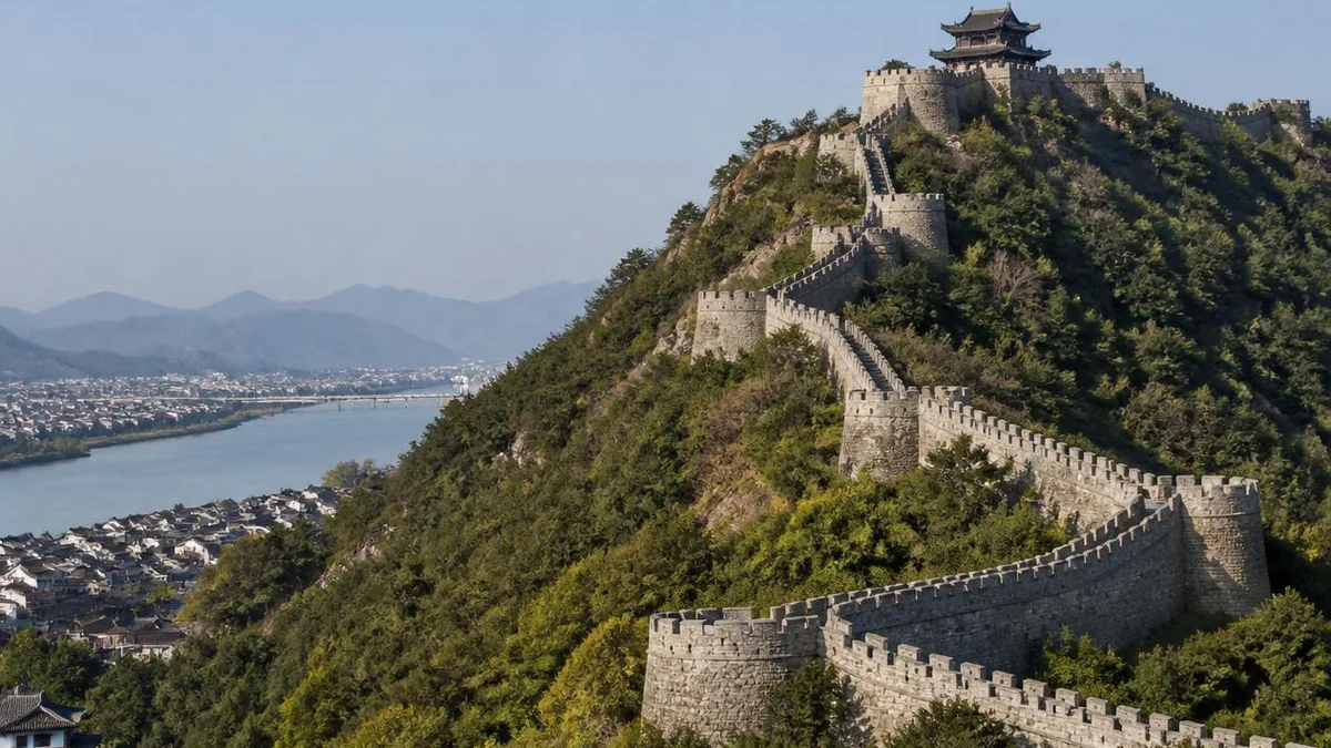
Curved horse-faces. A mamian, literally horse-face, is the rectangular bastion that projects from a wall so defenders can shoot along its base. Every other Chinese wall builds them square. On the river-facing stretches here they are built as half-arcs — a curved nose presented to the current, so that flood water and the backwash of the East China Sea tide split around them instead of hammering a flat face. This is described in the Chinese literature as unique in the country, and it is the single most photographable expression of the wall’s double life: the same bastion is a firing position pointed at people and a bridge pier pointed at water.
The double-decked hollow enemy platform. Standard practice was a solid tower. A hollow platform is a two-storey chamber straddling the wall, windowed on all four sides, in which soldiers can live, sleep and store weapons and powder rather than climbing up to a bare firing step in the rain. Thirteen were planned and built into this circuit. It is the innovation that travelled.
The skylight in the gate tunnel. Several of the gate structures have an open shaft, like a light well, in the roof of the passage. Nobody is certain what it was for. The most-repeated guess is that it was a hoist for getting weapons and ammunition up to the wall top without going round; you will also read that it was for light, for smoke, or for pouring things on people underneath. The honest answer available at present is that its function is unclear.
The general who took the design north
Qi Jiguang (1528–1588) is the name this town trades on, and for once the trading is proportionate. He is the standard Chinese emblem of the competent professional soldier — the man who solved a problem that had defeated everyone else — and the problem was wokou, the mixed Japanese and Chinese pirate bands that were tearing up the Zhejiang and Fujian coast in the middle of the sixteenth century.
Posted to Taizhou as a regional vice-commander, he concluded that the coastal garrison troops were unusable and in 1559 went inland to Yiwu to recruit miners: men who fought each other over ore, and who were, he thought, correctable into soldiers. The force he built out of them became known as the Qi Family Army. For them he devised the mandarin duck formation, a squad of eleven — a leader, two shieldmen, two men on the langxian, two spears, two on the three-pronged tangpa — in which long and short weapons and offence and defence were locked together so that no individual swordsman, however good, could get inside it. The langxian itself is the giveaway detail: a whole length of moso bamboo, side branches left on and sharpened, a weapon made from what grows on the hills behind the town.
In the fourth and fifth months of 1561, the fortieth year of the Jiajing reign, he fought a rolling campaign around Taizhou — Ninghai, Xinhe, Huajie, Shangfengling, Chumen, Aiwan Bay, Tengling, Changsha — and won every engagement. Chinese military history knows it as the Taizhou victory or, more commonly, nine battles, nine victories. The Huajie engagement was fought effectively at the city’s doorstep.
In 1568 he was appointed regional commander of the Ji garrison, the sector of the northern frontier covering the approaches to Beijing, and stayed sixteen years, until 1583. What he did there was rebuild the Ming Great Wall on the model of the wall he had just left: face it fully in brick, and replace the solid towers with hollow, wall-straddling chambers his men could live in. This is the basis of Luo Zhewen’s judgement that the wall at Linhai is the model and the blueprint of the northern Ming Great Wall — and, downstream of that, of the tourist-board nickname Jiangnan Great Wall, which is doing the causation backwards but is not making the relationship up.
Of the thirteen hollow platforms built into this circuit, local sources say eight survive.
How long is it? Depends who you ask
This is a case where the published numbers do not agree and no amount of reading resolves them, so here they are side by side.
- Full historic circuit: 6,286 metres in the more precise accounts; over 6,000 metres in the looser ones; occasionally 6,280.
- Surviving today: 4,730 metres in municipal and heritage write-ups; over 5,000 metres in most tourism copy.
- Surviving structures: five gates, four barbicans, eight enemy platforms, thirteen beacon platforms.
The gap between 4,730 and over 5,000 is not rounding. The eastern stretch of the wall was pulled down in 1956, and the lower figure is the one that reflects it. Where a site’s own marketing and its own conservation office publish different lengths, the conservation office is usually counting and the marketing is usually quoting something older.
There is a second small ambiguity in the tally above. Thirteen appears twice in the literature — thirteen hollow platforms built by Qi Jiguang, of which eight survive; and thirteen beacon platforms standing today. They are not the same thirteen, and write-ups that copy from each other frequently collapse them into one number.
The gates are worth reading rather than counting. The three that face the river south of the town were named as instructions: Zhenning, calm and quiet; Xingshan, do much good; Jingyue, pacify the Yue lands — a gate named for the subjugation of the region it stands in. Two others, Fengtai and Kuocang, are gone. Lansheng, the tourist entrance at the eastern end, and Wangjiang, facing the water, were opened later.
Walking the wall
Start at Lansheng Gate, at the eastern end, because that is where the climb is.
The archway in front of it carries four characters on the outer face — mighty garrison of the southeast — and four more on the reverse, roughly the glory of a thousand ages. Behind it the staircase goes up the flank of Beigu Hill in a single unbroken flight that the locals call the Hundred Step Steep and that visitors count at 198 steps. It is the hardest ten minutes of the day and it is over quickly.
At the top is the gate tower, named Gujing Lou, the pavilion for looking back at the view. From here the wall runs west along the spine of Beigu Hill: Baiyun Lou, the highest point of the eastern section; the round platform locally known as the sky-watching terrace; and Yanxia Pavilion, where the ridge ends and the wall drops through steep rock to the east bank of the Ling River, then runs on to the western foot of Jin Hill.
This northern stretch is the section that gets photographed and it is the reason for the Great Wall comparison: a brick parapet following a ridgeline through green hills, with the mountains of eastern Zhejiang behind and a wide slow river in front. It looks, from certain angles, exactly like the postcard from Badaling, at about one-fiftieth of the crowd.
One more thing about the wall that has no northern parallel. From the Northern Song, the prefecture kept a standing corps of soldiers whose entire job was maintaining the masonry — the zhuangcheng bing, the wall-strengthening troops, a hundred men on establishment, raised to a hundred and fifty under the Southern Song. Chinese accounts describe this as exceptional; walls were normally repaired by conscripted labour after they failed. A town that budgeted permanent staff for pointing and patching is a town that had understood the river.
Ziyang Street, and the man it is named after
Inside the walls, the spine of the old town is Ziyang Street: 1,080 metres north to south, four to five metres wide, stone-paved, lined with shopfronts — pharmacies, dye works, teahouses, wine shops, several of them century-old firms — and, in the evening, one of the better snack streets in Zhejiang. In 2012 it was named in the fourth round of China’s Historic and Cultural Streets, the second street in Zhejiang to make that list after Hangzhou’s Qinghefang.
The feature to look for is architectural rather than commercial. At intervals along the street stand tall grey-brick ward walls pierced by an archway, each one carrying a name plaque. These are the surviving markers of the old ward system — the fang into which a Chinese city was administratively divided — and they had a second, blunter function: they are firebreaks, brick barriers across a street of timber shophouses, designed so that a fire in one block stops at the wall. The Republican-era Linhai County Gazetteer records fourteen wards in the town in the Jiading reign period of the Southern Song, 1208 to 1221. Five of the gates stand on this street, named from south to north Yongjing, Qinghe, Yingxian, Fengxian and Wuzhen.
That last name is the street’s own footnote. Wuzhen — awakening to reality — is the title of the Wuzhen pian, the foundational text of Daoist internal alchemy written in the 1070s by Zhang Boduan, honoured as the Perfected Man Ziyang and reckoned the founder of the Southern Lineage of the internal-alchemy tradition. The street is named after him.
Whether he was from here is disputed. Most reference works record him as a man of Tiantai, the county up the road. Linhai claims him, and there is a genuine, still-running Chinese scholarly argument on the question, complete with published rebuttals in both directions; his birth and death years are contested in the same literature, with 984 and 987 both in circulation against a death in 1082. The street took its present name only in the 1990s. What is not disputed is that the ward gate at the north end has been called Wuzhen for a very long time, and that whoever named it had read the book.
The lake that exists because the wall moved
East Lake is a made thing, and the reason it was made is the same reason the wall was spared.
In 1071 — the fourth year of the Xining reign — the prefect Qian Xuan dealt with the town’s flooding problem by pulling the eastern city wall inward and having the ground outside the new line dug out into a lake. The excavation gave the town a flood basin, a boating water and, incidentally, a garden. Qian had a cross-dyke built to divide it into a front and a back lake, and put up a hall, a winding-cup pavilion for drinking games, and a temple. He wrote a poem for the hall, which is the sort of thing a Song prefect did.
Today the lake covers about 280 mu, something under twenty hectares, and is laid out in three areas — the eastern shore, the lake centre and the back lake. The back lake is a small Suzhou-style garden with a covered bridge, water on three sides and a rockery, and it reads exactly as intended: a private Jiangnan garden in miniature. In the centre, reached over a nine-bend bridge, stand the lake-heart pavilion — octagonal, three storeys, about 129 square metres of footprint, with a gourd finial — and Qiaoyun Ge, the tallest building on the water and the place to climb for the view.
Two things here reward a slow half-hour. The first is the shrine to Luo Linhai, in the middle of the lake: a memorial hall to Luo Binwang (c. 619–684), one of the Four Paragons of the Early Tang and one of the more combustible figures in Chinese literary history, who served as assistant magistrate of Linhai — hence the name the shrine uses — and who later wrote the public denunciation of the Empress Wu Zetian that is still taught as a model of invective.
The second is the stele forest, more than a hundred carved stones from various dynasties. Among them are a portrait stele of Tan Lun (1520–1577), the official who governed here and who was Qi Jiguang’s patron and superior through the pirate wars, and a stele recording Qi Jiguang’s merits. Whatever else this lake is, it is also the local war memorial.
The Qing scholar Yu Yue (1821–1907) is quoted on a wall here to the effect that Hangzhou has its West Lake, Taizhou has its East Lake, and East Lake is a small West Lake. Treat that as a plaque quotation rather than a citation. It is, in any case, roughly the right size of claim.
One hill, four pagodas
Jin Hill — Kerchief Hill — is Linhai’s emblem and the southern anchor of the walk. According to tradition it is where the Perfected Man Huanghua ascended to heaven, dropping his headcloth, which turned into the hill. It sits on what Zhejiang tourism calls the Tang Poetry Road of the eastern province, the itinerary of scenic points that Tang poets actually visited and wrote up.
What makes it unusual is the skyline: four pagodas on one hill, protected together at national level as the Jin Hill pagoda group.
- The twin pagodas stand on the hill’s two peaks — the Great and Lesser Wenfeng pagodas, east and west. Founded in the Tang, both are five storeys and hexagonal, with corbelled brick courses stepping out under each eave.
- The Nanshan Hall pagoda, on the southwestern flank, is Ming, and closely follows the form of the other two.
- The Thousand Buddha Pagoda, at the western foot, is the interesting one. The surviving structure was rebuilt in 1299, the third year of the Dade reign of the Yuan, in mixed brick and timber. Its outer faces are set with 1,003 moulded Buddha bricks, which is where the name comes from. It is described as the only surviving Yuan pagoda in Taizhou, and, in the wider claim, one of only two left in Zhejiang.
A hill with four pagodas of three different dynasties on it is rare enough in China that the phrase one hill, four pagodas functions locally as a slogan. At the foot of the hill, on the square, a municipal folk museum covers the building history of the prefectural city, which is a useful forty minutes if you want the chronology laid out before you walk the wall rather than after.
The temple where Japan collected a lineage
Longxing Temple, at the western foot of Jin Hill, was founded in 705 — the first year of the Shenlong reign — and originally carried that reign name. Its importance is not architectural. It is that two of the most consequential journeys in East Asian religious history passed through it.
In 744, the monk Jianzhen — Ganjin to the Japanese — stayed here during the fourth of his five failed attempts to reach Japan. He succeeded on the sixth, in 753, by then blind, and founded Tōshōdai-ji at Nara.
Sixty years later, Saichō (767–822) came the other way. He had reached Chinese soil in 804 with the Japanese embassy to the Tang and spent his months on Mount Tiantai copying texts. The Linhai end of the story is that on the twenty-sixth day of the ninth month he came down to the prefectural city, presented himself to the prefect Lu Chun, and found that Daosui — the patriarch whom Lu Chun had invited down to lecture — was expounding Tiantai doctrine at Longxing Temple. Saichō studied the Great Calming and Contemplation with him here and received the bodhisattva precepts here. He went home in 805 and founded Enryaku-ji on Mount Hiei above Kyoto, the seminary through which nearly every later school of Japanese Buddhism passed.
One number to flag: local Linhai sources call Daosui the tenth patriarch of Tiantai, while the accounts more commonly used in English call him the seventh. Both are in use; the Tiantai lineage is counted from different starting points, and the discrepancy is a numbering convention rather than a dispute about who the man was.
The temple also gets described as the birthplace of the Japanese tea ceremony, on the strength of the tradition that Saichō carried tea seeds home. That tradition is real, and the earliest Japanese text recording it was compiled around the 1570s, some eight centuries after the fact. Enjoy it; do not bank on it.
Inside the walls: a mission hospital, a lion dance and a stage dialect
The 5A is four or five components, but the old city has more in it than that, and three items are worth knowing about.
At number 43 Wangtiantai, inside the walls, stands the Enze Medical Bureau, built in 1901 by a British missionary doctor whose Chinese name was Bai Mingdeng — Stanley Noel Babington, born in England in 1872 and trained at St Thomas’s. It was the first Western-medicine hospital in the Taizhou region and the ancestor of the modern Taizhou Hospital. Three two-storey brick-and-timber buildings survive, with pointed church-style windows, connected by covered bridges. It is protected at national level, described locally as the best-preserved mission hospital complex in the country, and it is on the national register of twentieth-century architectural heritage. Local accounts add that American airmen were treated here during the Second World War, which is plausible on geography — Zhejiang is where the Doolittle raiders came down in 1942 — but is worth treating as local memory rather than documented fact.
Two intangible traditions from this district are on the national list. The Huangsha lion dance combines lion dancing with martial arts and is performed on a tower of stacked square tables, four to seven high; it went onto the first national list in 2006. Linhai cidiao, a sung narrative form roughly five centuries old, performed in the local literary dialect to erhu, flute, pipa and clappers, went onto the second list in 2008.
Doing it
One full day, on foot, in this order: the wall from Lansheng Gate west along the ridge in the morning while it is cool; down into the old town for lunch; East Lake in the early afternoon; Jin Hill and Longxing Temple after that; Ziyang Street in the evening when the lanterns are on. Nothing in that sequence involves a vehicle.
Ticketing has been stable in outline and unstable in detail: the wall is the main paid attraction, East Lake charges a small separate admission, and Ziyang Street and Jin Hill are open ground with no gate. Combination tickets appear and disappear. Confirm prices on arrival rather than from any article, this one included.
Season matters more here than at most Chinese sites, and not for the usual reasons. Spring and autumn are comfortable. Midsummer is hot, humid and inside typhoon season — and when a serious storm is forecast, the riverside gates are sandbagged shut and stretches of wall close. If that happens while you are there, the correct response is not disappointment. You have arrived on one of the few days when a sixteen-hundred-year-old piece of heritage architecture is visibly doing the job it was built for, which is more than Badaling has done since the seventeenth century.
The LoreLens app can identify the curved bastions and hollow platforms along the wall, the ward gates on Ziyang Street and the four pagodas of Jin Hill, and explain what each was for, in your own language, offline.
Location profile
Where it is

Frequently asked questions
What does the Taizhou Prefectural City 5A actually include?
About 3.12 square kilometres of the old walled city of Linhai. Most official descriptions name four core components — the prefectural city wall (marketed as the Jiangnan Great Wall), Ziyang Street, East Lake and Jin Hill — and a good number add Longxing Temple as a fifth. They are all inside or immediately against the walls and within easy walking distance of one another, which makes this an unusually compact 5A by Chinese standards. The designation was announced by the Ministry of Culture and Tourism on 15 July 2022, after the public notice period closed on 12 July.
Is this the Great Wall?
No. It is a prefectural city wall in coastal Zhejiang, roughly 1,700 kilometres south of Badaling, and the nickname Jiangnan Great Wall is modern marketing. The connection runs the other way round. The architectural historian Luo Zhewen, one-time honorary chairman of the China Great Wall Society, called this wall the model and the blueprint for the northern Ming Great Wall, because Qi Jiguang commanded here before he was sent north in 1568 and took the hollow enemy platform with him.
How much of the wall is left?
Sources disagree, and the disagreement is worth knowing before you plan a walk. The full historic circuit is usually given as 6,286 metres or, more loosely, over 6,000. What survives is given either as 4,730 metres or as over 5,000 — the lower figure appears in the more careful municipal write-ups and reflects the demolition of the eastern stretch in 1956. Today's tally is commonly listed as five gates, four barbicans, eight enemy platforms and thirteen beacon platforms.
Was Zhang Boduan really from here?
Ziyang Street is named for him, and it is contested. Zhang Boduan, the eleventh-century founder of the Southern Lineage of Daoist internal alchemy and author of the Wuzhen pian, is recorded in most sources as a man of Tiantai county. Linhai claims him too, and there is a live Chinese scholarly literature arguing the question both ways, along with a parallel dispute over his birth and death years. The street took the name in the 1990s, which is recent; the ward gate at its northern end, however, is called Wuzhen after his book.
When should I go, and how long does it take?
A full day covers the wall, the street, the lake and the hill on foot. Spring and autumn are the comfortable seasons; midsummer is hot and humid and is also typhoon season, when the riverside gates may be sandbagged shut and sections of the wall closed. Evening is the best time on Ziyang Street, when the lanterns come on and the snack stalls open. Only the wall and East Lake normally charge admission; the street and the hill are open ground.