Zhejiang · Taizhou
Shenxianju: The Bridge Nobody Believed In, and the Mountain Two Counties Claim
In late 2020 a Canadian astronaut posted a drone clip of a curling glass walkway suspended over a Zhejiang gorge, and a large part of the internet decided it was computer-generated. Snopes had to fact-check it. By then more than two hundred thousand people had already walked across.
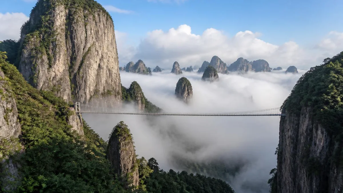
5A View location, maps and nearby scenic areasIn late November 2020 the Canadian astronaut Chris Hadfield posted a short drone video captioned I’d want better handrails. It showed a walkway shaped like a flattened S, curling out from the wall of a forested gorge, apparently unsupported, with a strip of glass down the middle and a great deal of empty air underneath.
A significant portion of the internet concluded it was fake. One reply summarised the mood: too crazy to exist. The fact-checking site Snopes eventually ran an investigation and published a verdict — the Ruyi Bridge is real, it is in Zhejiang province, and it had opened two months before the video went viral.
By the time the argument was happening on Twitter, more than two hundred thousand people had walked across it.
The bridge sits inside a scenic area called Shenxianju — literally where the immortals live — in Xianju county, in the prefecture of Taizhou on the eastern side of Zhejiang. It is a landscape of rhyolite: vertical grey-pink walls, isolated pinnacles, a great deal of cloud. It is also, like most Chinese 5A areas, a container whose boundaries are not obvious from outside, and the most useful thing a visitor can know is exactly what the ticket covers.
What the ticket buys, and what it does not
Shenxianju covers 22.32 square kilometres. Its highest point, Daqinggang, reaches 1,271 metres, and forest covers more than 93% of the ground.
The area splits into two halves, which local naming calls the South Sea and the North Sea — nanhai and beihai — though there is no sea anywhere near. Each half has its own gate, car park and cableway, and they are joined at altitude by a skywalk circuit several kilometres long. That is why people come: up one side, across the top, down the other. Four permutations are sold, including up and down on the same side.
Now the part that wrecks itineraries.
Shenxianju is one of five scenic areas making up the Xianju National Scenic Area, a designation awarded in May 2002. The other four are Jingxingyan, Shisandu, Gongyu and Danzhu; between them the five hold 139 named sights. Only Shenxianju has the 5A. Jingxingyan — a table mountain at 742 metres, about 27 kilometres west of the county town — is described in official sources as adjacent to Shenxianju, not part of it, and sells its own ticket. So do Gongyu, a much-photographed high plateau, and the Danzhu forest valley some 45 kilometres out.
There is a good trap in the Danzhu case. One of Shenxianju’s eight named views is listening to springs at Danzhu, and it is inside the 5A area. Danzhu Leisure Valley, the primeval-forest site, is a different place with a different gate. The words are identical.
Wrapped around all of it is a third and larger entity, Xianju National Park, planned at 301.89 square kilometres plus 44.81 of outer buffer, spanning four townships. In March 2014 Xianju became one of the first two counties in China — the other was Kaihua, in Quzhou — approved as a national park pilot.
So: national park contains national scenic area contains 5A area. Jingxingyan is in the first two and not the third. A guide who tells you the 5A ticket includes it is wrong, and finding that out on arrival is expensive.
A caldera that came back to life
The rock is the reason all of this exists, and it is not local weirdness — it is one piece of something enormous.
Southeastern China carries a belt of Late Mesozoic rhyolitic volcanic rock roughly 1,200 kilometres long and 500 wide, running northeast across Jiangsu, Anhui, Zhejiang, Fujian, Jiangxi, Guangdong and Hainan. Geologists call it a felsic — silica-rich — large igneous province, and it records the Pacific plate grinding against the Asian continent through the Cretaceous. Where it is exposed and eroded it produces a very consistent kind of scenery: steep columnar peaks and long screen-like cliffs.
Which is why Shenxianju looks so much like several other places in the same province. The Yandang Mountains in Wenzhou, Xiandu at Jinyun and Dapan Mountain at Pan’an all belong to the same volcanic system; the neighbouring Linhai geopark, also in Taizhou, dates its eruptions to around 90 million years ago.
What Shenxianju contributes is structural. In volcanological terms it is a textbook resurgent caldera — a collapsed crater whose floor was later pushed back up by renewed magma. The scenic area’s own scientific material calls it a natural museum of rhyolitic volcanism, with the full range of rock types and facies present in one place and columnar jointing exceptionally well developed. The marketing formula is that this is the largest cluster of volcanic rhyolite landforms in the world, best treated as a claim rather than a measurement.
The geology also produced the area’s strangest feature. Rhyolite here forms spherulites — stone bubbles, globular masses grown inside cooling lava. One outcrop, north of Elephant Trunk Waterfall, is classified as a grade-one protected geoheritage point, the highest tier in the park’s scheme. Asked how they form, the national park management committee’s resource planning office gives an unusually honest answer: opinions differ, the types are various, the mechanism is complicated, and no unified account exists. Hold on to that; it matters two sections down.
In 2018 the Shenxianju geopark entered the eighth batch of national geoparks.
The temple underneath the name
Before it was Shenxianju it was the Xiyansi scenic area, and Xiyansi was a temple.
According to the Guangxu-era county gazetteer, the site was the monastic seat of a Northern Song Chan master known as Xueya — the name means snow cliff. The temple stood beneath a huge peak that rises beside it like a single sail, producing the oldest of the area’s set-piece views, the compassionate sail at Xiyan.
Two later figures attach to it. Wu Shilai, from Houren village in Baita town, studied here as a young man; he passed the metropolitan examination in 1553 and rose to be Left Censor-in-Chief — roughly, head of the imperial state’s internal audit and impeachment apparatus, one of the more feared jobs in the Ming. And in 1583, in the Wanli reign, a monk named Guangzheng raised subscriptions and rebuilt the place.
The temple did not survive. It collapsed at the end of the Republican period and only the site remains. What survived was the reputation of the landscape it stood in, which by the late twentieth century had entirely eclipsed it. The area opened commercially in 1998 under the temple’s name, then rebranded.
One inscription from the same stratum does survive: on the walkway now called the Karma Path, a cliff carving reading the first city of mist and rosy cloud, cut in the Qianlong reign by He Shu’e, then magistrate of Xianju.
The modern set of eight views was assembled later and reads as a list of atmospheres rather than objects: the compassionate sail at Xiyan, mist over the painted screen, the chanting of the Buddha-sea, ten thousand cliffs dripping green, sunset over Lichong, spring waves rocked by wind, the tadpole book of heaven, springs heard at Danzhu.
Why the county is called where immortals live
The county’s name is older than the scenic area’s, and it comes with a story the Chinese language still uses daily.
According to tradition, some time around the Tang or Song a man named Wang Wen lived here who was so persistently generous — helping the poor, rescuing people in trouble — that his reputation reached heaven. The immortals came down and transformed him, and in the version everyone knows they transformed his household along with him: family first, then the livestock. The story is the origin of the idiom one man attains the Way and his chickens and dogs ascend with him, used in modern Chinese sourly, about nepotism.
The story goes that the Song emperor Zhenzong (reigned 997–1022) heard of it and decreed that the county, then called Yong’an, be renamed Xianju, the dwelling of immortals. The renaming is a matter of record even if the miracle is not — and the sequence, from legend to imperial decree to place name to tourist brand, has now run for a thousand years.
Li Bai’s mountain, and the quarrel over where it is
Here is the fight, and it is a real one.
Li Bai (701–762) is the poet most non-Chinese readers meet first — the drunk, brilliant, restless one, the closest thing Chinese literature has to a national mythic figure. Among his most anthologised works is Dream Journey to Tianmu: A Farewell Song, an account of flying in a dream over a mountain called Tianmu, the heavenly crone, until the stone doors of a Daoist grotto-heaven crash open.
Every Chinese school textbook glosses Tianmu the same way: a mountain about fifty li east of Xinchang county, in Shaoxing, named because climbers once heard an old woman singing. Ming and Song gazetteers put it there, and in the seventh batch of National Scenic Areas — announced in 2009, designated in 2010 — Xinchang Tianmu Mountain Scenic Area was listed under that name.
Xianju says the textbooks are wrong, and that Li Bai’s Tianmu is Weiqiang Mountain: this mountain. The case has four legs.
Gazetteers. The Southern Song Jiading Chicheng Gazetteer states that Wangmu Mountain lies within the bounds of Xianju county and is also called Tianmu Mountain. The Ming geographer Cao Xuequan, in his Record of Famous Places, identifies Weiqiang Mountain as Tianmu. The Qing Zhejiang Provincial Gazetteer, quoting a Ming source, repeats it.
Toponymy. Zhejiang has historically had six places named Tianmu, and the Xianju argument is that in the mid-Tang the Shan county area had no mountain called Tianmu Shan at all — only a Tianmu Ridge, with the modern name applied after Li Bai rather than before.
Topography. The poem’s most quoted line has Tiantai, at its enormous height, leaning southeast towards Tianmu. Xinchang’s Tianmu lies north of Tiantai and is lower than it, so nothing about it can make Tiantai lean southeast. Weiqiang lies south of Tiantai, and Mishailang, main peak of the Kuocang range it belongs to, is higher than Tiantai’s summit at Huading.
Daoism. The grotto-heaven whose stone doors fly open is identified by the Xianju side as Kuocang Grotto, tenth in the Daoist canon of grotto-heavens, which lies in today’s Xianju.
On 13 October 2018 the Zhejiang Academy of Social Sciences and the provincial Research Institute of Culture and History convened more than thirty scholars at Xianju — among them Qian Wenzhong, Zha Pingqiu and Lin Jiali — for a forum billed as the first ever held specifically to settle where Li Bai’s dreamed mountain was. It proposed restoring the old name.
The response has not been one-sided. The scholar Wu Bei has pointed out that papers on the question already existed thirty years earlier, at the symposia that produced the concept of the Tang Poetry Road of eastern Zhejiang, and that the case needs redoing more rigorously — while adding that she herself inclines towards the Kuocang range. Scholars in Tiantai and Ninghai claim the mountain for their own counties. A legal commentary has argued that Xianju’s promotional use of the identification is one side’s assertion, unratified by any official process. And there is the obvious objection, made frequently online: the poem is about a dream, written by a man whose stock in trade was exaggeration.
The honest position is that this is unresolved. Xianju’s documentary case is stronger than a tourism slogan usually is; the textbook consensus and the national designation still sit with Xinchang; and the argument is simultaneously scholarly and a fight over a brand.
The tadpole cliff
Somewhere on Weiqiang Mountain, above 800 metres, there is a rock face people have been trying to read for sixteen hundred years.
It is called Kedouya, Tadpole Cliff, and the marks on it — variously described as sun patterns, moon patterns, insect and fish forms — have been taken since antiquity for an inscription. Tradition attributes it to Yu the Great, the legendary flood-controller of Chinese prehistory. The Biographies of Divine Immortals records tadpole characters on a stone wall in the Kuocang mountains; the Song Chicheng Gazetteer and the earlier Record of Linhai both mention a cliff written on in tadpole script.
The attempts to reach it form a small comic tradition of their own.
- In the Yixi period of the Eastern Jin (405–418), a court official surnamed Zhou had a flying ladder built and took a wax rubbing. Nobody could identify what it said.
- Later a prefect named Ruan Lu brought a crowd up to look and turned back: the cliff too high, the path too dangerous, cloud and rain over everything.
- In the Northern Song the county magistrate Chen Xiang tried too, and left a poem noting that the year before he had studied a map of Weiqiang marked with ancient seal script written by immortals.
The modern attempts are better documented. In 1985 a cultural-relics survey team from Taizhou photographed the face from a distance with a 28–200mm zoom and enlarged the images point by point; traces appeared to be visible, and that year specialists in relics and palaeography reached the cliff, guided by villagers. The 1986 New Xianju Gazetteer recorded tadpole-shaped marks faintly discernible over about 50 square metres of pale red stone in the ravine beside Tianzhu Cliff.
Then, on 26 May 1994, a local photographic society hired a villager named Pan Yulong, an experienced climber, to abseil from the top and photograph the surface from less than a metre away.
The photographs settled what was there and unsettled everything else. The face is a fairly regular rectangle, roughly 40 by 50 metres, covered in hemispheres protruding about 5 centimetres from the rock, each 7 to 12 centimetres across, with a circular groove some 2 centimetres deep around the edge of each.
Explanations multiplied rather than converged: writing of the ancient She people; a script left by the prehistoric inhabitants of the Xiatang site elsewhere in the county; Yu the Great’s flood-control record, as the villagers had always said; or no writing at all.
A CCTV documentary crew later brought geologists to the cliff to photograph the patterns close up and surveyed rhyolite outcrops elsewhere in Xianju for comparison. Their preliminary conclusion was that the marks are a geological phenomenon — naturally formed spherulitic rhyolite, the same stone-bubble texture protected as a grade-one geoheritage point a few kilometres away. At least one Chinese visitor has noted that the scenic area’s signboards quote the opening of that programme and leave out the conclusion.
The cliff is one of the eight views, under the name the tadpole book of heaven. What you actually see is a distant rock face, from the Taijitai platform near the end of the skywalk circuit. You are not going to read it either.
Guanyin Peak, and the arithmetic of 919
The signature object at Shenxianju is a free-standing rock pillar with more than 200 metres of vertical face, whose summit stands at 919 metres.
The old local name was Tianzhuyan, Sky Pillar Rock, which is descriptive and unremarkable — China has a great many sky pillars. The current name is Guanyin Peak, descriptive in a different way: from the right angles the pillar resolves into a seated figure with its palms pressed together, robed, apparently holding a vase and standing on a lotus. Guanyin is the bodhisattva of compassion, the most widely worshipped figure in Chinese Buddhism.
The scenic area promotes the pillar as the largest natural Buddha image in the world. What makes the claim charming rather than merely commercial is the arithmetic attached to it: 919 metres is read as the ninth month, nineteenth day — the traditional date of Guanyin’s renunciation of lay life, one of three Guanyin festivals in the Chinese calendar.
That is a coincidence pressed into service, and it works, because the pillar genuinely does read as a figure and because the resemblance shifts as you move. Walking up the gorge, the rock changes shape continuously. The honest attraction is not that a mountain looks like a deity, but that it only looks like one from certain places.
Guanyin Peak faces the glass platform at Nantianding across the valley — 919 metres against 869 — and the sightline between them is the composition every promotional photograph of Shenxianju uses.
Six paths in the air, and the bridges between them
The walking is the point, and what you walk on is largely not the ground.
From one cableway’s upper station to the other runs a skywalk system several kilometres long, bolted into cliff faces hundreds of metres above the valley floor. It is divided into six named sections, and the names are a small sermon in sequence: the Bodhi Path, the Prajna Path, the Karma Path, the Guanyin Path, the Flying Eagle Path and the Wuwei Path — wuwei being the Daoist principle of non-action, a curious note to end a strenuous walk on.
Each has a character. The Prajna Path is where the formations are read as the Buddha expounding a sutra to an audience; the Karma Path carries He Shu’e’s Qing inscription; the Flying Eagle Path is the exposed one; and the Wuwei Path ends at Taijitai, looking across at the tadpole cliff.
Threaded through the circuit is a collection of bridges that has become the area’s calling card: the Lotus Bridge, the Reclining Dragon Bridge, the Hongmeng Bridge, the Dream-Fulfilling Bridge, the Blue Cloud Ladder — and two big ones. Nantian Bridge is a suspension crossing about 120 metres long over a vertical drop of some 100 metres, built of steel, planking and rope net. It is the one that moves.
Ruyi Bridge is the one from the video. Built between 2017 and 2020 and opened in September 2020, it crosses the gorge near Sansheng Mountain to give a view of the three peaks there. The structure is three linked spans in the outline of a ruyi, the curved ceremonial sceptre that is a Chinese emblem of good fortune. Official project figures give a span of 95.6 metres and 716 square metres of walkable surface; English-language sources describe it as roughly 100 metres long and about 140 metres above the gorge. Part of the deck is transparent glass, and several parallel routes cross at different levels, so you can choose how much of the drop you want to see. It was designed by He Yunchang, a steel-structure specialist who had earlier worked on the Bird’s Nest stadium in Beijing.
In its first year it drew over 200,000 people. Then Hadfield posted the drone clip, the internet decided it was rendered, and Snopes had to intervene — noting, among other evidence, that Getty photographers had shot it in December 2020.
Four hundred metres of nothing
The other engineered spectacle is Nantianding, the South Sky Summit, and it is a more aggressive object than the bridge.
It is a double-deck steel viewing platform, cable-stayed from a single 30-metre pylon, cantilevered 45 metres out from a cliff edge at 869 metres elevation with roughly 400 metres of air beneath. The deck runs to over 1,000 square metres and is rated for 800 people. Its designers gave it the profile of a spacecraft crossed with an ocean liner and named the idea smooth sailing.
From the front it faces Guanyin Peak directly; east it looks to the town of Xianju, south to Gongyu Rock, north to Zhanglao Mountain, and straight down onto three or four hundred metres of vertical cliff. It is ticketed separately from the main entry, currently at 99 yuan, which is worth knowing before you queue.
What happened after 2015
The ratings ladder is unusually well documented and — refreshingly, given how often these dates disagree — mostly consistent.
- 1998 — opens commercially, under the old name of the Xiyansi scenic area
- May 2002 — designated part of the Xianju National Scenic Area
- December 2005 — rated a national 4A tourist area
- September 2013 — reopens after a county-funded rebuild costing 150 million yuan, marketed as the new Shenxianju
- January 2014 — passes provincial preliminary 5A inspection
- November 2014 — passes the national landscape-quality review
- 23 July 2015 — passes an unannounced expert site inspection
- 8–14 October 2015 — public notice period; Shenxianju and Tiantai Mountain, both in Taizhou, are the only two Zhejiang entries
- 15 October 2015 — the national evaluation committee publishes the announcement approving fourteen areas, Shenxianju among them, as 5A
One discrepancy circulates widely: many Chinese and English sources give the 5A award as December 2015 rather than October. The announcement document is dated 15 October, and the area marked its tenth anniversary as a 5A on 15 October 2025. The December date most likely refers to a local plaque ceremony, which in China routinely happens weeks after the announcement and then gets reported as the date.
The visitor numbers went up. In 2023 Shenxianju received 1.831 million visitors and 372 million yuan in revenue, both records at the time. Xianju county as a whole received 6.26 million visitors in 2024, of whom 3.23 million stayed overnight — up 16.2%, and the more meaningful figure, since overnight visitors turn a day-trip attraction into a local economy. Recent reporting puts Shenxianju above two million visitors a year, against a stated instantaneous carrying capacity of 30,000 people.
How the day actually works
Two cableways, and they are not the same kind of machine.
The Beihai cableway on the north side starts 1.5 kilometres from the north entrance — about twenty minutes on foot — and is a jig-back aerial tram: two large cabins, 1,023 metres of line, 45 people standing per car, about four minutes to the top.
The Nantian cableway on the south side is five minutes’ walk from the south gate and is a detachable gondola: 1,200 metres of line, 38 cabins, eight seats each. Running since September 2020, it climbs 536 metres over 923 metres of horizontal distance, an average gradient of 58%. Above its upper station a pair of escalators carries you the last stretch, which is how a mountain walk in Zhejiang can begin without any climbing at all.
Gates open at 07:00 in summer and 07:30 in winter and close at 17:00, but the number that matters is when ticket sales stop: 15:30 in summer, 15:00 in winter, earlier on busy holidays. Three to four hours is the standard estimate using cableways both ways. Go early — the cloud sea in every photograph of this place is a morning phenomenon, and on a clear day it is gone by mid-morning.
Prices at the time of writing: 110 yuan to enter, 65 up and 55 down on the Nantian cableway, 55 up and 45 down on the Beihai, 99 for Nantianding, 10 for the shuttle between gates. Half price for students and over-60s, free under six and over seventy — and, in a detail that says something about how the place understands its own business, free entry and free cableway for members of the national and provincial photographers’ associations.
The honest version
Shenxianju is a heavily engineered mountain. There is an escalator on it, a glass platform cantilevered off a cliff for 45 metres, a bridge that went viral for looking impossible, and a signboard quoting the first half of a television programme whose second half undermines it. The eight views were curated, the ancient temple is a ruin with no building on it, and the identification with Li Bai’s dream mountain is an argument the county is funding.
All of that is true, and none of it is the reason to go.
The reason to go is that the underlying object is Cretaceous volcanic rock in a configuration that occurs in only a handful of places on earth; that the walk along the top passes through cloud for several kilometres at a height where the valley floor is a rumour; and that on the far side of the gorge there is a rock pillar which, from certain angles and no others, sits up and looks back at you with its hands together.
The immortals in the county’s name were invented. The caldera was not.
The LoreLens app can identify the peaks along the six skywalk paths at Shenxianju, tell you which formations the Prajna Path is named for, and explain the tadpole cliff and the Tianmu dispute in your own language, offline.
Location profile
Where it is

Frequently asked questions
What is actually inside the Shenxianju 5A area, and what is not?
The 5A rating covers Shenxianju alone — 22.32 square kilometres in Xianju county, split into a northern half and a southern half joined by a skywalk circuit and two cableways. It does not cover Jingxingyan, Gongyu, Shisandu or the Danzhu forest valley. Those are the other four components of the Xianju National Scenic Area, they are separately ticketed, and Jingxingyan is 27 kilometres from the county town in a different direction. All of them sit inside the much larger Xianju National Park, planned at 301.89 square kilometres, which is why the marketing blurs them together.
Is the Ruyi Bridge real, or was that video fake?
Real. It was built between 2017 and 2020 and opened in September 2020: three linked curved walkways in the outline of a ruyi sceptre, roughly 100 metres across and about 140 metres above the gorge floor, with a glass trough down the middle. The official project figures give a 95.6-metre span and 716 square metres of walkable deck. It went global when the astronaut Chris Hadfield posted a drone clip on 29 November 2020 captioned 'I'd want better handrails'. Snopes investigated the disbelief and rated the bridge genuine.
Is the tadpole script on the cliff really writing?
Probably not, and the scenic area is coy about it. The marks have been recorded since the Eastern Jin, when an official is said to have built a ladder to take a wax rubbing that nobody could read. A 1994 abseiling expedition finally photographed the face from under a metre away and found protruding hemispheres 7 to 12 centimetres across on a panel of roughly 40 by 50 metres. A CCTV geology crew later concluded these are spherulitic rhyolite, a natural volcanic texture. You cannot get close in any case: the cliff is viewed at distance from the Taijitai platform.
Did Li Bai really dream about this mountain?
Contested, and honestly so. School textbooks gloss the Tianmu of his most famous dream poem as a hill in Xinchang county to the north, and Xinchang holds the national scenic-area designation under that name. Xianju argues that a Southern Song gazetteer, a Ming geography and a Qing provincial gazetteer all identify Weiqiang Mountain — this mountain — as Tianmu, and that the poem's topography only works from here. Thirty-odd scholars met at Xianju in October 2018 to argue it. No consensus was reached, and the poem is explicitly about a dream.
When should I go and how long does it take?
Allow three to four hours if you take a cableway each way, a full day if you walk. Gates open around 07:00 in summer and 07:30 in winter, but ticket sales stop in the early afternoon, so a late start can leave you unable to enter at all. Early morning gives the best chance of the cloud sea the place is photographed for. Check current prices on arrival — the entry ticket, the two cableways and the Nantianding glass platform are all charged separately.