Zhejiang · Wenzhou
Yandang: The Mountains You Cannot See From Outside
The man who invented Chinese landscape poetry governed this stretch of coast in the 420s and walked into every valley he could reach. He never mentioned these peaks. Six centuries later a Song scientist explained the omission — from outside the range there is nothing to look at — and then, in the same paragraph, worked out how the peaks had been made.
5A View location, maps and nearby scenic areasXie Lingyun (385–433) is the founder of Chinese landscape poetry — the writer who first decided that a mountain was a legitimate subject in its own right rather than scenery behind a moral. In 422 he was posted as Grand Administrator of Yongjia, the prefecture that is now Wenzhou, on the southeastern coast of Zhejiang. He treated the job mostly as an excuse. He walked, he took retinues into valleys nobody had asked him to inspect, and he is credited with inventing a kind of studded climbing clog.
He never mentioned the Yandang Mountains, which begin roughly forty kilometres from where he was sitting.
Six hundred and fifty years later Shen Kuo (1031–1095) — a Song polymath whose Dream Pool Essays runs from magnetic declination to fossil bamboo, and who is about as close as pre-modern China comes to a research scientist — came through on survey duty and noticed the same gap. Yandang, he wrote, appears in no earlier map or gazetteer; even Xie Lingyun, who went everywhere in this prefecture, did not record it.
Then he explained why, and the explanation is the best single sentence anyone has written about the place. From outside the range, you see nothing. The peaks do not rise above the surrounding land. Their summits are level with the plateau and their feet are down in the gorges, so the mountain only becomes a mountain once you have walked into it.
And having explained the invisibility, he went on to explain the shape: these forms, he argued, were cut by water — the valleys scoured out, the pinnacles left standing as what the water failed to remove. He compared the effect to the gullied loess country he had seen in the northwest. That is an erosion theory, written down in the eleventh century, about a landscape whose actual origin turns out to be even stranger than he guessed.
The mountain he was describing is now a 5A tourist area, a UNESCO Global Geopark, and one of the first sites China designated when it began protecting scenery at all. It is also, like most Chinese 5A areas, a container — and knowing what is in the container is the difference between a good trip and a long drive.
Three Yandangs, and only one of them is the 5A
Start with the name, because it is attached to three different mountains and this catches people out constantly.
North Yandang — Bei Yandang — in Yueqing, a county-level city under Wenzhou, is the one meant when anybody says Yandang without qualification. It holds the 5A rating, the geopark, the famous waterfall and essentially all of the history.
Middle Yandang, also in Yueqing, and South Yandang, in Pingyang county south of Wenzhou, are separate ranges of the same geological family with their own gates, their own tickets and their own 4A ratings. South Yandang is a genuinely interesting place — Daoist and Buddhist cave sites and a Song-era Confucian academy — but it is about a hundred kilometres from the 5A gates and shares nothing with them except a name.
Then there is the Nanxi River, in Yongjia county, which turns up on almost every Yandang itinerary sold online: clear water, gravel bars and ancient villages laid out on Song geomantic plans. It is a national scenic area in its own right and is not inside the Yandang designation.
The northern range was named in the first batch of National Key Scenic and Historic Areas in 1982, alongside West Lake and Huangshan — the initial list of forty-four that established the category in China. It joined the Global Geoparks Network in 2005, and it was in the first batch of national 5A tourist areas announced in 2007, a small club: the original 5A list ran to sixty-six sites nationwide.
The figure usually quoted for the scenic area is about 450 square kilometres, though sources are not consistent about whether that covers North Yandang alone or all three Yandangs together.
Eight districts, sold separately
Inside North Yandang, the conventional division is into eight scenic districts:
- Lingfeng — Spirit Peak. The night viewing, Guanyin Cave, and the densest concentration of named rocks.
- Lingyan — Spirit Rock. The temple, the two great facing cliffs, the cliff performance.
- Dalongqiu — Great Dragon Pool. The waterfall.
- Sanzhepu — the Three-Fold Falls, in three stages, with a cave you walk behind.
- Fangdong — a cliff walkway and a suspension bridge, the modern one.
- Xianshengmen — a natural rock gate at the head of a gorge.
- Xianqiao — Immortals’ Bridge, high and remote, with a natural stone arch.
- Yangjiaodong — Goat’s Horn Cave, a Daoist cave complex, the least visited of the eight.
The first three are the old three marvels, the set every classical account of the mountain is organised around, and they are close enough together to do in a single very full day. The commonly cited new three — Fangdong, Xianshengmen and Yangjiaodong — is a later marketing construction, but a useful one: those three are where you go when the first three are full of people.
The practical point is that these are not one ticket. Districts are gated and charged individually, with combination passes that change from season to season. Confirm current pricing on arrival rather than from any article, this one included, and budget for buying admission four or five times over two days.
Four eruptions, and a crater that kept collapsing
Shen Kuo was right that water shaped these peaks and wrong about what it was shaping.
Yandang is a volcano — an extinct caldera of the Early Cretaceous, roughly 120 million years old, part of the enormous belt of rhyolitic volcanic rock running northeast across southeastern China from Guangdong to Jiangsu. That belt produces the same scenery wherever it is exposed and eroded: vertical grey-pink walls, isolated columnar pinnacles, screen-like ridges with no foothills. It is why Shenxianju in Taizhou, a couple of hours north, looks like a sibling of this place. It is one.
What the geopark literature presents Yandang for is the completeness of the sequence. The volcano’s life is reconstructed in four stages — eruption, collapse of the crater floor, resurgence as magma pushed the floor back up, and final extinction and erosion — and all four are said to be legible in the rock exposed today, in order, within one compact area. Most ancient calderas are known from one or two surviving pieces of the cycle.
The erosion is the part you actually see. Rhyolite that cooled in thick sheets developed vertical joints; water and frost worked down those joints for tens of millions of years; the joints became gorges and the blocks between them became towers. That is why the peaks here so often read as objects rather than as terrain — a pillar, a screen, a pair of hands, a folded eagle. The rock breaks into slabs and columns rather than slopes.
The interpretation boards on the main trails are unusually good on this. If you have any interest at all in why a landscape looks the way it does, read them; they are more informative than the ones about the legends.
The lake that named the mountain, and then dried up
The name is Yandang — wild goose, and dang, a shallow marshy lake.
High on the range, at around a thousand metres, there is a basin called Yanhu, Goose Lake. The traditional account is that it held standing water and reeds, and that migrating geese came down onto it in autumn, and that the mountain took its name from this: the marsh where the geese stop.
The lake is largely gone. Silt, vegetation and drainage have converted it over the centuries into wet grassland and boggy ground with a few remnant pools, and what you reach after a long, mostly viewless climb is a high open plateau rather than a body of water. Yanhu is among the least visited parts of the range, which is the sensible response to a hard walk with a modest reward.
Go up anyway if you have the day, for a reason that has nothing to do with the view: this is where the mountain’s most famous piece of fieldwork was done, and it was done to disprove something.
The mountain nobody wrote down
Shen Kuo’s observation raises the obvious question. If Yandang is spectacular and forty kilometres from a prefectural seat, how did the entire Chinese literary tradition miss it until the eleventh century?
Part of the answer is his own: you cannot see it, so there is no distant profile to draw a traveller in. Part of it is that the interior was rough, forested and thinly populated. And part is simply that fame in classical China was a documentary process — a place became famous by being written about, and until someone wrote, there was nothing to attract the next writer.
The received chronology, as the local gazetteer tradition tells it, is that woodcutters and hunters knew the valleys, that monks moved in during the early eleventh century, and that the monasteries made the mountain legible. The great period of temple building here is the tenth and eleventh centuries, and local tradition counts eighteen ancient monasteries founded in that window, most of which are now sites rather than buildings.
There is an earlier thread, religious rather than documentary. Tradition holds that a monk called Nuojunuo, identified with one of the arhats — the enlightened disciples of the Buddha — came here with a company of followers and settled in the mountain. The names Yandang and Longqiu, the dragon pool, are traditionally said to appear together for the first time in a verse in praise of him by Guanxiu (832–912), a late-Tang monk best known as a painter of deliberately grotesque arhats. That would push the mountain’s first written appearance back to the ninth or tenth century.
Hold it as tradition rather than as a citation. But it fits: the arhats arrive, then the monasteries, then the poets, and only then does Shen Kuo turn up to ask why nobody had noticed.
Lingfeng, twice
Lingfeng is the district nearest the main gate and the one to do twice, because the daytime version and the night version are effectively different attractions.
By day it is a bowl of towers, with a temple, an easy loop and a great deal of vertical rock. The set piece is Hezhang Feng — Joined Palms Peak — two enormous slabs leaning together like hands pressed in prayer. In the cleft between them, wedged into the rock rather than built beside it, is Guanyin Cave: a temple of nine storeys stacked up inside the fissure, climbing on stairs from the daylight at the bottom to the shrine at the top, with the walls converging overhead the whole way. The cleft is recorded at something over a hundred metres high. It is the strangest building in the range and a genuinely unnerving climb.
After dark the district turns into something else. Lingfeng night viewing is Yandang’s signature, and the mechanism is straightforward: guides walk you to specific marked positions, you look up at silhouettes against the sky, and the rocks resolve into figures that are invisible in daylight because daylight gives you texture and detail instead of outline.
The same Joined Palms Peak, from a different angle at night, becomes Husband and Wife Peak — two figures leaning into each other in an embrace. Elsewhere on the loop the standard readings include a rhinoceros with its head up looking at the moon, and an eagle with its wings folded. Nothing is lit; the effect depends entirely on where you stand and how much sky is behind the rock.
It sounds like a gimmick and it is not, quite. What makes it good is that the transformations are conditional. Move ten metres and the couple becomes two slabs of rhyolite again. Go on a clear night, and if you can, on a night with a moon.
Lingyan, and the men on the ropes
Lingyan is the district with the temple and the two great cliffs, and the most theatrical thing that happens in the range happens here several times a day.
The two rock walls facing each other across the temple forecourt are Tianzhu Feng, the Sky Pillar, and Zhanqi Feng, the Unfurled Banner — the second genuinely does read as a flag stretched taut, flat-surfaced and fluted at the edge. Both are usually given at between 250 and 270 metres of vertical face. Behind them run the Xiaolongqiu waterfall, the Small Dragon Pool, and a valley walk through the cleft.
Also here is Longbi Dong, the Dragon’s Nose Cave, whose walls carry a concentration of cliff inscriptions — on the order of eighty of them, cut by visitors across roughly a thousand years, the earliest attributed to the Tang. Chinese cliff inscriptions are the closest thing the tradition has to a visitors’ book kept by people with chisels.
The performance is called feidu, the flying crossing. A line is strung between the two peaks, and a man works his way across it, several hundred metres above the forecourt. A second act sends performers down the vertical face of Tianzhu on ropes, dropping in stages.
The important thing about it is where it came from. These cliffs grow dendrobium, a medicinal orchid valuable in Chinese pharmacy for centuries, along with other cliff-rooted plants. Collecting it meant going over the top edge on a rope, alone, and working the face. The show is that job, scheduled and given an audience — rope technique that predates the tourism by a very long way, and in the traditional form there is no net.
It runs on a posted timetable that shifts with the season, and it is over in a few minutes. Ask at the gate, and get there early: everyone in the district converges on it.
Dalongqiu, and what happens when it stops falling
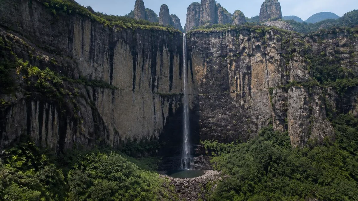
Dalongqiu — the Great Dragon Pool — is the fall the mountain is famous for, and it is a single uninterrupted drop off the lip of a cirque into a plunge pool at the bottom. The height is usually given as 197 metres, occasionally as 190; either way it is among the tallest single-drop falls in China and is standardly listed among the country’s handful of great named waterfalls.
The approach is a flat, easy walk up a gorge with the cliff closing in ahead, and the fall is visible for much of it, which is unusual and part of the pleasure.
What makes Dalongqiu genuinely interesting is what it does when there is not much water.
Two hundred metres is a long way to fall. In low flow, the stream leaves the lip as a rope, breaks up on the way down, and turns into drifting mist and rain that dissipates before it reaches the pool at all — so the fall arrives at the bottom as weather rather than as water. Wind pushes it sideways; the whole column swings. Classical writing on this waterfall is preoccupied with exactly that: the Qing writer Yuan Mei (1716–1797), in an essay comparing three Zhejiang waterfalls, describes it as behaving less like a fall than like smoke.
The practical consequence is blunt. After heavy rain you get thunder and spray and a wall of white. In a dry autumn week you get a thread and a lot of atmosphere. Both are worth seeing; they are not interchangeable, and it is worth knowing which you are going to get before spending the half day.
Xu Xiake, three visits, and a strip of torn cloth
Xu Xiake (1587–1641) is China’s great travel diarist — a man of independent means who spent thirty years walking the country and writing down what he saw with an obsessive concern for whether it was actually true. China’s National Tourism Day is 19 May because that is the date in 1613 on which his surviving diary opens, at Mount Tiantai, about a hundred kilometres north of here.
He came to Yandang on that same 1613 journey, and returned twice more in 1632.
The 1613 visit produced the episode everybody retells. The gazetteers of the day asserted that Dalongqiu was fed by Yanhu — the goose lake on the summit plateau. It is a tidy claim: great lake above, great waterfall below. Xu Xiake went up to check it.
He and his companions worked their way onto the high ground, found the route blocked, and attempted to get down a cliff by tearing cloth into strips, knotting them into a line and lowering themselves on it. The improvised rope was not long enough. They ended up stranded on a ledge, hauled themselves back up, and got off the mountain another way. It is one of the most vivid passages in the Travels precisely because he records the failure rather than tidying it out.
And the conclusion he drew was negative, which is why it matters: the goose lake does not feed the great waterfall. He said so, against the received local text, on the strength of having gone and looked.
The line most often quoted from his Yandang writing is that you would need to be a flying immortal to exhaust the marvels of this mountain, and it is repeated on signboards throughout the range. The better souvenir of his visits is the torn cloth.
An iron cauldron, and the eighteen monasteries
The monastic layer that made Yandang famous is mostly gone, and what survives of it is worth an hour rather than a day — with one object that is worth going out of your way for.
At Nengren Temple, in the Dalongqiu district, stands an enormous iron cauldron cast in 1084, in the Yuanfeng reign of the Northern Song. It is a working vessel rather than a votive one — the kind of cauldron a large monastery used to feed itself — and its scale is the point: the mouth measures something close to three metres across, and the recorded weight runs to many tonnes. It has sat in the open for over nine hundred years.
That single object tells you more about the mountain’s Song period than any of the rebuilt halls do. A cauldron that size implies a community large enough to need it, in a valley that a century earlier had no written existence at all. The eighteen monasteries were not hermitages. They were an economy.
Most did not survive the Ming and Qing, and the buildings you see at Lingyan, at Guanyin Cave and at Nengren are reconstructions of varying age and honesty. The cauldron is not.
The other five districts
Beyond the classic three, the range gets quieter fast.
Sanzhepu, the Three-Fold Falls, is the best of the rest and the easiest to add. Three separate falls — lower, middle and upper — occupy one steep valley. The middle one is the reason to go: the water drops across the mouth of a vast arched hollow undercut into the cliff, and the path takes you in behind the curtain, so you stand inside the arch looking out through falling water. Cool, loud, and a short walk.
Fangdong is the modern intervention: a walkway bolted along a cliff face several hundred metres up, running for around a kilometre, with a suspension bridge across the gap between two ridges and a cable car to save the climb. It is the best overview of the caldera terrain in the range, because it puts you at mid-height looking across the towers rather than up at them from the floor.
Xianshengmen is a natural rock gate: two facing walls, commonly given at around 250 metres, at the head of a gorge with a narrow gap between them, promoted locally as the largest natural rock gateway in the country. The walk in follows a stream and is one of the emptiest good walks in the area.
Xianqiao, the Immortals’ Bridge district, sits high and takes in a natural stone arch and the ground above the great waterfall, which is a strange thing to stand on. Yangjiaodong is a Daoist cave complex, the least developed of the eight and the one that still feels like a shrine rather than an attraction.
Getting there, and how to spend the time
Yandang is on the coastal side of Zhejiang, roughly seventy kilometres northeast of Wenzhou, and the high-speed line between Ningbo, Taizhou and Wenzhou has a station named for it — though the station is some distance from the gates and you will need a bus or a taxi at the other end. The range is close enough to the sea that the weather is maritime: humid, frequently cloudy, and exposed to typhoons in late summer, which can close trails at short notice.
The sensible shape of a visit is two days. Day one: Lingyan in the morning for the temple, the two cliffs and the cliff performance; Dalongqiu in the afternoon, which is a flat walk and rewards a late light; and Lingfeng after dark. Day two: Sanzhepu or Fangdong, plus Lingfeng again in daylight to see what the night was hiding.
Three days lets you add Xianshengmen or the climb to Yanhu. One day forces a choice, and the choice should be to keep the night viewing, which exists nowhere else.
Spring and autumn are the good seasons. Late spring gives the waterfalls their volume; autumn gives the clearest nights, which is what the Lingfeng loop needs. Summer is hot, crowded and wet, though the falls are at their most violent after a typhoon passes. Winter is quiet, and the falls are thin.
The honest version
Yandang is a developed mountain. There are cable cars, a cliff walkway, a scheduled acrobatic show, gated districts with separate tickets, and a great many named rocks whose names were assigned by people who wanted them to be memorable. The goose lake that gave the range its name is a bog. The eighteen monasteries are mostly foundations. A significant fraction of what you are shown is a resemblance that only works from a painted footprint on the ground.
All of that is true.
What is also true is that the rock is an Early Cretaceous caldera whose whole life cycle is legible in one place; that a Song official standing in these gorges in the 1070s looked at the towers and correctly deduced that running water had made them, seven centuries before geology existed as a discipline; that a diarist in 1613 tore up his clothes to test whether a lake fed a waterfall, and published the answer that contradicted the official record; and that on a clear night, from one particular flagstone in the Lingfeng valley, two slabs of volcanic rock that spent the day being a pair of hands become, unmistakably, two people holding on to each other.
The mountain still cannot be seen from outside. That has not changed since Shen Kuo pointed it out. You have to go in.
The LoreLens app can identify the named peaks on the Lingfeng night loop, tell you which rock you are meant to be looking at from where you are standing, and explain the caldera geology and the Song monastic history in your own language, offline.
Location profile
Where it is

Frequently asked questions
What does the Yandang Mountains 5A actually cover?
North Yandang, in Yueqing city, and nothing else. The area is conventionally divided into eight districts — Lingfeng, Lingyan, Dalongqiu, Sanzhepu, Fangdong, Xianshengmen, Xianqiao and Yangjiaodong — and most of them are ticketed separately rather than on one pass. Middle Yandang and South Yandang are different mountains in different places with their own 4A ratings, and the Nanxi River, which many itineraries bolt on, is a separate national scenic area in Yongjia county. There is no single ticket that covers all of that.
How many days do you need, and which districts matter most?
Two days covers the traditional core comfortably: Lingyan and Dalongqiu on one day, Sanzhepu or Fangdong on the other, and Lingfeng twice — once by day and once after dark, because it is a different place at each. One day is possible but forces you to skip the night viewing, which is the single most distinctive thing the mountain does. Add a third day if you want Xianshengmen or Yangjiaodong, which are further out and much quieter.
Why is the mountain named after wild geese if there is no lake?
There was one. Yanhu — Goose Lake — is a shallow basin high on the range where reeds grew and migrating geese were said to rest; dang means a marshy shallow lake, so the name is roughly the marsh where the geese stop. The basin has silted and largely dried, and what you walk across today is grass and boggy ground with small pools rather than open water. The mountain is named after a feature that has substantially ceased to exist.
Is Dalongqiu always worth the walk?
Not always, and it depends entirely on rain. At high flow it is a single unbroken drop of nearly 200 metres into a pool, which is the reason for its reputation. In dry weather the same fall thins to a ribbon that disperses into drifting mist and rain before it reaches the ground — spectacular in a completely different register, and disappointing if you arrived expecting volume. Late spring and the weeks after the summer typhoons give the most water. Check recent rainfall before you commit the half day.
Are the cliff acrobatics at Lingyan a modern invention?
The performance is modern; the skill is not. Local men worked these faces for dendrobium and other cliff-growing medicinal plants, using ropes, and the show — a traverse on a line strung between Tianzhu and Zhanqi peaks, plus a descent down the rock face — formalised that work into a scheduled act performed several times daily above the Lingyan temple forecourt. The traditional version uses no net. Times are posted at the gate and change with the season.