Zhejiang · Quzhou
Mount Jianglang and Nianbadu: Three Slabs of Rock and Thirteen Dialects
One 5A rating covers two places an hour's drive apart with nothing obvious in common: a World Heritage rock formation of three vertical slabs, and a small town in a mountain valley whose few thousand residents are said to carry one hundred and forty-two surnames and thirteen dialects between them. The connection is not scenery. It is the pass.
5A View location, maps and nearby scenic areasIn most old Chinese villages, the surnames run out fast. One lineage, sometimes two or three, an ancestral hall with a single family name over the door, and a genealogy that explains why everybody is related to everybody else.
Nianbadu publishes a different number. A town of a few thousand people, in a valley in the mountains of southwest Zhejiang, it claims one hundred and forty-two surnames and thirteen dialects.
Forty-odd kilometres north of it, three slabs of red rock stand upright out of a hillside, and in 2010 UNESCO put them on the World Heritage List.
These two things share a 5A rating, which in the Chinese system is the top grade a scenic area can hold. They do not share a landscape, a period, a subject or a road that takes less than an hour. Most write-ups treat the pairing as an administrative accident and describe the rock and the town as if they were unrelated.
They are not unrelated. The reason a village in a mountain valley accumulated one hundred and forty-two surnames is the same reason the mountain range here is worth looking at: this is a wall, and there is one gap in it.
Three slabs, and a character that means half a log
Start with what you are actually looking at, because photographs flatten it badly.
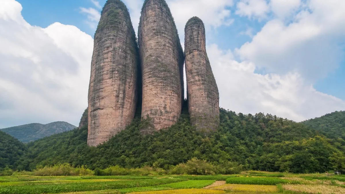
Mount Jianglang — Jianglangshan — is not a mountain in the sense of a ridge or a summit. It is three separate towers of rock standing more or less in a line on the flank of a hill, with sheer walls, flat tops and open sky on every side. The local name for them is sanpanshi, the three pan stones, and the middle character is worth a moment. Pan is a rare word meaning one half of a split log — a slab, a plank, the thing you get when you take an axe to a round of timber. Not three peaks. Three slabs.
They are named, from north to south, Lang Peak, Ya Peak and Ling Peak. Lang is the largest and the only one with a visitor route to the top; its summit is usually given as around 824 metres above sea level, and the rock itself rises something over three hundred metres from its own base, which is the number that matters when you are standing under it. Ya and Ling are lower and narrower, and they lean into each other closely enough that the gap between them functions as a corridor rather than a valley.
Seen from the standard viewpoint on the approach road, the three read as the Chinese character for river, three parallel vertical strokes, and every local description says so. Seen from underneath, they do not read as anything. They are simply walls that begin at eye level and end in cloud, and the effect is closer to architecture than to landscape.
The scale is hard to hold because there is nothing familiar next to it. The usual trick is to wait until somebody starts up the stair on Lang Peak and see how far up they get before they stop being visible.
What Danxia is, and why this one is the last chapter
The rock is red because of what it is made of, and the shape follows from the rock.
Danxia landform is a Chinese geomorphological category, named for Danxiashan in Guangdong, and it has a strict definition: it develops on relatively hard red terrestrial beds — conglomerate, sandy conglomerate, sandstone — laid down mostly in the Cretaceous in inland basins, and its diagnostic feature is the cliff. Red walls, steep sides, flat or gently sloping tops, a debris apron at the foot. If a red hill is rounded rather than walled, it is something else, whatever the sign at the gate says.
What produces the cliffs is the combination of a rock strong enough to stand vertically and a joint system that cuts it into blocks. Uplift raises the beds, rivers and rainfall exploit the joints, and the basin is progressively taken apart along its own fracture lines. The blocks that survive get smaller and more isolated with time.
That last sentence is why Jianglangshan is on the World Heritage List rather than simply being a handsome rock.
The Chinese literature describes Danxia terrain as passing through stages, using an explicitly biological vocabulary — youth, maturity, old age. Early on you have a plateau barely dissected, a red tableland with canyons cut into it. In the middle stages the canyons widen and the tableland breaks into ridges and blocks. At the end you have isolated residual towers standing on a plain of softer ground, the last unweathered fragments of what was once continuous rock, with the surrounding material gone.
Jianglangshan is the textbook illustration of that final stage. There is no plateau left. There are three pieces of it.
Six sites, one inscription
China Danxia was inscribed on the World Heritage List in 2010, as a serial natural property with six components, all of them in the humid subtropical southeast of the country: Chishui in Guizhou, Taining in Fujian, Langshan in Hunan, Danxiashan in Guangdong, Longhushan in Jiangxi, and Jianglangshan in Zhejiang. They lie strung along a crescent roughly 1,700 kilometres from west to east.
The nomination originally proposed nine sites and was cut to six at a seminar in Beijing in January 2009. The logic of the surviving set is comparative rather than competitive: the components were chosen to demonstrate the range of the landform and, crucially, the range of its development stages, from barely dissected plateau to isolated residual peak. Langshan and Danxiashan were regarded in the evaluation as the clearest demonstrations of the type.
Jianglangshan’s role in that set is to be the end of the sequence. It is small — the smallest of the six by a wide margin — and it is not the most spectacular by most measures. What it is, is finished. Whatever was between and around those three slabs is now soil somewhere downstream.
This has a practical consequence for a visit. Chishui and Taining are landscapes you travel through for days. Jianglangshan is one object, and you can see the whole of it from a single field.
The stair up Lang Peak
You can climb one of the three.
A stone route runs up Lang Peak — steps, galleries, ledges, sections cut into the rock and sections built out from it on brackets, threading up and around the tower to a small summit area with a temple and a view over the Quzhou hills. The other two slabs have no visitor route to the top. Ya and Ling are looked at, not climbed.
The climb is a stair, not a scramble. There are handrails throughout. It is also continuous, steep, and in the upper sections quite exposed, with the galleries running along the outside of a vertical wall and the drop immediately beside your feet. People who are fine with heights find it exhilarating; people who are not sometimes turn back partway, and there is no shame in it, because the best view of the formation is from the ground anyway.
At the foot of Lang Peak sits a Buddhist temple, and the combination is the standard photograph: tiled roofs, a courtyard, and directly behind them a wall of red conglomerate going up out of frame. Chinese religious siting has a long habit of putting buildings at the base of things that are already impressive, and letting the rock do the work.
Allow two to three hours for the round trip at an unhurried pace, more if you stop, and take water. There is no reliable shade on the upper sections. Avoid the climb in heavy rain — the steps are slick, and a Danxia cliff sheds water off its face in a way that lands on the galleries.
The gap between the second and third peaks
The single best-known feature here is not a peak. It is the space between two of them.
Ya Peak and Ling Peak stand close enough together that the gap between them forms a slot — a one-line sky, in the standard Chinese phrase for a fissure so narrow that the sky is reduced to a bright stripe overhead. Local figures put the length at around three hundred metres, with the width varying from a few metres at the tightest points to perhaps ten at the widest, and walls of two or three hundred metres on both sides.
The site claims it as the largest natural formation of its type in China, and possibly further. Take the superlative as marketing and the sensation as real. The interesting thing about walking it is not the record but the physics: the slot has its own microclimate, several degrees cooler than the field outside, damp underfoot, with ferns and moss on the lower walls and a permanent draught moving through it. On a bright day the contrast at the two ends is violent enough to leave you blind for a few seconds.
It is also the clearest evidence in the whole place for how the formation was made. The slot is a joint. Two blocks of the same rock, separated along a plane of weakness that water then spent a very long time widening. Every other cliff you can see here was made the same way; this is just the one that has not finished separating.
Three brothers, and four lines by a general
The name Jianglang means, more or less, the Jiang lads, and the story attached to it is the one you will be told at the gate.
Three brothers surnamed Jiang, the story goes, climbed the mountain and were turned to stone where they stood — hence three towers of rock standing in a row, hence the name. Variants have them ascending to become immortals, or petrified as a reward rather than a punishment. The mountain is also recorded under older names in the gazetteer tradition, which is the usual sign that the Jiang story arrived to explain a shape rather than the other way round.
Treat it as a folk etymology and it is still worth knowing, because it tells you what the formation looks like to people who live under it. Three figures, standing, in order of height.
The more interesting literary attachment is a poem. Xin Qiji (1140–1207) — a Southern Song general and one of the two or three greatest lyric poets in the language, a man who spent his career arguing for a war of reconquest against the Jurchen north and mostly being ignored — wrote four lines about this mountain that are quoted on every sign in the scenic area. In plain translation, without trying to reproduce the metre:
Three peaks, each one as green as though pared with a blade, standing a thousand fathoms and not to be assailed. Upright, holding one another up, with nothing to lean on, propping up heaven and earth for people to look at.
It is a poem about the rocks and it is obviously not about the rocks. Xin Qiji spent decades as an official whose strategic advice was declined, in a court that had chosen accommodation over reconquest, and he saw three vertical objects supporting each other with no external support and wrote down what he felt about it. The rock is a better metaphor than most because it is genuinely doing the thing described: three slabs, mutually buttressed, standing where the rest of the plateau fell.
The Ming traveller Xu Xiake (1587–1641), whose diaries are the foundation text of Chinese travel writing, came through this corridor in 1620 on his way south into Fujian, and the country around Jianglangshan and the pass beyond it appears in his record of that journey.
The pass that a rebel opened
Now walk south, because the second half of this 5A rating is on the other side of a mountain range.
The Xianxia range is part of the divide between Zhejiang and Fujian, and for most of Chinese history it was the reason Fujian was difficult. Fujian is a coastal province walled off from the interior by mountains; its historical orientation was toward the sea, and its land links north were few and bad. The Xianxia road was the main one — the overland corridor from the Qiantang river system in Zhejiang over the divide and down into the Min river system in Fujian, and thus the land route from the Yangtze delta to Fuzhou.
Tradition and local record credit the opening of the road to Huang Chao (died 884), the failed examination candidate and salt smuggler whose rebellion tore the late Tang dynasty apart and who sacked the imperial capital before being destroyed. In 878, on his way south into Fujian, he is said to have cut a road through the Xianxia mountains for his army. Whether he built it or improved something already there is not resolvable at this distance, and the attribution has the shape of the kind of thing later gazetteers like to record. What is not in doubt is that a road existed here, that it was fortified, and that the pass above the town — Xianxia Pass — was a military installation with a garrison for centuries afterwards.
Here is the part that explains the town. River navigation from Hangzhou and the delta ran up the Qiantang system as far as the wharves near Jiangshan, and stopped. From there to the navigable water on the Fujian side, everything had to go overland, over the pass, on the backs of porters and animals. Silk, tea, paper, salt, dye, tobacco, timber, and the people carrying them.
A break-of-bulk point is where money accumulates. Nianbadu sits on that overland leg, in a valley below the pass, and it grew into the thing such places grow into: warehouses, inns, brokers, a garrison, and a permanent population of people who came from somewhere else.
Canton number twenty-eight
The town’s name is an administrative serial number, and this is not a joke.
Nianbadu means, literally, the twenty-eighth du. The first character, nian, is the specific written form for twenty, so the name reads as twenty-eight. The du was a rural administrative unit of the Song and later — a canton, a subdistrict, the kind of division a county is chopped into for tax and militia purposes. When Jiangshan county was divided into numbered cantons under the Northern Song, this valley was number twenty-eight, and the number stuck to the settlement and never came off.
So the town is called Canton Twenty-Eight. It has been called that for something close to a thousand years, and it now appears in that form on the World Heritage-adjacent tourism brochure of a provincial government.
There is something appropriate in this. A town founded by outsiders, on a road, at a garrison, populated by people from four provinces who did not share a lineage or a language, would have had a hard time acquiring the usual sort of Chinese place name — the ones that come from a founding family, a temple, a local feature, a shared origin. Nianbadu has no founding family. It has a serial number from a tax register.
A hundred and forty-two surnames
The figure the town publishes is 142 surnames among a population of a few thousand, and it markets itself as the town of a hundred surnames — a phrase that in Chinese usage means, roughly, everybody.
To see why that is remarkable you need the baseline. A normal Chinese village of this size and age would be dominated by one to three lineages. Land passed within the family, ancestral halls organised social life, genealogies were kept, and the village and the surname were substantially the same institution. Villages are commonly named after their lineage for exactly this reason.
Nianbadu got its population the other way. Garrison troops posted to the pass, in successive dynasties, from wherever the army recruited them. Merchants who came to trade and stayed to run warehouses. Porters and muleteers working the overland leg. Refugees moving along the road during the various collapses. Almost nobody’s ancestors were here first, and there was no dominant lineage to assimilate into.
What that produced is visible in the built fabric. The town has multiple ancestral halls for different surnames, standing within a few hundred metres of one another, which in a normal village would be structurally impossible. It also produced an unusual density of temples for a place of its size, since incomers bring their own gods and do not necessarily accept anyone else’s.
The exact number should be held loosely — surname counts of this kind are typically compiled from household registers at a particular moment and then repeated indefinitely. The pattern behind the number is not in doubt.
Thirteen dialects in one valley
The linguistic claim is the more interesting one, and it is the thing that gets Nianbadu described as a dialect island.
Set the geography first. Jiangshan county’s own local speech is a Wu dialect, of the Chu–Qu group that occupies the southwestern corner of the Wu-speaking region. Wu is the family that includes Shanghainese and Suzhou speech, and it is not mutually intelligible with Mandarin. Over the pass to the south lie Min dialects, the Fujian family, which are not mutually intelligible with Wu either, or in some cases with each other. West across the provincial line is Gan, in Jiangxi. Nianbadu sits close to the point where the three provinces meet, which is also close to the point where three major dialect families meet.
Against that background, the local prestige variety of Nianbadu is a Mandarin-based form — locally called something along the lines of the proper speech — which is not the language of any of the surrounding countryside for hundreds of kilometres in any direction. The standard explanation is the garrison: soldiers posted in from elsewhere spoke a northern-based military koine, that speech carried official prestige in a town whose business was official traffic, and it became the town’s common tongue rather than being absorbed by the Wu around it.
On top of that base, the town’s own count lists thirteen varieties in use — the Mandarin form, the surrounding Wu, Min varieties from over the border, Gan from Jiangxi, and a set of smaller speech communities associated with particular incoming groups.
Two honest qualifications. First, thirteen is a count made by someone, and the boundary between a dialect, a sub-dialect and an accent is a judgement call rather than a measurement; other counts circulate. Second, this is a linguistic situation in retreat. The road stopped being the road when railways and then highways went elsewhere; the young have been leaving for two generations; and universal Mandarin education has done here what it has done everywhere. The thirteen dialects are a description of what the town was, and only partly of what you will hear in it.
What stands on Feng Creek
The physical town is a single long street following a creek — Feng Creek, the Maple Creek — through the valley, with the buildings on both banks and bridges across.
The surviving fabric is Ming and Qing, and there is a substantial quantity of it: several dozen historic buildings of note, ancestral halls, temples, merchant houses with internal courtyards, and shop fronts along the street with the counters and boards still in place. It is on the national list of historic and cultural towns.
Two things distinguish it architecturally from the water towns most visitors to Zhejiang see. The first is that it is a mountain town, not a delta one: stone footings, timber frames, whitewash and dark tile, built for cold nights and steep ground rather than for boats. The second is the mixture. Because the money came from four provinces, the decorative vocabulary did too — you can find Huizhou-style gable walls, Fujianese detailing and Jiangxi carpentry within the same few hundred metres, sometimes on the same building. Merchant houses built by people who had come from somewhere and wanted the front of the house to say so.
The most photographed single building is the Wenchang Pavilion, the temple of the god of literature and examinations, a multi-storey timber structure with painted panels across its ceilings and beams. Wenchang temples are common; a large and lavish one in a small mountain town is a statement about what the merchants there wanted for their sons.
The town also holds a set of living traditions — glove-puppet theatre, mountain songs, a distinctive local cuisine that owes as much to Fujian as to Zhejiang — and a genuinely good tofu tradition, which in this part of China is a competitive field.
One modern footnote, handled carefully. Jiangshan county produced Dai Li (1897–1946), the head of Chiang Kai-shek’s military intelligence service, a man whose organisation recruited so heavily from his home county that the connection became proverbial. Local material in Nianbadu makes various claims about his presence here and about buildings associated with the service. The general point about Jiangshan and the intelligence apparatus is well established; the specific building attributions vary from account to account, and this piece will not repeat any of them as fact.
One rating, two places, an hour apart
The compound name — Jianglangshan and Nianbadu, with a dot between them — tells you exactly what happened. Two sites in the same county-level city, each strong but neither on its own quite a national-headline destination, were assessed and promoted as a unit.
This is normal. Chinese 5A designations are frequently containers rather than places, and the more useful question is not whether the pairing is coherent but what it does to your itinerary. Here the answer is simple and worth planning around: they are roughly an hour apart by road, on a route that keeps climbing, and there is no version of this where you do both properly in a rushed morning.
But the pairing is more defensible than most. The mountain and the town are two consequences of the same fact. Cretaceous red beds were laid down, uplifted and then dissected, leaving both the residual towers at Jianglangshan and, more importantly, a range that made this stretch of the Zhejiang–Fujian border effectively impassable except in a few places. The road went where the mountains allowed. The town grew where the road had to stop and unload. The surnames and the dialects arrived on the road.
You are not looking at a rock and a town. You are looking at a barrier and its one gap, from both ends.
Going
Jiangshan is reachable by high-speed rail from Hangzhou, and Quzhou is the nearest larger city. From the town of Jiangshan, Mount Jianglang is roughly twenty-five kilometres south and Nianbadu roughly another forty beyond it, toward the Fujian border. Public buses exist but are infrequent; most visitors drive or hire a car for the day, and a car is close to essential if you want both sites without losing half a day to waiting.
The sensible shape of a visit is two half-days, or one long day done in the right order: the mountain in the morning, when the light is on the east faces of the slabs and the stair is not yet hot, and Nianbadu in the afternoon and evening, when the day-trip coaches have gone and the street belongs to the people who live on it.
Season matters more here than at most sites, because the main activity is a long exposed climb. April to May and late September to early November are the reliable windows. The plum rains from late May into July are the worst of it. Winter is clear and very quiet, and the galleries on Lang Peak are cold in a way that a stair climb does not fix.
Tickets for the two sites are sold both separately and in combination, and the combinations change; confirm on the day rather than from any article, this one included.
And one small thing to do while you are on the ground at Jianglangshan, before you start up the stair. Walk out into the field on the approach side, far enough back that all three slabs fit in your field of view without turning your head, and look at the ground between them and under them. Everything you are standing on used to be up there.
The LoreLens app can identify the three peaks and the Danxia features at Jianglangshan, and explain the ancestral halls, temples and merchant houses along Feng Creek in Nianbadu, in your own language, offline.
Location profile
Where it is

Frequently asked questions
What does the Jianglangshan and Nianbadu 5A rating actually cover?
Two separate sites in Jiangshan, a county-level city under Quzhou in southwest Zhejiang, joined administratively rather than geographically. The first is Mount Jianglang, a Danxia formation of three near-vertical rock slabs about twenty-five kilometres south of the city, inscribed on the World Heritage List in 2010 as one of six components of China Danxia. The second is Nianbadu, an old town on the historic Xianxia road near the Fujian border, roughly another forty kilometres further south. They are one ticketing brand and one rating, not one visit. Budget a separate half-day for each and a mountain road between them.
Can you climb the rock, and how hard is it?
You can climb one of the three columns. A stone stair route ascends Lang Peak, the tallest and northernmost slab, using a system of steps, galleries and ledges cut and built into the cliff; the other two peaks have no visitor route to their summits. It is a stair climb rather than a scramble, with handrails, but it is continuous, steep and exposed in places, and people with a serious fear of heights find the upper galleries difficult. Allow two to three hours for the round trip from the ticket gate at an unhurried pace, and do not attempt it in heavy rain, when the steps are slick and the cliff sheds water.
Do people in Nianbadu really speak thirteen dialects?
Thirteen is the town's own published count, and like most such figures it depends on where you draw the line between a dialect and an accent. The underlying situation is real and well documented in outline: Nianbadu sits where Zhejiang, Fujian and Jiangxi meet, on a trade road that brought in garrison soldiers, merchants and porters from several provinces, and the resulting speech community never converged on the surrounding Wu dialect. The local prestige variety is a Mandarin-based form, which is genuinely unusual for a village hundreds of kilometres inside Wu and Min territory. Whether you can still hear thirteen distinct systems today is another question, since the younger population has been leaving for two generations.
Is the story about the three Jiang brothers true?
No, in the sense that people do not turn into rock. The story goes that three brothers surnamed Jiang climbed the mountain and were petrified where they stood, which is offered as the explanation for both the shape of the formation and the name, Jianglang meaning something like the Jiang lads. It is a folk etymology of the ordinary kind: a landscape feature that looks like three standing figures acquires three standing figures to explain it. The geology is better attested and no less strange, and the two accounts have coexisted locally for centuries without anyone needing to choose.
When is the best time to go?
Late spring and autumn, for opposite reasons. April and May give you the cleanest air, the highest chance of cloud filling the valley below the peaks, and green on the terraces; September to early November is drier, more stable and better for the long climb. Midsummer in this part of Zhejiang is hot and humid, and the plum rains from late May into early July make the stair genuinely unpleasant and the views usually absent. Winter is quiet and clear but cold on the exposed galleries, and Nianbadu in particular empties out. Whenever you go, do the mountain in the morning and the town in the afternoon, not the other way round.