Zhejiang · Hangzhou
Qiandao Lake: 1,078 Hilltops and Two Drowned County Seats
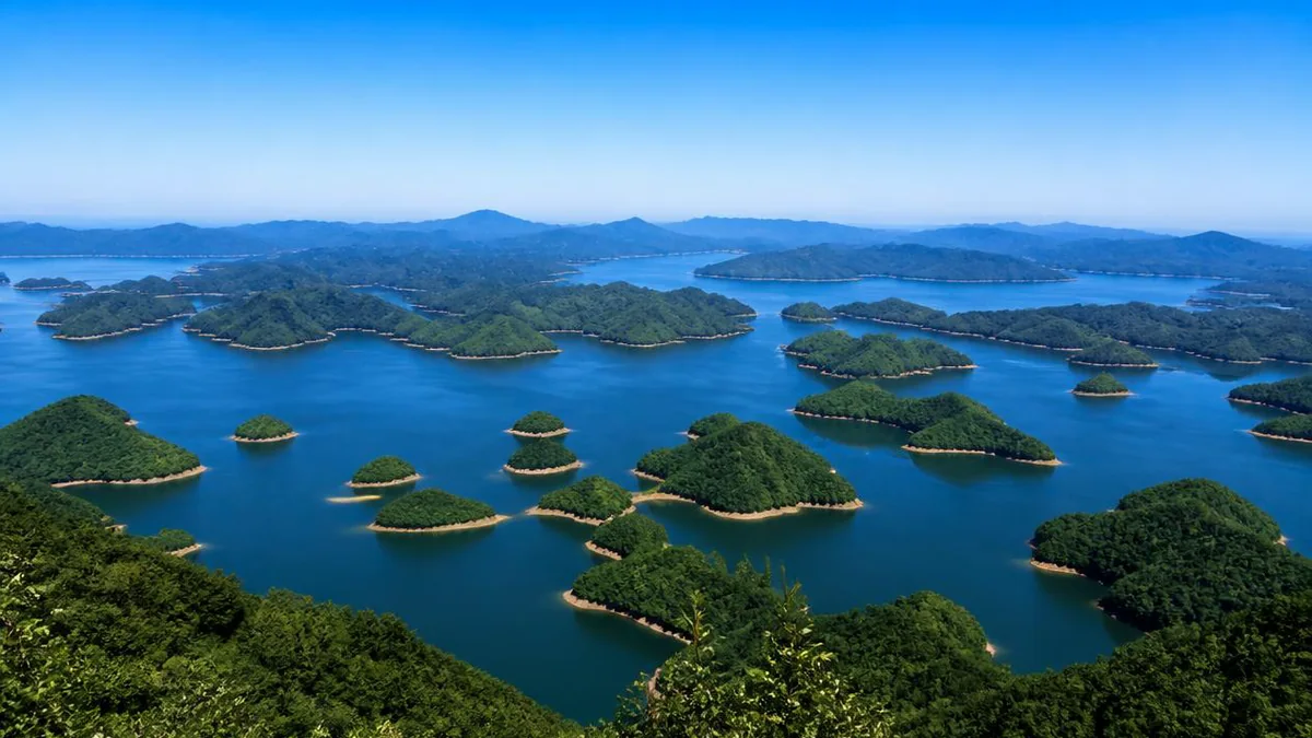
The islands are not islands. They are hilltops left uncovered when a valley in western Zhejiang was deliberately flooded in 1959 — and in the drowned country between them sit two former county capitals: one demolished first, one that ran out of time and is still standing, walls, gates and arches, twenty to sixty metres down.
5A View location, maps and nearby scenic areasThe lake in western Zhejiang that English-language travel writing calls Thousand Island Lake has 1,078 islands, and that figure is not a rounding of anything. It is the output of a rule.
The rule: when the reservoir behind the Xin’an River dam stands at its normal high level of 108 metres above sea level, every piece of land still above water measuring 2,500 square metres or more counts as an island. Apply that and you get 1,078. Below the cut-off there are thousands more, uncounted.
Which tells you what the islands are. They did not rise out of anything. They are hilltops — the parts of a landscape of low mountains that the water did not quite reach when the valley was flooded in the autumn of 1959.
And the reason to come here is not on any of them. It is in the drowned country in between, where two former county capitals are sitting on the bottom.
The name is younger than the lake
The water arrived in September 1959. The name Qiandao Hu — Thousand Island Lake — was not approved as the scenic area’s official name until 15 December 1984, by the Zhejiang provincial place-names committee. For twenty-five years the thing was called what it was: Xin’anjiang Shuiku, the Xin’an River Reservoir — and in hydrological documents it still is, with the lake name attached as a tourism brand.
The same rebranding is visible in the transport network: the high-speed station in Chun’an county was to be called Chun’an, but the county lobbied for four years to have it named Qiandaohu instead, and won. It opened on 25 December 2018.
The geography, as usual, depends on which document you are holding.
- Surface area: 567.40 km² in the Zhejiang surveying bureau’s figures; 573 km² in English reference works; 580 km² in the reservoir’s own technical specification at the 108-metre level
- Mean depth 34 metres by one account, 26 by another; maximum depth 97 metres by one account, 120 by another
- Storage 17.84 km³ at normal high level, around 22 km³ total capacity
- Catchment above the dam 10,442 km²
The forest figures are less ambiguous and more interesting. The original evergreen broadleaf cover was wrecked during construction. Chun’an now reports forest cover of 77.88% county-wide and 82.5% within the lake area — but most is regrowth and planting since the reservoir, dominated by masson pine. The green hills in every photograph of this lake are about sixty years old.
Two cities, and what they were
The valley was not empty. It held two county seats, and both of them were old.
Hecheng — literally He’s city — was built in 209 CE by He Qi (died 227), a general of the Eastern Wu state, the period Western readers meet through the Three Kingdoms stories. He had just put down the Shanyue peoples in these hills, and built a walled seat for the new commandery carved out for him to govern. It was a prefectural capital until 697, when the prefecture moved downriver, and a county seat from then until 1959 — roughly seventeen and a half centuries of administrative continuity.
Shicheng — Lion City — was the seat of the neighbouring county of Sui’an, established the year before, in 208 CE, and renamed Sui’an in 280. The seat moved below Wushi Shan, Five Lion Mountain, in 621 and stayed, taking its name from the mountain at its back. When Chinese state radio described Shicheng in 2011 it gave the city’s age as 1,339 years — 621 counted forward to 1959, the arithmetic of a place demolished at a precise age.
Two things happened in this valley worth knowing before you look at the water.
The first is a rebellion. In 1120 a hired labourer turned Manichaean religious leader named Fang La raised a revolt here against the Northern Song court, serious enough to shake the dynasty and famous enough to supply the final campaign of Water Margin, one of the four great classic Chinese novels; he was killed in 1121. The court renamed the county in response — Qingxi to Chunhua, and in 1131 to Chun’an, roughly simple, and easily settled. The name is a punishment for a nine-hundred-year-old rebellion, and it is still on the map.
The second is a magistrate, and he shows you how to read the rest of this.
Hai Rui (1514–1587) is the nearest thing imperial China has to a household name for judicial incorruptibility — the official whose entire reputation is that he could not be bought. Made magistrate of Chun’an in 1558, he re-measured the land so labour obligations fell evenly, sent his superiors nothing but rice wine, and cut the charges levied beyond the formal tax. Then a salt-inspection censor passed through, decided the hospitality was insulting, and had him impeached.
There is also a famous story. Late Ming notebooks record that the son of the regional supreme commander Hu Zongxian horsewhipped the staff of Chun’an’s post station, whereupon Hai Rui announced the young man was obviously an impostor — no son of Commander Hu would behave so badly — and impounded the silver he was carrying. The official History of the Ming put the anecdote into Hai Rui’s biography, about as authoritative as Chinese historiography gets. Roughly sixty years later an official named Huang Bingshi went to check. Chun’an had no post station at all, nobody had heard the story, and Hai Rui himself had written that the county had no post relay. Huang concluded it was invented, and that later generations had a habit of attaching improbably upright deeds to Hai Rui’s name.
The anecdote is in the dynastic history. It is also, on the evidence, false. Both statements are true at once — and one island on this lake carries a shrine to the man.
Building the dam
The ambition predates the People’s Republic: in November 1947 a seven-man survey team walked the upper Qiantang River looking at dam sites and proposed a three-stage scheme. One stage was built, and it was big for its moment — described by Chun’an county as the first large hydropower station in China designed, equipped and constructed entirely by Chinese hands.
- June 1956: preliminary design completed; the project enters the First Five-Year Plan as a key national item
- 20 August 1956: preparatory works begin — the Hangzhou–Chun’an road rebuilt, an access road cut to the dam site
- April 1957: main works begin
- 21 September 1959: the river is closed off and the reservoir starts to fill
- 22 April 1960: the first 72.5 MW turbine generates
- 22 October 1977: the last of nine turbines enters service, eighteen years after the water arrived
The dam is a concrete wide-joint gravity dam in Tongguan Gorge, on the Chun’an–Jiande boundary. Maximum height 105 metres — the first in China to pass 100. Crest length is given as either 466.5 or 465.4 metres depending on the document, with nine surface spillway gates in the riverbed section.
Installed capacity is where the sources part company. English-language references give 845 MW, sourced to a blog that no longer exists. Chinese sources give 662.5 MW and show their working: four units of 75 MW and five of 72.5, which comes to exactly 662.5. Where one figure is arithmetically reconstructable and the other is not, take the reconstructable one.
One more detail belongs in the record. Dam block 23 was poured with low-quality cement to save money under the pressure of the Great Leap Forward, which Chinese accounts describe plainly as having planted a latent failure risk in the structure. The dam has held for sixty-six years. It also has that in it.
289,951, and what the county paid
Here is the number the islands are made of.
The flooded zone took in parts of four counties across two provinces, and two county seats went under. 289,951 people were moved off their land and resettled across more than fifty counties in three provinces — Zhejiang, Anhui and Jiangxi, the last alone taking some 102,000. Chun’an’s government rounds it to 290,000 sent away, plus 80,000 resettled locally on higher ground.
The rest of the inventory, as published: 1,377 natural villages and 270,268 rooms of housing; 307,838 mu of cultivated land — about 205 km², and the good flat kind, because that is what a valley floor is; two county seats, five market towns and 255 enterprises moved out.
The count of administrative units in between is not stable even within a single reference work — 8 towns and 39 townships in one passage, 27 in another, 49 townships in a third. The village figure of 1,377 is constant across all of them, and so is 289,951, a number precise to the individual, which in a resettlement of that scale is itself informative.
Sui’an County was abolished and merged into Chun’an so that one administration could handle the resettlement. Sources put the merger in October 1958; the county government’s own introduction says 1959. Either way the county died at about the time its capital drowned. Chun’an’s new seat was built at Pailing, on high ground — today’s Qiandaohu town, a county capital on a hilltop because the old one is underwater. Most of Shicheng’s residents were put down at Jiangjia, five kilometres north.
The aftermath is not usually part of the tourist story, and the county states it flatly on its own website. The reservoir took the farmland, the towns and most of the infrastructure, leaving twelve kilometres of dead-end road. Chun’an went from a first-grade county to a poor one, and its development ran through “ten years of regression, ten years of stagnation, ten years of recovery” — reaching pre-reservoir levels again only in 1977, the year the ninth turbine came online.
Why one city survived and the other did not
This is what makes Qiandao Lake different from every other reservoir with a drowned-village story.
Before a reservoir fills, the bed is cleared: buildings knocked down, timber salvaged, anything that could float free or foul a shipping channel removed. At Hecheng the clearance was carried out and the city substantially levelled. The older and more important of the two — the Three Kingdoms foundation, the former prefectural capital — is the one that was properly demolished.
At Shicheng the water rose faster than expected. The evacuation was rushed, transport short, the political pressure of the Great Leap Forward on. Chinese accounts state it plainly: beyond a few pieces of furniture and the tools of their trade, many migrants took essentially nothing. There was no time to move the city’s monuments and none to finish clearing the bed.
So the walls stayed up, and most of the houses. Clearance had been heavier in the south and lighter in the north, which is why the north end is the better-preserved end.
A careful clearance produced a demolished city. A failure of logistics produced the best-preserved drowned imperial city in China. Nobody intended the second.
What Shicheng looked like, above water
The city sat with Five Lion Mountain at its back — five hills crouched like lions — and the Wuqiang Creek in front.
The wall came late, built in 1513 by the magistrate Rong Jiuxiao after a regional insurrection spilled into Sui’an, and extended north in 1574 by the magistrate Wu Huiqian, who carried it up the slopes of the mountain. It was repaired in 1883 and again in 1935.
- Perimeter 778 zhang — about 2,570 metres; walled area about 0.43 km²
- Nominal height 24 chi; the ground being uneven, actually 7 to 9 metres, with gate towers around 10
- Squared stone below, fired brick above
- Five land gates and three water gates. The five, all towered: Xingwen east, Xiangming south, Kangfu at the little west gate, Jingwu at the great west gate, Gongji north
Five gates rather than the standard four is the detail Western coverage seizes on, and it is real: two of them face west.
Inside were East, South, West, North, Straight and Cross streets, paved with stone slabs down the centre and river cobbles at the sides. The county office sat north-west of centre, rebuilt in 1868; the county school and Confucian temple a hundred paces west, founded in the Northern Song and moved there after a fire in 1193. In front of it lay Wenlin Lake, a rectangular lotus pond about 400 metres long, dug in 1585. In 1956 the town held 1,347 households and 5,371 people.
One number needs care. Every English-language account says Shicheng’s streets contain 265 archways. That figure comes from the Sui’an county gazetteer, whose phrasing is that 265 arches lie submerged under Qiandao Lake — a count for the whole drowned county. The detailed description of the city gives 21 memorial arches standing inside the walls at the time of flooding. The two figures are not contradictory; they count different things. But they are quoted interchangeably, and a reader who takes 265 as the number inside two and a half kilometres of wall will arrive expecting something the site cannot deliver.
The sixth dive
Nobody looked for forty-two years.
In July 2001 the scenic area’s tourism administration commissioned a diving club to find the city. On the sixth dive, on 17 September 2001, they found the wall.
From that September through July 2002 the administration ran an eleven-month survey, and its conclusion made the site famous: the layout of the city, inside and outside the walls, was unchanged. Roof frames, beams and tiled roofs were still there, and in some rooms the furniture still stood where it had been left.
The depths follow from the topography — the city ran high in the north and low in the south. The northern part lies under roughly 20 to 30 metres of water, the southern under 50 to 60. English references usually compress this to 26–40 metres; the BBC’s 2014 piece rounded it to 40. Water temperature stays between about 10 and 20 °C year round.
Then it became a story. Across 2009 and 2010 the underwater photographer Wu Lixin dived the site repeatedly, and his images ran in the February 2011 issue of Chinese National Geography. That issue is the reason you have heard of this place: within weeks it was a national talking point, and a documentary shot on a return expedition aired that July.
Five days with a robot
From 27 April to 1 May 2012 a survey team went over the city with a remotely operated vehicle and underwater cameras, broadcast live on provincial and national television. The day-by-day account is the most concrete inventory of the site that exists, and what makes it valuable is how much of it is negative findings.
Day one: the north gate. The team found the gate, the adjacent walls and surrounding building remains — uneven, with long stretches of broken masonry, because tall structures near the shipping channel had been pulled down during clearance. About 30 metres inside, at a depth of around 24 metres, stood a memorial arch erected for a widow of the Wang family in 1777: three tiers of brick and stone, four pillars, three bays, completely intact.
Day two: the little west gate, well preserved, with a small stone arch bridge about 50 metres away. A temple said to stand nearby, commemorating a Tang official killed driving off raiders, was not found. Day three: the east gate, and an arch put up for a local worthy around the Ming–Qing transition — pulled over during clearance, its components lying in a pile.
Day four: the south gate and the great west gate. The great west gate had collapsed before the reservoir filled; only wall and gate tunnel remain, and the survey could not locate where the tower had stood. Inside, in the Confucian school quarter, they found a mass of arch components and the lotus-carved balustrade of Wenlin Lake. Outside the south gate, bridge piers — but no trace of the flood dyke recorded there.
Day five: the Confucian temple. Dressed stone, wrecked buildings, carved members — and, in front of the temple, the dragon juniper that had been planted upside down.
Leave it, raise it, or tunnel under it
There is a live argument about what to do with the city, and the least dramatic position is winning.
The maximalist proposals are real. Because the station’s generating role is largely spent and it now serves the East China grid as a standby plant, some have argued for lowering the lake by 30 metres and letting the city out into the air. Others would lift it wholesale and rebuild it on land.
Most specialists say leave it exactly as it is, and the reasoning is material rather than sentimental. Timber immersed in still water and cut off from air stays stable; take it out and it shrinks, dries and warps, and there is no mature technology for conserving long-submerged wood. The case against complacency is equally physical: the walls were bonded with mud and lime, binders that leach under immersion, so a strong enough current could bring sections down.
What is actually in place is a marked zone southeast of Wushi Island — 1,000 metres by 900, buoyed and signed, boats, fishing and dredging prohibited inside. In January 2011 the site joined Zhejiang’s provincial protected monuments as Shicheng Underwater Ancient City, dated Ming and Qing; the dam went onto the same list that month, as a modern historic structure.
And then there is the elegant option, on the table a very long time. A submerged floating tunnel — an Archimedes bridge, a tube held in mid-water by its own buoyancy against tethers anchored to the bed — would let visitors walk out under the lake and look at the city through glass. A Sino-Italian effort on the technology began in 1998, and in 2005 Qiandao Lake was chosen for a 100-metre prototype, the first anywhere. It has been forthcoming for over two decades: a plan, not a fixture.
Above water: a museum, a replica, and one man’s maps
Two things exist above water for non-divers, and one is genuinely moving.
The Shicheng Museum opened in October 2011 at Jiangjia town, where the city’s residents were put, covering the city’s appearance, its local life and the resettlement itself. In 2016 a full-scale reconstruction of the drowned town opened nearby as a scenic area.
The other is not an institution. Yu Nianchun, a retired local man, worked out on his own time where everything had been: walking the migrant neighbourhoods, interviewing former residents, reconstructing layouts from memory. In 2005 he published four hand-drawn maps — plans of the old Chun’an seat at Hecheng and of Shicheng, a map of the drowned villages, and a hydrological map of the two counties. Since 2007 they have been held in the Chun’an County Archives.
For Hecheng especially, which was levelled and of which very little survives underwater, an amateur’s memory map drawn forty-six years after the flood is a substantial part of the surviving record.
The water became the product
The thing that destroyed the county has become its main asset, which explains the aggressive conservation.
The lake holds over 17 billion cubic metres of water that Chun’an reports at Class I on China’s surface-water scale, with visibility beyond 10 metres. Nongfu Spring, now the dominant bottled-water brand in China, was founded in September 1996 and launched its first packaged water the next year, sourced from this lake. Beer and whisky operations followed it in.
The fishery is real industry rather than decoration: 83 fish species across 13 families, annual wild output above 3,000 tonnes, and a stocking model that puts in silver and bighead carp specifically because filter feeders clean the water. Since the mid-2000s the lake has also held pens of around 30,000 sturgeon producing caviar for the Kaluga Queen label, on the argument that fish in still water do not fight a current, grow fattier and give richer roe. A meaningful share of the world’s farmed caviar now comes from a Chinese hydroelectric reservoir.
Since 2019 the lake is also Hangzhou’s drinking water, a second-source project begun in December 2014 piping it east to a reservoir in Yuhang. Several million people downstream now have a direct interest in what happens in Chun’an.
31 March 1994
One event on this lake is better known outside China than the drowned cities, and leaving it out would be dishonest.
On 31 March 1994 a tour boat named the Hairui — after the magistrate — was carrying 24 Taiwanese tourists, with mainland crew and guides. Three men boarded, robbed the passengers, forced everyone into the hold and set the boat alight. All 32 people aboard died: 24 from Taiwan, six crew, two guides. The boat was found burning the next morning.
The three were arrested within a fortnight and executed in June; sources differ on the exact dates by a few days. The handling of the case — the initial framing of it as a fire, the refusal to let families view the bodies or the autopsy reports, the decision to cremate the remains in a neighbouring county — turned a criminal matter into a diplomatic one, and Taiwan suspended cross-strait exchanges and tour travel in response.
It is not a reason to avoid the lake. It is part of the record, and one reason the name reads differently to a Taiwanese visitor than to anyone else.
Visiting
The lake became a 5A scenic area in 2010, having already been in the very first batch of national scenic areas, on 8 November 1982, under the joint name Fuchun River–Xin’an River.
The standard visit is a boat circuit of the central islands — half a day to a full day, a themed island or two, a viewpoint, a fish-head soup lunch, engineered for volume as 5A sites are. The underwater city is not part of it: that lies in the southwest district, inside the marked exclusion zone, and the land-based way to meet it is the museum and the reconstruction at Jiangjia.
Water levels move a lot — the record high was 108.43 metres on 8 July 2020, when the dam opened all nine spillway gates for the first time — and the plum rains from late May into July are when that happens. Late spring and autumn are the seasons to want.
Two things to hold at once, and they do not resolve.
The first is that this is a well-run, heavily commercialised lake resort with a rail station named after its own brand, a bottled-water plant, a caviar farm and a pipeline to Hangzhou’s taps — a landscape whose entire visible surface, forest included, is younger than most of its visitors.
The second is that it was made by moving 289,951 people off land their families had farmed for centuries, drowning 1,377 villages and two county capitals, and setting the county back eighteen years. The more historic capital was thoroughly demolished; the other survives almost whole, twenty metres down, because the water came up faster than the trucks could be found. The best-preserved imperial city in China is an accident of a schedule that slipped.
The LoreLens app can identify the gates, arches and temple remains of Shicheng from the museum displays and the rebuilt town at Jiangjia, and explain what each building was for, in your own language, offline.
Location profile
Where it is

Frequently asked questions
Can you actually dive to the underwater city?
Not as a normal tourist activity. Chun'an county has drawn a buoyed protection zone of 1,000 by 900 metres around the site, inside which boats, fishing and dredging are banned. Dives have historically been run by a handful of clubs for divers already qualified in deep and night diving, because the ruins are not fully mapped and the southern half of the city sits at 50 to 60 metres. Access has changed more than once as the provincial heritage listing was enforced, so confirm the current position locally.
What does the Qiandao Lake 5A area actually include?
It is a lake, not a walled site, so the designation covers a boat circuit rather than a gate. Of the five districts the lake is described in, only the centre and southeast are commercially developed. That is where the cruise piers, the cable car up Meifeng and the themed islands are: Monkey, Snake, Bird and Lock Islands, and Longshan with its shrine to the Ming magistrate Hai Rui. The drowned city lies in the southwest district, 40 kilometres away, and is not on the circuit.
Is the drowned city really perfectly preserved?
Partly, and the qualifications matter. Timber sealed under still water away from air stays remarkably stable, and the 2001 survey found roof frames, beams and furniture still in position. But the bed was partly cleared before the water came, and tall structures near the shipping channel were pulled down deliberately, so the walls are uneven and some arches were found as heaps of components. Clearance was heavier in the south than the north — which is why almost every published photograph is of the north gate.
When is the best time to go?
Late spring and autumn. The problem season is the plum rains, late May into July, when the lake fills fast: on 8 July 2020 it hit its record 108.43 metres and the dam opened all nine spillway gates for the first time. Summer is hot and crowded; winter is quiet, with the water at its clearest. Where dive seasons have operated they run roughly April to November.
How do you get there, and how long do you need?
High-speed rail is the easy answer: Qiandaohu station opened on 25 December 2018 on the Hangzhou–Huangshan line, though it sits some way outside the county town, so budget for a taxi. Buses run from Hangzhou's west bus station; the drive is about 150 kilometres. Two days is the honest minimum for a full lake cruise plus the Shicheng museum and the rebuilt town at Jiangjia, on the opposite side of the water from the main piers.