Guangdong · Guangzhou
The Pearl River Cruise: The Bank That Kept Moving
The reach the boats work is a record of a shoreline being pushed at a river. Two thousand years of foreign trade happened along it, each licensed quarter set a little further out onto the water, and the rock the river is named after now lies under a road.
Almost everything in central Guangzhou is named after a rock that is no longer visible.
The Haizhu Stone was a reef in the middle of the channel: red sandstone and conglomerate, roughly 100 metres long and 50 wide, worn round by the current, rising and falling with the tide. It gave its name to the river, and the river then gave its name to a basin of over 400,000 square kilometres. Haizhu Bridge, Haizhu Square, Haizhu Road and Haizhu district all take their name from the same rock. In 1931 it was buried under a road embankment.
That is the shape of this river’s relationship with the city, and a boat is the only way to see it. The bank kept moving out into the water, and the licensed foreign trade quarter kept being moved along it.
The rock that named the river
Take the naming chain in order; it runs the wrong way round.
The stone was a navigation mark on the main channel. In the Southern Han period a temple was built on it; Su Dongpo climbed it and left a poem; a battery went up in 1646, was destroyed by British forces in the Second Opium War and repaired in 1888. In 1925 the city’s first mayor, planning a park system, made it Guangzhou’s third public park; Haizhu Park opened on 4 July 1926 and drew over 100,000 visitors in its first month.
In 1931 the commercial waterfront was extended and the channel between the rock and the north bank — about 30 metres of water — was filled in. The stone went underground, the park was dismantled and the new land became the road now called Yanjiang West Road.
In January 2000 a sewer trench struck it. A plan to expose 30 to 60 metres under a glass walkway was not carried out; a section near the Xindi Erheng Road junction was preserved and inscribed, with a sculpture unveiled beside it on 14 January 2016.
Where the river’s name comes from is not fully settled. Chinese sources derive it from the stone, which has the corroboration of that whole family of place names; English reference material says instead that it comes from pearl-coloured shells in the riverbed, for which no source was findable here. What is documented is the earliest attested use of the name, around 1558, in a poem by the Ming scholar Huang Zuo.
What the name covers now
The name has expanded twice, and it is worth knowing which river people mean.
Narrowly, the Pearl River was only the reach from Guangzhou to the sea — about 96 kilometres, or the 70-odd from Baietan down to Humen. Then in 1937 the Nanjing government created a Pearl River water conservancy bureau to manage southern China’s river network as one system, and applied the name collectively to the West, North and East rivers and the delta channels. In 1985 the river commission fixed the official source on a mountain in eastern Yunnan.
The West and North rivers meet in Foshan; the East drains separately; the delta discharges through eight mouths. Annual runoff is about 341 billion cubic metres, of which the West River supplies roughly 80 per cent — second in China only to the Yangtze, and about four times the Yellow River.
Length and rank disagree between sources for a knowable reason. Chinese material gives the trunk as 2,214 kilometres, fourth-longest in China; English material, measuring from the furthest headwaters of the West River through a chain of renamed reaches, gives 2,400 and third. That is where you start counting, not a dispute.
One local usage tells you what the river used to feel like. Guangzhou people call it hoi, the sea. Crossing is “crossing the sea”; the bank is “the sea’s skin.” The words survive from a time when the channel was wide enough to justify them.
Arriving by water for two thousand years
The trade is older than any building you will pass, and it was always seaborne.
Guangzhou was working as a foreign trade port by the second century BC, and is described as one of the starting points of the maritime silk route. Under the Tang, the sailing route out of Guangzhou was reckoned the longest ocean route in the world of its day.
By the ninth century there was a designated foreign quarter — the fanfang — south of the city wall on the north bank, around what is now Guangta Street, occupied largely by Arab and Persian merchants. The interesting part is how it was run: the court appointed a headman from among the residents to settle disputes between foreign merchants and to recruit more of them, and Tang law allowed foreigners a defined degree of self-adjudication under their own customs. The Huaisheng Mosque dates from that quarter, and an Arab merchant, Sulaiman, described the arrangement in a travel account of 851.
Its history is not smooth. Guangzhou was sacked at the end of the Tang and foreign merchants killed in numbers; the quarter declined, revived under the Song, and lasted into the Yuan, when Ibn Battuta recorded a mosque, a judge and a sheikh there. The early Ming sea ban closed it. Whether the fanfang was an ancestor of the nineteenth-century concessions is actively argued among historians, and is not resolved here.
One port, and a row of factories set back from the water
The best-known chapter is also the one whose geography is most often got wrong.
In 1684 the Qing opened maritime trade and established customs offices in four coastal provinces. The Guangdong customs, the Yuehaiguan, was set up in 1685 with its provincial office at Tianzi Pier and a duty station at Whampoa downstream. From 1686 foreign merchants could rent quarters and trade in a district by the river in the western suburbs. In 1757 the Qianlong emperor closed the other customs offices, and from then until the Treaty of Nanking in 1842 Guangzhou was the single legal port for Western trade — the Canton System. In 1760 ten hong merchants were licensed as a monopoly body, the Cohong; “Thirteen” is conventional, and the real number moved — sixteen in 1720, twenty-six in 1751.
Now the geography. The Thirteen Factories were warehouses, offices and lodgings standing roughly three hundred feet back from the water, and foreign ships were forbidden to moor along the river at all: they anchored at Whampoa, with cargo lightered up in “chop boats.” Traders arrived on the summer monsoon, left between November and February, and withdrew to Macao in between. They dealt with officials only through the hongs, could not bring wives to Guangzhou and were not to study Chinese.
None of that is a moral verdict; it is the licensing regime, and it explains the shoreline. The state’s method was to keep foreign trade at a fixed, watched distance from the water — and the traders off it.
The district burned three times: accidentally in 1822, when the loss was put at forty million taels of silver; in 1841, during the First Opium War; and in December 1856, at the opening of the Second, when it was burned out entirely. It was never rebuilt on that site, which is now part of Guangzhou Cultural Park.
Shamian: a sandbank turned into a leasehold
After 1856 the foreign quarter moved, and where it moved is the reason Shamian looks the way it does from the water.
The first attempt was on the south bank, opposite the old factory site. In 1843 the British sought a few dozen mu there; the Qing court raised no objection, but local gentry assembled a mass opposition — Chinese accounts describe forty-eight villages and over two thousand people — and the British withdrew the request.
The second attempt succeeded because it took ground nobody lived on. In 1859 Britain and France asked the Guangdong authorities for Shamian and for Xihao; Xihao was refused because too many people lived there, and the official waterside land at Shamian was granted. A creek, the Shajichong, separated it from the bank, and the sandbank was filled and embanked into an island of roughly 900 by 300 metres, about 55 acres. The concession treaty was signed in July 1861.
The division of the island is genuinely disputed. Chinese sources give the western four-fifths to Britain and the eastern fifth to France, with the boundary at what is now Shamian First Street; English sources give three-fifths and two-fifths. They cannot both be right.
From the boat you do not see buildings so much as a frontage: a low, even line of masonry behind old trees, which is the point. The island holds over a thousand trees, 137 of them more than a century old; two mass planting campaigns in 1864 and 1878 produced most of what you see. Along the south edge were four stone landing steps, of which three were destroyed by land reclamation in the 1980s when the White Swan Hotel was built. One survives. The building group was designated a national heritage site in 1996.
One more thing is visible from the water without any interpretation, and it is a name. The road on the mainland side of the creek is called June 23 Road, after 23 June 1925, when British and French troops fired on a demonstration passing along that bank. Accounts of the sequence and the responsibility differ sharply between the Guangzhou government of the day and the concession authorities, and casualty figures remain contested. The road name records the date and nothing else.
Where you board, and what those piers were
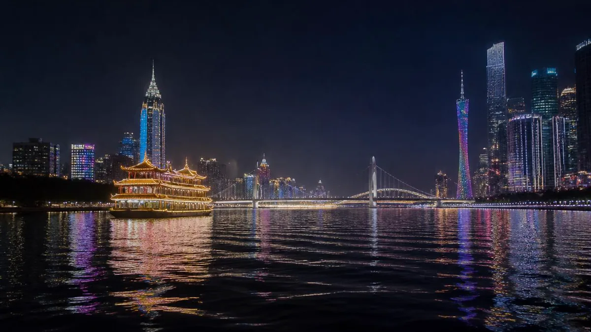
The cruise as a product has a precise and unromantic origin. The provincial shipping company, losing its river passenger traffic to city buses, set out from the late 1990s to develop water tourism, and in 2000 launched the Pearl River night cruise alongside the municipal image and night-lighting programmes. The lit banks and the boats were designed together.
The wharves are much older than the product. Tianzi Pier is the oldest in continuous use, formed in the Yongzheng reign, 1723 to 1735, and described as having been set up to receive officials from Beijing — with the customs office next to it, which is the institutional half of the story. Huangsha, the Canton Tower and Zhongda landing, Haixinsha West and a wharf at Haizhu Square are also in use; Dashatou and Xidi appear in some listings.
Which one appears on a ticket changes by season and by day. Confirm it before crossing the city.
The reach the boats work
The channel has a shape, and the shape is the argument.
The reach inside the city is the front channel: 22.82 kilometres from Baietan in the west, along the north edge of Haizhu district, to the eastern end past Changzhou Island. Chinese descriptions say plainly what has happened to it. Successive city walls and municipal works ate into the riverbed until the channel became a dumbbell, wide at both ends and pinched in the middle. Shoreline rehabilitation between 1994 and 2006 tidied the banks and made the night cruise viable. Water quality here has been recorded as failing standards year-round, with improvement noted recently.
Baietan, at the west end beside Shamian, is the widest and deepest water the river reaches in Guangzhou, where the west, front and rear channels meet. It became an anchorage for foreign warships after Shamian was leased, and boat-dwelling families still lived on it into the 1950s, when a state housing programme moved them ashore.
The islands in the channel are Shamian, Ersha and Haixinsha, and one of them makes the tidal point for you. Haixinsha, opposite Canton Tower, was a flat that emerged only at low water; silting and reclamation roughly doubled it before it was rebuilt for the 2010 Asian Games opening ceremony. The Haizhu Stone rose and fell with the same tide. This is an estuarine river, not a lake with a promenade.
The bridge that was blown up
Bridges read as lines from the bank and as structures from beneath, and one of these is worth the trip on its own.
Haizhu Bridge was the first bridge across the river in Guangzhou. Built from 1 December 1929 and opened at one in the afternoon on 15 February 1933, it was 356.67 metres long with a main span of 182.9, a width of 18.3, and eight metres of clearance above the waterline. The middle of the deck could be raised to let ships through — the only openable iron bridge in China at the time. The contract went to Andersen, Meyer & Co.; the name came from the Haizhu Stone, then still above water a short distance upstream.
Then the machinery went. In June 1938 Japanese bombing wrecked the opening gear — one account instead attributes part of the damage to retreating Chinese troops — and the equipment was removed entirely. On the evening of 14 October 1949, retreating Nationalist forces blew the bridge up; over four hundred people were killed or injured, with heavy casualties among the boat families beneath. Reconstruction ran from 25 March 1950 under Soviet bridge advisers and took six months; the bridge reopened on 7 November 1950 at 486 metres and 33 metres wide, with no opening function.
Three decades of bridge, in order
Two afterthoughts before you pass under it. The 1950 rebuild used salvaged steel from a demolished British bridge, and decades later the British supplier faxed Guangzhou to say the material was nearing the end of its service life — part of why the bridge closed for eighteen months from 28 February 2012. And the cables and towers added in 1995 for strengthening, removed in that overhaul, are routinely mistaken for surviving parts of the opening mechanism. The centre span had been a plain steel truss since 1950.
Downstream, Guangzhou Bridge was the city’s third river crossing: built from April 1983, opened 10 June 1985 at 988.4 metres with 8.7 metres of main-channel clearance, then twinned between 2014 and 2017 to ten lanes. Liede Bridge, further east, is a single-tower self-anchored suspension bridge with a 480-metre main span, begun in 2006 and partially opened on 30 July 2009.
The three are the 1930s, the 1980s and the 2000s in order, and each sat at the eastern edge of the city as it stood when it was built. From the water you read them as a ruler.
The bank that kept moving
Come back to the rock, because by now it should read as a summary rather than a curiosity.
Sail this reach from west to east and the licensed edge of Guangzhou’s foreign trade moves with you, and forward in time: the fanfang inside the old city; the Thirteen Factories set back from the water with the ships held downstream at Whampoa; a refused request on the south bank in 1843; a sandbank filled into an island and leased in 1861; an embankment in 1931 that swallowed the rock the river was named for; a hotel in the 1980s that took three of Shamian’s four landing steps; a tidal flat rebuilt into a ceremonial island in 2010; and a 600-metre tower on the far bank, described in the Canton Tower guide.
Every one of those moves pushed the shoreline further out, or shifted the trade quarter along it. The only part nobody could build on is the part you are sitting in, which is why the sequence is legible from a boat and nowhere else.
The LoreLens app can identify bridges, wharves and waterfront buildings from the deck and explain their dates and functions as you pass.
Location profile
Where it is

Frequently asked questions
Which stretch does a cruise cover, and where do the boats leave from?
The sightseeing run works the front channel, the reach of the river inside the city, which is about 22.8 kilometres from Baietan in the west to the eastern end at Changzhou Island. Boats do not use all of it. The usual range is described as running between Renmin Bridge, at the western end near Shamian, and Canton Tower or Liede Bridge in the east, turning back at one of them — so a west-to-east sailing goes from the old foreign quarter to the new central axis. Be careful with published route diagrams: at least one widely copied Chinese description has the compass directions reversed, which makes it useless for working out what you will pass first. Wharves in current or recent use include Tianzi, Huangsha, the Canton Tower and Zhongda landing, Haixinsha West and the one at Haizhu Square; Dashatou and Xidi appear in some listings. Which wharf your ticket uses, how long the sailing runs and where it turns all change with the operator, the season and river traffic. Confirm on the day rather than from any diagram, this one included.
Was Tianzi Pier really where Qing officials came ashore?
Yes, and the claim is better supported than most pier folklore. Tianzi Pier took shape during the Yongzheng reign, between 1723 and 1735, and Chinese sources describe it as having been set up specifically to receive and see off officials arriving from Beijing; the nearby Jieguanting, the pavilion for greeting officials, survives as a lane name off Beijing South Road. It is also the oldest continuously used wharf in Guangzhou. There is a stronger institutional fact behind the story: when the Qing set up the Guangdong maritime customs, the Yuehaiguan, its provincial office was established at Tianzi Pier in 1685. So this was not just where officials happened to land, it was where the customs administration sat. Lin Zexu came ashore here in 1839 to begin his opium suppression campaign, and Sun Yat-sen is recorded boarding here to escape to Hong Kong. Less often mentioned: there was an execution ground just north of the pier, and the street name that records it is still on the map.
Is the night cruise worth it, or is daytime better?
They show different things. Night gives you the facade lighting on both banks and the towers of the new axis, and almost nothing of the river itself. Day gives you the working channel, the shape of the bank, and Shamian's south frontage and stone landing steps, which are the oldest things you can see from the water and which vanish in the dark. Two things worth knowing before you book an evening sailing. First, the lighting is administered rather than ambient: hours differ between ordinary evenings, weekends and public holidays, special programmes appear on some dates and not others, and the Guangzhou International Light Festival occupies Huacheng Square each November. Second, the cruise itself was created as a city image programme, launched in 2000 alongside the municipal night-lighting project, so the lit banks are the product rather than a backdrop to it. Check the day's notice, and if the lights matter more than the river, book late rather than early.
What happened to the Haizhu Stone, the rock the river is named after?
It is under a road, and part of it is visible. The Haizhu Stone was a large Cretaceous reef of red sandstone and conglomerate in the channel, described as about 100 metres long and 50 wide, rounded by the current and rising and falling with the tide. It was a navigation mark, it carried a temple from the Southern Han period onward, and it held a battery from 1646. In 1925 the city turned it into Haizhu Park, which opened on 4 July 1926 and drew over 100,000 visitors in its first month. Then in 1931, as the embanked waterfront was extended, the roughly 30-metre channel between the rock and the north bank was filled in. The rock was buried, the park was demolished, and the new ground became the road now called Yanjiang West Road. In January 2000 a sewer trench at Yanjiang West Road accidentally struck it after nearly seventy years. A proposal to expose 30 to 60 metres of it under a glass walkway was not carried out; a section at the Xindi Erheng Road junction was preserved instead, with a sculpture unveiled beside it on 14 January 2016.
Sources and further reading
Background references for the history and place names in this guide. Opening hours, ticketing and access change often — always confirm with official local information before travelling.