Jiangsu · Lianyungang
Mount Huaguo: The Monkey King's Island, Now Attached to China
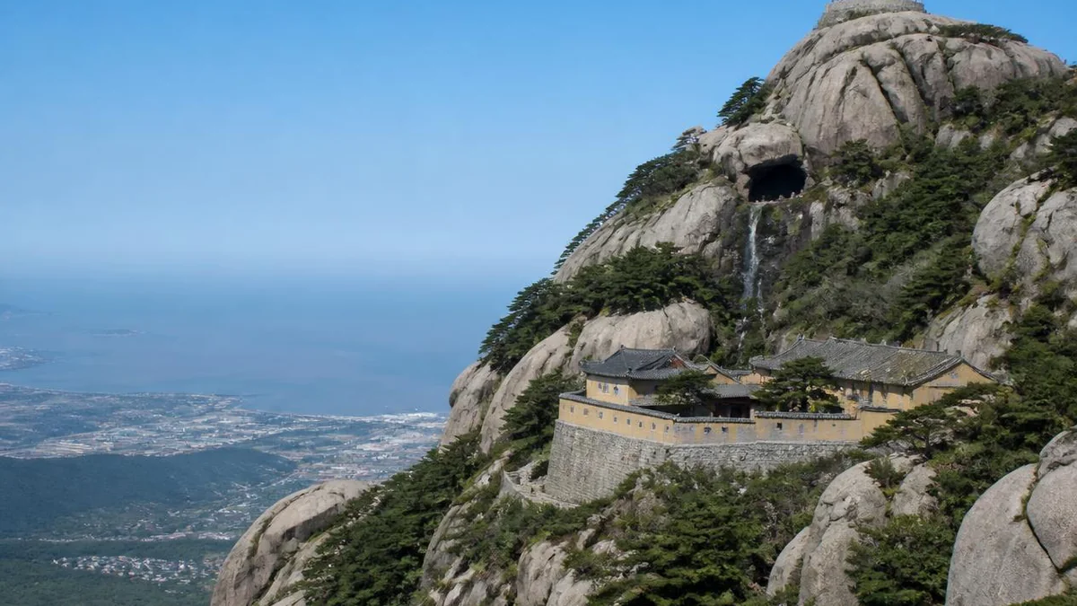
When Wu Cheng'en climbed this mountain it stood alone in the Yellow Sea, exactly as Journey to the West describes. Then the Yellow River filled in the channel and the island became a hill.
5A View location, maps and nearby scenic areasThe novel is precise about the setting, and its precision is the reason we are here.
Beyond the sea, Journey to the West says in its opening chapter, there is a country called Aolai. The country lies near a great sea, and in that sea stands a famous mountain, called Huaguo — Flower-Fruit Mountain. On its summit is a stone egg, and out of the stone egg comes a monkey.
Wu Cheng’en never says which sea or which coast. But he lived in Huai’an, about a hundred kilometres from here, and the record has him climbing this range more than once. And when he was climbing it, in the middle of the sixteenth century, the mountain he was standing on was an island in the Yellow Sea — which is precisely what his book describes and what no other candidate for Huaguo Mountain can say.
It is not an island now. You drive to it.
The island that stopped being an island
The Yuntai range — of which Mount Huaguo is the central massif of the southern block — spent most of recorded history offshore. It was called Yuzhou Mountain in antiquity, and Cangwu Mountain in the Tang and Song, and Su Shi wrote about it as a mountain on the sea, dense and green, somewhere between the real world and the isles of the immortals. Through the Ming, everything here except Jinping Hill was a chain of islands in open water.
What ended that was the Yellow River, and it was not an accident of local hydrology but the largest man-made river disaster in Chinese history. The Yellow River, breaking out of its bed and diverted south, captured the course of the Huai and reached the sea here instead of far to the north. It brought its sediment with it. The Huang-Huai delta grew year after year, and the channel between the Yuntai islands and the Haizhou mainland began to close.
The New Gazetteer of Yuntai records the sequence with unusual bluntness. In the fortieth year of Kangxi — 1701 — the crossing between Yuntai Mountain and the mainland at Haizhou was gradually silting up. By the fiftieth year — 1711 — it had suddenly become dry land.
The process continued. The five-lake basin between the northern and southern Yuntai ranges emerged as land around 1851; the middle and rear ranges joined the mainland around 1855. Only Yingyou Hill — Lian Island — remained out in the water, and it stayed an island until a 6.7-kilometre causeway, begun in 1985, opened to traffic in 1996.
So the geography that makes the novel’s setting real was destroyed about a century and a half after the novel was written, by a river three hundred kilometres away. Wu Cheng’en’s sea-girt mountain is now a hill you approach through the outskirts of a port city, and the only reason anyone knows it was ever otherwise is that a Qing county gazetteer wrote the year down.
There is something fitting in this. The book is about a journey west across a landscape that no longer exists in the form described. The mountain it starts from is in the same condition.
What Wu Cheng’en saw
The Yuntai range holds a hundred and thirty-six named hills, in a peak-and-gorge landscape cut into Triassic sandstone and Jurassic diorite porphyry. The formal designation — the Yuntai Mountain National Scenic Area, approved by the State Council in 1988 — covers 167.38 square kilometres, of which 144.73 is land and 22.65 is sea, making it the only national scenic area in Jiangsu that takes in both a mountain and the ocean. Its four advertised qualities are sea, antiquity, the supernatural, and seclusion.
Mount Huaguo has been called the finest sight of the Eastern Sea since long before the novel, and it counted as one of the four numinous mountains within the empire. Li Ruzhen, who lived in Haizhou for decades and wrote Flowers in the Mirror, made it his Lesser Penglai — an immortals’ island.
What Wu Cheng’en took from it is specific enough to be checkable. The novel’s Water Curtain Cave, the monkey posted at its gate, the Tang Monk’s Cliff, Sandy’s Stone and the seventy-two caves all have counterparts on the mountain, and the mountain’s guides will point at every one. The correspondence runs the way you would expect: the features are real, the names are the novel’s, and the naming has gone on for four hundred years.
Which is the honest way to frame this. Nobody can prove Wu Cheng’en meant this mountain. What is documented is that he was local, that he came here, that the topography fits, and that the sea he needed was still here when he was. The claim rests on convergence rather than on any single piece of evidence, and it is the strongest such claim anyone makes.
The Water Curtain Cave
The one sight everybody comes for is a cave mouth with water falling across it.
It is a genuine cavern in the cliff with a stream dropping over the entrance, so that you pass through the fall to get inside — the arrangement the novel gives the monkeys when they discover their home behind the waterfall. Inside is a chamber with water on the floor and coins thrown into it by visitors.
The rest of the mountain’s set-pieces string up the slope from there: the Nine Dragon Bridge, the Eighteen Bends of stone staircase, the Southern Heavenly Gate, the Garden of Strange Rocks, the Jade Emperor’s Pavilion, Peacock Gully, and the seventy-two caves, which are real caves and are not actually seventy-two.
There is also a museum to Wu Cheng’en himself, holding material on his life and editions of Journey to the West collected from around the world — which is a reasonable amount of shelf space, given that the book has been translated into most written languages and adapted into more television than any other Chinese novel.
Jade Maiden Peak
The summit is Jade Maiden Peak, and at 624.4 metres it is the highest ground in Jiangsu province. The figure comes off a marker stone put up there in August 2002; some sources give 625.3 metres instead, and the discrepancy is the usual one between survey datums. Either way, the point stands: Jiangsu is an extraordinarily flat province, and this modest coastal summit is the top of it.
The name has two explanations and they do not agree. The literary one is that a supplementary Yuntai gazetteer describes twin peaks, the eastern called Clear Wind and the western Jade Maiden, together forming the range’s summit — and that the Jade Maiden is a heavenly figure from Journey to the West, the novel’s thirtieth chapter placing Mount Huaguo as reaching up to the Jade Maiden’s washing basin, with carvings and remains associated with that basin still shown on the mountain’s southern side at Donglei.
The other explanation is prosaic and better documented. In the Chenghua reign of the Ming, a man describing himself as a grandson of the Prince of Lu took religious orders on this mountain under the dharma name Qingfeng — Clear Wind — and the summit was named after him, becoming Qingfeng Peak, which the modern name has since displaced.
Both stories are in circulation on the mountain. The second one has a person in it with a date attached; the first has a novel. It is not hard to see which way the tourism industry leans.
Three Primordials
The main temple is the Three Primordials Temple, and its history is more interesting than the version on the sign.
The tidy formula you will read is that it arose in the Tang, was rebuilt in the Song, received an imperial grant in the Ming and flourished in the Qing. The more careful accounts complicate this. Haizhou was indeed a centre of religious activity under the Tang and Song, but what stood on Yuntai Mountain was at most an obscure small shrine holding tablets and images of the Three Primordials; the Song gazetteers record only a hermitage called Daxian An.
The temple’s real history starts in the Ming, with the same man who named the peak. In 1467 the grandson of the Prince of Lu arrived with a begging bowl, was taken with the quiet of the landscape, raised funds to restore the hall of the Three Officials, and shaved his head as a monk under the name Qingfeng. In 1587 a man of Huai’an named Xie Chun spent his entire family fortune on expanding it, which is what put the place on the map. The temple’s gateway and the plaque reading Imperially Granted Three Primordials Temple That Protects the Realm are both Ming survivals. Inside the main hall hangs a board in the Kangxi emperor’s own hand.
Then the losses. In 1661 the temple was destroyed in the coastal clearance — the Qing policy of forcibly emptying the southeastern seaboard to starve out the Ming loyalist resistance at sea, which depopulated hundreds of kilometres of coast and is one of the least-discussed catastrophes of the dynasty’s founding. Rebuilding was petitioned for and granted in 1677, and continued through the Kangxi, Qianlong, Jiaqing and Daoguang reigns until the complex held twenty-four courtyards. By the late Qing twelve remained, known as the Twelve Houses. In 1938 Japanese bombing destroyed the Three Primordials Temple and everything attached to it.
What you walk into today was rebuilt by the Lianyungang municipal government in 1980, on Ming architectural models.
That sequence — imperial patronage, deliberate state destruction, imperial rebuilding, wartime destruction, municipal rebuilding — is a fairly complete history of Chinese religious architecture in four hundred years, compressed onto one hillside.
The pagoda that outlived the earthquake
Below the temple stands the Ashoka Pagoda of Haiqing Temple, built in the Northern Song, and it is the tallest and oldest surviving pagoda in northern Jiangsu.
A stele set into its inner wall when it was built records that an earlier pagoda stood on this spot, and that in the Tang it had been reckoned the second finest in the country. The present one has been a principal sight of Yuntai Mountain for a thousand years, listed in the Ming as Ancient Pagoda Piercing the Clouds and in the Qing, more tenderly, as The Pagoda’s Reflection Made Whole.
Its most impressive achievement is passive. In 1668 the Tancheng earthquake, magnitude around 8.5 and the strongest recorded in eastern China, struck a little over a hundred kilometres north of here. The pagoda is still standing.
Nearby are the Tang-era Yulin Temple rock inscriptions, the Bamboo Screen Chan cloister, the Righteous Monk’s Pavilion and the tea hermitage — the ordinary furniture of a mountain that has been continuously religious for a very long time, and which the Monkey King has almost entirely eclipsed.
Four hundred characters on the cliff
Above a spring on the mountain’s flank, on a south-facing rock face two metres high and five metres across, there is a Tang inscription about the view.
It is known as the Record of the Eastern Cliff Wall at Yulin Abbey, Donghai County: twenty-four lines running right to left, seventeen characters to the line, each character eighteen centimetres across, the first line in seal script and the body in clerical, 392 characters in total. What it does is describe the scenery of Yuntai Mountain. The Yulin Abbey rock inscriptions were listed in the seventh batch of nationally protected monuments in 2013, and they are among the finest calligraphy in the province, which has not stopped most visitors and a good many residents of Lianyungang from never having heard of them.
The abbey they belonged to is gone, and its ending is the same ending as everything else here. It was founded in the Sui dynasty, between 581 and 600, as a subordinate cloister for Daoist women. It fell into ruin after the early-Qing coastal clearance. When the New Gazetteer of Yuntai was compiled in 1837 there were a few thatched huts left and several dozen apricot trees; those went too. In 1903 the resident monk raised money and rebuilt it, and it was destroyed again. Nothing of the site survives but the name and the wall.
The inscription matters for a reason that has nothing to do with monkeys. It is a Tang-dynasty text praising this landscape, carved some eight centuries before Wu Cheng’en was born — and above the Water Curtain Cave itself are carvings by Wang Tong, the Ming prefect of Haizhou, reading high mountains, flowing water and the divine spring moistens all. The cave was already a named beauty spot with an official’s calligraphy on it before it was anybody’s monkey cave.
This mountain did not need the Monkey King. It got him anyway.
The monkeys are real
More than three hundred wild macaques live on this mountain, concentrated in the woods around Jade Maiden Peak.
They are not an attraction that was installed. They are a resident population on a mountain that a sixteenth-century novelist chose as the birthplace of a monkey, and the sequence of causation almost certainly runs from the monkeys to the novel rather than the other way round.
They behave like wild macaques near tourists everywhere: confident, quick, entirely willing to go into a bag, and best not fed by hand. The mountain also carries over seventeen hundred plant species, of which about 1,190 are medicinal, along with rarities for the province including golden-sheathed jade bamboo and ancient ginkgoes.
Twenty other places say it is theirs
There is no scholarly consensus that this is Wu Cheng’en’s mountain, and it is worth being clear about that before going any further.
Journey to the West is a work of supernatural fiction. Its Huaguo Mountain sits in the Aolai country of the Eastern Continent of Divine Continuation, which is not a place. Candidates advanced for a real-world prototype include this mountain, Loufan in Shanxi, Baoshan in Shunchang county, Fujian, Mount Tai in Shandong, Yiyang outside Luoyang, Yangxian at Yixing, and Siming Mountain near Ningbo. More than twenty cities have at some point publicly announced themselves the Great Sage’s hometown.
Lianyungang’s claim is the most widely accepted, and its history is more recent than the mountain’s confidence suggests. It was made by a local gazetteer scholar, Li Hongfu, in a 1978 paper on Yuntai Mountain, Wu Cheng’en and Journey to the West. It became orthodoxy at the first academic symposium on the novel, held here in 1982, where a hundred and twenty-seven scholars from twenty-two provinces and regions accepted his argument. Everything on the mountain that carries a name from the novel carries it because of a conference.
The claim has one older layer. Mao Zedong referred more than once to the Monkey King’s home mountain, and a large rock here is carved with the line that the monkey’s old home is at Yuntai Mountain in Xinhailian — a city name that has itself since disappeared, Xinhailian having become Lianyungang in the early 1960s. The stone is known locally as the Mao Stele.
The rivals are not frivolous. Shunchang has a joint tomb of the Great Sage and his brother dated to the late Yuan or early Ming, along with a Gaojia Village and a marked stone, and calls itself the Ancestral Land of the Great Sage. Loufan’s case was built over more than twenty years by scholars including Meng Fanren and Li Angang, and rests on monkey-king temples that predate the novel’s composition. Mount Tai points at its own Aolai Peak, southwest of the summit, and its own water-curtain cave — though when the claim circulated in 2024, the Tai’an tourism bureau clarified that it had merely reposted somebody else’s article. Huai’an, which has the strongest claim of all to Wu Cheng’en, since he lived and died there, has taken the different route of building out his former residence; when Lianyungang played Huai’an at football in 2025 the fixture was nicknamed the Monkey Derby.
And there is a scholarly objection to the whole exercise, made most directly by Miao Huaiming: if this quantity of matching relics is enough to establish a prototype, then dozens or hundreds of Chinese mountains qualify. The deeper problem is that the novel is fiction, not historical geography, and the attempt to land each of its place names on a real coordinate is itself a misreading of what kind of book it is.
That objection is correct, and it does not much matter to anyone selling a ticket. The scenic area has taken close to twenty million visitors over the past decade and derivative revenue in the billions of yuan. When Black Myth: Wukong shipped, Lianyungang offered free admission to players who had finished the game and Shunchang did the same, and for a few months in 2024 two counties nine hundred kilometres apart were competing for the same completion screenshots.
What the mountain has, that the argument cannot take away, is the sea it used to stand in.
What a video game did
Mount Huaguo became a 5A scenic area on 3 August 2016, with the plaque presented in Beijing on 4 November — which, remarkably, ended Lianyungang’s long run as an established tourist city with no 5A attraction at all. Yuntai Mountain had been on the state’s list of key scenic areas since 1988; the top tourism grade took another twenty-eight years.
Then, in 2024, something happened that no amount of scenic-area accreditation could have produced. Black Myth: Wukong, a Chinese action game built on Journey to the West, became a global phenomenon, and a large number of people who had never thought about Ming fiction went looking for the Monkey King’s mountain. In the first three quarters of 2024 Mount Huaguo received 4.59 million visitors, up 30.5% year on year, on tourism revenue of 349 million yuan, up 20%.
A cable car to the summit was in final commissioning as of August 2026, which will change the character of the ascent considerably and is worth checking on before you plan to walk the Eighteen Bends.
It is worth sitting with what that surge actually was. A novelist visited an island in the Yellow Sea in the 1550s. A river silted the island to the mainland in 1711. A studio in Hangzhou shipped a game in 2024. The traffic on the staircase is the result of all three, and only one of them was anybody’s plan.
Visiting
Allow a full day for the summit, half for the lower mountain. The Water Curtain Cave and the Three Primordials Temple are close together and can be done comfortably; Jade Maiden Peak is a real climb by staircase unless the cable car is running.
The mountain is a short bus ride from central Lianyungang, and Lianyungang is on the east coast rail network with high-speed connections south to Nanjing and Shanghai and north into Shandong. Spring and autumn are best. It is a coastal mountain, so expect the summit to be colder and much windier than the ticket gate, and expect cloud — the range’s old name meant cloud terrace for a reason.
Two things to hold together while you are up there. You are standing on the highest point in Jiangsu, and it is 624 metres, which tells you most of what you need to know about the province.
And the water on three sides of you, which is what made this the right mountain for a monkey to be born on an island in, has been farmland for three hundred and fifteen years.
The LoreLens app can tell you which sights on this mountain are named from the novel and which were here first — a distinction the signage tends to blur.
Location profile
Where it is

Frequently asked questions
Is this really where the Monkey King came from?
Journey to the West never names a real place — it says only that beyond the sea lies a country called Aolai, and near that country in the sea stands a famous mountain called Huaguo. The case for this being it rests on three things: Wu Cheng'en lived about a hundred kilometres away in Huai'an and is recorded as having climbed this range repeatedly; the mountain was a genuine island in the Yellow Sea when he wrote; and its actual features, including a waterfall over a cave mouth and dozens of caves, match the book. Other places make competing claims. This one has the strongest geography, and it has had scholarly backing since a 1982 symposium here accepted the case — though the identification itself dates only to a local scholar's 1978 paper, and some scholars object to the whole exercise of mapping a fantasy novel onto real coordinates.
Was Mount Huaguo really an island?
Yes, until 1711. The Yuntai range stood offshore in the Yellow Sea for most of recorded history. The Yellow River, diverted south to capture the Huai, dumped enough sediment to close the channel — the local gazetteer records the crossing silting up from 1701 and the mountain suddenly becoming dry land by 1711. The middle and rear Yuntai ranges joined the mainland around 1855.
How high is Jade Maiden Peak, and is it Jiangsu's highest point?
It is Jiangsu's highest point, at 624.4 metres according to the marker stone erected on the summit in August 2002. Some sources give 625.3 metres. Either way it is a modest summit — Jiangsu is a very flat province, and this is the highest ground in it.
Are there actually monkeys?
Yes, more than three hundred wild macaques live on the mountain, concentrated around Jade Maiden Peak. They are genuinely wild, they are used to people, and they will take food from bags. Do not feed them by hand.
How long does a visit take?
A full day if you go up to the summit, which involves the Eighteen Bends staircase or the cable car. Half a day covers the Water Curtain Cave, the Three Primordials Temple and the lower sights. Spring and autumn are best; the mountain is coastal and the summit can be considerably colder and windier than the car park.