Jiangsu · Lianyungang
Lian Island: A Han Border Stone at the Top of the Beach
At the edge of Jiangsu's largest bathing beach, sixty characters cut into a rock face divide two commanderies of the Han empire — and allocate the sea between them. It is the only firmly dated Han boundary inscription in China.
5A View location, maps and nearby scenic areasAt the southern end of the beach, where the sand runs out against the hillside, there is a rock face with writing on it.
The inscribed panel is a little over two metres wide and about ninety centimetres high. Sixty characters survive in twelve lines, cut in a vertical clerical hand with a seal-script flavour to it, the letters wildly uneven — the smallest eight centimetres tall, the largest seventeen — in lines that wander and crowd. It is the work of someone doing a job rather than making an artwork.
What it records is a border. And it gives a date: the fourth year of the Shijianguo era, which places it in the reign of Wang Mang, the official who took the Han throne for himself and ruled his own Xin dynasty from AD 9 to 23. The year is AD 12.
It is, as far as anyone knows, the only relatively complete and unambiguously dated Han boundary marker in China. Two thousand years of administrative geography have left an enormous documentary record and almost no physical border stones at all, and the one that survives is a few minutes’ walk from where people leave their towels.
What the sixty characters say
The text is short enough to give in full. In the reading most often reproduced, it runs roughly:
Here Qu county of Donghai commandery borders Gui county of Langya commandery. South of the mountains belongs to Qu; north of the water belongs to Gui. West as far as Zhuqi. Qu and Gui divide at the high point as their boundary. Eastward each extends without limit.
Then the date, and then — in some readings — a closing clause stating that the carving was commissioned through the office of the Governor of Xuzhou.
Four things in that are disputed, and the disagreements are worth listing because the secondary literature copies them back and forth without flagging them.
The western limit is read as either Zhuqi or Kuangqi, which matters because Zhuqi was a real Han county and the reading therefore determines what the boundary was measured against. The dividing point is read as gaogui, gaoding or gaomo — the high boundary-post, the high summit, or the high field-path — which changes the marker from a built object to a natural one. The month is given as either the second or the fourth, and the cyclical day sign as either jimao or yimao; checking the day sign against the calendar favours the fourth month, which is the reading more authorities adopt. And the closing clause about the Governor of Xuzhou is present in some transcriptions and absent from others.
That last one is the substantive question. Without the clause this is two counties settling a line between themselves. With it, the line was drawn for them from a provincial seat — which is the difference between a local arrangement and an act of the state.
The other one, and how they were found
There are two carvings.
The Suma Bay inscription is the good one: about five metres above the water, facing north into the hillside and therefore sheltered from the weather that matters. The second is on the north foot of Yangwotou, below Lighthouse Hill at the eastern end of East Lian Island, standing some eight metres above mean tide and facing straight out to sea. Two thousand years of salt air have done what you would expect. It has broken into two pieces and roughly thirty to forty characters can still be made out; enough survives to show that its text closely parallels the other, so the two were cut at the same time.
The discovery is oddly murky for something this important. Official accounts say simply that the carvings were found in the 1980s. The calligraphy world’s version is that relic workers located one in 1987, took a rough rubbing, and that it was published with a study in the fourth 1997 issue of Shufa Congkan; in 2000 the provincial museum sent rubbing specialists to wash the stone and take a proper impression, at which point the characters became far clearer. Other sources date the Suma Bay find to the end of 1998.
Protection followed slowly. Yangwotou was listed in Jiangsu’s fourth batch of provincial protected monuments in 1995; Suma Bay was merged into the same designation as a single unit in 2002; national protection came in 2013, in the seventh batch. In 2015 a shelter was built over the Yangwotou carving. A conservation plan running to 2035 has since been approved, and the national heritage administration’s guidance on it included an instruction not to use chemical consolidation on the rock — the kind of note that exists because somebody, somewhere, did.
Why it matters more than it looks
Three claims are made for this stone, and they are of very different weights.
The smallest is the calligraphic one. The hand is clerical script with seal-script habits still in it, and the panel visibly relaxes as it goes: the first four lines are careful, the last seven progressively looser and broader. It has been praised as artless and monumental, open-air writing free of any studio manner. It has also been attacked — a number of specialists dispute both the historical and the calligraphic value, and the honest observation is that the number of serious research articles on it remains very small.
The second is historical-geographical, and it is solid. The carving names Han counties and fixes where the line between two commanderies ran, which is the sort of thing the transmitted texts record inconsistently and the ground almost never records at all. It also settles a specific old puzzle. Xu Fu — the magician whom the First Emperor of Qin sent east across the sea to find the elixir of immortality, and who in Japanese tradition never came back because he landed in Japan — is described by Sima Qian as a man of Langya. Since Langya was assumed to lie in what is now Shandong, the Xu Fu Village on this coast was argued not to be his. The carving shows that the district in question was inside Langya commandery under the Western Han and the Xin, which removes the objection.
The third is the largest. The text does not only divide land. North of the water belongs to Gui allocates sea, and eastward each extends without limit allocates it indefinitely. That makes this rock the earliest surviving Chinese document assigning maritime jurisdiction — a claim about who owns which water, cut into a cliff above that water, two thousand years before anybody wrote a law of the sea.
Yingyou Gate
The island’s older name is Yingyou Shan — Hawk-Soar Mountain — and the first full geographical account of it is in the Taiping Huanyu Ji, the Song imperial geography, which places it in the sea a hundred and three li northeast of Donghai county and says it was named for the flocks of clamouring birds that gathered on it. The names East and West Lian Island only enter the record in the Qing, by which point the island was treated as the landmark for the sea boundary between Shandong and Jiangsu.
Which is the same job it was doing in AD 12. This island has been a border marker twice, seventeen centuries apart, for two entirely different states.
In between, it was a military problem. The channel between Yingyou Shan and Sunjia Shan on the mainland side was described as two headlands standing opposed like a gate, and local people called it Yingyou Gate; the whole area was classed as critical ground for coastal defence. The trouble was that an island outside the wall is as useful to raiders as to the state. In 1409 Japanese pirates attacked the Donghai garrison and withdrew to Yingyou Shan; the standing observation in the sources is that northern raiders always anchored here. In the Chongzhen reign a pirate named Gu Rong based himself on the island and had to be cleared out by a joint operation between the Susong circuit intendant Cheng Xun and the governor of Huai — Shi Kefa, who thirty-odd years later would die defending Yangzhou against the Qing and become the most celebrated loyalist of the dynasty’s fall.
The last island
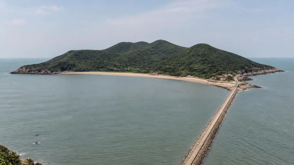
Lian Island is called East-West Lian Island because it is two islands joined, and it is the largest bedrock island in Jiangsu. It runs southeast to northwest across Haizhou Bay with 17.66 kilometres of coastline, and its high point, Damaojian, reaches 357.8 metres — high enough that from the top you are looking down on a container port.
Everything else in the Yuntai chain stopped being an island in the eighteenth and nineteenth centuries. The Yellow River, diverted south into the bed of the Huai, silted the channels between the mountains and the mainland and turned an archipelago into a headland; Mount Huaguo, which had been offshore in the Yellow Sea when Journey to the West was written, became dry land in 1711.
Lian Island held out. It was too far offshore to be filled in, and until the 1990s you could only get here by boat.
The dyke
What ended that was the West Great Dyke, 6.7 kilometres of causeway running out to Jiajiazui on West Lian Island. Construction began on 1 April 1985. It passed national completion inspection on 30 August 1994, after which water mains were laid along it, and it opened to traffic in 1996 — nine years of work to end two thousand years of separation.
It is free to drive, and driving it is the best part of the approach: open water on both sides, the port cranes of Lianyungang behind you, the island’s wooded ridge ahead. It was built to shelter the harbour rather than to serve tourists, and the scenic area is a beneficiary rather than a cause.
But it completes a sequence that runs across this whole coast. A river silted the mountains to the mainland by accident in the eighteenth century, and an engineering bureau did the same to the last island on purpose in the twentieth.
How big it is
The island’s area is reported four different ways, depending on which document you are holding.
The land area given in the geographical literature is 5.13 square kilometres. The most commonly cited scenic-area figure is 7.57 square kilometres, with about eighty per cent forest cover. The official tourism material says 8.1. The 5A application put it at 8.85.
The gap between the smallest and largest figures is not a rounding error — it is a factor of more than one and a half. The likeliest explanation sits in the wording: 5.13 is explicitly land area, which implies the larger numbers are taking in sea, tidal flat, the causeway, or the administrative area of the scenic zone rather than the island itself. Nobody says which. It is worth noticing rather than worrying about, and the pattern recurs across Chinese scenic-area literature, where the headline number tends to be whichever one was to hand when the brochure went to print.
Dashawan
The main beach is Dashawan: roughly 1,800 metres of sand averaging about 150 metres from treeline to water, on a bay facing north into the Yellow Sea. It is the largest bathing beach in Jiangsu and one of sixteen nationally on the state’s healthy-bathing-water monitoring list.
Manage your expectations about the kind of beach this is. Lianyungang is a major container port and this is its municipal seaside, which means genuinely popular, genuinely crowded in July and August, and equipped accordingly. What it is not is a quiet strand. The water is Yellow Sea water: shallow, warm in summer, and the colour of the sediment that built this entire coastline.
Suma Bay and the general’s horses
At the other end of the island is Suma Bay, quieter and rockier and better.
The name comes from a general of the late Ming, Su Ziheng, who is said to have pastured his horses on Yingyou Shan — Su’s horse bay. It now holds an ecological park: cabins under the hillside trees, a boardwalk along the cliff, a stone carved with the phrase about sea and sky being of one colour, and another carved with the vow of the sea and the mountain, which is what Chinese couples swear on instead of anything institutional. It is a wedding-photograph location, and on a spring weekend you will see the dresses.
The clifftop boardwalk between Suma Bay and Dashawan is the best walk on the island, and there is a shuttle if you would rather not do it twice. The rest of the island’s attractions are the ordinary furniture of a modern coastal park — the Jinsheng Chan Temple, the Wolong boardwalk, an ice-and-snow world of the kind that has appeared at every Chinese scenic area in the past five years, and a section called Aolai Wonderland.
That last name is worth a moment. Aolai is the country in Journey to the West, the one beyond the sea near the mountain where the Monkey King was born. The mountain claiming to be that mountain is across the bay. The name has now walked over the water to the island, which is a compact demonstration of how a literary claim spreads once a city commits to it: first one peak, then the range, then a beach twenty kilometres away.
Kelp, then oysters
Lian Island’s other life is a fishing village, and it is still there behind the car parks.
The water is the reason. Haizhou Bay is one of China’s eight great fishing grounds — 7,900 square nautical miles of southern Yellow Sea, sixteen to fifty metres deep, with a mouth forty-two kilometres wide and more than two hundred commercially fished species: yellow croaker, hairtail, swimming crab, prawn. Or it was. The seasonal runs have effectively gone, taken by overfishing, and the municipal response has been to build marine ranches instead; Lianyungang was granted one of the country’s first national demonstration marine ranches in 2015.
The village economy has been rebuilt from scratch about four times in seventy years. Fishermen worked in cooperatives after 1949. In October 1958 the Xishan brigade began learning to farm kelp, and through the 1970s and early 1980s kelp was the island’s business — teams growing it, cutting it and drying it collectively, most of the processed crop bought up by the municipal fisheries company. That was the first time anything from this island had a name attached to it. In the 1980s production went back to individual households, kelp farming shrank and the boat count rose; in the 1990s the wooden boats were replaced with steel trawlers and the fleet started working far offshore. Then aquaculture again: 23,000 mu of laver and nearly 8,000 of mussels by 2011, on a fishery output of 210 million yuan and an average fisherman’s net income of 12,000 yuan. The current crop is oysters, farmed across a claimed 80,000 mu of what the local government calls sea farmland.
The resident population is about 5,400 people, in four communities — Daluqiao, West Lian Island, Shawan and East Lian Island. The village history museum on the western side holds more than fifty paintings by an old fisherman, Yang Yaoyue, reconstructing how the work used to be done, a handwritten collection of Legends of Lian Island by a municipal intangible-heritage bearer, and model boats built by a man who used to build the real ones. A fishermen’s culture festival has run during the summer fishing moratorium for eleven consecutive years.
This is the part of the island that the 5A rating is not really about, and it is the part most worth an hour.
Becoming a 5A
Lian Island reached 5A in early 2024, as the seventh entry on a Ministry of Culture and Tourism list of twenty-one new top-grade scenic areas. It was Lianyungang’s second, after Mount Huaguo took the city’s first in 2016.
The process took eight years: campaign from 2016, landscape-quality review passed in 2019, and then the pandemic. One consequence is that a fair amount of what you will read is out of date — government pages and travel sites still describe Lian Island as a 4A area, or by its other designation as a national marine special protected area, and both were correct until recently.
The upgrade is not purely cosmetic. A 5A rating carries requirements for signage, toilets, transport and interpretation, and it is the difference between a beach with a car park and a managed site where the Han carvings have a path and a board. Whether the board is any good is a separate question. What the rating reliably delivers is that the thing exists and is findable, which for a two-thousand-year-old boundary marker at the top of a public beach is not nothing.
Visiting
Tickets are 50 yuan in peak season and 30 off-peak; the site is open 08:30 to 17:30 with last entry at 17:00. City buses You 3 and You 6 run out from Lianyungang, and a shuttle links Dashawan with Suma Bay inside the site. Swimming is a summer proposition; the walking is better in spring and autumn.
Do the carving. It takes ten minutes and almost nobody bothers, and it is the most unusual object on this coast by a wide margin — more unusual than the mountain across the bay that everybody comes for.
Two things to hold together while you are looking at it. The men who cut it were marking the line between two counties of an empire that was, at that precise moment, not being ruled by the dynasty it belonged to. Wang Mang’s Xin lasted fourteen years, and when the Han came back it struck his name off everything it could reach — which is part of why so little from his reign survives, and why a functional boundary note on a cliff above the tideline outlasted the archives.
And they were standing on an island. It stayed one for another one thousand nine hundred and eighty-four years.
The LoreLens app can read you the Han inscription’s text at the rock face — including which four characters are disputed, and what changes depending on how you read them.
Location profile
Where it is

Frequently asked questions
What exactly are the boundary carvings?
Two rock inscriptions from the Xin dynasty of Wang Mang, cut in AD 12, dividing the Han commanderies of Donghai and Langya — specifically Qu county of Donghai from Gui county of Langya. One is at Suma Bay at the southern edge of the beach, with sixty characters in twelve lines still legible; the other, weathered and broken in two, is on the seaward side of Lighthouse Hill. They are the only relatively complete, unambiguously dated Han boundary carvings known in China, and because the text allocates sea as well as land, they are also the earliest surviving Chinese statement of maritime jurisdiction.
Can you drive to Lian Island?
Yes. The West Great Dyke, 6.7 kilometres of causeway, was begun in April 1985, passed its national completion inspection in August 1994 and opened to traffic in 1996. It is free to drive. Before that the island could only be reached by boat, which makes it the last of the Yuntai islands to lose its isolation — the others were silted to the mainland by the Yellow River in the eighteenth and nineteenth centuries.
Is the beach any good?
Dashawan is the largest bathing beach in Jiangsu — roughly 1,800 metres of sand, averaging about 150 metres deep — and one of sixteen beaches on the national water-quality monitoring list. It is a working public beach in a port city, not a resort strand, and it is busy in July and August. Suma Bay, at the other end of the island, is quieter and rockier.
When did Lian Island become a 5A scenic area?
In early 2024, as the seventh entry on the Ministry of Culture and Tourism's list of twenty-one new 5A areas. It was Lianyungang's second, after Mount Huaguo in 2016. The campaign began in 2016 and the landscape-quality review was passed in 2019, so a good deal of material online still describes it as 4A.
How much time do you need?
A day. Dashawan and Suma Bay are at opposite ends with a clifftop boardwalk and a shuttle between them; the Suma Bay carving is a few minutes' walk from the sand. Tickets are 50 yuan in peak season and 30 off-peak, with the gates open 08:30 to 17:30 and last entry at 17:00.