Shanghai
Xisha and Mingzhu Lake: Ground That Is Not Finished
Shanghai's newest 5A scenic area sits on an island that first broke the surface in the Tang dynasty, drowned its own county seat five times, and has doubled in size since 1950. The name on the gate belongs to a shoal that sank six hundred years ago.
5A View location, maps and nearby scenic areasShanghai’s five national 5A scenic areas are, on the whole, about things people built: a television tower, a science museum, a set of Party congress memorials, a safari park. The fifth is different. At the western end of Chongming Island, the Xisha Mingzhu Lake Scenic Area is about the ground, and the interesting thing about the ground is that it is not finished.
Chongming is a deposit. The Yangtze carries silt to its mouth, the silt settles where the current slows, and an island accumulates. The process has a documented start date, it drowned a county seat repeatedly, and it is still going on.
Two shoals in the Tang, and neither of them is here
The record begins in the Wude era of the Tang, 618 to 626. Two shoals broke the surface in the water south of a larger island called Dongbuzhou, in the area of what is now Lüsi on the Qidong peninsula. They were named Dongsha and Xisha—east shoal and west shoal—and English-language accounts describe them as initially some 70 kilometres apart. Xisha also carried a second name, Gujunsha.
In 705, the first year of the Shenlong era, a town was established on Xisha. It was called Chongming: chong for high, ming for open and clear, together meaning flat clean ground standing above the water. That is where the island’s name comes from, and it is worth noticing that the name describes a surface, not a place.
Counted from 618, the island’s land is a little over fourteen centuries old. Chinese reference texts still routinely write “more than 1,300 years,” a phrasing that has been copied forward for decades without being recalculated; both are describing the same start date.
Then the arithmetic turns over. Early in the Ming, a major subsidence sank the whole of Dongsha and most of Xisha, and the population largely emigrated back to the mainland. Over the following centuries Xisha is recorded as sinking again along with Chen’ensha, Fanliansha and others. The two shoals that gave Shanghai’s northernmost district its name are not part of the island you can visit.
A county seat that had to be moved five times
The clearest measure of how unstable this ground was is administrative. Chongming’s seat of government kept falling into the river.
A prefecture was organised here in 1277 under the Yuan, with a walled seat on the shoal called Yaoliusha. In 1352 the south side of that wall was undercut by tides and collapsed; a new wall went up about fifteen li north. In 1420 the south side went again, and the seat moved roughly ten li north. In 1529 the walls fell to the sea and the magistrate built an earth wall on Sansha, some fifty li away across water. Between 1550 and 1553 the northeast corner eroded and a decision was taken to build again, on Pingyangsha.
That last move ran into something other than water. On 7 May 1554, with the new walls still going up, pirates attacked through the breached northeast section and got inside. The magistrate, Tang Yicen, led soldiers and townspeople in street fighting, drove them out, and died of his wounds; two days later the raiders took the county office again before being pushed out a second time. A brick wall was finally funded in 1555 with 40,000 taels from the imperial treasury and took ten months.
It did not settle the question either. In 1583 the northwest corner collapsed and the seat moved once more, to the shoal called Changsha, where construction ran from 1586 to 1588. That site is the ancestor of today’s Chengqiao. Meanwhile the shoals themselves were merging: by around 1644 a single mass ran west to Gaotousha, and unification with the remaining nearby shoals by 1681 produced something recognisable as present-day Chongming.
Five relocations of a walled city in three centuries is not bad planning. It is what happens when a government tries to hold a fixed point on a moving deposit.
What the name on the gate does and does not inherit
Which brings up the name of the scenic area. The Xisha here is in Lühua town, at the far western end of the present island. The Tang Xisha lay off what is now the Qidong peninsula, on the north side of the estuary, and it sank.
No source I could open connects the two. The honest reading is that the word was reused rather than inherited, because sha—shoal—is simply the basic vocabulary of this place. Chongming’s historical toponymy is a long list of them: Yaoliusha, Sansha, Pingyangsha, Yuanjiasha, Gaotousha, Yonglongsha, dozens more. A new bank of silt at the west end gets called the west shoal for the same reason the Tang one did. The echo is real; the continuity is not.
The scenic area’s own name has moved too. For years the pair was rated 4A under the name Mingzhu Lake and Xisha Wetland Scenic Area. On 6 February 2024 the Ministry of Culture and Tourism published a list of twenty-one newly confirmed 5A scenic areas, and item six reads, in translation, Xisha Mingzhu Lake Scenic Area, Chongming District, Shanghai. Worth citing precisely, because the older 4A name is still on signage and in guidebooks.
Two parks, one rating
What you actually visit is two places with two characters.
Mingzhu Lake Park was established in 2005 around the largest freshwater lake on the island. Reference works give the park as about 6,500 mu, with a water area of more than 3,000 mu and a ring of roughly 4,500 mu of catchment woodland; inside there is a small hall of fish specimens covering more than thirty species from the lake and the Yangtze mouth. One published account describes it as free to enter, which is exactly the kind of detail that changes with a rating upgrade—check rather than assume.
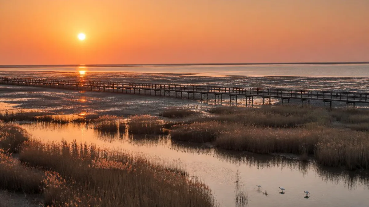
Xisha Wetland, formally Xisha National Wetland Park, is next to the river in Lühua town, opened to the public on 1 October 2006, and is given as about 300 hectares. Its defining structure is a boardwalk quoted at 6,800 metres that runs out over tidal flat, and it holds the monument marking the Chongming Island National Geopark, whose designated area covers the whole island.
One thing I could not establish: how the lake basin exists at all. Chongming has no natural relief—average elevation is quoted between about 3.2 and 4.2 metres, and the island’s highest point is an artificial mound, Jin’ao Hill, at 12 metres. Where there are no hills there are no valleys to dam. The sources I could open call Mingzhu Lake the island’s largest freshwater lake and stop there; treat the gap as open rather than fill it with a guess.
The tide is the exhibit
Xisha’s boardwalk is not a viewing platform with a walkway attached. It is the whole point.
The Yangtze mouth is tidal, and a mudflat inside a tidal range is submerged and exposed twice a day. That cycle is what makes the flat productive: each tide delivers material, each ebb leaves a surface that burrowing and surface-feeding animals can work. Crabs and mudskippers are the two the walkway is built for—mudskippers being fish that hold territory on exposed mud and breathe partly through wet skin, which only makes sense where land and water alternate.
Local publicity often calls this the only wetland in the Yangtze estuary with a natural tidal regime. I could not open a source that supports the exclusivity, so read it as a promotional claim and keep the part that is plainly true: this is a place where you can walk out over the interface and watch it change within one visit.
The frontage faces the river to the west, which is why late afternoon is the time everyone recommends. Sunset over open water is the wetland’s most-photographed asset, and unlike a rating or a ticket price it is not going to be revised.
The structure itself is a liability, and its history says so. In August 2018 the tropical storm known as Yagi damaged the timber walkways and other installations badly enough to force the park to close for reconstruction; it stayed shut for roughly two and a half years and reopened on 26 February 2021, less than three years before the joint 5A confirmation. Take that as the operating condition rather than an anecdote. Timber standing in brackish water on an exposed estuarine shore, in a region that gets typhoons, needs periodic rebuilding. Anything here about what is walkable is a snapshot; the gate is the authority.
Land that is still being added, and who is adding it
Now the part that makes this island unlike anywhere else in Shanghai: the surface area keeps changing, and you can read who is responsible.
The natural side is real but poorly quantified. One figure repeated in Chinese reference works has the island extending eastward at about 143 metres a year and gaining roughly 487 hectares annually. No measurement window is attached to it anywhere I could check, so treat it as an order of magnitude rather than a rate.
The engineered side is better anchored. Large-scale reclamation of the northern and eastern tidal flats, concentrated in the 1960s and 1990s, is described as having doubled the island’s area between 1950 and 2010. Reclamation also produced an administrative oddity: the separate island of Yonglongsha, which last appeared in the north channel in 1937 and was stabilised and expanded by workers from Nantong, was absorbed into Chongming’s north shore—Qidong’s Qilong joined in 1972, Haimen’s Haiyong separately in 1975. Both remain part of Jiangsu. The result is one island administered by two provincial-level jurisdictions and three county-level units, with the boundary running across farmland rather than water.
The area figures behave exactly as you would expect. The island alone is given as about 1,041 square kilometres in one official description, around 1,200 to 1,225 in others, and 1,267 as of 2010 in an English-language account; the district including Changxing and Hengsha is put at about 1,411. These are not competing errors. They are different dates and different boundaries on an object whose edges move.
The reserve that is not here
The most consequential thing to get straight before you go is what this scenic area is not.
Chongming Dongtan National Nature Reserve occupies the eastern tip of the island, at the far end of a landmass roughly eighty kilometres long. It is a national nature reserve, not a wetland park, and in July 2024 it was inscribed as part of the second phase of the Migratory Bird Sanctuaries along the Coast of the Yellow Sea and Bohai Gulf of China—Shanghai’s first natural World Heritage property. If you have read that Chongming holds a World Heritage bird site, that is the site, and it is not the one with the 6,800-metre boardwalk.
The shared background is the East Asian–Australasian Flyway, running from the Taimyr Peninsula and Alaska to Australia and New Zealand, and described as supporting over 50 million migratory waterbirds from more than 250 populations, including 32 globally threatened species; its partnership has identified about 1,060 internationally important sites. Estuary mudflats matter on that route because shorebirds cannot carry fuel for the whole journey, and the productivity of a tidal flat is what refuelling means.
Dongtan also carries a cautionary story. In January 2008 a memorandum was signed to develop it as a model sustainable eco-city, with a state investment group, Tongji University, Arup, HSBC and a sustainable-development firm as signatories. It did not happen; accounts place the collapse after the removal of Shanghai’s Party secretary in 2006 and report the project as failed. The reserve remains; the city was never built.
Getting there is the hard part
For a site inside the Shanghai municipality, access is the single most useful thing to plan.
For more than a thousand years the island had no land link. That ended at 18:00 on 31 October 2009, when the Shanghai Yangtze Bridge and Tunnel opened: a double-deck tunnel of about 8.95 kilometres from Pudong to Changxing Island, then a bridge of about 16.63 kilometres across the northeast channel to Chenjia. Both are part of the G40 expressway. A toll around 50 yuan each way has been quoted for cars under seven seats, and design capacity of 3,200 vehicles an hour across three lanes per direction explains the rest: holiday congestion is chronic, and from 21 January 2024 flow towards the city has been metered by lane signals during peak periods.
Public transport exists but is not fast. Long-distance coach lines run between the bridgehead and city terminals, two of them terminating at the metro station outside the Shanghai Science and Technology Museum. Eighteen ferry routes still operate, including Chengqiao’s Nanmen Port to Baoshan and to southern Jiangsu. Within the island there are dozens of bus lines but long headways, and the scenic area is at the west end while the bridge lands at the southeast corner.
Metro Line 22, formerly the Chongming line, is the change everyone is waiting for and it is not open yet. Reported specifications are 43.02 kilometres entirely in tunnel, eight stations with one on Changxing and three on Chongming, six-car suburban stock at up to 120 km/h, and investment of about 32.82 billion yuan. Tunnelling was reported complete on 26 October 2025 and track laying on 21 April 2026. A suburban-line fare rule adopted in November 2024 prices it per passenger-kilometre with a minimum fare rather than on the standard metro scale. Until it opens, budget two hours each way and check the last coach.
A flat island making a plan for itself
Chongming has been designated for ecological rather than industrial development since the mid-2000s; senior leadership inspections in 2004 and 2007 endorsed building it as a modern ecological island, and the county became a district of Shanghai in 2016. The visible results are planted green infrastructure and events. Dongping National Forest Park in the island’s centre began as reclamation in November 1959, opened to the public in 1989, became a national forest park in 1993, and covers about 3.55 square kilometres of planted trees—described as the largest artificial plain forest in eastern China. The tenth China Flower Expo was held in that area from 21 May to 2 July 2021.
Set against that, the ordinary economy is agricultural and aquatic. Chongming’s hairy crabs are the island’s own product, and it supplies the crab seed used at Yangcheng Lake—which explains why autumn here is a food season more than a scenery season.
Stand on the boardwalk and look down
Before leaving the wetland, give the flat below the planks two minutes.
What you are standing over arrived recently, in geological terms, as suspended material in a river that drains most of China. It settled here because the current slowed. It will keep arriving, and some of it will be moved deliberately: an island that doubled in size between 1950 and 2010 did so mostly because people built embankments and let the silt fill in behind them.
Everything else here follows from that. A county seat rebuilt five times, a highest point piled up by hand to reach twelve metres, a national geopark whose subject is not rock but sediment, and a name on the gate that belonged to a shoal which no longer exists. The tide will be back in six hours, carrying more of it.
The LoreLens app can help you identify estuarine wetland plants, mudflat animals and coastal landforms while explaining the geology that made the ground you are standing on.
Location profile
Where it is

Frequently asked questions
Is Xisha Wetland the same place as Mingzhu Lake?
No. They are two adjacent but separate parks at the western end of Chongming Island that were assessed together as one scenic area. Mingzhu Lake Park was established in 2005 around the largest freshwater lake on the island; reference works give the park as about 6,500 mu with more than 3,000 mu of water and a ring of roughly 4,500 mu of catchment woodland, plus a small hall of fish specimens covering more than thirty species from the lake and the Yangtze mouth. Xisha Wetland, formally Xisha National Wetland Park, is in Lühua town, opened on 1 October 2006, is given as about 300 hectares, and is built around a boardwalk quoted at 6,800 metres that runs out over tidal mudflat. The pair carried a combined 4A rating for years under the name Mingzhu Lake and Xisha Wetland, and were confirmed as the 5A-rated Xisha Mingzhu Lake Scenic Area by the Ministry of Culture and Tourism on 6 February 2024. Opening hours, gates and any combined ticket are set locally and change, so confirm on the day.
Is this where the famous Chongming bird reserve is?
No, and this is the single most common mix-up on the island. Chongming Dongtan National Nature Reserve is at the eastern tip, at the opposite end of an island roughly eighty kilometres long, and it is a separate institution with separate access rules. It is also the one with the international status: in July 2024 it was inscribed as part of the second phase of the Migratory Bird Sanctuaries along the Coast of the Yellow Sea and Bohai Gulf of China, making it Shanghai's first natural World Heritage property. Xisha Wetland is a wetland park with a public boardwalk, not a national nature reserve. Both sit on the same flyway, and birds do not respect the distinction, but the paperwork, the management and the visiting arrangements are unrelated.
How long does it take to get there from central Shanghai, and can I use the metro?
Allow two hours each way as a working assumption, and more on holiday weekends. The island had no land connection at all until the Shanghai Yangtze Bridge and Tunnel opened at 18:00 on 31 October 2009, and that route is a single corridor: a tunnel of about 8.95 kilometres to Changxing Island, then a bridge of about 16.63 kilometres to Chenjia at Chongming's southeast corner. Design capacity is quoted at 3,200 vehicles an hour with three lanes each way, which is why holiday queues are routine and why lane-signal metering was introduced towards the city in January 2024. Long-distance coach lines run from the bridgehead to city terminals, two of them to the metro station outside the Shanghai Science and Technology Museum. Metro Line 22, the former Chongming line, is under construction rather than open: its tunnels were reported holed through on 26 October 2025 and its track completed on 21 April 2026, with eight stations of which three are on Chongming. Buses within the island are sparse, so plan the last leg deliberately.
What is actually worth doing there, and when?
Treat it as two different visits. The wetland is about the tide and the light: the boardwalk exists so that you can stand over mudflat that is submerged and exposed twice a day, and the animals that live on that flat—crabs and mudskippers among them—are what the flat is for. West-facing river frontage makes late afternoon the obvious time. Mingzhu Lake is the calmer half, a lake ringed by planted woodland, with boating and organised fishing among the operator-run activities rather than natural features. Autumn is the island's own season for a non-scenic reason: Chongming is a hairy-crab place, and supplies crab seed to Yangcheng Lake. Ferry sailings, boat hire, cycle rental and seasonal closures are all set locally, so confirm at the gate rather than from any list, including this one.
Sources and further reading
Background references for the history and place names in this guide. Opening hours, ticketing and access change often — always confirm with official local information before travelling.