Gansu · Tianshui
Maijishan: The Cliff That Refused the Chisel
A mountain of weakly cemented conglomerate that could not hold a carved line, the clay-over-armature workaround its sculptors invented instead, and the reason China's fourth great cave complex looks nothing like the other three.
5A View location, maps and nearby scenic areasThere is a rule of thumb about Chinese cave temples that works almost everywhere and fails completely here. Yungang carves sandstone. Longmen carves limestone. Dunhuang, whose rock is too poor for either, paints. Maijishan does none of those things: it models in clay, on a scale nobody else attempted, and it does so for a reason you can see in the first two metres of the approach path.
The reason is the mountain.
A haystack of the wrong rock
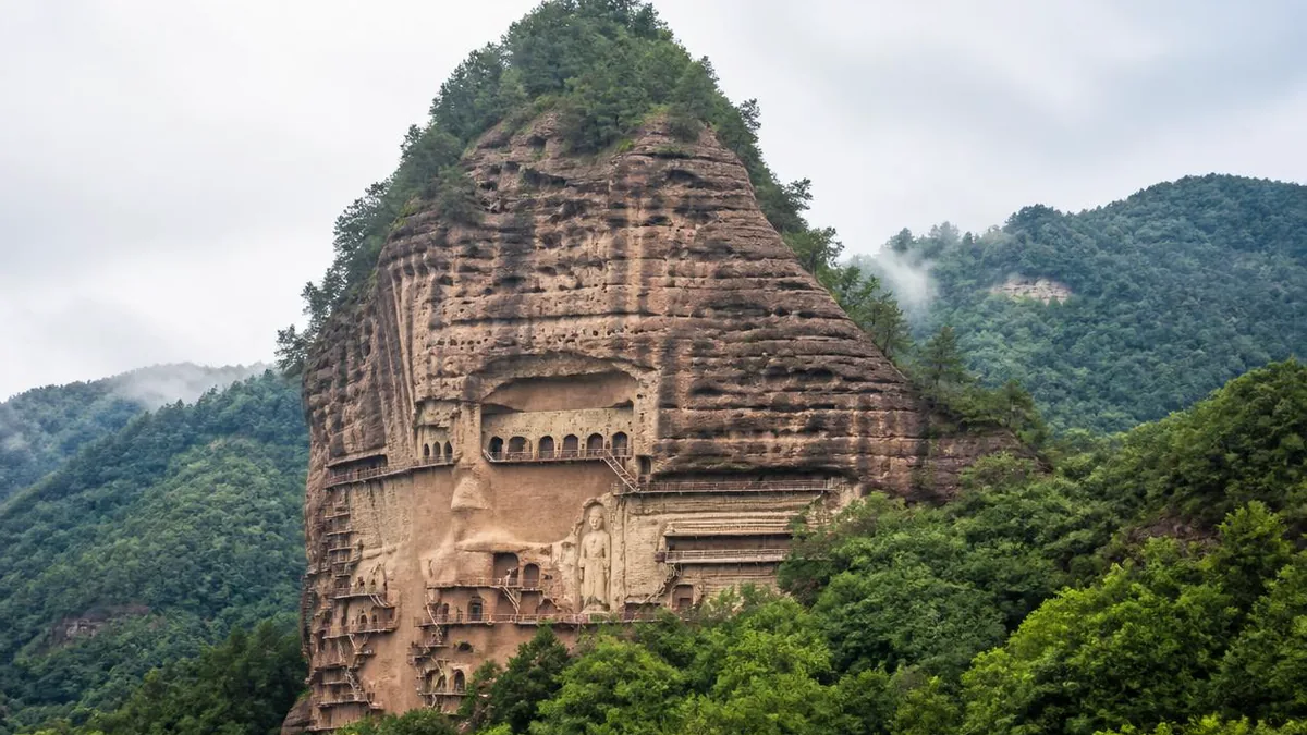
Maijishan stands roughly forty-five kilometres southeast of central Tianshui, in a fold of the Xiaolong Mountains that is green in a way most of Gansu is not. The name is agricultural and exact: maiji is a stack of harvested wheat, and the peak really does look like one, a rounded cone with a sheer bitten-out face on its southwest side.
The numbers for the cliff are worth separating, because they get mixed up constantly. The mountain rises about 142 metres from its base. The worked face is roughly 200 metres wide. Caves are cut between about ten and eighty metres above the ground, with most of them concentrated in the twenty-to-sixty-metre band. Measured cliff by cliff, the East Cliff face is given as about 53 metres long with caves distributed from ground level up to 37 metres; the West Cliff as about 63 metres long with caves from 10 to 47 metres.
The other thing the setting gives you is damp. Surrounded by forested hills, this is a humid pocket, and its most famous local sight is not a statue at all: Maiji misty rain, the first of the eight classical views of Qinzhou, when cloud sits in the valley and the peak comes and goes inside it.
Now the geology, because everything else follows from it. The cliff is a weakly cemented sandy conglomerate, generally assigned to the Tertiary. Older Chinese descriptions call it a purple-brown water-laid mother-and-child rock, which is a good field name for what it is: rounded pebbles held in a sandy, poorly bonded matrix.
Two properties matter. First, it is easy to excavate. You can hollow a chamber out of it quickly, and the mountain already had natural cavities to start from. Second, and fatally for carving, it will not take detail. Cut into it with any precision and the pebbles pull free while the matrix around them crumbles. There is no way to leave a crisp drapery fold, a fingernail or an eyelid in a rock whose grains are the size of a thumbnail and barely glued together.
That weakness has never stopped being a problem. The same friability is why the cliff has shed material in earthquakes, and why the whole face was consolidated with modern engineering in the twentieth century. What the ancient sculptors did was not to fight the rock. They agreed with it.
What they built instead
The workaround is a family of techniques, chosen by scale.
For the largest figures: a stone-core clay sculpture. Masons roughed the whole body out of the living cliff as a crude blank, then built the finished surface on top of it in clay. The blank carries the weight and the clay carries the art. The East Cliff Buddha, Cave 13, is the demonstration piece, a Sui-dynasty triad of Amitabha with Avalokitesvara and Mahasthamaprapta set in a shallow open niche; its height is variously given as 15.7, 15.8, 16 or 17 metres depending on where the measurement starts.
For medium and small figures: a wooden armature of posts and rods, bulked out with reed, hemp fibre and straw, then clayed. Reducing dead weight was not an aesthetic choice on a cliff of crumbling conglomerate; it was structural.
For crowds and backgrounds: moulded relief and appliqué figures, pressed from moulds and fixed to the wall, which is how the thousand-Buddha walls get populated without a thousand separate sculptures.
The material recipe is local to the point of banality: sand, clay, hemp, wheat straw. The construction detail is not. In one cave, the Buddha base was built with coarse clay and two deliberate gravel courses worked between the clay layers, which set into a firm bond, and wooden rods were stood in the two front corners and wrapped inside the clay to hold the layers in place. That is a sculptor thinking like a builder.
Why this is not Yungang, and not Dunhuang either
Set the four great complexes side by side and the technical logic sorts them. Yungang and Longmen had competent rock, so they carved, and their fame is stone. Dunhuang’s conglomerate is even worse than Maijishan’s, so it went to painting, with painted clay figures as a supporting cast. Maijishan had bad rock and chose sculpture anyway, going all in on clay at architectural scale.
That is the substance behind the nickname. The sculptor Liu Kaiqu called the place a great sculpture museum of successive dynasties, and the phrase hardened into the oriental sculpture gallery. It is usually quoted as praise for the artistry when it is really a description of a technical corner: an unbroken sequence of clay modelling from the Sixteen Kingdoms period through the Northern Wei, Western Wei, Northern Zhou, Sui, Tang, Song, Yuan, Ming and Qing, in one place, because the local answer to hard sculpture was always the same answer.
It also travelled. The same basic process appears at Dunhuang and at other Gansu sites including Jintasi, Tiantishan, Bingling Temple and Shuiliandong, which suggests a regional workshop tradition rather than one mountain’s private trick.
The earthquake, and what the record actually supports
The most repeated sentence about Maijishan is that an earthquake in 734 split the cliff in two. Handle it in layers.
What holds. A major earthquake struck Qinzhou in the twenty-second year of the Kaiyuan era, 734. The histories describe a rumbling sound, hills turned into valleys, official buildings and dwellings destroyed, ground opening and closing again. Death tolls in the sources run from just over a hundred to over four thousand. The prefecture seat was temporarily moved. Modern seismological work puts the magnitude near 7, epicentral intensity at X, the distance to the grottoes at about 45.8 kilometres, the resulting intensity at the site at IX to X, and the seismogenic structure as the Wushan-Tianshui segment of the fault zone along the northern margin of the West Qinling.
What is disputed. That this particular earthquake is what removed the middle of the cliff. A 2007 paper in Seismology and Geology noted that the claim, repeated since at least the 1980s, has no direct support in the historical record, and used a shallow-cut mason’s inscription beside the west pillar of Cave 4 to bracket the collapse of the cliff face below that cave to somewhere between 619 and 1269. Some accounts add a destructive earthquake in 582, others in 600.
What is simply visible. The middle is gone. What survives is two groups separated by a blank face, and blocks from the fall still lying at the foot of the mountain. One consequence is chronological: the middle of the cliff is where the Sui and Tang caves were concentrated, which is why those dynasties are comparatively thin here while the Northern Dynasties are so strong.
Counting caves is harder than it looks
You will meet at least three totals. They are not contradictions so much as different questions.
- 221 niches and caves, 3,938 works, 10,632 figures, 979.54 square metres of wall painting. This is the current official and World Heritage figure, and it counts caves and niches together.
- 194 caves, over 7,800 sculptures, over 1,000 square metres of painting. The long-standing older count, still in circulation in tourism material.
- 198 caves, numbered 1 to 196 plus 217 and 218; 57 on the East Cliff, 141 on the West Cliff; 12,182 figures. A count that separates moulded relief and appliqué out and adds them in, which is why the figure total jumps.
Earlier surveys ran lower still, around 190 caves and 7,200 sculptures, because the numbering was built up over decades. Feng Guorui could only reach and number 121 caves in 1941, the walkways being gone; a 1952 survey got to 157; the sequence was not extended to 221 until 2008. Three rules of thumb: check whether niches are counted with caves, whether works or figures are being counted, and whether appliqué is in or out.
What is actually up there
The West Cliff holds most of the early material and most of the best. Cave 133, the Ten Thousand Buddhas cave, is the largest chamber on the mountain and holds the small standing monk whose downcast, half-amused expression is marketed nationally as the oriental smile. Cave 121 has the much-photographed pair of a bodhisattva and a disciple leaning shoulder to shoulder, heads inclined together as though whispering. Cave 43 is the earliest of the cliff-pavilion structures and is identified as the tomb cave of the Western Wei empress Yifu; Cave 44, less than ten metres west of it, holds a Buddha whose main figure stands 1.60 metres and which is routinely called the high point of Western Wei clay sculpture, sometimes said to be modelled on the empress’s own likeness.
The East Cliff is the theatrical side: the great open galleries of the Seven Buddhas, the thousand-Buddha corridor, and Cave 13’s cliff Buddha, repaired in 1157 by a lay donor from Gangu whose name is recorded. The West Cliff Buddha, Cave 98, carries a modern intervention that is visible if you look: in 1978 it was consolidated with shotcrete and anchors following the outline of the figures.
Two details tell you how the site was read historically. Du Fu, sheltering at Qinzhou in the late 750s, climbed up and wrote a poem that opens on a wild temple with few monks left and a thin path climbing the mountain garden. The tenth-century Qinzhou writer Wang Renyu described the place as carving stone into Buddhas, ten thousand niches and a thousand chambers, and said that although it was human work one might suspect a ghost’s hand.
The walkways are part of the monument
Nobody reaches any of this without the zhandao, the plank galleries pinned to the cliff. Traditionally they ran up to twelve tiers, and the local name for the site was the twelve-tier scaffold.
They also failed. Once the medieval walkways collapsed, the West Cliff in particular went largely unvisited and unaltered from roughly the twelfth century, which is precisely why its early sculpture is so intact; the more climbable East Cliff was reworked repeatedly from the Ming onward and lost more of its original state. Inaccessibility was the best conservator this mountain ever had.
Getting back up was a twentieth-century project with named participants. Feng Guorui, a Tianshui scholar, made the first field survey in 1941, copied inscriptions, found wall paintings, numbered caves and published a lithographed gazetteer in an edition of three hundred. In 1947 he returned with a local carpenter, Wen Dequan, who led villagers in rigging planks and ropes; that is how Cave 133 was reached. A northwest survey team under Chang Shuhong of the Dunhuang research institute came in October 1952, and in July 1953 the Ministry of Culture sent a thirty-two-day expedition headed by the artist Wu Zuoren. Wu’s report singled out Wen Dequan’s sixteen-man carpenter group, who climbed forty and fifty metres of cliff on a single rope and a single plank, using surviving beam stubs and empty beam holes as their route.
What you walk on now is a later generation again: timber galleries funded in the 1950s, an east-west connection built in the 1960s, and reinforced concrete walkways installed alongside the cliff consolidation works of roughly 1976 to 1984. Something was traded for that. The consolidation covered most of the historic beam holes on the face, a real loss for the study of how the original galleries were built. Around 1,200 metres is the figure usually given for the modern total; you will also see 1,300 metres, easy to confuse with the older mural-area figure of over 1,300 square metres, so treat it with caution.
One point on a corridor
In June 2014, Maijishan entered the World Heritage List as the Maijishan Cave-Temple Complex, one component of Silk Roads: the Routes Network of Chang’an-Tianshan Corridor. That property is transnational and serial: 33 sites across China, Kazakhstan and Kyrgyzstan, of which 22 are in China and five in Gansu, the others being Yumen Pass, the Xuanquan posthouse, the Bingling Temple grottoes and the ruins of Suoyang City.
This is worth stating carefully because signage and travel copy often compress it into “Maijishan became a World Heritage Site,” which changes the meaning. What was inscribed is a corridor and the network of places that made it work; Maijishan’s value in that frame is as evidence of Buddhism moving east and of a distinctly local craft response to it. Its separate and older honour is the 1961 listing in China’s first batch of nationally protected key cultural relic sites.
Walking it, and what to expect
Plan for the cliff more than for the caves. The walkways are narrow, open on one side and high, and the site’s own guidance is candid that people with a fear of heights find the upper tiers genuinely hard. There is no way to see the major caves without going up. Wear shoes with grip, keep both hands free, and expect one-way sections where you cannot easily turn back against the flow.
Photography inside the caves is generally not allowed, and most of the finest interiors are behind grilles; the deep ones are shown only through the special-cave arrangement, separately booked and separately priced. Which caves are on that list, how the walkways are routed, whether the shuttle from the outer gate is running and what any of it costs are all matters for the day you arrive. Confirm at the gate, not from an article.
Two hours is a realistic minimum on the cliff and half a day is better; the wider Maijishan scenic area extends beyond this peak to other sections in the same hills. Wet weather is not a reason to cancel. Low cloud on this mountain is closer to the classical view of it than a blue sky is.
The argument the mountain settled
Stand at the foot and look at the face before you climb. You are looking at a rock that could not do what the great carving sites did, in a place that decided to make monumental sculpture anyway. Every technique on this cliff, from the stone blanks under the giant Buddhas to the straw in the clay to the moulded figures on the thousand-Buddha walls, is a workaround for a mountain made of pebbles that will not stay put. The earthquake that took the middle of the cliff is the same weakness read at a different scale, and so is the concrete that now holds the face together.
The usual line is that Maijishan is remarkable despite its rock. It is the other way round. The rock chose the medium, the medium ran unbroken for well over a thousand years, and the result is the one place in China where you can watch clay do the job that stone does everywhere else.
The LoreLens app can help you identify cave-temple architecture, sculpture techniques and cliff geology while explaining the history behind them.
Location profile
Where it is

Frequently asked questions
Why are the figures at Maijishan modelled in clay instead of carved from stone?
Because the mountain will not take a carved line. Maijishan is built of weakly cemented sandy conglomerate, usually assigned to the Tertiary and described in older Chinese sources as a purple-brown water-laid rock of pebbles set in a sand matrix. It is easy to hollow out and impossible to finish: the moment a chisel tries to cut a fold of drapery or an eyelid, the pebbles pluck out and the matrix crumbles. So the sculptors excavated the chamber in stone and built the figure in clay over an armature. Big figures got a rough stone core cut from the cliff itself; smaller ones got wooden posts, reeds and hemp. The clay was mixed with sand, chopped straw and fibre, laid coarse first and fine last. Both the clay and the technique are documented in the caves themselves, including a Buddha base with gravel layers deliberately worked between the clay courses and wooden rods set into the front corners to hold the mass together.
Did an earthquake really split the cliff into an East Cliff and a West Cliff?
That is the standard account, and it is contested in the technical literature rather than in the guidebooks. The mainstream version attributes the collapse of the middle of the cliff to the Qinzhou earthquake of 734, in the twenty-second year of the Kaiyuan era, estimated near magnitude 7, with an epicentral intensity of X and an intensity of IX to X at the grottoes. A 2007 paper in the journal Seismology and Geology pointed out that no historical source actually records this specific damage to the caves, and used a shallow-cut mason's inscription by the west pillar of Cave 4 to argue only that a large part of the cliff face below that cave had fallen at some point between 619 and 1269. Other accounts add earthquakes in 582 or 600 to the ledger. What is not in dispute: the middle of the cliff is gone, the caves now sit in two separated groups, and boulders from the collapse still lie at the foot of the mountain.
How many caves are there, and can I see all of them?
The counts disagree because they are counting different things, so quote the basis with the number. Current official and World Heritage material gives 221 niches and caves, 3,938 works comprising 10,632 individual figures, and 979.54 square metres of wall painting. A long-standing older figure gives 194 caves and more than 7,800 sculptures. A third count lists 198 caves, numbered 1 to 196 plus 217 and 218, with 57 on the East Cliff and 141 on the West Cliff, and totals the figures at 12,182 by counting moulded relief and appliqué separately. No visitor sees all of them. The open route runs along the walkways past the large open-fronted chambers and the cliff Buddhas; several of the most important interiors are grilled shut and shown only under a separate special-cave arrangement. Which caves are open changes, so ask at the ticket office rather than planning around a list.
Is Maijishan a World Heritage Site on its own?
No, and the distinction matters. In June 2014 Maijishan was inscribed as one component of Silk Roads: the Routes Network of Chang'an-Tianshan Corridor, a transnational serial property covering 33 sites across China, Kazakhstan and Kyrgyzstan. Twenty-two of those are in China and five are in Gansu, alongside Yumen Pass, the Xuanquan posthouse, the Bingling Temple grottoes and the ruins of Suoyang City. The listed name is the Maijishan Cave-Temple Complex. Separately, it had already been in the first batch of nationally protected key cultural relic sites announced in 1961. So the honest sentence is that a Silk Road corridor was inscribed and Maijishan is one of its points, not that Maijishan was inscribed by itself.
Sources and further reading
- Maijishan Grottoes — Wikipedia
- Silk Roads: the Routes Network of Chang'an-Tianshan Corridor — Wikipedia
Background references for the history and place names in this guide. Opening hours, ticketing and access change often — always confirm with official local information before travelling.