Gansu · Linxia
Bingling Temple: The Grotto a Dam Rewrote
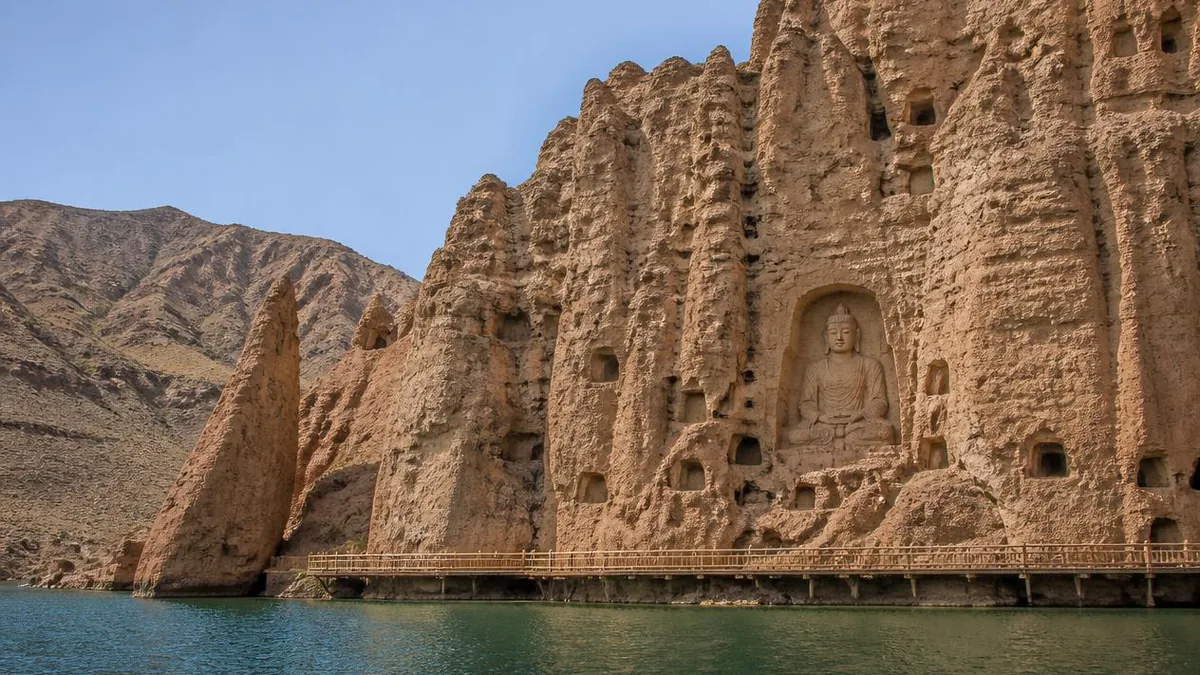
A cliff of Western Qin, Tang and Tibetan carving that stood beside a Yellow River crossing for fifteen centuries, then became a place you reach by boat, kept dry by about three metres of freeboard.
5A View location, maps and nearby scenic areasMost grottoes are described by what is carved into them. Bingling Temple is better described by how you arrive, because the arrival changed inside living memory and the carving did not.
For roughly fifteen centuries this cliff in the Xiaojishi mountains of Yongjing County, in the Linxia Hui Autonomous Prefecture, worked because it sat beside a river crossing. Then, in the late 1960s, a concrete gravity dam 147 metres high went up downstream, the Yellow River backed up into a lake of about 130 square kilometres, and the caves ended up at the tail of a reservoir. The way in became a boat.
That is the story worth carrying to the rim of the water: a fourth-century site whose accessibility was redrawn by a twentieth-century power station, and whose survival now depends on a few metres of engineered margin.
The crossing is the approach
You start at the Liujiaxia dam, commonly given as about 75 kilometres from Lanzhou, and the boat goes upstream. A speedboat crossing is repeatedly described as around fifty minutes; slower tour boats stretch the return into seven or eight hours.
Two things on the water are worth watching for. One is the junction where the Tao River enters the reservoir from the south, which is the same Tao River that drains the mountain counties of Gannan further upstream. The other is the local rhyme about red hills, pale tops and a reach where the Yellow River appears to run west, which is the kind of saying that is easier to see from a boat than to justify on a map.
Then the gorge narrows, the water turns opaque and green, and red sandstone pinnacles stand up on both banks. The site is the far end of that corridor.
Distances to the site itself are inconsistent even in careful sources: the conservation institute’s own material places the grottoes about 35 kilometres southwest of Yongjing town, while a 2015 paper in the journal Dunhuang Research by staff of the same institute puts it at about 52 kilometres. Both are presumably measuring different things. Neither is a reason to distrust the site; it is a reason to distrust any single figure attached to it.
A dam timeline, and the three metres that matter
The Liujiaxia project was begun in 1958, suspended in 1961, and resumed in 1964. Impoundment is given as October 1968 in the fullest account available, though some site histories put the filling a year earlier; the first generating unit came online in March 1969 and the station was completed in December 1974. Normal pool level is 1,735 metres, maximum storage about 5.7 billion cubic metres.
Now put the grottoes beside those numbers. The site is placed between roughly 1,738 and 2,100 metres. The protective dike built along the foot of the cliff is described as 220 metres long and 16 metres high, with a crest around 1,738.2 metres, funded by a State Council allocation of 1.5 million yuan after the problem was raised at national level.
Read that as an engineering statement rather than a heritage one. The lowest carved surfaces at Bingling Temple sit a small number of metres above the design water surface of a working reservoir, behind a wall. Four caves on the bottom tier were below the normal operating level outright and were moved before the water came.
The Buddha that was cut into nine pieces
The most drastic rescue was Cave 16. It holds a Northern Wei reclining Buddha, dated to the Yanchang period of 512 to 515 and measuring 8.6 metres, which site material describes as the earliest surviving nirvana figure preserved in a Chinese cave temple.
In April and May 1967, ahead of the water, specialists cut the figure into nine sections, crated them, and stored them in Caves 144 and 145. It stayed in boxes for more than three decades. Restoration ran from June 2001 to May 2002, and the reassembled figure is now shown in a dedicated hall rather than in its original cave.
It is worth sitting with what that means. A sculpture made to lie in a specific hollow of rock has been separated from that hollow permanently, in nine numbered pieces, for reasons that had nothing to do with Buddhism, iconoclasm or theft. The reason was a hydroelectric scheme 50-odd kilometres downstream.
The slower damage arrives as silt
Flooding is the dramatic risk. The chronic one is sediment, and it is the part almost no travel account mentions.
Bingling Temple sits at the tail of the reservoir, in the mouth of the Dasi gully. Work published in Dunhuang Research in 2015 by the conservation institute and a Gansu geotechnical firm states plainly that impoundment changed the water environment of the cave area, and that roughly a decade of drainage ditches and physically carting sand out failed to reverse the continuing rise of the gully bed. The authors’ proposed direction is not more excavation but vegetation protection, sand stabilisation and water control.
Other conservation work is better documented and more conventional. Anti-weathering treatment for the friable red sandstone was developed with the Dunhuang Academy and sprayed over about 30 square metres at inscription surfaces. Rock consolidation and seepage control ran from September 1997 to the end of 1999 on a 4.86 million yuan national allocation. Timber walkways burned in the nineteenth-century wars were replaced in stages from 1973 and again from 2002. An automatic weather station and dozens of temperature, humidity and carbon dioxide sensors went in from July 2009.
Cave 169, and a sentence that has to be exact
Cave 169 is a natural cavity, irregular, roughly 15 metres high, 26 metres wide and 9 metres deep, subdivided into some 24 numbered niches. It is the largest opening at the site and it sits high above the head of the great Tang Buddha; reaching it historically meant a rope ladder and a climb of more than forty metres.
On the side of Niche 6 is an ink inscription about 0.47 by 0.87 metres, running to more than five hundred characters. Much of it is damaged and scholars’ transcriptions differ. The last line does not: it gives a date corresponding to 24 March 420 CE, in the first year of the Jianhong era of the Western Qin ruler Qifu Chipan.
Here is the sentence that has to be exact. This is described by the site’s own researchers and by the Chinese heritage press as the earliest dated inscription so far found in any Chinese cave temple — not the earliest cave, and not the earliest Buddhist carving. The 1963 survey report made the comparison explicitly: nothing earlier was then known from the Xinjiang caves, Dunhuang, Tiantishan, Maijishan, Yungang or Longmen; Mogao’s traditional 366 founding survives only as a retrospective Tang stele with no cave securely attached; Yungang’s first five caves are dated from a text to around 460.
Two caveats travel with it. The discovery year is reported as 1962 in some accounts and 1963 in others. And the dating of specific figures inside the cave, including a donor portrait sometimes identified as the pilgrim Faxian, remains argued in the literature.
What “Bingling” might mean
The oldest recorded name is not Buddhist. Li Daoyuan’s sixth-century Commentary on the Waterways Classic records two caves in this gorge, one of them the Tangshu cave, and Tangshu is generally read as a transcription from Qiang meaning something like ghost cave or spirit cave. Under the Tang the site was called Lingyan Temple or Longxing Temple. The name Bingling, sometimes written with different characters, appears from the Song period onward.
The common explanation is Tibetan. Bingling is taken as a shortening of a Tibetan phrase built from byams pa, Maitreya, ‘bum, a hundred thousand, and gling, isle or monastery — an isle of a hundred thousand Maitreyas, which fits the site’s Maitreya colossus rather neatly. The earliest published version of this reading came from a lama interpreting for the scholar Feng Guorui during a 1951 survey.
There is a competing reading. The scholar Tsering has argued that ‘bum gling is instead a transcription of Fenglin, the Tang-period name of a pass and district here, which appears in the Old Tibetan annals from Dunhuang in connection with an iron-chain bridge; on that account the Buddhist gloss is a later folk interpretation grown over a place name that never had Tibetan meaning. A published review of the naming dispute treats it as unsettled. So should a signboard, and so should you.
Twenty-seven metres, revised by every dynasty that could reach it
Niche 171 holds the seated Maitreya that dominates the cliff: 27 metres, upper body carved from the rock and finished in clay, lower body largely modelled. It was cut in 731 CE, the nineteenth year of the Kaiyuan era, and site research attributes the funding to a Tang official responsible for the Longyou pasturelands and Liangzhou — which makes this a state-adjacent commission rather than a purely devotional one.
Everything since has edited it. A nine-storey timber pavilion once stood in front of the figure and burned in the Tongzhi-era wars of the nineteenth century. Ming restorers changed the Tang wavy hair to snail curls and added a crown, replaced the Tang double-lapel robe with a half-draped one baring the right shoulder, and rebuilt the lotus base. A three-year conservation campaign finished around 2012 or 2013 depending on the account; provincial experts signed it off, and a visible strand of the conservation profession and of visitors did not, mainly because the right hand was completed while the left was left missing.
You will also hear guides call it the ninth-largest Buddha in the world. That ranking has no stable published basis and is best left at the gate.
Three areas, and numbers that refuse to agree
The site is not one cliff. It is three: the lower temple, which is the main face inside the Dasi gully; the upper temple, a valley about 2.5 kilometres north; and Dongou, the gully between them.
The conservation institute’s own figures give 216 niches and caves in total — 195 lower, 13 upper, 8 in Dongou — with 680 stone statues, 108 clay, 27 clay-over-stone-core, about 1,000 square metres of wall painting and 56 pagodas. The upper temple additionally holds 43 gilt bronzes, 13 thangkas and 66 volumes of the Tibetan canon.
Other counts circulate widely and do not match. Chinese-language reference works give 34 caves plus 149 niches, 694 stone and 82 clay figures. National press coverage gives 216 niches overall but 184 in the lower temple. The 2015 conservation paper gives 815 statues, 900 square metres of painting and 54 pagodas. The cliff face itself is quoted as 350 metres long and either 30 or 60-odd metres high.
The one breakdown that stays useful is by period: 2 caves and 1 niche from the Western Qin, 8 caves and 25 niches Northern Wei, 2 Northern Zhou, 2 Sui, and 20 caves with 113 niches from the Tang. A guide’s rule of thumb that roughly two-thirds of what you see is Tang is consistent with that.
Why a river crossing grew a monastery
The reason for a monastery here is transport, not solitude.
This reach of the Yellow River is where the southern arm of the Silk Road met the Tang-Tubo road running southwest towards Lhasa. Upstream lay the Linjin ferry; downstream lay Fenglin Pass, garrisoned from the Western Wei onward. A bridge across the river, begun under the Western Qin and rebuilt in the Tang, was locally called the first bridge under heaven, and all three routes used it. From 763 CE the Tibetan Empire held this crossing for more than eighty years, and Tibetan Buddhist material entered the caves accordingly.
The carving reflects that traffic with unusual directness. Site researchers list Gandharan, Mathuran, Kuchean, Northern Liang, Southern Dynasties, Chang’an and later Tibetan idioms in the same cliff, across four distinct peaks of activity: the Western Qin; the decades after the Northern Wei reforms of 471; the high Tang; and the long stretch from the late fifteenth century to the Qianlong reign. Niche 148 carries a stele recording a Tang envoy’s mission to Tibet more than two decades after Princess Wencheng’s marriage — a diplomatic document on a cave wall.
That is why the “encyclopaedia of Chinese cave temples” label gets used here rather than at larger sites. It is not about volume. It is about how many separate traditions used one crossing.
What the heritage name covers, and how to spend the day
The full Chinese name of the visitor area translates as something like Bingling Temple World Cultural Heritage Tourist Area, which reliably produces the wrong idea. The listing is a component, not a standalone inscription: in June 2014 the thirty-eighth session of the World Heritage Committee inscribed “Silk Roads: the Routes Network of the Chang’an-Tianshan Corridor”, a transnational serial property, and Bingling Temple is one of its sites, reference 1442-027, under criteria (ii), (iii), (v) and (vi). The component’s own area is 132.62 hectares with a 2,044.37-hectare buffer. Separately, the grottoes have been a national key protected site since 1961 and the tourist area carries a 5A rating.
Practically: allow the crossing plus two to three hours on site if you take a fast boat, or a full day if you take a slow one. Cave 169 has historically been ticketed separately and is not part of a standard walk-through, and access to it, to the reassembled reclining Buddha and to individual painted caves varies with conservation work. Sailings, road access, admission and the last boat back all move with the reservoir level and the season.
So check at the gate. That instruction is not boilerplate here — it is the whole argument. At Bingling Temple, the water level decides what time you can leave, how close the hull gets to the shore, and, over a longer horizon, how much sand is piling up at the foot of a 27-metre Buddha.
The LoreLens app can help you identify grotto sculpture styles, dated inscriptions and red sandstone weathering forms while explaining the history around them.
Location profile
Where it is

Frequently asked questions
Do you have to take a boat to Bingling Temple?
Not any more, but the boat is still the characteristic approach. Since the Liujiaxia reservoir filled in the late 1960s the standard way in has been across the water from the dam wharf, and a speedboat crossing is commonly described as taking about fifty minutes each way, with slower tour boats turning a visit into a seven- or eight-hour day. Site records show a wharf and visitor centre built from around 2006 and several hundred metres of internal road plus a car park added in 2009, and provincial tourism material now promotes a road route alongside the water route. Which is running, at what price, and how long the sailing takes all depend on the reservoir level and the season, so confirm on the day rather than trusting a published timetable.
Is the inscription in Cave 169 really the earliest in any Chinese cave temple?
The precise claim is narrower than the popular one, and the narrow version holds. Conservation staff and the Chinese heritage press describe the ink inscription on Niche 6 of Cave 169, ending with a date corresponding to 420 CE in the first year of the Western Qin Jianhong era, as the earliest dated inscription so far found in a Chinese cave temple. That is not the same as the earliest cave. Mogao's traditional founding date of 366 comes from a much later Tang stele looking back, and no surviving Mogao cave is securely tied to it; the Yungang caves are dated from a textual record around 460. Reports of the discovery give 1962 in some accounts and 1963 in others, and scholars still debate the exact dating of individual figures in the cave, so treat 420 as a floor for the carving, not a birthday for the site.
Did the reservoir flood part of the grottoes?
It came very close, and the lowest caves were moved rather than lost. Site accounts state that four caves on the bottom tier stood below the reservoir's normal operating level and were relocated before the dam filled, and that the State Council funded a protective dike, given as 220 metres long and 16 metres high. The reservoir's normal pool is 1,735 metres and the site is generally placed between about 1,738 and 2,100 metres, so the margin is small. The most famous rescue was the Northern Wei reclining Buddha of Cave 16, cut into nine sections in April and May 1967, boxed, stored in two other caves and reassembled between 2001 and 2002. Whether older river crossings nearby went under the water is not something the accessible sources settle.
Is the 'World Cultural Heritage Tourist Area' a World Heritage Site in its own right?
No, and the name invites the misreading. Bingling Temple was inscribed in 2014, at the thirty-eighth session of the World Heritage Committee, as one component site of the transnational serial property 'Silk Roads: the Routes Network of the Chang'an-Tianshan Corridor', with the component reference 1442-027 and the property meeting criteria (ii), (iii), (v) and (vi). Its own inscribed area is given as 132.62 hectares with a buffer zone of 2,044.37 hectares. The grottoes had been a national key protected site since 1961, and the surrounding tourist area carries a national 5A rating, but the World Heritage listing belongs to the corridor as a whole, not to this cliff alone.
Sources and further reading
Background references for the history and place names in this guide. Opening hours, ticketing and access change often — always confirm with official local information before travelling.