Gansu · Zhangye
Zhangye Danxia: The Place With the Wrong Name
The famous striped hills of Zhangye are not, in the strict geological sense, Danxia at all. They are coloured hills. The real Danxia is over the ridge, it gets a fraction of the visitors, and the mix-up can be traced to a single misread inscription.
5A View location, maps and nearby scenic areasSomewhere between a geologist’s field note and a ticket gate, this place lost its name.
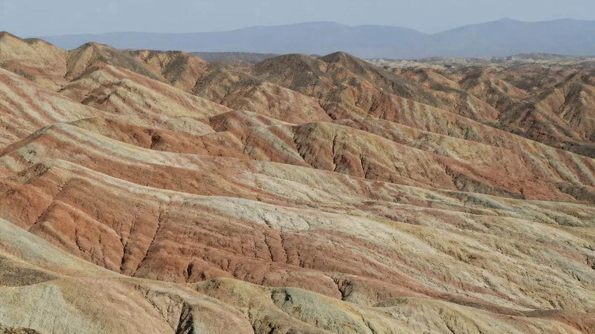
The striped hills west of Zhangye are the most photographed landform in northwest China, and they are marketed as Danxia — Seven-Colour Danxia, the Rainbow Mountains. In the strict language of Chinese geomorphology, the thing you have come to see is not Danxia. It is a coloured hill landform, a different category with different rock, a different erosional mechanism and a different shape. Real Danxia does exist inside the same geopark, about twelve kilometres away over the ridge, and hardly anybody goes.
This is not a pedantic footnote. Once you know which of the two you are standing in, the landscape stops being a mystery paint job and starts being readable.
What Danxia actually means
The term is Chinese in origin, introduced by geologists in the first decades of the twentieth century and named for Mount Danxia in northern Guangdong, which remains the type locality.
A Danxia landform has two requirements. The rock must be a continental red terrigenous bed — conglomerate, sandy conglomerate, sandstone — and it must be hard enough to stand up. The form must be cliffed: the classic Chinese description is flat on top, sheer in the body, gentle at the foot, producing red walls and scarps, and by erosion the pillars, towers, ravines and gorges that go with them.
The problem is that the definition has multiplied. Chinese reference works, including geological dictionaries, geographical terminology standards and tourism-geoscience dictionaries, give definitions that do not agree with one another; more than twenty distinct formulations have been counted. That slack is exactly what allowed the word to spread onto landscapes it does not describe.
Why the rainbow hills are not that
Take the two requirements and check them against what is in front of you.
Rock. The rainbow hills are developed on soft, fine-grained Cretaceous beds: mudstone, shale and siltstone, weakly cemented, easily weathered. Research puts the scenic strata at roughly the Early Cretaceous, with sedimentation dated in the range of about 135 to 96 million years, and total thickness of the fluvial-lacustrine red and variegated clastic sequence given as over 5,000 metres.
Form. Soft, fine rock does not hold a vertical face. It rounds. What you get is a field of smooth, undulating, close-packed ridges — visually spectacular, structurally the opposite of a cliff. Walk the platforms and try to find a genuine sheer wall of the Danxia type; you will not find one, and that absence is the whole argument.
So the naming has been criticised in print. One proposal is to treat these as a distinct subtype of red-bed landform, coordinate with Danxia rather than beneath it, under a name of its own; the same style occurs at several sites in Xinjiang and elsewhere in Gansu, so it needs a category. Another description in the literature, blunter, is badland-type coloured hills, in reference to the dense gullying, the salinisation and the near-total absence of vegetation.
Where the wrong name came from
There is a traceable origin, and it is almost banal.
In the 1990s the geographer Huang Jin, the leading authority on Danxia landform research in China and long a professor at Sun Yat-sen University, came to Zhangye. In 2005 he left an inscription. Read it carefully, because it is two statements, not one: Zhangye’s window-lattice palace-style Danxia landform is the finest in China; Zhangye’s coloured hills are the finest in China.
Two landscapes, two categories, correctly distinguished by the specialist who knew the difference better than anyone. Somewhere in the years afterward, the second phrase quietly borrowed the first phrase’s noun, and coloured hills became seven-colour Danxia. The misreading was then locked in by a film shoot — a 2009 Zhang Yimou feature was made here — and by a run of international listicles that put the “Rainbow Mountains” on the global itinerary. By the time anyone objected, the name was on the gate, the road signs and several million photographs.
The strata are a climate record
Here is what you actually gain by dropping the Danxia frame: the stripes become legible.
In the Cretaceous this basin held a long-lived lake and the rivers feeding it. Sediment accumulated in layers over millions of years, and the character of each layer depended on the climate and on the chemistry of the water at the time it was laid down. The colour is the trace of iron in two oxidation states.
- Where the environment was hot and dry and oxidising, trivalent iron dominates and the bed is red or purple-red.
- Where it was wet, cooler and reducing, ferrous iron dominates and the bed is grey-green, blue-grey or almost black.
- Yellow beds sit in between, recording the transition from humid toward arid.
Read as a sequence, the early Cretaceous here was arid or semi-arid and laid down red; the middle of the period alternated between dry and warm-humid, and it is that alternation that produced the interleaved red, purple-red, yellow-green, grey-green and grey-black mudstones stacked on top of each other. Other minerals contribute: manganese deepens some bands, gypsum and calcareous partings give the white and pale-yellow lines.
The rhythm on the hillside is not decoration. It is a few million years of climate oscillation, written in the order it happened.
The last piece of the mechanism is why you can see the layers at all. Lake sediments are laid down flat. These are not flat — they are inclined, sometimes steeply, which is what turns the stack into visible stripes running diagonally across a slope. The tilt is tectonic, and it comes from a long way off: the collision of the Indian plate with Eurasia and the rise of the Tibetan Plateau through the Cenozoic transmitted compression to the northern edge of the plateau, and Zhangye sits on that edge, at the foot of the Qilian Mountains.
The literature gives an approximate sequence. Late-stage Himalayan compression reaching the Qilian region around 8 million years ago uplifted, shortened and gently folded the beds; by the Pliocene, roughly 6 to 7 million years ago, the outline of the Danxia and coloured-hill landscape was in place; by the Middle Pleistocene, around 0.2 to 0.4 million years ago, it had essentially reached its present form. Faulting along the northern Qilian margin controlled where all of this happened.
Then erosion did the rest. Running water cut the gullies, wind scoured the surfaces, and the differential weathering of soft and slightly less soft beds produced the monoclinal ridges you are looking at. Tilted strata, stripped bare, in a place too dry to grow a covering of plants over them: that is the entire recipe.
The real Danxia is over the ridge
The geopark is a genuine composite, which is the fact that makes the naming confusion so unnecessary. It is usually described as comprising the coloured hills, the Binggou Danxia area and a Yugur cultural corridor, plus a scientific-study zone.
Binggou is the real thing. Its core sits in Sunan Yugur Autonomous County, and it preserves red sandy conglomerate beds of Early Cretaceous age, commonly given as about 145 to 100 million years. The forms are the ones the definition asks for: red cliffs and scarps, castellated isolated hills, and above all the window-lattice palace-style Danxia, faces fretted into what genuinely resemble lattice windows on the front of a palace, a style described as unique to Zhangye. Specialists call the wider area the most typically developed Danxia landform in arid northern China and the country’s only high-density composite of Danxia and coloured hills together.
It is about twelve kilometres from the rainbow area, sees a small fraction of the crowd, and requires its own ticket. If you have a spare half-day and any interest in the argument above, going to both is the only way to see what the two words mean.
The World Heritage listing you are not looking at
One more piece of housekeeping, because the word Danxia on the gate invites an assumption that is simply false.
China Danxia was inscribed on the World Heritage List in 2010 as a serial natural property, and it has six components, every one of them in the subtropical southeast: Chishui in Guizhou, Taining in Fujian, Langshan in Hunan, Danxiashan in Guangdong, Longhushan in Jiangxi and Jianglangshan in Zhejiang. They sit along a crescent roughly 1,700 kilometres from west to east. The nomination had originally proposed nine sites and was cut to six at a Beijing seminar in January 2009; the evaluation noted that Langshan and Danxiashan were considered the clearest demonstrations of the type.
Zhangye is not one of them, is not in a buffer zone of one of them, and is a couple of thousand kilometres from the nearest. What Zhangye holds instead is a different and perfectly respectable set of credentials: national 5A scenic area status confirmed on 7 January 2020, and UNESCO Global Geopark status granted by the UNESCO Executive Board on 7 July 2020, with the park formally opened that September. Reporting from June 2025 has the coloured hills entered on China’s tentative list for a future World Heritage nomination — the first step of a long process, not the last.
What the numbers do and do not agree on
Almost every area figure attached to this place has competing versions, so hold them loosely.
The geopark is given as 1,289.71 square kilometres in the UNESCO-era official material, while a planned area of 322 square kilometres and a figure of 510 square kilometres both remain in circulation from earlier designations. The rainbow scenic area is given as 50 square kilometres in some sources and about 54 in others, including in an official statement by the geopark administration. The coloured hills themselves are quoted at 30, 40, 54 and 55 square kilometres depending on whether you are counting the core, the developed area or the full outcrop. The composite Danxia-plus-coloured-hills geological heritage distribution is given as about 410 square kilometres. Binggou’s core concentration is given as around 30 square kilometres and its total area as 300.
None of these are wrong exactly; they are answers to different questions asked in different years. Cite the year and the basis, or do not cite the number.
The colour you will actually see
Now the honest part, because this is where visitors get let down.
There was a period of online rumour claiming the hills were artificially dyed. The geopark administration’s response was the correct one: the coloured hills spread across tens of square kilometres of terrain, and painting an area that size is not physically possible. Specialists add the harder point — the colour of the rock itself can be measured objectively by spectral analysis, so it is not a matter of opinion.
What is variable is what reaches your eye. Sun angle, humidity, cloud cover and season all change the apparent saturation dramatically, and the images that brought you here have almost all been pushed in editing, often well past the point where a sky stops looking real.
The practical rules follow directly:
- Do not go at midday. High sun and dusty air flatten the bands into a pale wash. This is the single largest cause of disappointment, and it is entirely avoidable.
- Go low. The hour before sunset and the period just after sunrise are when the bands separate and the reds come up.
- Prefer broken cloud to a cloudless sky. Moving light gives the ridges shape; flat blue does not.
- Chase rain. Wet rock is more saturated, and the day after a rain is widely held to be the best condition here.
- Reset the expectation. What you are looking at is a stratigraphic section, magnificent on its own terms. It is not a paint box, and it will not match the phone screen that sent you.
Practicalities, with the usual warning
The rainbow area lies about thirty kilometres west of central Zhangye, in Linze County, on the northern flank of the Qilian range and within reach of the Hexi Corridor route that also carries Jiayuguan and Dunhuang.
Inside, the site is a shuttle-and-platform system: an included bus circulating between numbered viewing platforms, free to board and leave at each one, and a circuit that most people complete in about an hour and a half. There are several gates and the bus order depends on which one you used. One platform is the high panorama and involves a long stair climb. Another is generally agreed to be the best single view, with a wide field of red waves against pale ridges, and it fills up before sunset.
Everything in that paragraph is subject to change, and different sources already contradict each other on which numbered platform is which. Treat platform numbers, gate assignments, shuttle routing, opening hours, re-entry rules and prices as same-day information. Read the map at the gate. There is no shade on the platforms and no water for sale on them, so bring both sun protection and a bottle.
Say the right word, see the right thing
The most useful thing you can carry up to the first platform is one sentence: these are coloured hills, and the Danxia is over there.
Say it and the whole scene reorganises. The rounded ridges stop looking like a failed version of a cliff landscape and become exactly what soft mudstone does. The stripes stop being a colour trick and become a lake’s climate diary, tipped up on end by a mountain range rising two thousand kilometres away. The absence of a single sheer red wall stops being an oversight and becomes the diagnostic evidence.
And the misnaming stops being an embarrassment, because it has a clean history: a specialist wrote down two correct phrases in 2005, the tourism economy fused them into one wrong one, and nobody had a commercial reason to fix it. The rock never claimed anything. It just kept a record of what the weather was doing a hundred million years ago and waited for someone to tilt it into the light.
The LoreLens app can help you identify red-bed strata, coloured-hill and Danxia landforms and the tectonic structures behind them while explaining how they formed.
Location profile
Where it is

Frequently asked questions
Is Zhangye's rainbow landscape actually Danxia?
Strictly, no. Danxia landform is defined on relatively hard red terrigenous beds, mainly conglomerate, sandy conglomerate and sandstone, and its diagnostic feature is the cliff: red walls and scarps, the flat-topped, steep-sided, gentle-footed profile. The striped rainbow hills that everyone photographs are developed on soft, fine-grained Cretaceous mudstone, shale and siltstone, which erode into smooth rounded ridges and essentially cannot hold a cliff. In Chinese geomorphology those are coloured hills, a separate category, and specialists have argued for giving them a name of their own as a sibling subtype of red-bed landforms rather than a branch of Danxia. The scenic area does contain real Danxia, but that is the Binggou section over the ridge, not the rainbow one. Note also that the site's own official material has historically described the rainbow area as coloured-hill landform in the small print while the brand on the gate says Danxia.
Is Zhangye part of the China Danxia World Heritage Site?
No. China Danxia was inscribed in 2010 as a serial natural property of six components, all in subtropical southeastern China: Chishui in Guizhou, Taining in Fujian, Langshan in Hunan, Danxiashan in Guangdong, Longhushan in Jiangxi and Jianglangshan in Zhejiang. Zhangye is not among them and is not in the buffer of any of them. What Zhangye does hold are different designations: national 5A scenic area status confirmed in January 2020, and UNESCO Global Geopark status granted by the UNESCO Executive Board in July 2020, with the park formally opened that September. Reporting in June 2025 also placed the Zhangye coloured hills on China's tentative list for a future World Heritage nomination, which is a starting line rather than an inscription.
Will the colours look like the photographs?
Usually not, and it is better to know that going in. The rock colour is real and can be measured objectively by spectral analysis, but what your eye receives depends on sun angle, humidity, cloud and season, and most images in circulation have been pushed hard in editing. The practical consequences are simple. Avoid the middle of the day, roughly from late morning to late afternoon, when high sun and haze flatten everything into pale grey-pink; that single mistake accounts for most disappointment reported by visitors. Low sun in the hour before sunset is the reliable window, broken cloud beats a cloudless sky because it gives the ridges modelling, and the day after rain is the best colour of all. Photographers who have shot here at noon describe the result as visibly duller than expected, so treat this as a geological section you are reading rather than a paint box.
How does the site work on the ground, and how long does it take?
The rainbow area is arranged as a set of numbered viewing platforms linked by an included shuttle bus that circulates between them, with free hop-on and hop-off; there are multiple gates, and which platform the bus reaches first depends on which gate you entered. Allow around an hour and a half to two hours for a full circuit, longer if you wait out a sunset. One platform is the highest and requires a substantial stair climb for the panorama; another is generally agreed to hold the best single view, and people arrive early to hold a spot for sunset. Platform numbering, names, gate assignments and shuttle routing are all adjusted from time to time and different write-ups contradict each other, so read the site map on the day rather than a numbered plan from an article. There is essentially no shade and no water on the platforms, so carry your own. The Binggou Danxia section is a separate area about twelve kilometres away with a separate ticket.
Sources and further reading
Background references for the history and place names in this guide. Opening hours, ticketing and access change often — always confirm with official local information before travelling.