Gansu · Dunhuang
Mingsha Shan and Crescent Lake: The Sand Was Never the Threat
Every visitor asks why the dunes have not buried the spring. The wind has a real answer. The harder truth is that the spring nearly died anyway, from underneath, and that both the sand balance and the water balance are now things people maintain on purpose.
5A View location, maps and nearby scenic areasEveryone asks the same question walking in, and it is a good question.
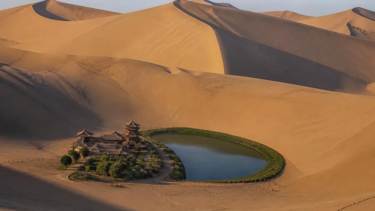
The dunes here stand more than a hundred metres above the flat, and the leading edge of the sand comes within a few dozen metres of the water. A pool that shape, in a bowl that shape, should have been filled in centuries ago. Chinese sources have been noting for a very long time that it has not been: through the ages, the phrase goes, the sand does not fill it.
There is a real answer, and it is about wind. But the question turns out to be aimed in the wrong direction. Crescent Lake was never seriously threatened from above. It was nearly destroyed from below, within living memory, and what saved it was not physics but policy.
A bowl, three winds, and sand that travels uphill
Start with the geometry, because the geometry does the work.
The spring lies in a ring-shaped hollow. The dunes around it are given a relative height of more than 100 metres, with the highest ground reported at around 170 metres, and the shapes of the enclosing slopes are not symmetrical: meteorological descriptions note that the northern face of the southern dune bulges outward while the southern face of the northern dune curves inward, which is what gives the pool its crescent outline in the first place.
Air entering that bowl through the gap does not behave like air on the open desert. It accelerates, splits into separate streams, and runs centrifugally up the inner slopes, lifting sand from the base and carrying it toward the crest, where it is thrown over onto the far side. Sand near the water goes up and out rather than in.
Two treatment specialists who joined a joint sand-control group here in 1990, Han Zemin and Lü Aixiang, put it in the plainest terms after tracking sand paths on the ground: the wind outside the spring basin and the wind inside it are not the same wind. The basin is a natural vortex field, and everything in it moves upward.
Star dunes stay where they are
The second half of the mechanism is about dune type rather than airflow.
Where a single dominant wind blows, dunes are asymmetric and migrate downwind: that is how a barchan field advances across a road or a field. Where sand arrives from several directions in comparable amounts, the transport vectors largely cancel. The dune grows taller instead of moving, developing radiating arms—the pyramid or star dune form that dominates this part of the Mingsha massif.
Dunhuang’s official material describes the local equilibrium as depending on three interacting wind directions. That is the honest version of the marvel. The spring is not protected by a miracle; it sits at the centre of a sand budget that happens to balance.
Budgets can be spent.
The balance broke, and someone had to fix it
By the early 2000s monitoring showed the dunes closing in: the northern dune moving south, the southern dune moving north, tightening on the spring.
From 2008 a team led by Qu Jianjun of the Chinese Academy of Sciences worked the problem with the whole toolkit—regional circulation analysis, local airflow observation, sand-activity monitoring, dune morphometry, wind-tunnel experiments and numerical simulation—in cooperation with the scenic area’s managers. The Dunhuang Gobi Desert Ecology and Environment Research Station and the site jointly established fixed observation points.
The diagnosis was not climate. It was obstruction. Tall trees planted around the spring and structures built upwind had blocked and weakened the northeasterly component, breaking the balance among the three transport directions, suppressing the natural sand-moving flow field and deforming the pyramid dunes that had previously held station. Remove one leg of a three-legged equilibrium and the dunes start walking.
The threat of burial is described as having been lifted. Note what that sentence contains: the reason the sand never buried Crescent Lake is a natural mechanism, and the reason it still has not is a piece of active management.
The spring is a window onto a water table
Now turn the question upside down, because this is where the real jeopardy was.
Crescent Lake is not a pond that collects rain and is topped up by seepage from the dunes. Between 1997 and roughly 2002, specialists from a Gansu geological-hazard engineering institute investigated the origin over five years and concluded that the spring sits in the depression between two alluvial fans, the Danghe fan and the Xishuigou fan, and that it exists because the regional water table there stands above the ground surface. The pool is an outcrop of the aquifer. Earlier hypotheses—fault spring, wind-scoured lake, relict river channel, fissure spring—had circulated for decades and are now superseded rather than confirmed.
The Danghe is the only river flowing through the Dunhuang basin and the principal source of that groundwater.
The implication is uncomfortable and completely determinative. Nothing that happens on the dune above the spring affects its level. What sets the level is how much water reaches and stays in the aquifer several kilometres away, which is a function of a reservoir, an irrigated oasis, a population and a well count.
The numbers of the shrinking, with their years attached
The decline is well documented and badly quoted, because different sources mix average depth with maximum depth and different measurement years. Here is the spread, dated.
Around 1960, one line of accounts gives an average depth of 4 to 5 metres with a maximum of 7.5 metres; another gives a maximum of 9 metres and a water area of 22.5 mu, roughly 1.5 hectares; a third describes about 14,500 square metres at 7.5 metres deep; a Xinhua account says the water area was still over 30 mu, about two hectares, in the 1960s. These are not reconcilable as written.
What follows is consistent in direction. By 1985 the average depth was 0.7 to 0.8 metres, the pool had split into two and lost its crescent shape, and the area was about 6.9 mu. Dredging in 1987 brought it back to 4.2 metres and 13.5 mu. By April 1997 it was down again to 1.3 metres and 8.69 mu. In 1999 the bed was exposed in places and the average depth is given as 0.4 metres, with the low point of area cited at about 2.56 mu, well under two thousand square metres. In 2004 the figure quoted is 1.3 metres and 7.8 mu.
The rates are the clearest summary: an average fall of 22 centimetres a year from 1986 to 1996, and 40.1 centimetres across 1997 to 1998. Contemporary reporting at the time warned that on that trajectory the spring had only a few years left.
Do not quote any of these without a year.
Why it fell: a reservoir, an oasis, and a lot of wells
The causes are not mysterious and are stated openly in Chinese official and academic material.
The Danghe reservoir, completed in 1975, greatly reduced groundwater recharge upstream of the spring by capturing the surface flow that had been infiltrating along the river bed. At the same time Dunhuang’s population grew, cultivated area expanded, and when the main canal could not supply the irrigation demand, villagers drilled wells. Groundwater abstraction rose, the regional table fell, and the window in the sand fell with it.
There is an earlier and more direct injury on the record too: in the 1960s and 1970s the spring’s own water was used for irrigation to the point that little was left, and water quality problems followed. A Lanzhou University researcher has argued that over-abstraction of groundwater and the resulting deterioration of the surrounding water environment was the more important factor of the two.
None of this needs a villain. It needs an accounting.
Three attempts to refill a spring
The remedies form a sequence, and the sequence is instructive because the first one failed in a way that clarified the problem.
1986: dredge and pipe. A restoration office was set up in Dunhuang, silt was cleared, and Danghe water was routed through a settling basin and piped directly into the spring. Depth reached 4.2 metres. The water turned turbid and eventually foul, and the practice was stopped—whereupon the spring shrank again. The lesson: you can raise a water level without repairing a water table, and it does not hold.
1990s to 2008: restriction and infiltration. From the late 1990s Dunhuang limited groundwater extraction upstream and around the spring, pushed water-saving agriculture, and from 2000 used emergency river-water recharge nearby. In 2007 a treatment plant and a large underground infiltration field were built some kilometres west, purifying Danghe water and letting it soak down to reach the spring through the aquifer instead of through a pipe. The emergency works came partly into use in March 2008, and the average level rose by about 30 centimetres from roughly a metre.
2016 to 2018: the recovery project. Construction ran from October 2016 to July 2018. Low weirs increased infiltration of surface water; a longitudinal dike split the Danghe bed lengthwise into a flood channel on one side and an infiltration field with 12 seepage ponds on the other; extraction inside the spring’s catchment was further restricted to lift the water table in key upstream zones. Average depth reportedly went from about 1.35 metres to around 1.60 metres, and as a side effect 7.3 kilometres of river channel had its flood protection raised from a five-year to a fifty-year standard. The stated target was to bring the spring back above 2.0 metres and restore the crescent outline.
Where it stands now, and what “now” means
Recent reporting is positive and not perfectly consistent, which is normal for a figure that moves every season.
A Xinhua report in 2024 described the observed level as having stabilised at around 3.2 metres in the preceding two years, with the water area steady at 27 mu, roughly 1.8 hectares, and noted that in August to October each year, as evaporation drops, the level rises enough to overflow at the two ends. 2026 reporting on a decade of works describes a cumulative rise of 2.5 metres over ten years, an area increase from under 8 mu to about 30 mu, and water quality held at national Class II.
Behind the numbers is a monitoring programme: a detailed groundwater assessment across roughly 200 square kilometres around the spring, and more than twenty dynamic monitoring boreholes. Alongside it sits a blunt local policy summarised as three prohibitions—no new land reclamation, no new wells, no in-migration—together with programmes to replace municipal groundwater sources and cut total abstraction.
So the crescent you photograph is real, and it is roughly twice the size it was fifteen years ago, and it is that size because a district agreed not to drill.
Why the sand sings, and why it stopped for a while
The other famous property of this place is less settled than the water story, and honest sources say so.
Three classical explanations circulated for most of the twentieth century. Friction: dry, hot grains rubbing as they avalanche. Static or piezoelectric discharge: quartz grains charging as they slide, with a Soviet researcher reportedly producing artificial singing sand by washing river sand and charging it. Resonance: the valleys between dunes acting as a natural sound box amplifying whatever the grains produce. Even within the resonance camp the box was placed differently—Marikovsky put it in a buried damp layer inside the dune, while the Chinese researcher Ma Yuming argued in 1979 that it lay in the air above the surface, and others located it in the shifting pore space between sliding grains.
None of these settled the matter. Ralph Bagnold, the founder of aeolian physics, is said to have kept two jars in his laboratory for years, one of glass beads and one of singing sand, and never resolved it.
The explanation now widely accepted in China came from Qu Jianjun and was published in 2012: the key is a resonant cavity formed by the pitted, porous surface texture of naturally weathered grains, working on a principle akin to a Helmholtz resonator. Glass beads given an artificially pitted surface acquired the precondition for sound. The associated conditions are that grain size is uniform, the dune is tall and steep, and the slip face sits at the angle of repose, roughly 28 to 32 degrees. Dull sand, by contrast, is poorly sorted and clay-rich; the Taklamakan is quiet because basin dust coats and destroys the surface structure.
Around 1994 the dunes here largely fell silent, and the cause given is over-concentrated sand sledding generating dust on a handful of slopes. Closure and rest restored the effect. The loudest sound recorded in official material is 83 decibels.
Whether the pitted-cavity account is the whole story internationally remains open; other lines of research emphasise shear-layer dynamics within an avalanching flow. Take it as strongly supported and not closed.
Two names, one oasis, and how to use a day
The names on the map are older than the road to them, and worth having in order.
The dunes were called Shensha Shan and Shajiao Shan in the Han period and became Mingsha Shan, singing sand mountain, by the Wei and Jin—the old name of Dunhuang, Shazhou, sand prefecture, comes from the same feature. The massif runs about 40 kilometres east to west, from the Mogao area to the mouth of the Danghe, and about 20 kilometres north to south, with a main peak reported at 1,715 metres. The sand is described locally in five colours, and the local three treasures are the five-coloured sand, the iron-backed fish and the seven-star grass.
The pool below was Shajing, the sand well, in the Han; Yaoquan, the medicine spring, in the Tang; and only from the Qing has it been Yueyaquan, crescent moon spring. A Chinese-language encyclopedia entry also lists Wowachi among its old names, but that name is usually attached elsewhere in the Dunhuang area, so treat the identification as unconfirmed. The Dunhuang County Gazetteer counts two of the eight views of Dunhuang here: the sand ridge sounding in clear weather, and the moon spring at dawn.
The oldest description quoted on official signage comes through the fragmentary Han-period Records of the Three Qin, which speaks of a Hexi sand-horn mountain of coarse yellow grains where a climber hears drums and horns underfoot—and the companion observation that after a night of wind the slope is restored as it was. That last line is still accurate, and it is the reason a slope crossed by ten thousand feet looks untouched the next morning.
Two practical notes to close on. The Mogao Caves are also in Dunhuang, also unmissable, and not part of this scenic area at all—they sit outside the national 5A directory entirely, being administered through the cultural-heritage system, with their own reservation regime. And everything about a visit here that involves a number—ticket price, opening hours, which slopes are open, whether camels or sledding are running, how high the water is standing—is a function of this season rather than this article. Confirm it at the gate.
The LoreLens app can identify dune types, desert spring landforms and oasis vegetation while explaining the aeolian processes behind them.
Location profile
Where it is

Frequently asked questions
Why doesn't the sand bury Crescent Lake?
Because of the shape of the hollow the spring sits in and the wind regime above it. The spring lies in a bowl ringed by dunes rising more than a hundred metres, with the highest ground reported at around 170 metres. Air entering the bowl is accelerated and split, and it moves centrifugally up the inner slopes, carrying sand from the foot of the slopes upward and throwing it over the crest rather than into the water. Sand transport from several prevailing directions cancels out, so the surrounding star or pyramid dunes grow in place instead of migrating, and the classical phrase for it in Chinese sources is that through the ages the sand does not fill it. The important qualification is that this balance is not indestructible. From the early 2000s the northern dune was observed moving south and the southern dune north, and research from 2008 onward attributed the change to tall trees and upwind structures damping one of the three wind directions. The equilibrium was restored by managing the obstacles, not by luck.
Is Crescent Lake drying up?
It very nearly did, and it has been partially recovered. The decline was not caused by sand but by groundwater. The spring is regional groundwater surfacing in a low point between two alluvial fans, recharged mainly through the Danghe, and once the Danghe reservoir was completed in 1975 and irrigation and well pumping expanded around Dunhuang, the water table fell and the spring fell with it. Reported figures differ by source and measurement basis, but the direction is unambiguous: around 1960 accounts give an average depth of four to five metres with a maximum of 7.5 metres, or a maximum of nine metres; by 1985 the average was down to 0.7 to 0.8 metres with the pool split in two and the crescent shape lost; in 1999 the average is given as 0.4 metres. The level fell by an average of 22 centimetres a year between 1986 and 1996. Recovery has come from recharge works and pumping restrictions, and recent reporting describes roughly 2.5 metres regained over a decade. Always quote these numbers with their year.
Are the Mogao Caves part of this scenic area?
No, and the confusion is common because both are in Dunhuang and both are on most itineraries. Mingsha Shan and Crescent Lake are a single national 5A scenic area a short drive south of the town. The Mogao Caves are managed by the Dunhuang Academy under the cultural-heritage system and do not appear in the national 5A directory at all, which is a checkable fact rather than a judgement about their importance: the caves are a UNESCO World Heritage property and among the most significant Buddhist cave complexes anywhere, they are simply not administered through the tourism grading scheme. Practically this means separate tickets, separate booking systems, separate visitor caps and separate opening rules, and the caves in particular operate a timed-entry reservation system that sells out in season. Treat them as two trips on the same day, not two halves of one site.
When does the sand actually sing, and how long do I need here?
The sound is associated with dry, clean, well-sorted sand sliding on a steep face, and it is reported from the slip faces at the angle of repose, roughly 28 to 32 degrees, in dry weather. Measurements cited in official material put the loudest reported sound at 83 decibels. It is not guaranteed on any given visit, and it stopped almost entirely around 1994, when heavy sand sledding concentrated on a few slopes generated dust that degraded the grains; the effect was reversed by closing and resting the affected dunes. For time, half a day covers the walk to the spring, a climb of the dune above it and a return, with camel trains, sledding and vehicle tours available as add-ons. Late afternoon into evening is the usual recommendation for light and for heat. The scenic area has run extended evening hours in summer, but hours, ticket validity, which activities are operating and which slopes are open all change by season, so confirm at the gate on the day.
Sources and further reading
Background references for the history and place names in this guide. Opening hours, ticketing and access change often — always confirm with official local information before travelling.