Gansu · Pingliang
Kongtong Mountain: Cliffs, Temples and the Art of Asking
Begin on Zhongtai, where Buddhist courtyards meet the stairway to Taoist halls, then choose a higher ridge without mistaking a philosophical legend for a historical encounter.
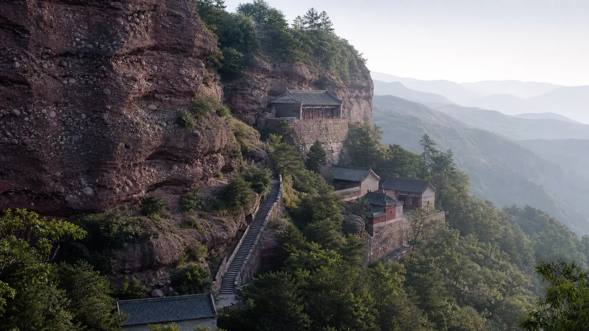
5A View location, maps and nearby scenic areasAt Zhongtai, stop where the open terrace narrows into stone steps. A bell or chanting may drift from a Buddhist courtyard behind you; ahead, Chaotian Gate and the steep Shangtianti stairway pull the eye towards Daoist halls on the ridge. Red-brown rock appears between trees, and roofs seem to occupy ledges rather than a single summit.
That junction is the best introduction to Kongtong Mountain—Kongtong Shan, roughly “koong-tong shahn.” It is a mountain landscape close to Pingliang, a working religious environment and a managed scenic area whose paths connect different periods and traditions. It is often listed among China’s prominent Daoist mountains. That importance does not turn the promotional title “the first mountain of Daoism” into a verifiable rank or make this the documented birthplace of an entire religion.
Read the mountain in three layers: Zhongtai is the practical interchange and Buddhist centre; the stair-and-ridge circuit leads towards Daoist spaces such as Huangcheng; Xiangshan and the lower gates add distance, height and a different return problem. Decide the way down before climbing up.
A mountain map written in cliffs and terraces
Kongtong rises west of central Pingliang, on the eastern side of Gansu and within the wider Liupan mountain system. Local management descriptions commonly give the scenic area as about 84 square kilometres and place its highest ground at roughly 2,100 to 2,123 metres. Published names for the highest point are not consistent: Cuiping Peak, Xiangshan and other summit labels can refer to different mapped units or visitor zones. Treat the number as an orientation to scale, not a promise that one signed viewpoint is the mountain’s single definitive top.
The cliffs are built largely from hard purple-red conglomerate. Uplift, water and weather opened gullies and left flat or rounded tops above steep faces—forms local geological interpretation places within an old Danxia-type landscape. The useful field evidence is in front of you: pebbles bound into the rock, horizontal colour changes, runoff channels and abrupt walls below greener platforms. Claims that this is “the oldest” example depend on how rock age and landform age are defined and should not be repeated as a simple superlative.
Water changes the approach. The front route meets the reservoir landscape commonly called Tanzheng Lake, while upper paths can feel surprisingly enclosed by forest. A lake surface, a cliff face and a temple terrace are different scales within one visit. The protected scenic area is broader than any single summit, and the current entrance map remains essential for knowing which paths and transport links are actually open.
What the Zhuangzi story really asks
The mountain’s most famous encounter comes from the “Zai You” chapter of the Zhuangzi, a foundational collection of Daoist philosophical literature compiled from texts of different hands and periods. In the story, the Yellow Emperor hears that the recluse Guangchengzi lives “above Kongtong” and asks how to control the essences of heaven and earth, order yin and yang, nourish crops and govern living things.
Guangchengzi refuses the premise. The ruler who wants to manage every rhythm, he says, has already made rain fall out of season and plants wither too soon. The Yellow Emperor withdraws from government, sits alone for three months and returns with a humbler question about cultivating himself. Only then does the teacher rise and answer. One central line is:
“Do not look, do not listen; hold the spirit in stillness, and the body will right itself.” — Zhuangzi, “Zai You”
The quotation, story and modern echo belong together. This is not a transcript recovered from an excavated meeting room, nor does the ancient text supply coordinates proving that its Kongtong is this precise mountain. Later geography, religious institutions, paintings and local memory gave the literary scene a home near Pingliang. Today “asking the Way” survives in place-names, monuments and visitors who arrive with questions of their own. The story’s turn—from controlling the world to examining the self—is more interesting than using it as a certificate of origin.
Daoist, Buddhist and other layers share the route
Upper Kongtong’s best-known ritual spaces are Daoist. Huangcheng, associated with the Taihe Palace complex and the worship of Zhenwu, uses gates, courtyards and a commanding ridge position to create a sacred ascent. Other halls and shrine names evoke the Queen Mother of the West, Guangchengzi and immortality traditions. Their present rituals, incense and caretaking matter as much as the stories attached to their names.
Yet the day commonly begins among Buddhist monasteries at Zhongtai. Bells, images, vegetarian food or a service may belong to Buddhist rather than Daoist practice. At Sanjiao Cave, the language of the “Three Teachings” brings Confucian, Buddhist and Daoist figures into a shared cultural frame. That does not mean their doctrines were identical or that coexistence was always frictionless. It shows how Chinese sacred landscapes could accumulate patronage, images and local interpretations without being owned by one label alone.
Imperial memory, local folk devotion, inscriptions, martial-arts performance and modern tourism add further layers. A guide may call every religious building a “temple” in English, but the Chinese terms distinguish Buddhist si and yuan, Daoist gong and guan, caves and popular shrines. Read the nameboard before assigning a tradition, and let a worshipper’s behaviour tell you whether a space is active.
An old institution does not mean an untouched building
Accounts of Kongtong trace religious activity through many dynasties, but surviving fabric is not a continuous museum of ancient timber. Fire, weather, warfare, political campaigns, neglect and repair repeatedly changed the mountain. A Gansu provincial religious gazette records severe losses to images, ritual objects and religious life in the mid-twentieth century, followed by the restoration of activity and substantial rebuilding after the reform era.
That history should remain visible. A monastery may preserve an old name while its main hall is a recent reconstruction. A gate can reuse an earlier plan; a painted beam may belong to the latest conservation campaign; a plaque may commemorate the donor or year of a rebuilding rather than an original foundation. Local descriptions explicitly include newly built or restored sites among the recovered “palaces, terraces and courtyards.”
Look for dated inscriptions, replacement stone, differently weathered roof tiles, modern concrete hidden beneath traditional profiles and conservation notices. Ask separately: When did the religious institution begin? When was this structure built, and when was it last repaired? A rebuilt hall is not culturally empty—it can hold living worship—but calling it an untouched Tang or Ming building erases the workers and upheavals that produced what stands today.
The mountain is maintained work, not a painted backdrop
Before the first large groups arrive, cleaners sweep needles from wet steps, monastics and lay caretakers open halls, drivers inspect vehicles, cooks lift steam from breakfast pots and maintenance crews check railings. Porters and shop workers move food and water uphill; staff carry waste back down. The quiet visitors value is made by other people’s labour.
Tourism supports livelihoods around Pingliang while adding pressure: vehicle traffic, water use, packaging, noise, incense smoke and fire risk. Current visitor notices describe Kongtong as a protected natural area and commonly prohibit smoking and open flame. Rules concerning incense, lighters, pets and food can change, so follow the present gate notice rather than assuming religious custom overrides fire control.
Carry a refillable bottle where permitted, keep snack wrappers until a proper bin, and do not wedge tissues into rock cracks. Stay on marked paths instead of widening shortcuts through vegetation. Do not feed wildlife or pick plants. If a hall offers incense, use the designated amount and burner; more smoke is not more respect. Conservation here has to serve forest, conglomerate cliffs, religious communities and local employment at the same time.
Make Zhongtai the centre of a first visit
For most first-time visitors, a selective Zhongtai loop gives the clearest story. When the scenic shuttle is operating, riding from the visitor-centre or Kongtong Ancient Town area to Zhongtai saves energy for the meaningful steps. Begin with the Buddhist courtyards. Notice how their more level sequence occupies the terrace before the route pinches upwards.
Continue through Chaotian Gate and take Shangtianti slowly. The name means “ladder to heaven,” but the danger is ordinary gravity: steep, sometimes narrow stone, people stopping suddenly and polished surfaces after rain. At Sanjiao Cave, pause over the juxtaposition of traditions rather than treating the interior as a stamp on a checklist. Proceed to Huangcheng only if weather, knees and time remain sound.
A useful return turns towards Leisheng Peak and descends to Zhongtai, creating a circuit rather than retracing every stair. Directional access can be altered by maintenance or crowd control. Confirm the loop on the day’s map and ask whether any section is one-way. Zhongtai is also the decision point where a shorter visitor can stop with a complete experience instead of measuring the mountain by its highest reachable roof.
Xiangshan, lower gates and the return you choose first
A longer itinerary extends from Huangcheng towards Xiangshan, or starts from a higher vehicle stop and works down through the ridge complex. This can reduce ascent while increasing the temptation to linger beyond the final transport. Scenic buses to Zhongtai or Xiangshan operate according to season, weather, road controls and demand. Any published last departure is a condition to reconfirm, not a permanent fact.
The east or rear approach commonly uses Phoenix Ridge to reach Zhongtai and is promoted as a shorter walking entry. The south or front approach connects the mountain with Tanzheng Lake, Wangmu Palace and a longer climb. Walking times on signs or apps assume particular gates, fitness and conditions; wet stone, queues and photography can make them poor promises.
Where a cableway or ropeway is offered, verify both terminals and the return arrangement. It may remove one climb without delivering you to every upper hall. A full traverse can leave you at a different gate from your luggage, hotel transfer or parked vehicle. Save the official transport number offline, allow a generous buffer before the last shuttle or ropeway, and keep a worthwhile out-and-back plan for days when upper services are suspended.
Respect the weather, the edge and your own limits
Kongtong is not extremely high, but its stairs accumulate effort. Carry water, a light layer and rain protection; use shoes with grip rather than smooth city soles. In summer, heat in sheltered sections can give way to wind and a thunderstorm on the ridge. Leave high platforms when thunder approaches, avoid lone trees and metal railings, and follow staff towards appropriate shelter.
Rain turns steps, roots and painted paving slick. Freeze-thaw weather brings snow and hard-to-see ice; it can also loosen stone. Never enter a closed cliff section, wait below a fresh rockfall scar or climb a barrier for a shortcut. After heavy rain, snow or strong wind, accept that an upper route may close even when the lower gate remains open.
A vehicle to Zhongtai creates the least strenuous version, not a fully accessible one. Historic thresholds, uneven paving, narrow gates and unavoidable steps remain; Huangcheng, Shangtianti and ridge circuits are generally unsuitable for wheelchairs. Ask the visitor service about current accessible drop-off points, toilets, wheelchairs and staff assistance before buying a route. Visitors with limited mobility can still build a meaningful lower-terrace visit if the plan values courtyards and views over completion.
Photograph relationships without interrupting ritual
At Zhongtai, step back far enough to place a courtyard roof against the red-brown cliff; the relationship explains more than an isolated façade. From an authorised ridge viewpoint, use a stair, wall or pine in the foreground to show how architecture negotiates the slope. Mist can separate roof layers, while clear late light reveals conglomerate texture. Never stand in a stair flow or on an exposed edge to compose the frame.
Inside religious spaces, the current sign and the officiant’s request take priority. Avoid flash and tripods unless explicitly allowed. Ask before photographing monastics, priests, worshippers, workers or children; do not frame a person at prayer as exotic scenery. Step around, not across, someone bowing. Do not touch images, bells, painted beams or cliff inscriptions, and do not assume a drone is legal in a protected and religious landscape.
Photograph one date plaque or repair notice as well as the grand view. It will remind you that the roofline is an argument across time, not a frozen “ancient China.” When the light fades, return to Zhongtai and listen once more: a Buddhist bell below, Daoist halls above and shuttle brakes at the edge of the terrace each belong to a different rhythm.
Kongtong’s lesson is not that one tradition began here or defeated all rivals. It is that a literary question found a mountain, communities rebuilt sacred space after loss, and visitors can still choose inquiry over conquest. Use the Kongtong Mountains 5A profile and map for its location and nearby scenic areas. Then compare Guan’e Valley, another Gansu landscape shaped by water, geology and community; Mount Wutai, a larger living pilgrimage system; and Mount Song, where religious history must likewise be separated from global legend.
Use the LoreLens app to identify Kongtong Mountain’s halls and cliffs on site, then hear the longer human stories behind what your camera sees.
Location profile
Where it is

Frequently asked questions
How much time should I allow for Kongtong Mountain?
A focused day can cover Zhongtai's Buddhist courtyards and a selective upper circuit through Chaotian Gate, Shangtianti and Huangcheng, returning via Leisheng Peak. Adding Xiangshan or a full ascent from a lower gate needs more time. Confirm current gates, transport and last departures, and keep enough daylight for a slow descent.
Did the Yellow Emperor really meet Guangchengzi on Kongtong Mountain?
The meeting is a philosophical story in the Zai You chapter of the Zhuangzi and related later traditions, not an archaeologically documented interview. The text places Guangchengzi 'above Kongtong' without modern coordinates; later communities associated that literary geography with the mountain near Pingliang.
Can I avoid most of the climbing by shuttle or cableway?
A scenic shuttle commonly connects the visitor-centre area with Zhongtai or a higher stop when operations permit, and a ropeway may appear among current options. None makes the historic core fully step-free: thresholds, uneven paving and steep flights remain. Verify terminals, accessibility assistance and return service on the day.
What are the main weather and trail risks?
Rain makes the stone stairs slick, thunderstorms expose ridges and high platforms, winter snow creates hidden ice, and freeze-thaw or heavy rain can increase falling-rock risk below cliffs. Wear grippy shoes, obey closures, avoid exposed ground in thunder and turn back before the final operating departure.