Jiangsu · Suqian
Hongze Lake: The Wetland That Was Engineered
One hundred and ninety-four species of bird, a thousand and eight varieties of lotus, and a reed maze on the northwest shallows of China's fourth-largest freshwater lake. The lake is not natural. It was raised above the surrounding farmland on purpose, in the sixteenth century, to keep the Grand Canal working — and in 1680 it drowned a city of nine hundred and forty-five years.
5A View location, maps and nearby scenic areasThe visitor material for the wetland at Sihong lists the things you would expect. One hundred and ninety-four species of bird. A garden holding 1,008 varieties of lotus. A maze cut through standing reeds. A corridor of trees where the air is measured at twenty to fifty thousand negative ions per cubic centimetre, which is the kind of number Chinese wellness tourism runs on. Water at national Class II. Metasequoia you punt through on a bamboo raft.
All of it is real. None of it is natural.
Hongze Lake is roughly four hundred and fifty years old. It exists because the Yellow River took the Huai River’s channel away from it in 1194, and because a Ming official decided in 1578 that the resulting flood should be dammed and kept, at a level higher than the farmland behind the dam, in order to flush silt out of the Grand Canal. The birds are living on the consequences of a hydraulic decision. Everything in this article follows from that.
What was here before
Not much, and that is the point.
The right bank of the Huai in this stretch was low, wet ground holding a scatter of shallow lakes and ponds with their own names — Pofu, Baishui, Nidun, Fuling. They were separate bodies of water in a floodplain, not a lake.
People had been trying to manage them for a very long time. Between 196 and 200 CE, Chen Deng, prefect of Guangling, built an embankment east of Pofu Pond to hold irrigation water. It was known anciently as the Huai-Warding Dyke and ran about thirty li. That structure is the direct ancestor of the seventy-kilometre masonry wall that holds the modern lake — which means the dyke is roughly eighteen hundred years old in its earliest form, and has been continuously rebuilt ever since.
A generation or so later, under the Wei, the general Deng Ai developed Baishui Pond into an irrigation and military-colony system: three embankments, eight water gates, forty-nine garrison settlements, and — in the figure the records give — twelve thousand qing under water.
So this was managed agricultural land, drained and irrigated, for about a thousand years before it became a lake.
The ape named after the god of wine
Before any of the hydraulic history, this lakeshore was a lacustrine sediment basin, and it has turned out to be one of the richest fossil beds in eastern China. More than seventy fossil species have come out of Sihong county, including close to a hundred Pleistocene and Miocene vertebrates, many of them new to science. Chinese palaeontologists refer to the assemblage as the Xiacaowan fauna, and to the county, with some affection, as a treasury of fossil apes.
Two finds matter, and the way they have been retold is a case study in how a fact becomes a slogan.
The first is genuine and important. In June 1954, during the Huai River control works, the geologist and palaeontologist Yang Zhongjian — one of the founders of the discipline in China — picked up a fragment of femur 15.27 cm long on the east bank of the Xiacaowan diversion channel, eight kilometres southeast of Shuanggou town, with the Huai to the south and Hongze Lake to the north. It was late Homo sapiens, roughly forty to fifty thousand years old, and it was studied afterwards by Wu Rukang and Jia Lanpo and assigned to the late Pleistocene. It was named Xiacaowan Man, and it was the first ancient human fossil ever found in Jiangsu — with an administrative footnote that is entirely characteristic of this region: at the moment of discovery Sihong county still belonged to Anhui, so the same bone is also counted as Anhui’s first. In 1955 Yang named the fossil-bearing stratum here the Xiacaowan Series, and it went into the standard Chinese geological literature under that name.
The second find is the one the county is known for, and its story has two versions.
In 1977 or 1978 — both years are published — Li Chuankui of the Institute of Vertebrate Paleontology and Paleoanthropology recovered a left maxilla with three molars still in it from the beds around Xiacaowan. It was, at the time, the earliest Miocene small-ape material known from Asia. He named the genus Dionysopithecus and the species after Shuanggou.
Dionysopithecus translates as drunken ape, and Chinese wine literature has built a great deal on it: eighteen million years ago the apes of Shuanggou piled leftover wild fruit and grain in their caves, the Huai’s water soaked it, it fermented, the apes drank the juice, fell over drunk, and thereby invented alcohol — which makes this stretch of lakeshore the birthplace of Chinese wine. On 13 May 2002 a hundred visiting earth scientists signed a wall at Shuanggou endorsing the district as the place in China with the most natural brewing environment and the origins of natural wine. The Shuanggou distillery, which the local gazetteer dates to 1732 and whose 64-degree daqu took first place in the top grade at the first national brewing conference on 3 November 1955, is understandably fond of the story.
The actual reason for the name is better. Li Chuankui was lodging in a distillery in Shuanggou while he did the fieldwork, and he named his new genus after Dionysus as a joke about his accommodation. Nothing in the fossil record says anything about apes drinking. Dionysopithecus is a small pliopithecoid, and specialists do not treat it as an ancestor of living gibbons either, which is the other thing the popular accounts claim.
The published figures disagree in the usual ways — eighteen million years in the promotional material against “over ten million” in the encyclopaedias, 1977 against 1978, Xiacaowan against nearby Songlinzhuang as the find spot. What is not in dispute is the sequence: a taxonomist named an ape after the god of wine because of where he was sleeping, and a local industry read the name backwards into a creation myth. It is one of the more elegant instances of a fact and a marketing narrative arriving at the same conclusion by opposite routes.
Then the Yellow River arrived, and the geology stopped being the story.
1194
The Yellow River is the largest silt-carrying river on earth, and for most of Chinese history the central problem of Chinese government was what it would do next.
In 1194 it broke its levees at Yangwu, split into two branches at Liangshanpo, and sent the southern branch into the Si River and thence into the Huai. There had been a partial capture in 1128. This one held. From 1194 until 1855, when the river swung north again and cut a new mouth to the sea at Lijin in Shandong, the Yellow River flowed to the ocean down the Huai’s channel — roughly seven hundred years of one river occupying another.
Two consequences followed, and between them they produced everything in this article.
The first was upstream. The Yellow was a bigger, higher, more violent river than the Huai, and when it backed into the Huai’s system the water had nowhere to go. Fuling Lake, Pofu Pond and the depressions around them stopped being separate ponds and merged into a single sheet of water. That sheet is Hongze Lake.
The second was downstream. Yellow River silt choked the Huai’s outlet to the sea, and — more seriously for the state — silted up Qingkou, the junction where the Grand Canal crossed the Huai. The canal was how tax grain from the rich south reached the capital in the north. If Qingkou silted, the empire’s supply line closed.
Constrict the water to attack the silt
In 1578 the Wanli emperor appointed Pan Jixun to overall charge of the rivers and the grain transport, his third term in the post. Pan is the most consequential hydraulic engineer in Chinese history, and his strategy came in two four-character phrases that are still quoted.
The first was shu shui gong sha — constrict the water to attack the silt. Narrow the Yellow River’s levees rather than widening them, so the flow runs faster and carries its sediment through instead of dropping it.
The second was xu qing shua huang — impound the clear to scour the yellow. Dam the Huai’s comparatively clear water into a reservoir, then release it in a controlled column at Qingkou, using its force to scrub the Yellow River’s silt out of the junction and down to the sea.
The reservoir was Hongze Lake, and building it meant building the dyke. Pan raised sixty li of earthwork from south of Wujiadun to north of Yuecheng, closing off the lake’s side channels so that the water could not escape sideways and had to leave through Qingkou. The level rose, as it was intended to.
That is the moment the thing changes character. Before 1578 the embankment was flood defence: keep the water off the fields. After 1578 the lake was a machine: hold the water up, on purpose, higher than the land, and spend it deliberately.
The Qing continued it. There was a full overhaul in the sixteenth year of Kangxi with six spillway dams added, and Jin Fu, appointed director of river works in 1676, pursued impound-the-clear harder than anyone before him — raising the dyke, again and again, to get more head.
The Great Wall on water
What resulted is one of the largest pre-modern engineering works in the world, and almost nobody outside China has heard of it.
The Hongze Lake Great Dyke runs about seventy kilometres, from Matou town in Huai’an’s Huaiyin district to Jiangba town in Hongze district. It is faced with masonry: ashlar blocks of a thousand jin each, set in mortar mixed with glutinous rice, more than sixty thousand basalt blocks in total. It stands eight to nine metres high and is fifty to a hundred and fifty metres wide at the base.
It is therefore longer in its continuous run and wider in section than most of the Great Wall, which is why it is locally called the Great Wall on Water. The comparison is usually made with a second half that matters more: the Great Wall is a relic, and this is not. The dyke is still holding the lake up. Chinese writing on it reaches for another comparison too — the Three Gorges project of four hundred years ago — and for a summary of the relationship it made permanent: the lake was born of the canal, and the canal flows because of the lake.
The best-preserved stretch is Zhouqiao Datang, which exists because the dyke failed there. A breach in 1824 tore out a section; the inner dyke built to close it was completed in 1834, eight metres high, thirty-three metres across the crown, seven hundred and thirty-seven metres long, and curved — hence its other name, the Moon Pool. It was one of the sections inspected on 22 September 2013 in preparation for the World Heritage bid.
The dyke became a provincially protected site in 2002 and a national key protected site in May 2006. On 22 June 2014, at the thirty-eighth session of the World Heritage Committee in Doha, it was inscribed as part of the Chinese Grand Canal, in the Huaiyang Canal grouping alongside the Qingkou junction, the Shuangjin sluice and the Qingjiang lock.
The city under the field
Impounding a lake above the surrounding land has an obvious risk, and in 1680 it arrived.
Sizhou was a prosperous prefectural city that had stood for 945 years on the Huai. Between 1662 and 1679 it was badly flooded six times, as the lake behind Jin Fu’s rising dyke crept above the level of the streets. In the sixth month of 1680 it rained for seventy consecutive days across the upper and lower Huai. The Huai and the Yellow rose together — the phrase in the gazetteer is that the water had the force to overwhelm heaven — and Sizhou went under.
It never came back. By 1696 it was completely buried in silt.
Two corrections are worth making, because the popular account gets both wrong. Sizhou is not at the bottom of Hongze Lake, and it is not in Sihong. It lies under farmland at Chenggen village in Xuyi county, across the lake in Huai’an prefecture, on a strip of ground between the Huai and the Biandan River — a site of about 2.4 km², roughly a sixth of it now under river channels. What happened is that after the city drowned, the area became a sediment trap: muddy water in, clear water out, silting fast. By 1870 the ground was near its present height; the 1938 breach at Huayuankou added another half-metre on top; and after 1949, when the Huai was brought under management and the lake level lowered and stabilised, the site came back onto dry land. The city is not underwater. It is under a field, eight metres down.
Excavation began in earnest after the State Administration of Cultural Heritage authorised it in December 2010. Nanjing Museum opened the western sector in April 2011; in 2012 a joint team from five museums cleared more than 25,000 m² and found five building platforms, an east–west main street, a stretch of the south wall, a gate, and a barbican — the crescent outwork built beyond the gate, 118 metres across and 56.6 metres deep. The inner wall traced 338 metres, the outer 132. Down at eight metres they reached the Puzhaowang Temple, the Guanyin Temple and the Xianghua Gate. The finds are the ordinary contents of a working city interrupted: blue-and-white porcelain, large iron cooking pots, grey brick paving, lotus-carved column bases, and — because this was a walled city on a contested frontier — stone bombs and iron caltrops.
It is the only zhou-level city in China to have been excavated at scale in good preservation, which makes it the reference specimen for Qing prefectural city layout. The Bian canal ran straight through it. Inevitably, it is nicknamed the Eastern Pompeii. About one per cent of the site has been dug.
A hundred and forty-one breaches
Sizhou was the largest single loss but not the pattern. The pattern is in one statistic: in the 280 years before 1855, the Hongze Lake dyke breached 141 times — an average of once every two years, for nearly three centuries.
The mechanism was self-reinforcing and understood at the time. The Yellow was high and strong, the Huai low and weak. Impounding the Huai raised the lake; the silt that could not get out settled on the lake bed; the bed rose; so the dyke had to be raised to keep the same head; and the higher it went the further low-lying Huaibei sat below the water it was holding back. The countryside behind the dyke flooded chronically for three hundred years as a routine cost of keeping the canal open.
In 1851 a Huai flood broke the southern end of the lake at Sanhekou, where the Sanhe sluice now stands, and the route south to the Yangtze became the main flood outlet — which is broadly how the system is still run. Four years later the Yellow River went north to Shandong and the seven-hundred-year occupation ended.
What the birds got
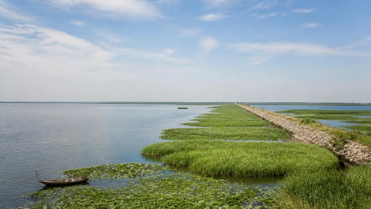
Here is the turn. That entire history — the capture, the impoundment, the raising, the breaching — produced a very large, very shallow, heavily vegetated freshwater lake in the middle of the East Asian flyway. It is now China’s fourth-largest freshwater lake, and one of the more important bird sites in the lower Yangtze basin.
The scenic area occupies 5.2 km² of the northwest shallows at Chenggou village, Linhuai town, in Sihong county — the Grand Canal to the north, the Huai to the south, the open lake to the east. It sits inside the experimental zone of the Hongze Lake Wetland National Nature Reserve, which covers some 750,000 mu, around five hundred square kilometres.
The bird list runs to 194 species. Four are nationally first-class protected: the great bustard, the oriental stork, the black stork and the red-crowned crane. Twenty-six are second-class. The reed beds hold reed parrotbill, a small endangered bird that lives in Phragmites and effectively nowhere else, and whose presence is a direct index of whether the reeds are being left alone.
In 2023 a white-tailed eagle turned up, the first record here. A reserve engineer, Li Chengzhi, gave the useful version of why that matters: it is a Jiangsu winter visitor that had gone years without being logged, and a top predator appearing means the wetland’s vertical structure — reeds, fish, mid-sized birds, raptor — is holding together rather than merely looking green.
A thousand and eight lotuses
The engineered wetland has an engineered flower collection, and it is genuinely impressive. The Thousand Lotus Garden is named for its 1,008 varieties, held across sixty mu — about a hundred thousand plants, fifteen thousand of them potted so they can be arranged, including Victoria water lilies with the leaves you can float a child on. Beyond it is a thousand-mu working lotus pond, which is a different experience: not a collection but a horizon.
The rest of the site divides into five zones and something over thirty individual attractions. The reed maze is the wetland-culture centrepiece and is what it sounds like — channels cut through standing reed, taken by boat. The deep-breath corridor runs along the reserve’s buffer zone and carries the negative-ion figures and a birdwatching tower, which is the thing to actually climb. A wetland museum built out over the water in 2006 holds six halls in 2,300 m².
And then there is the aquarium, which deserves its own note. The Hongze Lake fish hall is 5,888 m² of floor on a 20,000 m² site, ninety-nine metres long, twenty-six high, eighteen wide, and built in the shape of a Hongze Lake carp. A building shaped like a fish, containing fish, beside a lake that was built by people: at some point the site’s logic becomes self-consistent.
Three or four dates for one rating
The scenic area passed the national landscape-quality review in 2017 and was designated 5A in December 2020, third on a list of twenty-one.
Which day it happened on depends on the document. The Ministry of Culture and Tourism published the public notice on 16 December 2020; the comment period closed on 25 December; the confirming announcement is dated 29 December; and it appeared on the central government portal on 31 December. Published accounts cite all four, and none of them is wrong. It is noted here for the same reason it is noted elsewhere in these articles: the alternative is to pick one silently and state it as fact.
Reeds, crab, and the seasons
The seasonal formula the site promotes is accurate, which is not always true of seasonal formulas. Lotus from June to August. Reeds turning gold in autumn, which is also when the Hongze Lake crab is worth ordering — the lake is one of the two big Jiangsu crab names, and unlike the other one it is not usually priced as a luxury. Migratory birds in winter, in the cold, with the site nearly empty, which is when a serious birdwatcher should come.
Practicalities: peak season, March to November, is 8:00 to 17:30; off-season, December to February, 8:30 to 17:00. The sightseeing train runs about fifteen kilometres of the site with hop-on-hop-off stops for thirty yuan, and there are bicycles, tandems and electric carts. The distances are real and the ground is flat.
Visiting
Go for the birds and the reeds, in autumn or winter, and take the tower seriously. Skip nothing else on principle — the lotus garden is good, the fish-shaped aquarium is a period piece worth ten minutes — but understand that this is a developed 5A wetland with a training centre and a commercial street, engineered for throughput, not a wilderness. The wildness is at the edges, in the reed beds, where the parrotbills are.
And it is worth holding two facts at once while standing on the boardwalk.
The first is that this is one of the best wetlands in the lower Huai basin, with a hundred and ninety-four species of bird on it and a top predator that came back in 2023 after years of absence.
The second is that none of it would exist if the Yellow River had not stolen the Huai’s mouth in 1194, and if a Ming official had not decided in 1578 to keep the resulting flood and hold it above the fields, and if a Qing official had not spent the 1670s raising that wall higher — a chain of decisions that kept the empire’s grain moving for three centuries, breached a hundred and forty-one times, drowned a city of nine hundred and forty-five years in 1680, and left, as a by-product nobody was aiming for, five hundred square kilometres of habitat.
The reed parrotbills are not aware of any of this. They are the only thing here that is entirely at home.
The LoreLens app can tell you what you are looking at across the reed beds and boardwalks here, in five languages, from a photograph.
Location profile
Where it is

Frequently asked questions
Is Hongze Lake a natural lake?
No, and this is the single most interesting thing about it. Before the twelfth century there were only shallow ponds and marshes on the right bank of the Huai River. The Yellow River captured the Huai's channel in 1194 and drowned them into one sheet of water; then, from 1578, Ming and Qing engineers deliberately dammed and raised that water to use it as a reservoir for flushing silt out of the canal system. The lake sits above the level of the countryside behind its dyke. It is a piece of hydraulic infrastructure that has been running for roughly four hundred and fifty years.
When was the scenic area designated 5A?
It passed the landscape-quality review in 2017 and was designated in December 2020, third on a list of twenty-one. The exact day depends on which document you count: the Ministry of Culture and Tourism posted the public notice on 16 December, the comment period closed on 25 December, the confirming announcement is dated 29 December, and it appeared on the central government website on 31 December. Sources cite all four.
What is the best time of year?
Lotus from June to August, when the Thousand Lotus Garden and the thousand-mu lotus pond are both open. Reeds turn gold in autumn, which is also crab season. Winter is for migratory birds, including the cranes and storks, and it is cold and largely empty. Spring is the quietest and least remarkable.
Can you see the Great Dyke from the scenic area?
No. The wetland is on the northwest shallows in Sihong county, Suqian. The Hongze Lake Great Dyke — seventy kilometres of masonry, sixty thousand basalt blocks, inscribed with the Grand Canal on the World Heritage List in 2014 — is on the eastern shore, in Huai'an, roughly across the lake. So is the buried city of Sizhou. Seeing the wetland and the engineering that made it requires two separate trips to two different prefectures.
How do you get around inside?
The site is 5.2 km² and mostly water, reed bed and boardwalk. There is a sightseeing train covering about fifteen kilometres with hop-on-hop-off stops, bicycles and tandems for hire, and electric carts. Walking the whole thing is possible but the distances between the aquarium, the lotus garden and the birdwatching tower are substantial. Allow most of a day.