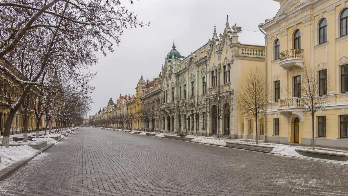
Heilongjiang · Harbin
Central Street, Harbin: A Concession You Can Walk On
The street is 21.34 metres wide because that is exactly ten Russian sazhen. It was called China Street because that is where the Chinese labourers lived. The granite was laid in 1924 by frontage owners who were billed for it. None of this is atmosphere; it is administration, and it is still underfoot.
Most guides describe Central Street as European atmosphere in an unlikely place, which is true and almost useless. It does not tell you why the street exists.
Here is a better place to start. The street is recorded at 21.34 metres wide. That is a strange number in metres and a round one in Russian units: one sazhen is 2.134 metres, so the width is exactly ten sazhen. The street was set out by people using an imperial Russian ruler, on Chinese soil, in a strip of land where a railway company held administrative, judicial and garrison rights.
That is the subject. Not exoticism — jurisdiction. And most of it is still readable from the pavement up.
A cart track named after the people who lived on it
Harbin begins as a construction site. The Chinese Eastern Railway was agreed under the Sino-Russian treaty of 1896, work started in 1897, and the whole line opened on 14 July 1903, running from Chita through Manchuria to Vladivostok with a branch south to Dalian.
Materials came upriver. Boilers, rails and locomotives were landed on the Songhua bank, and the carts hauling them inland cut a track through reed marsh and old river channel. That track is the street.
The name follows from who was housed on it. Chinese municipal accounts state, with unusual consistency, that the railway’s engineering bureau allotted this riverside waste ground to the Chinese labourers who had come north from Shandong, Hebei and beyond, and that by around 1900 the road through it was China Street — Kitaiskaya Ulitsa in Russian — meaning the street where the Chinese lived.
Two cautions on that. The Russian name is solidly attested; it appears on Russian maps of the city. The explanation, though, is repeated in identical wording across municipal histories, tourism pages and encyclopaedias without any of them citing a founding document. It is a well-established local account, not an archival finding, and worth stating that way.
What is not in doubt is what happened next. From about 1902 foreign merchants began buying and leasing the frontages, and within a few years the street where the Chinese lived was a commercial street with Russian signboards.
What a railway concession actually was
This section is the one that makes the rest legible, so it is worth two minutes.
The railway company did not merely own track. Along its line it held rights of civil administration, justice and garrison — an arrangement contemporaries described as larger and looser than a treaty-port concession. A civil administration department was set up on 2 April 1907, covering Harbin, Manchuria Station, Hailar and Suifenhe. A Harbin municipal self-government council first met on 11 March 1908 and progressively took over commerce, works, utilities, parks and schools.
Other powers signed on rather than object: an Anglo-Russian agreement of 1914 recognised the Russian position in Harbin in exchange for equal treatment of British residents, and the United States, Japan and Italy followed.
The geography of the arrangement is still in the district names. Daoli, “inside the line”, is west of the railway and was known in Russian as Pristan, the wharf district; Daowai, “outside the line”, is east. A Harbin Daily feature quotes the practical effect in one sentence: motor cars did not go into Daowai, and Chinese rickshaws did not come into Daoli. Passengers changed vehicles at the boundary.
Central Street is the spine of Daoli. It was never a general shopping street for the whole city.
Measure the street before you look at the buildings
Three numbers, and one of them is the argument.
Length is generally given as 1,450 metres, from Jingwei Street in the south to the flood monument square on the river in the north; a 2024 newspaper feature says “over 1,400”. Chinese Wikipedia extends the southern end to Xinyang Square, which is a wider definition of the same street — the pedestrian section is the shorter one.
Width is 21.34 metres, of which the stone carriageway is 10.8 metres. And 21.34 is ten sazhen exactly, to the centimetre. The metric figure that gets printed everywhere is a conversion of a Russian dimension.
Building count is usually given as 71 European or European-style structures. As with any such row, that number depends on where you draw the line — the same problem we describe in our Bund guide, where three different totals are all defensible.
May 1924: who paid for the bread stones
The paving is the street’s signature and its date is often misstated, so fix it: May 1924, not the late 1920s. Harbin marked the centenary in 2024.
The organising body was the municipal self-government council, and a Harbin Daily feature, citing a local architectural guide, gives the funding mechanism plainly: the council raised 98,000 yuan from the owners of the frontages. The people who benefited from the surface were billed for the surface. That is a municipal-finance fact, and it is more informative than any amount of writing about cobblestone charm.
The blocks are granite, cut at about 18 by 10 centimetres, rounded on top, and they are called bread stones because that is roughly the size and shape of a Russian bread roll. The design and site supervision are credited to a Russian engineer whose name is transcribed in Chinese as Komtra Shoke.
Two claims travel with the stones, and both need labels.
The count. You will see about 870,000 everywhere. It is arithmetic: 1,450 metres of a 10.8-metre carriageway is 15,660 square metres, and a block of 18 by 10 centimetres covers 0.018 square metres, which divides to exactly 870,000 with nothing allowed for joints. Notice also that the sources quoting the figure usually describe the street as “a good kilometre long”, which would not produce it. Treat it as an estimate that has hardened into a fact.
The price. Every version of the one-stone-one-silver-dollar line is prefaced by it is said. No ledger has surfaced.
There is now a third layer. In 2024 a commercially restored courtyard at number 50 was publicised as the birthplace of the first bread stone, complete with an origin story in which the engineer copied the shape from a baker friend’s loaf. The courtyard and its five square metres of old squared setts are real; the naming anecdote arrives attached to a visitor attraction, and should be read accordingly.
The rename, and why the date is contested
Under the Cultural Revolution the street was briefly called Fangxiu Street, “guard against revisionism” — a renaming that at least tells you what it was reacting to. The earlier rename, from China Street to Central Street, is the one sources cannot agree on.
Heilongjiang’s provincial culture and tourism department, and a great deal of tourist writing, give 1925. Chinese Wikipedia’s street infobox and the 2024 Harbin Daily feature give July 1928, in both cases tying it to the recovery of Chinese control over the city.
The administrative record does not settle it, but it is worth laying beside the two dates. Russian subjects lost extraterritorial rights in China in 1920. The Russian-run municipal self-government council was dissolved by the Chinese special-district administration on 30 March 1926 and replaced by a provisional committee. The Special City of Harbin was constituted on 1 September 1926. A rename framed as an assertion of Chinese authority sits more naturally after that sequence than before it — but no source we could open states which year is right, so both remain in circulation.
Six addresses and what each was for
Numbers, not names, are the reliable handle here; tenants changed constantly and street numbers did not.
Number 89, the Hôtel Moderne. Built for Joseph Kaspé, a Russian Jewish businessman who reached Harbin in 1907 and also owned most of the city’s cinemas and theatres. Sources date it from about 1906 to completion in 1913, and describe the style variously as Art Nouveau or as French Renaissance in a Louis XIV manner — the disagreement is real and both readings have support in the facade. It is still a hotel. It was listed nationally in 2013 as part of the group of Harbin Jewish sites.
Number 120, the former Matsuura trading house. The street’s Baroque set piece, built for a Japanese firm. The dates conflict outright: Chinese Wikipedia says begun February 1909 and calls it one of the earliest buildings on the street; the Harbin Daily feature says begun 1916, completed 1918. After 1945 it housed the Soviet émigré association, then Xinhua Bookstore’s provincial branch, then from 1981 an education bookshop; recent accounts differ on whether that bookshop or a restaurant occupies it now.
Number 73, the Okun Building. Built 1917 in a Renaissance manner for the Jewish merchant Okun as a store, used as a bank under Manchukuo, later a women’s and children’s goods store. Municipal Class II protection in 1997, national listing in 2013.
Number 107 and the Daoli Churin. A Harbin Daily feature dates the Samsonovich brothers’ trading company here to 1911 and its use by Churin from 1916; Chinese Wikipedia dates the Daoli Churin building to November 1919. Churin itself is the older thread: founded by Ivan Churin at Nikolayevsk-on-Amur in 1867, Harbin branch opened 14 May 1900, taken over by HSBC in 1937, by Japanese owners in 1941, by the Soviet government in 1945, and transferred to Chinese state ownership in October 1953.
Number 58, the former Miniature tea shop. Built 1926, later a Victoria tea shop, a restaurant, a clothing store, a photographic studio. The building on the site now differs substantially from the original, whose capitals carried female heads.
Number 112, Huamei. The lineage is a confectioner’s, then the Mars tea shop from 1926, a restaurant from 1931, a renaming in 1948, and the arrival of the Huamei name in the 1950s after a merger. The building you photograph dates from 1992.
One more, because its tenant list is the whole political history in a single address: number 32, the Michkov Building, put up by a Russian émigré, rented to the Harbin Special City self-government committee, used as the municipal office under Japanese rule, then as Harbin’s city government after 1949, and latterly as a hotel.
The side streets are a census
Walk one block off Central Street and the old names do work that the facades cannot.
West First Street was Prison Street, because Harbin’s prison stood there. Hongzhuan Street was Bread Street until 1925, from a Greek-run bakery opened on it in 1902. West Tenth was Russian Street, where many Russians first settled. West Ninth was Insurance Street, after a Moscow fire insurance company’s office. West Seventh was Mongol Street, from the office a Jasagtu banner prince opened in Harbin in 1902, which closed after 1912. West Sixth was Japanese Street, from a Japanese temple. West Fifteenth was School Street, after a girls’ school on it.
And Shangshi Street, now Hongxia Street, is where the writer Xiao Hong lived with Xiao Jun for close to two years, at number 25. Her essay collection of the same name is the most useful corrective to the postcard: she describes the south end of Central Street after dark, where the crowd thins and people are sleeping in the corners and against the walls, in earshot of the lit part.
The Jewish street
Harbin held one of the largest Jewish communities in the Far East, and its buildings are two minutes’ walk from the granite.
The first arrivals came as railway technical staff with the Russians; more came after 1917. A Jewish community association was formed in 1903, a religious body in 1908, and by around 1920 the community numbered above 20,000. The old synagogue on Tongjiang Street was begun 3 May 1907 and finished 15 January 1909, burned in June 1931 and was rebuilt; it closed in 1963, and after a municipal restoration reopened in 2014 as a concert hall. The new synagogue on Jingwei Street, built by the Hasidic congregation, was begun 21 September 1918 and completed 25 September 1921 to a design by the Jewish architect Joseph Levitin, with room for 500 worshippers and described as the largest synagogue in China; it closed in 1956 and since 2004 has housed a museum of Harbin Jewish history. Fourteen Harbin Jewish sites were listed nationally in 2013.
The community’s decline has a date and a case. The Russian Fascist Party was founded in Harbin on 26 May 1931 under Konstantin Rodzaevsky. In August 1933 Simon Kaspé, Joseph Kaspé’s son, a pianist home from the Paris Conservatoire, was kidnapped; a ransom of 100,000 dollars was demanded, half an ear was delivered, and his body was found on 3 December 1933. The kidnappers were convicted, then released after Rodzaevsky argued their motive was patriotic. By the mid-1930s Harbin’s Jewish population had roughly halved, and most of the rest left over the following two decades.
The hotel at number 89 and that case belong to the same family. It is worth knowing while you stand in front of it.
1997: the street becomes a product
The modern street is a deliberate creation and its paperwork is public.
Harbin designated Central Street a protected building street in 1986. Reconstruction works began in August 1996, and the pedestrian street opened on 1 June 1997. The city describes it as mainland China’s first commercial pedestrian street; that is the city’s claim, though the chronology is not implausible, since Nanjing Road East in Shanghai was pedestrianised in 1999.
In 2009 Central Street was named in the first batch of China Historic and Cultural Streets, alongside Badaguan in Qingdao and Pingjiang Road in Suzhou. Read that title precisely: it is a selection-and-promotion programme run by two newspapers with the approval of the culture ministry and the state heritage administration, not a statutory protection category of its own. The street is separately rated 4A.
The superlatives on the signage — Asia’s longest pedestrian street, Asia’s first street — are promotional, and the visitor-number figures in tourism copy are self-reported. The verifiable claims are the dull ones: 1,450 metres, ten sazhen wide, 71 buildings by the usual count, first batch of 2009.
The other end of the street is a flood wall
Walk north and the granite ends at the Flood Control Monument, and the monument is the honest full stop.
In 1957 the Songhua threatened the city and was held by improvised embankments. The monument went up in 1958 on the river dyke, with the dedication ceremony on 6 September 1960; the mayor personally decided that it should face down Central Street. It stands 22.5 metres high, ringed by a colonnade of twenty Corinthian columns.
The part to look at is at your feet. The pool below the monument is marked with flood levels: 119.72 metres for the 1932 inundation, 120.30 metres for 1957, and a gilt tube on the shaft at 120.89 metres for the flood of 1998.
So the street runs from a marsh where labourers were housed, through a mile of frontages financed by their owners and set out in Russian units, and ends against a dyke marked with the three occasions the river came over it. The buildings are the least interesting thing about it — and if you want one more building where the whole sequence is legible in a single object, it is Saint Sophia, a short walk east.
The LoreLens app can identify individual Central Street buildings from a photograph and explain their construction dates, original owners and current uses on the spot.
Location profile
Where it is

Frequently asked questions
Why was it called China Street, and when did the name change?
The original Russian name was Kitaiskaya Ulitsa, China Street, and it is attested on Russian maps of Harbin. Chinese municipal accounts explain it consistently: the Chinese Eastern Railway's engineering bureau allotted the low-lying riverside ground to the Chinese labourers who had come north for the railway works, and by about 1900 the cart track through it was the street where the Chinese lived. That explanation is near-universal in local sources and none of them cites a founding document for it, so treat it as a well-established municipal account rather than an archival finding. The rename to Central Street is where sources genuinely split. Heilongjiang's provincial culture and tourism department and much tourist material give 1925; Chinese Wikipedia's street infobox and a 2024 Harbin Daily feature give July 1928. The administrative sequence is worth knowing when you weigh them: Russian subjects lost extraterritorial rights in 1920, the Russian-run municipal self-government council was dissolved on 30 March 1926, and the Special City of Harbin was constituted on 1 September 1926. Nothing we could check states outright which renaming date is correct.
Are the paving stones original, and how many are there?
The paving campaign is dated to May 1924, and Harbin marked its centenary in 2024, so the date is solid even where other details are not. The blocks are granite, generally given as 18 centimetres long by 10 wide, cut to roughly the size of a Russian bread roll, which is where the local name comes from. The commonly quoted total is about 870,000 stones. That number is arithmetic, not a survey: tile 1,450 metres of the 10.8-metre stone carriageway with 18-by-10-centimetre blocks, allow nothing for joints, and you get exactly 870,000. The much-repeated line that each stone cost one silver dollar is always introduced with the words it is said, and no source we found puts a ledger behind it. The surface is also a maintenance object, relaid and patched in sections over the decades, so what you walk on is a mixture of ages.
Which buildings can you actually go into?
The hotel at number 89 is still a hotel and its ground floor is a commercial space; several of the restaurants and shops on the street occupy protected buildings and are open in the ordinary way; the two synagogue buildings a short walk west, on Tongjiang Street and Jingwei Street, are now a concert hall and a museum of Harbin Jewish history respectively and have their own admission rules. Beyond that, do not trust any list, including this one. The building at number 120 is described in one standard reference as an education bookshop and in a 2024 newspaper feature as a Western restaurant, which tells you how fast tenancies turn over here. Read the door, not the guidebook.
How much time does the street need, and how does it fit with Saint Sophia?
The walkable pedestrian section runs roughly from Jingwei Street to the flood monument square on the Songhua River, about 1,450 metres, which is twenty minutes at pace and two hours if you are reading facades. Saint Sophia is a short walk east of the middle of the street and works well as a break in the middle rather than a separate trip. Winter is the season most visitors come for and also the one that changes the street most: ice sculpture along the carriageway, heavy evening crowds, and surfaces that are genuinely slippery, because polished granite plus packed snow is exactly what it sounds like. Opening hours for individual buildings, seasonal events and any road-surface works change constantly, so check the day's notices.
Sources and further reading
Background references for the history and place names in this guide. Opening hours, ticketing and access change often — always confirm with official local information before travelling.