Heilongjiang · Harbin
Harbin Sun Island: A River Park Between Wetland and Snow
Read Harbin from a floodplain island: follow summer shade and railway-era traces to the Songhua River, or see winter snow art without confusing it with Ice and Snow World.
5A View location, maps and nearby scenic areasWalk to an authorised river edge on Sun Island and turn south. Harbin is suddenly both close and separate: towers, embankments and traffic occupy one bank, while willow shade, shallow water and soft floodplain ground hold the other. The Songhua River is not a gap between the park and the city. It is the reason the island became one of Harbin’s great shared spaces.
That relationship is the best starting point for this destination. In summer, water, woods and lawns offer a cooler rhythm within the city. In winter, the same open ground becomes a construction site for temporary snow art. Historic villas and leisure traditions add another layer, but they belong to Harbin’s complicated railway-era transformation, not to a timeless European fairy tale.
Decide which Sun Island you are visiting before you travel: a slow summer park, a winter snow-sculpture exhibition, or one part of a larger Harbin ice-and-snow day. The route, ticket, temperature, crossing and even usable entrance can be different.
Begin with the river, not the entrance stone
The well-known Sun Stone near the visitor arrival area is an easy meeting point, but it does not explain the landscape. The river does. Official city material describes Sun Island as a river floodplain wetland shaped by channels, bays, ponds and low ground along the north bank of the Songhua. This is not an upland garden placed beside water; it is a managed park laid over terrain made by water.
Look for small changes in height. A path may rise slightly above a damp hollow, a pond may connect visually with a narrow channel, and reeds may occupy ground that would not suit a formal lawn. These transitions show how a floodplain holds water, sediment and vegetation in different ways. Shore protection, drainage, bridges and planted gardens then reveal the work needed to keep a heavily visited urban park usable.
Official descriptions use two different scales: a planned scenic area of about 38 square kilometres and, when an outer protection zone is included, a total of about 88 square kilometres. Those figures do not mean visitors can or should walk an 88-square-kilometre attraction. They describe planning and protection boundaries. The main park circuit is only one part of a wider island-and-wetland system.
This distinction prevents a common mistake. Sun Island is both a nationally rated scenic destination and everyday city space. Harbin residents come for shade, walking, family outings, seasonal events and the feeling of crossing out of the dense south bank. A festival barrier or paid exhibition may temporarily divide that shared space, while another area remains a public park. Confirm the current boundary instead of assuming that “free park,” “5A attraction” and “Snow Expo” are interchangeable terms.
At the shoreline, stay behind flood or erosion barriers. Water levels, currents and bank stability change, and shallow-looking margins can drop suddenly. Do not enter reed beds for a photograph, feed waterbirds or leave food waste. The wetland is infrastructure and habitat as well as scenery.
A river island changes more than a sealed park
Sun Island’s seasons are not four decorative colour schemes. They alter access and the physical surface. Spring thaw can soften paths and raise water; summer vegetation closes views and brings insects; autumn exposes longer sight lines; winter freezes ponds, covers edges and allows snow construction. A route that worked in July may not exist in January, and a winter gate may lead into a ticketed exhibition rather than the normal park circuit.
The official scenic introduction emphasises floodplain wetland, river bays and lake-like waters. Read these features as connected processes, even when park design gives each pond a separate name. The main Songhua channel, secondary water, groundwater, rainfall and drainage all contribute to what you see. A manicured bank does not make the system static.
In summer, stay on boardwalks and surfaced paths where wet ground or habitat restoration is marked. Mosquitoes can be persistent near still water and shaded vegetation, so use repellent, cover arms and legs around dusk, and keep doors or screens closed during indoor breaks. After heavy rain, staff may close low paths; a barrier is evidence of current conditions, not an invitation to find a drier shortcut through vegetation.
Winter produces the opposite visual illusion. Snow smooths steps, curbs, pond edges and maintenance trenches into one white plane. Treat every unmarked surface as unknown. A frozen pond or river can contain moving water, thin ice near structures and snow-covered openings. Use only prepared pedestrian areas and explicitly authorised ice activities.
The island also changes through events. Concerts, markets, races, exhibitions and maintenance can redirect paths or increase security checks. Check the scenic area’s current notice, not only a static map. If quiet wetland observation is your priority, arrive early and move away from event stages; if a festival is your purpose, accept that the ordinary park experience will be altered.
Build a summer route from park to history to river
A strong summer visit has three movements. Start with the interior park while the light is soft: follow shaded paths past ponds, wetland margins and open lawns. Do not race among named attractions. Compare a formal flower bed with a reed edge, or a clipped bank with a damp hollow, and the tension between civic park and living floodplain becomes visible.
Next, turn to historical and architectural clues. Older villa-style buildings and street alignments are scattered rather than arranged as one museum row. Some structures are protected, some have been adapted for new uses, and others may be viewed only from outside. Read the date and conservation sign where one exists; do not assume every picturesque timber detail is original or every “Russian-style” building survives from the same decade.
Finish at an opened river-facing viewpoint. Across the Songhua, the south-bank skyline restores the island’s urban scale. Include an embankment, boat or bridge in the view and the park stops looking like countryside. Late light can silhouette city buildings while retaining texture in willow trunks and water, but do not climb a bank or leave an opened path for an unobstructed horizon.
Allow half a day for this sequence rather than filling it with every side attraction. Animal venues, indoor displays, entertainment projects and hired vehicles can have separate tickets and hours. Choose them deliberately. A child-friendly stop may improve a family visit, but it should not erase the wetland and river that make the destination specific to Harbin.
For a camera, carry one wide view for water and skyline, then look for smaller evidence: flood marks, reed reflections, old joinery, reused rooms and residents resting under trees. Midday light is harsh on open water, so use woods and architecture then; return to the river when the sun is lower. Drones and commercial shoots require current permission, and nesting birds need more distance than a normal phone photograph suggests.
Read the villas as evidence, not a costume set
Sun Island’s resort history grew with modern Harbin. From the late nineteenth and early twentieth centuries, the Chinese Eastern Railway transformed transport, settlement and commerce across the region. Russian and other expatriate communities were part of the new multinational city, and the island’s beaches, summer houses, gardens and recreation developed within that river-oriented urban life.
The attractive shorthand is “European summer resort,” but it leaves too much out. The railway was also an instrument of Russian imperial expansion on Chinese territory, built within unequal power relations and contested sovereignty. Harbin’s international population produced real cultural exchange, yet that exchange did not occur on politically neutral ground. Chinese labourers, traders, residents and river users were essential to the city and island even when nostalgic architectural stories push them out of frame.
The surviving architecture is not one frozen early-century ensemble. Buildings date from different phases, and restoration or reuse can add later materials. A local-government account, for example, identifies the protected Badova Villa on Linjiang Street as a 1940 building now adapted as a café. That single date is a useful warning against labelling every villa “built when the railway arrived.” Check the evidence building by building.
Notice practical design before decorative style: orientation toward light, smaller openings on colder sides, entrance lobbies that limit winter air, deep roofs, timber-and-brick construction and gardens set back from the river. These choices respond to Harbin’s climate and seasonal leisure. An onion-shaped finial or carved trim may be memorable, but it does not tell the whole social history.
Enter only where public access is offered, ask before photographing interiors, and never lean on old railings or climb foundations. Adaptive reuse can fund care and give a building a contemporary life, but a café setting should not turn complex heritage into generic “foreign romance.” The most responsible visit leaves room for beauty, evidence and unequal history at the same time.
The Snow Sculpture Art Expo is designed to disappear
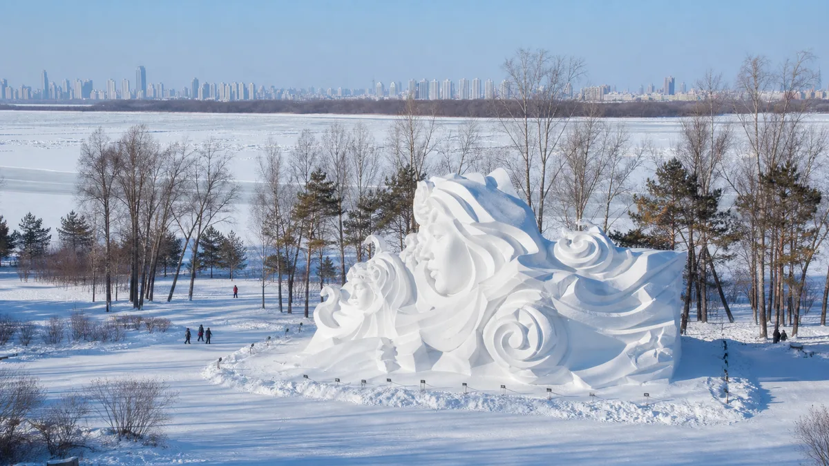
Each winter, part of Sun Island becomes the Harbin Sun Island International Snow Sculpture Art Expo, commonly shortened to the Snow Expo. Artists and construction teams compact, carve and assemble snow into large works, competition pieces and themed scenes. The exhibition is rebuilt, redesigned and eventually lost to warming weather; impermanence is not a defect but the material condition of the art.
Do not use a previous year’s map as a checklist. Themes, gates, sculpture locations, competition works, warm rooms, food points and interactive areas change. Some pieces are complete at opening while others may still be worked on or added later. Wind can soften edges, fresh snowfall can cover detail, and rising temperature can force barriers, repair or early closure. Official notices have ended editions as conditions warmed.
Read a snow sculpture from three distances. First take in mass and silhouette; compacted snow can make a figure or architectural form feel monumental. Then move sideways along the authorised path to see how relief and negative space create depth. Finally, look close enough to notice tool marks and the difference between a sharp competition surface and weathered snow—without touching it or crossing a cordon.
Photography works best when low side-light gives white surfaces shadow. Snow often causes cameras to underexpose, so check the histogram or use modest positive exposure compensation rather than turning the sculpture grey. Keep spare batteries in an inner pocket; cold reduces capacity quickly. A phone brought from severe cold into a warm room can collect condensation, so leave it in a closed bag while it warms gradually.
Dress for time standing still, not only for the walk from the metro. Near the river, wind can make an already sub-zero day feel harsher. Use an insulating base and mid-layer, a windproof outer layer, insulated waterproof boots, warm head coverage and gloves that do not require bare fingers for every photograph. Schedule indoor warm-up breaks before numbness, shivering or loss of coordination becomes a problem.
Snow Expo and Ice and Snow World are separate experiences
The Snow Expo is often confused with Harbin Ice and Snow World, but they are not two names for one gate. The Snow Expo occupies seasonal grounds within Sun Island Scenic Area and centres on sculpted snow, usually read through form, shadow and daylight. Ice and Snow World is a separate managed attraction with its own entrance, ticket and operating notice, best known for illuminated ice architecture, entertainment and large-scale night spectacle.
Material changes the experience. Snow is opaque and absorbs light, rewarding close attention to surface and silhouette. Clear or coloured ice transmits and reflects artificial light, so Ice and Snow World becomes more dramatic after dark. One is not a smaller version of the other. Visiting both means buying and navigating two products.
A possible winter day places the Snow Expo in daylight, takes a proper meal and warm indoor break, then continues to Ice and Snow World for evening illumination. It is also a demanding plan: outdoor hours accumulate, temperatures fall after sunset, batteries drain and exit crowds concentrate around transport. Travellers with children, older adults or cold-sensitive conditions may enjoy more by choosing one major outdoor venue per day.
Never assume a combined ticket, internal shuttle or continuous walking connection. A temporary holiday shuttle in one season does not establish a permanent service. Confirm each gate, reservation, identity-document rule, last entry and return transport separately. Search the full attraction name in the official channel so that a similarly named package or unofficial ticket does not send you to the wrong entrance.
Both venues are weather-dependent. Construction dates, soft opening, full opening and closing can differ, and one may close before the other as temperatures rise. A winter trip should have a non-ice alternative rather than treating one advertised date as a guarantee.
Choose the crossing before you choose the route
Harbin Metro Line 2 is generally the most predictable way to reach Sun Island. It avoids road congestion and does not depend on an open river. Check the current station exit and the entrance used by the park or Snow Expo; a large event can redirect pedestrian flow, and the nearest-looking gate on an old map may not be accepting visitors.
In navigation season, passenger ferries can link south-bank piers with Sun Island and turn transport into part of the visit. Official city reports describe both cross-river ferry and sightseeing services, including the familiar Flood Control Memorial Tower–Sun Island connection. Routes begin only after water transport opens and can stop for wind, high water, fog or operational reasons. Confirm the actual pier, destination and last return before boarding.
The sightseeing cableway offers another elevated crossing, but it is independently operated and also subject to wind, maintenance and scheduled hours. It may not accept every wheelchair, stroller or large item in the same way as the metro. Ask about step-free access and boarding assistance before relying on it as the only route back.
Buses, taxis and occasional event shuttles add options, but special holiday services are temporary. Private-car parking can fill early. A resilient plan is asymmetric: arrive by ferry or cableway if conditions allow, then return by metro. Keep the metro station saved offline so a cancelled crossing does not become a crisis.
When the Songhua freezes, informal tracks may appear on the surface. They are not proof of safety. River currents, discharge, bridges and temperature variation create uneven ice. Walk on the river only where authorities have opened, marked and are actively managing a route or activity that day; otherwise use a bridge or metro.
Let season and mobility set the pace
“Mostly flat” does not mean effortless. Sun Island covers a large area, and distance among entrances, ponds, heritage buildings, viewpoints and seasonal exhibition zones adds up. In summer, heat, humidity and insects slow the walk. In winter, packed snow, ice ridges, heavy clothing and repeated warming stops can double the time a map suggests.
Visitors who need step-free access should ask for a precise chain: correct entrance, usable surface, accessible toilet, open bridge or boardwalk, and transport back. Park vehicles or shuttles may be seasonal, event-specific or full. A ramp can still end at deep snow, a muddy path or a ferry boarding gap. Wheelchair and stroller users should confirm the day’s maintained circuit rather than relying on a general accessibility icon.
In summer, carry drinking water, sun protection and insect repellent. Avoid long grass outside paths, do not touch or feed animals, and move indoors during thunderstorms. High water or storm damage can close shore and wetland sections. In autumn and spring, thin morning ice and freeze–thaw mud deserve the same caution as deep winter snow.
In winter, build the itinerary around warm shelters, toilets and a reliable exit. Eat before a long outdoor circuit and keep medication where it will not freeze. Children may not report cold stress clearly; check fingers, toes and face. If anyone becomes unusually clumsy, confused or persistently numb, leave the outdoor route and seek warmth and help rather than trying to finish the sculpture list.
Operating hours, admission, reservations and identity checks vary between the ordinary scenic area, seasonal exhibitions and separate attractions. Use the Sun Island scenic area’s current official notice for the park and Snow Expo, and the Ice and Snow World channel for that venue. The date on a travel blog matters less than the date on the operating notice.
Leave with the city and island in one frame
Return to the river at the end. From here, Sun Island no longer looks like an escape outside Harbin. Floodplain water made the ground; the railway-era city turned it into a leisure landscape; later planning formalised park and protected zones; residents, artists and visitors continue to remake its use each season.
That long view also resists two easy myths. Sun Island is not only a Russian-style resort preserved from a glamorous past, because its modern history includes imperial power, Chinese work and changing public ownership. Nor is it only a winter snow venue, because the snow sculptures disappear while wetland processes and civic life continue.
Tourism brings conservation funding, jobs and attention, but it also compacts soil, disturbs habitat, crowds historic buildings and creates pressure for ever-larger temporary spectacles. Stay on durable paths, respect closures, reduce disposable waste and let a building or bird remain at a distance. Shared urban nature survives through ordinary restraint.
The most revealing Sun Island photograph holds two things at once: reed or snow in the foreground, Harbin across moving or frozen water. One frame then contains ecology and infrastructure, memory and public life, separation and connection—the real character of an island inside a city.
For a much larger reed wetland and careful crane-watching ethics, continue to Zhalong Nature Reserve. To compare landscapes built by volcanism rather than river deposition, see Wudalianchi or Jingpo Lake.
LoreLens can help you distinguish floodplain water, adapted historic buildings and temporary snow art on site, while keeping Snow Expo and Ice and Snow World on separate maps.
Location profile
Where it is

Frequently asked questions
What exactly is Harbin Sun Island?
Sun Island is a broad Songhua River floodplain landscape on Harbin's north side, combining wetlands, ponds, woods, lawns, visitor attractions and civic recreation. The scenic-area name can refer to a larger protected and managed zone than the compact park route most visitors walk, so use the current entrance map rather than assuming the whole island is one loop.
Is the Sun Island Snow Sculpture Art Expo the same as Harbin Ice and Snow World?
No. The Snow Sculpture Art Expo is a seasonal snow-art exhibition inside Sun Island Scenic Area. Harbin Ice and Snow World is a separate attraction with its own entrance, ticket, hours and transport, known especially for illuminated ice architecture and rides. Check both official notices before planning them on the same day.
Is summer or winter better for Sun Island?
Summer is better for shade, wetland edges, garden paths, historic clues and a relaxed river view. Winter transforms part of the scenic area into an annually rebuilt snow-sculpture landscape. Neither season guarantees every path, building, performance or transport service; choose according to the current opening notice and your tolerance for heat, insects or severe cold.
How should I cross the river to Sun Island?
Metro Line 2 is usually the most predictable option. Ferries and the sightseeing cableway can add a memorable river crossing, but they depend on navigation season, wind, water level, maintenance and operating notices. Do not treat the frozen Songhua River as a pedestrian bridge unless an officially marked route is explicitly open that day.