Heilongjiang · Mudanjiang
Jingpo Lake: Lava, Waterfall and a Forest Inside Craters
Read a long lake through its black basalt rim, watch Diaoshuilou Waterfall change with the river, and plan the separate journey to crater forest and Bohai-era ruins.
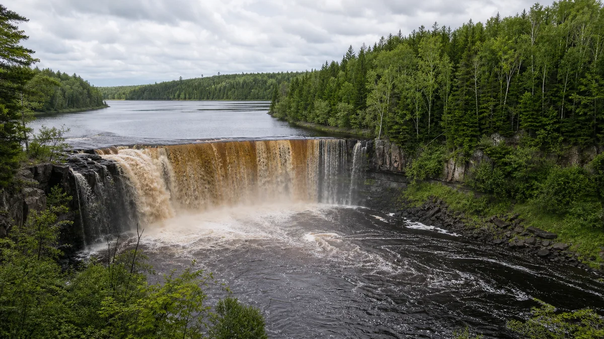
5A View location, maps and nearby scenic areasStand near Diaoshuilou Waterfall and look past the white water to the dark ledge beneath it. That black rock is not scenery placed behind the waterfall. It belongs to the basaltic landscape that interrupted the Mudan River and held a long lake behind you.
This is the useful way to read Jingpo Lake: water shows the present conditions, while basalt records the event that made those conditions possible. The famous view changes by the hour and season; the geological relationship does not.
Make one decision before setting out: are you visiting the waterfall and main lakeshore, travelling onto the lake, continuing to Crater Forest, or adding the Bohai Shangjing archaeological site? “Jingpo Lake” is used for a large scenic and geopark system, not a single compact gate.
Start with the black edge, not the postcard
At a safe, authorised viewpoint, compare three surfaces. The lake above is often visually calm. The waterfall turns that stored water into motion. The ledge and walls below are dark, jointed volcanic rock. One view therefore contains reservoir, outlet and lava barrier.
Watch the water rather than waiting for a prescribed spectacle. After rain or during high flow, it can occupy a much broader part of the rim and fill the air with spray. In lower water, separate channels and exposed basalt make the rock structure easier to read. Winter may turn part of the fall into ice, but flowing water, closed paths and unstable edges can remain.
This first stop also corrects a common misunderstanding. Jingpo Lake is not a volcanic crater filled with water. It is a lava-dammed river lake: basaltic lava obstructed the Mudan River valley, water accumulated behind the natural barrier, and the river found an outlet across and through the volcanic terrain.
Do not step beyond barriers for a cleaner angle. Wet basalt can be extremely slippery, spray can hide ice, and a quiet-looking pool below the fall is still part of a powerful river system. A photograph should preserve the relationship among rock, water and scale, not remove the safety margin that makes viewing possible.
One destination name covers three separate landscapes
The nationally designated scenic area is conventionally described in three large parts: the long-lake scenic zone, the volcanic-crater forest zone, and the Shangjing Longquanfu ruins associated with the Bohai kingdom. They share one regional story but not one car park, walking loop or operating notice.
For most first visits, the northern lake-and-waterfall area is the practical anchor. Diaoshuilou, lakeside paths, visitor facilities and departure points for whatever boat services are operating sit in this orbit. The lake itself then stretches southwest in a narrow, bending sequence of waters, bays, islands and wooded slopes.
Crater Forest—often marketed as the “Underground Forest”—is a separate road journey northwest of the principal lakeshore. An older official visitor guide places it about 52 kilometres from the main scenic area. The exact transfer used today, road conditions, shuttle stages and final walking route must be confirmed locally.
The Bohai archaeological landscape is another distinct visit near modern Bohai Town. Do not assume a lake ticket includes it or that a cruise stops there. Treat the three zones as a small regional itinerary: lake water, volcanic source terrain and a historic capital landscape.
UNESCO’s current list names the wider area Jingpohu UNESCO Global Geopark. The UNESCO spelling “Jingpohu” refers to the same 镜泊湖. A geopark designation connects geology, ecology, education and community heritage; it is not a promise that every cave, crater, dock or monument is open to unrestricted access.
Basalt blocked a river and drew a lake about 45 kilometres long
UNESCO’s current profile states that the northwestern Jingbo volcanic field erupted three times between roughly 12,000 and 5,140 years ago. It identifies four compound volcanic cones, one single cone and twelve craters. Lava from this broader volcanic history entered valleys, and basaltic flows blocked the Mudan River to create the large impounded lake.
“The volcanoes of Jingpohu have erupted at least three times in the last 12,000 years.” — UNESCO Global Geopark profile
That wording matters. Popular summaries often give Jingpo Lake one exact birthday, but the protected landscape records multiple eruptions and multiple lava units. Not every cone erupted simultaneously, and not every visible flow performed the same role in damming the river. The honest story is a sequence: eruption, lava movement and cooling, river obstruction, water accumulation, then continued erosion and human management.
The scenic-area management committee gives the lake a length of about 45 kilometres and a maximum width of about 6 kilometres. Read 45 kilometres as the approximate long axis of the bending water body, not as shoreline length, a cruise distance or a promise that all sections are navigable. The shoreline is much longer because it turns around bays and headlands.
Published surface-area and depth figures also vary. Some describe the managed main water body at a particular level; others use a different boundary, survey date or lake stage. Water level itself changes seasonally. For an on-site sense of scale, the robust facts are more useful: a narrow lake tens of kilometres long, markedly wider in some basins than others, occupying the former river corridor behind basalt.
Look across rather than only along the water. A narrow cross-lake view makes wooded slopes feel close; a long-axis view lets successive headlands overlap and reveals why the lake can appear like several separate basins. Those two compositions describe the same geometry better than a single area number.
Diaoshuilou Waterfall measures water, not a fixed spectacle
Diaoshuilou sits at the lake’s northern outlet, where water leaves the impounded basin across a basaltic rim and falls into the dark pool commonly called Heilongtan, or Black Dragon Pool. An official scenic-area introduction uses an approximate drop of 20 metres and describes a high-water curtain extending for more than 100 metres. Other published figures differ because they measure different crest sections, pool levels and flow conditions.
The operational lesson is simpler than choosing one supposedly permanent number. Width, apparent drop, channel pattern and spray all change with discharge. In low flow, exposed columns, cavities and joints reveal how the water exploits fractures in basalt. In high flow, multiple channels may merge and overflow around more of the rim. Flood water can also close the closest viewing areas precisely when the waterfall looks most dramatic.
The well-known cliff-diving performance is a human event staged in this volatile setting. It is not part of the waterfall’s natural cycle and must never be treated as guaranteed. Weather, water level, performer safety and management decisions can alter or cancel it; official notices have done so. Watch only from authorised areas and never imitate the dive.
In winter, ice can preserve the path of earlier spray as curtains, columns and frozen margins. Yet “frozen waterfall” does not mean every channel has stopped, nor does a white lake prove load-bearing ice. Stay on opened routes, keep away from overhanging ice, and follow current staff instructions about where winter viewing is permitted.
Choose water or shore before you count attractions
A satisfying shore-first route begins with the waterfall while attention and paths are fresh, continues to a legal basalt viewpoint, then slows down along one opened lakeside section. This works when cruises are cancelled, visibility is poor or you have only half a day. It also gives more time to compare water level, rock texture and forest edge.
A lake-first or mixed route adds an operating cruise from the confirmed departure pier. From the water, the essential sight is not a checklist of named rocks but the repeated narrowing and widening of the old valley. Keep one shoreline in the frame and watch headlands overlap: that is what makes a 45-kilometre lake legible. Ask before boarding about the actual route, duration, return point, enclosed or open seating, and whether any intermediate landing is included.
Boat routes, piers and last departures can change with wind, fog, water level, demand and maintenance. Never build an onward transfer around an unconfirmed last boat. If mobility, seasickness or cold wind is a concern, a shore route is not a lesser version of the visit; it can show the lava-water relationship more clearly.
On land, expect distances among gate, waterfall, pier and viewpoints to be managed by some combination of walking and site transport. The current map at the entrance outranks an old online itinerary. Ask which path is continuous and step-free today, not merely whether the scenic area is described as “accessible.” Ramps may still end at stairs, wet stone or an unsuitable boarding gap.
Keep swimming, fishing, drones and shoreline access within posted rules. Clear-looking volcanic-lake water is not proof that it is potable, sterile or therapeutic. Do not turn a geological origin into a health claim, and do not collect basalt as a souvenir from a protected landscape.
The “Underground Forest” is inside craters, not beneath the earth
The Chinese name 地下森林, literally “underground forest,” is easy to misread. It does not describe trees growing in a cave. It refers to forest established within and along deep volcanic depressions, so the canopy can lie below the observer’s rim. Crater walls, collapsed terrain, lava blocks and mature mixed forest create the sense of looking down into another level of the landscape.
UNESCO describes the volcanic field as having twelve craters and a well-preserved forest ecosystem. This is the source terrain that completes the lake story: cones and vents show where magma reached the surface; lava landforms show how it moved and cooled; the distant lake shows the hydrological consequence when flows obstructed a river.
Do not compress it into a spare hour after the waterfall. The crater zone requires a separate road transfer, and the useful trail may include long stairs, roots, loose volcanic rock and steep returns. Forest-fire controls, storm damage, ice, wildlife management, maintenance or shuttle operations can close part or all of the route. Confirm opening status before leaving the lake zone, especially if you depend on a return connection.
At the rim, look for differences rather than a perfectly circular hole. Compound cones overlap; erosion and vegetation soften outlines; some depressions are easier to recognise through changes in slope and canopy height than through bare rock. On the descent, temperature and moisture can change. Stay on the formal path: moss and leaf litter conceal cavities, and protected forest is not a place for shortcuts.
The forest is also evidence of time after eruption. Lichens, soil formation and successive plant communities transformed raw lava into habitat. Calling it “primeval” should not imply a world without people or management: rangers, researchers, fire crews and local workers now help keep the ecosystem and visitor route functioning.
Bohai Shangjing adds a human map to the volcanic one
The wider scenic and geopark story includes the ruins of Shangjing Longquanfu, associated with the Bohai kingdom of the Tang period. UNESCO identifies the site as a nationally protected cultural relic and as part of China’s National Archaeological Site Park system. It is a documented archaeological landscape, not a palace reconstruction on the lakeshore.
The surviving logic is urban. Wall lines, gates, roads, palace and temple foundations, excavated objects and interpretation reveal how a major regional centre was organised. What is visible depends on conservation and exhibition arrangements, so begin at the current interpretation facility if it is open. Foundations that look low in a photograph become meaningful only when their axes and enclosed spaces are explained.
Keep the human and geological maps connected without claiming that volcanoes determined every political choice. The Mudan River basin offered routes, water, agricultural land and connections across Northeast Asia; communities lived within a terrain already shaped by older volcanism. The archaeological site shows one historically specific use of that landscape.
Do not climb earthworks, cross excavation barriers or remove tile fragments. Ask before photographing interiors or conservation work. Opening days, ticketing, passport checks and English-language interpretation can change, and the ruins should be planned as a separate stop rather than an automatic add-on to a boat ticket.
Local stories and scenic names can enrich a visit, but they should be labelled as tradition when evidence is uncertain. The strongest regional narrative needs no invented legend: a river became a lake, forest occupied craters, and people built a capital in the same basin over a much shorter timescale.
Let season, light and safety set the camera plan
In summer, stronger flow can broaden Diaoshuilou and green forest makes the black basalt stand out. The trade-off is spray, exposed sun on open paths, insects, thunderstorms and possible flood restrictions. Carry water and rain protection, but keep both hands free on wet steps. Never approach a closed edge merely because other visitors are doing so.
In autumn, colour separates forest layers and low-angle light can model the headlands. Peak foliage and clear weather are not fixed appointments; cold snaps, wind and haze alter both. In winter, snow simplifies the long shoreline and ice textures can be striking, but exposed wind, short daylight, closed roads and slippery paths slow every transfer. Use only officially opened ice-viewing areas.
For the waterfall, a moderately fast shutter can retain texture in the falling water; a slower exposure requires a stable position that does not block the path. Frame a person or railing from a safe distance to show the scale of the basalt rim. For the lake, use overlapping headlands rather than an empty band of water. For Crater Forest, a wide view from the authorised rim explains the depression better than a close-up of trees.
Fog, sunrise reflection, a full waterfall, autumn colour, cliff diving, a cruise and an ice curtain are all conditional. Choose one primary subject that the current conditions actually provide. A geologically honest photograph of exposed basalt in low water can say more about Jingpo Lake than a heavily cropped wall of white spray.
Jingpo Lake is reached through Ning’an and the wider Mudanjiang transport network, but schedules and road times change with season and weather. Confirm the correct gate, ticket or reservation rules, accepted identity document, current shuttle and return transport through the scenic-area management committee or local tourism authority. Travellers who need step-free access should request the exact usable chain from vehicle drop-off to viewpoint and toilet.
Leave with river time and human time together
Return once more to the black ledge. At the start it may have looked like a platform under a waterfall. Now it can be read as part of a much larger system: repeated eruptions built a volcanic field, lava entered valleys, the Mudan River ponded behind basalt, water continued to cut an outlet, and forest reclaimed crater slopes.
That geological story does not make the present landscape automatic. Water level is managed and seasonal; boats and performances operate under safety limits; roads and steps determine who can reach a view; conservation rules protect unstable rock, forest and archaeological remains. Tourism supports interpretation and local work while also bringing wakes, noise, waste and pressure for closer access.
The balanced way to visit is therefore not to demand every advertised scene. Let high water hide the basalt or low water reveal it. Let a cancelled cruise become a slower shore walk. Let the crater forest and Bohai ruins remain separate journeys if time is short.
Jingpo Lake is most memorable when the mirror stops being the whole subject. Lower the camera for a moment and listen: moving water is still negotiating with cooled lava, while human routes continue to negotiate with both.
For another volcanic landscape where individual cones, lakes and mineral springs require careful route choices, continue to Wudalianchi. For a border-region history told through fortifications and river geography, see Hutou Scenic Area.
LoreLens can help you distinguish the lava barrier, changing waterfall and crater terrain on site, then place the Bohai archaeological landscape on a separate human timeline.
Location profile
Where it is

Frequently asked questions
Is Jingpo Lake a UNESCO Global Geopark?
Yes. UNESCO's current list uses the spelling Jingpohu UNESCO Global Geopark. The designation covers a broad geological and cultural landscape, not one ticketed enclosure, and it does not guarantee that every crater trail, cruise route or heritage site is open on the day you visit.
Will I see the cliff-diving show, a full waterfall and a lake cruise?
None of those three experiences is guaranteed. Diaoshuilou Waterfall remains a geological feature, but its visible width and drop change with water level. Diving performances and cruises may be adjusted or suspended for weather, flood conditions, safety, maintenance or seasonal operations. Check the management committee's latest notice and ask again at the entrance.
Can I visit the lake and the Underground Forest in one day?
It may be possible with an early start and confirmed transport, but the Crater Forest zone is not beside the main lakeshore. Official visitor material places it roughly 52 kilometres northwest of the main scenic area, and internal transfers or shuttle rules can change. Two days give each landscape a more realistic pace.
When is the best time to visit Jingpo Lake?
There is no single best season. Summer can bring a broader waterfall and cruises but also rain, spray and flood closures; autumn adds forest colour; winter can produce a frozen waterfall and a white lake but does not make the ice automatically safe. Confirm current access, weather, transport and authorised ice areas before travelling.