Heilongjiang · Hulin
Hutou: The Ussuri River and a Fortress at War's End
Begin with the Ussuri border landscape, then move through Hutou's museum and underground works to understand forced labour, the August 1945 battle and why 'the last battle' needs context.
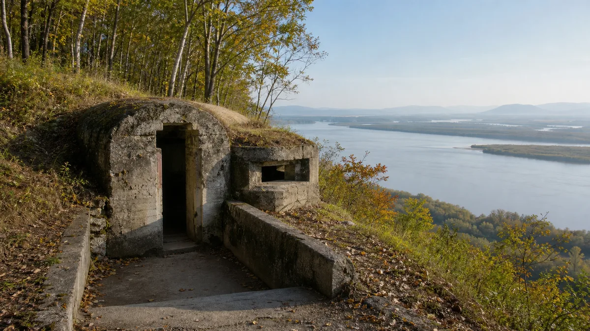
5A View location, maps and nearby scenic areasStand where you can see the Ussuri River and trace the opposite bank with your eyes. The water looks open and calm, but here it is also an international boundary. Now turn away from the view and look at the low concrete opening pressed into the wooded hill. That reversal—from river horizon to buried corridor—is the key to Hutou.
This is not a ruin to approach as a catalogue of giant weapons. It is a landscape where geography became military calculation, where a secret fortress was built through coercive labour, and where fighting continued after millions of people had heard that Japan would surrender. The most useful visit keeps all three layers together.
Use a four-part route: read the river first, build the chronology in the museum, enter only the officially open underground section, then return to daylight and reconsider the same horizon.
Begin with the river that made Hutou strategic
The Ussuri flows north along part of the China–Russia border before joining the Heilongjiang, or Amur. Around Hutou, its broad channel, islands and floodplain create a view that seems larger than the town. The opposite bank is close enough to make the border visible as geography rather than an abstract line on a map.
That view explains why the hill behind you mattered in the 1930s. From high ground on this side, forces could observe movement across the river and towards the railway network beyond it. Japan’s Kwantung Army—the military force that controlled the Japanese puppet state of Manchukuo after the occupation of Northeast China—developed Hutou as one of a chain of fortified border positions facing the Soviet Union.
Do not point a long lens indiscriminately across the boundary. Use the river to understand distance, channels and floodplain, but follow every photography sign and barrier. A scenic viewpoint does not cancel border rules, and a drone that is legal in an ordinary park may be prohibited here.
A hidden system built into several hills
Major construction began in 1934 and continued through the late 1930s, with reinforcement and changes later. “Hutou Fortress” was not one bunker. It was a dispersed system of observation points, gun positions, command spaces, stores, power and ventilation facilities connected through excavated and reinforced underground works across several hills.
The surviving concrete is only part of that system. Collapse, battle damage, post-war removal and decades of weather mean that a visible doorway should not be treated as a complete floor plan. Claims about total tunnel length, maximum depth and troop capacity also vary because sources count different positions and phases. The honest scale is already sufficient: this was an extensive military landscape, not a single room under a hill.
The construction story is inseparable from Chinese labourers and prisoners who were compelled to work under harsh and secretive conditions. Published estimates of the workforce and deaths differ sharply, and local accounts of workers killed to protect secrecy are not documented in the same way in every source. Do not turn that uncertainty into silence. Numbers may be disputed; coercion, dangerous conditions and human suffering belong at the centre of the site.
Read the concrete as control, not technological spectacle
Inside an authorised passage, pause before looking for a weapon label. Notice instead how the structure controls bodies and information. A bend blocks a direct line of fire. A narrow doorway separates compartments. Thick concrete, earth cover and small embrasures trade daylight and comfort for protection. Ventilation, drainage and power were as necessary as artillery.
This is where scale becomes physical. Cool air gathers below ground even in warm weather. Water marks show that the hill continues to act on the building. Echoes shorten your sense of distance, and one flight of stairs can separate the bright river landscape from almost total darkness.
Museums sometimes foreground the fortress’s unusually heavy guns. They help explain the strategic reach intended for the position, but hardware should remain evidence rather than entertainment. Ask what resources, transport and labour were consumed to place it here—and who paid the cost without choosing the project.
August 1945: build the timeline before entering the battle story
The Soviet Union declared war on Japan on 8 August 1945, and Soviet forces began their major offensive in Northeast Asia in the early hours of 9 August. Fighting at Hutou started as troops crossed and attacked the fortified area. The wider Kwantung Army was already weakened because experienced units and equipment had been transferred to other fronts, but Hutou still contained a garrison, heavy positions and civilians who sought shelter amid the fighting.
On 15 August, Emperor Hirohito’s surrender broadcast told listeners that the war had developed “not necessarily to Japan’s advantage” and announced acceptance of the Allied terms. He was Japan’s wartime sovereign, and the broadcast was the first time most subjects had heard his voice. Its formal language, poor reception and the breakdown of command meant that hearing it was not the same as receiving a clear, trusted order.
Accounts describe attempts to communicate the surrender to Hutou after the broadcast, but details differ. What is clear is that organised resistance continued. Soviet forces reduced positions one by one; the main fortress is commonly recorded as falling on 26 August, while some accounts trace small groups beyond that date. Soldiers and civilians died underground as the position was destroyed.
Why “the last battle” needs a careful label
Hutou is often called the place where the Second World War’s last battle was fought. The phrase captures something real: substantial combat here continued after 15 August, when many communities already understood the war to be ending. It also gives local remembrance a memorable frame.
But “last” depends on the calendar and boundary you choose. Combat and surrender unfolded at different speeds across Northeast Asia and the Pacific. Japan signed the formal Instrument of Surrender on 2 September 1945. Other isolated encounters and disarmament operations also occurred around the transition. Hutou should therefore be understood as one of the war’s last fierce battles, not a record that settles every global chronology.
That distinction makes the story stronger, not weaker. It shifts attention from a slogan to a harder question: how can violence continue after a political decision has supposedly ended it? Broken communications, disbelief, military culture, fear and physical isolation all meet in these tunnels.
Keep workers, soldiers and civilians in the same history
Fortress narratives easily narrow to commanders, guns and maps. Hutou requires a wider cast. Chinese labourers built under coercion. Local residents lived beside a militarised border. Japanese soldiers defended the system, while Japanese civilians also took refuge within it in August 1945. Soviet soldiers attacked from across the river and died taking the positions.
These groups did not hold equal power or responsibility, and they should not be collapsed into a vague statement that “everyone suffered.” Imperial occupation created the fortress and the forced-labour system. At the same time, recognising civilian deaths and individual fear does not excuse that structure. A mature memorial visit can hold both facts at once.
Look for names, personal objects, labour evidence and excavation records in the displays. They interrupt the architectural scale with individual lives. If the museum presents different casualty figures from another source you have read, note what each number counts—combatants, civilians, a single position or the entire complex—before assuming one is simply false.
Move from landscape to evidence and back again
Start at the river viewpoint. Identify the current, islands and opposite bank. This gives the fortress’s line of sight a real scale.
Continue through the museum or interpretation displays. Build the sequence from occupation and construction to the Soviet offensive and post-war preservation. Read labels before entering the tunnels; underground, it is much harder to understand which period or function a room represents.
Enter only the open preserved section. Wear shoes with grip, keep a warm layer available and let faster groups pass at wider points. Do not touch unstable surfaces, enter sealed branches or treat memorial spaces as dramatic portrait sets.
Finish above ground. A river or memorial stop after the tunnels prevents the visit from ending in military engineering. The landscape shows why the position was built; daylight also restores the human scale that concrete tries to erase.
Plan for a border site and a difficult interior
Ticket zones, shuttle routes, exhibition opening and tunnel access can change with maintenance, weather and security requirements. Confirm the current arrangement with the attraction rather than assuming every named position is open. Carry identification required by current rules, and allow staff to clarify where photography is restricted.
For limited mobility, prioritise the surface museum, memorial area and legal river viewpoints. Ask about step-free entrances, accessible toilets and vehicle drop-off before arrival. Underground routes can have stairs, thresholds, damp floors, poor light and no easy turning space for a wheelchair. Visitors with claustrophobia, respiratory concerns or poor balance lose nothing by choosing the surface narrative.
For photographs, begin wide: place a small section of concrete against the river or forest so the relationship between structure and terrain remains visible. Inside, use available light where permitted and avoid flash on documents. At the river, keep checkpoints, patrol equipment and people performing official duties out of the frame unless staff explicitly allows photography.
Return to the horizon with a different question
The Ussuri still reflects sky, carries sediment and marks a living border. When you first saw it, the river may have looked like the attraction’s peaceful half and the fortress its dark half. Hutou’s deeper lesson is that they are the same landscape. The view created the military calculation; people then buried an enormous system in the hill to control that view.
Stand above ground for one quiet minute before leaving. Do not ask whether the fortress was impressive. Ask how much organisation, labour and disbelief were required to keep a war going beneath a beautiful river horizon—and how remembrance can prevent engineering from hiding its human cost.
The LoreLens app helps you connect Hutou’s river geography, surviving concrete and August 1945 chronology while you move through the site.
Location profile
Where it is

Frequently asked questions
Was Hutou really the final battle of the Second World War?
Hutou's garrison continued fighting after Japan's 15 August 1945 surrender broadcast, and the main position is commonly said to have fallen on 26 August. That makes it one of the war's late battles, but 'the final battle' is a commemorative label rather than an uncontested global fact: fighting ended at different times elsewhere, and Japan signed the formal surrender on 2 September.
Can foreign visitors go to Hutou and photograph the Ussuri River?
Hutou is a public scenic area, but it also lies on an international border. Stay inside marked visitor areas, obey signs and staff instructions, and do not photograph checkpoints or security facilities. Passport, ticket, drone and riverside-access requirements can change, so confirm current rules with the attraction before travelling.
Is the underground fortress suitable for limited mobility or claustrophobia?
The preserved underground sections can involve steps, damp floors, narrow passages, low light and cool temperatures. They are unlikely to be fully step-free. Ask the visitor centre which museum, memorial and river-view sections can be visited without entering the tunnels, and never leave the authorised route.
What is the best order for visiting Hutou?
Start at a legal river viewpoint to understand the border geography, use the museum or interpretation centre to build the 1934–1945 timeline, enter only the officially open fortress section, and finish back above ground at the river. This sequence keeps the engineering connected to the people and consequences behind it.