Heilongjiang · Heihe
Wudalianchi: Volcanoes, Five Lakes and Cold Springs
Climb a young crater, read lava that rearranged a watercourse, and finish beside cold mineral springs without confusing geological evidence, living tradition and health claims.
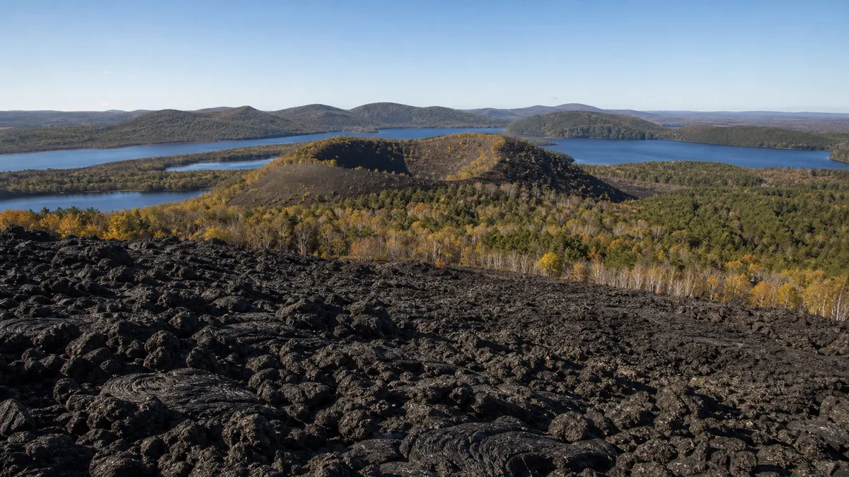
5A View location, maps and nearby scenic areasOn the lower path at Laoheishan, place one boot beside the edge of the managed walkway and look past it—not over the barrier—at the black, clinker-like surface. Then raise your eyes to the round break in the skyline. The broken lava underfoot and the crater above belong to one event sequence; the green islands rooted between them show what happened after the rock cooled.
This is Wudalianchi, pronounced roughly “woo-dah-lyen-chir,” a name meaning five linked lakes. Yet the useful visitor map has four layers: volcanoes, lava, lakes and cold mineral springs. They are connected by origin but not compressed into one short walking loop.
Read the landscape in causal order: if current access allows, begin with Laoheishan’s crater, descend to a managed lava route, move to one viewpoint on the five-lake chain, and finish at an officially open mineral-spring area. Park shuttles can connect parts of that sequence, but routes, boarding points and open trails should be confirmed on the day.
One name covers several landscapes and several boundaries
Wudalianchi is a volcanic field, not one giant crater. Across the wider landscape stand about 14 volcanic cones of different ages, surrounded by lava plateaus, wetlands, forest, farms, settlements, five linked lakes and spring districts. Laoheishan—“Old Black Mountain”—and nearby Huoshaoshan, or “Fire-Burned Mountain,” are the two young cones most closely associated with the historic eruption sequence.
Four official ideas are easy to collapse into one. The 5A scenic area is a Chinese tourism designation. The Wudalianchi UNESCO Global Geopark is organised around geological heritage, education and sustainable local development. The Wudalianchi Biosphere Reserve belongs to UNESCO’s separate Man and the Biosphere Programme and includes conservation, research and community life. Finally, the sub-area shown as open on today’s ticket or notice is an operating boundary.
Those lines do not have to match. UNESCO’s current directory gives 2003 as the biosphere reserve’s nomination year and 2015 as the geopark’s designation date; these are programme dates, not eruption dates. Its biosphere entry covers roughly 1,060 square kilometres, while its geopark entry publishes a smaller area. The familiar count of 14 volcanoes is an orientation figure across a defined field, not a promise that every cone lies inside one ticket or can be visited.
Use the Wudalianchi 5A profile to anchor the map point, then use a dated official scenic-area map for the gate, shuttle stop and legal trail you actually need.
The famous 1719–1721 date is a useful range, not a stopwatch
Wudalianchi is often introduced through the 1719–1721 eruptions that produced the youngest lava around Laoheishan and Huoshaoshan. A 1986 paper in the Journal of Volcanology and Geothermal Research uses that exact range in its title. It remains a practical broad label and explains why these dark surfaces feel unusually legible beside older, more weathered cones.
Historical boundaries are more nuanced. A later study of Manchu-language archives from the Qing administration reports observations at Laoheishan from January 1720 to March 1721, followed by activity at Huoshaoshan in April and May 1721. Different accounts therefore begin the sequence in 1719 or 1720. It is better to say “commonly dated 1719–1721” than to assign every lava tongue to one unqualified day.
The archives also return people to a story often told only through rocks. Officials and observers recorded the place, timing, changing state of the eruptions, dammed water and the personnel involved. Residents had to understand a landscape becoming hazardous and unfamiliar in real time. The modern echo is not merely a date on a sign: monitoring, museums and closure decisions continue the work of turning observation into shared safety.
The 14 cones did not erupt together. Some are much older, and differences in counting can arise from the boundary used and from what researchers classify as a separate cone. Let Laoheishan and Huoshaoshan explain the historic episode; let the broader field explain repeated volcanism over a much longer span.
At Laoheishan, read the crater before collecting viewpoints
If the rim route is open, the climb up Laoheishan is the clearest place to connect source and deposit. Pause below the top and turn around. The cone rises from relatively level country, so even a modest gain in height reveals the dark lava apron spreading outward. At the rim, keep to the managed line and look for the difference between the steep inner wall, the rounded lip and the lower flow field.
Loose scoria, angular fragments and crusts with gas holes record different moments of eruption and cooling. They are not souvenirs. Moving a piece removes context from a protected site and can expose slow-growing lichens or pioneer plants. A black surface is not necessarily “fresh,” and a reddish one is not necessarily hotter or older; oxidation, moisture, minerals, light and weathering all affect colour.
Huoshaoshan belongs to the same historic story but may be managed as a different and more sensitive sub-area. Do not assume a Laoheishan ticket, shuttle or open trail automatically includes it. UNESCO’s geopark profile also reports more than 1,500 small driblet cones, forms built when lava droplets accumulated around gas vents. That number describes mapped geoheritage across a survey boundary, not 1,500 roadside attractions. On an authorised boardwalk, one intact miniature form is worth more attention than a checklist of inaccessible ones.
Wind can be considerably stronger on the rim than below, and cloud can erase the panorama without warning. Railings, one-way controls and temporary closures are part of the interpretation: they show where loose volcanic material and visitor pressure require management.
Lava made the five-lake chain, then life began remaking the lava
The “five linked lakes” are not five volcanic craters filled neatly with water. Young lava obstructed a pre-existing drainage line, ponding water into a connected chain conventionally numbered from First to Fifth Lake. Shorelines, channels and visible connections can vary with water level, vegetation and the viewpoint currently accessible, so one photograph rarely proves that all five are joined.
From a lake viewpoint, frame a dark tongue of lava between water and vegetation. That single view explains the causal sequence better than a distant cone alone: eruption supplied lava; lava blocked flow; stored water created new shores; plants and people adapted to the changed hydrology. The lakes now support habitat, recreation and livelihoods, but they are not separate from the volcanic story.
On the lava plateau, compare blocky rubble with smoother or folded crusts, gas cavities and collapsed surfaces. A hard-looking roof can bridge an empty space. Stay on the boardwalk even when the ground beside it appears stable. Boots damage more than rock: UNESCO highlights Wudalianchi as a place to study primary succession, the slow arrival of pioneer plants on initially bare material. Lichens, mosses, grasses and shrubs are part of the geological lesson because they show time accumulating on a young substrate.
This recovery is not a march toward a single “finished” forest. Exposure, moisture, cracks, fire, trampling and soil depth produce different patches. The contrast between black lava and green growth should prompt restraint, not a search for an untouched patch in which to pose.
Cold springs join ritual, work and claims that need limits
Wudalianchi’s springs are cold mineral springs, not water heated by a steaming magma chamber for visitor bathing. Groundwater moves through rock, dissolves minerals and emerges with a composition and taste that can differ from one outlet to another. UNESCO describes spring tourism, spas, water processing and agriculture as important parts of the reserve’s local economy.
The cultural phrase to listen for is “Holy Water Festival.” UNESCO’s geopark account relates a local legend in which a Daur hunter followed a deer to a spring near Yaoquan Volcano and the water was credited with healing. The story provides a cause—an encounter in the landscape—a turn—the discovery of the spring—and a consequence: communities came to mark water, health and protection together. It is tradition, not a clinical trial.
Today the festival is associated with the Dragon Boat Festival period and brings together several communities. UNESCO notes Manchu, Daur, Ewenki and Oroqen people in the wider geopark; none should be presented as a costume from the past or as the sole owner of every spring practice. Residents, bottling and hospitality workers, guides, researchers and visitors all participate in the spring economy and in debates over use and protection.
Treat “holy,” “mineral-rich” and “commercially bottled” as three different statements. Tie a ribbon or join an activity only where organisers permit, never leave plastic or cloth in vegetation, and do not repeat a healing claim as medical fact. Drink only at a designated outlet under current instructions; a spring closed for testing or maintenance is not made safe by tradition.
Build the day as crater → lava → lake → spring
Start at the visitor centre or geopark museum if weather, shuttle operation or trail status is unclear. A model of the field makes the later views easier to place and offers a worthwhile alternative when wind, ice, storms or maintenance close exposed routes. Ask staff to mark Laoheishan, the specific lava boardwalk, one lake viewpoint and the spring area currently receiving visitors.
For a geology-first day, climb Laoheishan while conditions are stable, then descend to the lava route. Give the crater and flow most of your walking energy. Add one lake view that shows water against the lava dam, then finish near a designated spring without depending on it as a drinking or spa guarantee.
For a lower-strain day, prioritise the museum, a vehicle-served lake edge and a step-minimised spring or lava viewpoint identified by staff. This will not reproduce the crater-rim view, but it can still show the same sequence through models, rock textures, shorelines and water. Ask whether the shuttle accepts wheelchairs or folded mobility aids rather than assuming.
Do not plan by counting names. Roads, car parks and shuttle changes separate the sub-areas, and boarding queues can consume more time than a map suggests. If only two major stops fit comfortably, choose Laoheishan plus the lake chain for cause and consequence, or the museum plus spring district for geology and community life. Confirm the last return from your final stop before leaving the main hub.
Photograph texture, scale and change—not just a black panorama
On Laoheishan, use a person on the legal trail or a curve of railing to scale the cone; do not ask anyone to step onto loose scoria. Side light can reveal pits and folded crusts, while flat midday light often turns the lava into one dark mass. Expose for texture rather than forcing every shadow open.
At the lake, a moderate lens can place lava, water and an older green cone in three bands. A polarising filter may reveal shallows, but rotating it fully can remove the reflection that explains the lake’s calm surface. Wind, haze and cloud change the scene quickly; none is a failed version of the famous view.
For close details, include a boardwalk edge, leaf or handrail at a respectful distance. It makes the scale honest and records the infrastructure protecting fragile forms. Do not enter a lava hollow, climb a driblet cone, collect rock or fly a drone unless current site rules explicitly permit it. Spring areas are social spaces: ask before photographing people filling bottles, bathing or taking part in a ritual.
Cold weather drains batteries, rain makes dark rock hard to meter, and summer storms can arrive when the rim still appears bright. Pack the camera only after you have secured warm layers, water and reliable footwear.
Access and safety depend on the exact open route
Scenic buses can remove road distance; they do not remove crater stairs, rough lava, boarding gaps or long transfers. Laoheishan commonly demands sustained climbing and descent. Managed lava paths can be uneven, narrow or exposed, and seemingly solid crust may conceal voids. Lakeside and museum routes can be gentler, but kerbs, ramps and toilets differ by entrance.
Visitors using wheelchairs, canes or strollers should ask for a route-by-route answer: Which boardwalk is step-free today? Is there an accessible toilet at the destination stop? Can the vehicle carry the device? Is assistance available at the ramp? A staff-confirmed lake or museum circuit is more useful than a general claim that “the park is accessible.”
Weather adds northern scale to a relatively low landscape. Strong wind, lightning, sudden rain, fog, summer heat, winter ice and freeze-thaw damage can close a rim, boardwalk or shuttle. Wear grippy footwear, carry an insulating layer even when the entrance feels mild, and keep children within reach around loose slopes and water. Never cross a barrier to bypass a closure.
Volcanic terrain does not make every smell or bubble an emergency, nor does quiet guarantee permanent inactivity. Follow official monitoring and evacuation instructions, not social-media speculation. For spring water, follow hygiene and consumption notices; for a medical condition, rely on qualified medical advice rather than tourism language.
Leave with four surfaces, not one miracle claim
Return to the first black surface at the end of the day. It now carries at least four readings: erupted rock, a dam that rearranged water, a substrate being colonised by life, and protected ground crossed by workers and visitors. The crater, five lakes and springs are not separate attractions accidentally grouped under one name.
Nor is Wudalianchi only a “natural volcano museum.” Museums select and protect evidence; this landscape is also inhabited, farmed, researched, bottled, celebrated and negotiated. Tourism supports livelihoods and education, while paths, water use and souvenir habits can erode the very textures people come to see. The right balance is not to freeze local life or to treat protection as an inconvenience, but to notice who maintains each safe encounter.
Stand at the lake long enough for the reflection to break. The cone remains, the lava edge reappears, and the water keeps moving through a shape made three centuries ago. That is Wudalianchi’s quieter modern echo: catastrophe became geography, geography became home, and home still requires careful observation.
Continue through Heilongjiang with the forest and granite forms of Tangwanghe Stone Forest, wetland conservation at Zhalong Nature Reserve, or the lived borderland and winter extremes of Beiji Village.
Location profile
Where it is

Frequently asked questions
Are the volcanoes at Wudalianchi extinct?
Do not use the quiet landscape as proof of extinction. Laoheishan and Huoshaoshan belong to a volcanic field with historically documented eighteenth-century eruptions. Visitors should follow current monitoring, weather and closure notices rather than trying to judge volcanic status from steam, smell or appearance.
Can I see Laoheishan, the lava, all five lakes and the springs in one day?
A focused day can normally combine Laoheishan, one managed lava route and a lake or designated spring area when roads and park transport operate. The named sites are spread out, and trying to collect every lake and cone usually leaves too little time to observe any of them. Confirm the open sub-areas and last return before setting priorities.
Can visitors drink Wudalianchi mineral water directly from a spring?
Only use a clearly designated outlet when current rules say the water is suitable for visitors, and follow posted limits and staff advice. Mineral content and hygiene controls differ by source. A local tradition or commercial spa claim is not a medical prescription, and this guide makes no claim that the water treats illness.
Is Wudalianchi accessible for wheelchair users or travellers with limited mobility?
Some museum, lakeside, vehicle-served and spring areas can be easier than the crater climb, but the best-known lava and rim routes commonly include stairs, rough surfaces, gaps and exposed gradients. Ask about the exact route open that day, step-free toilets, shuttle boarding and mobility-device storage; do not assume a scenic bus makes the whole visit step-free.