Heilongjiang · Yichun
Tangwanghe Stone Forest: Granite Among Korean Pines
Read jointed granite beneath a mixed forest, choose a boardwalk or higher trail, and place Yichun's protected landscape within the difficult shift away from commercial logging.
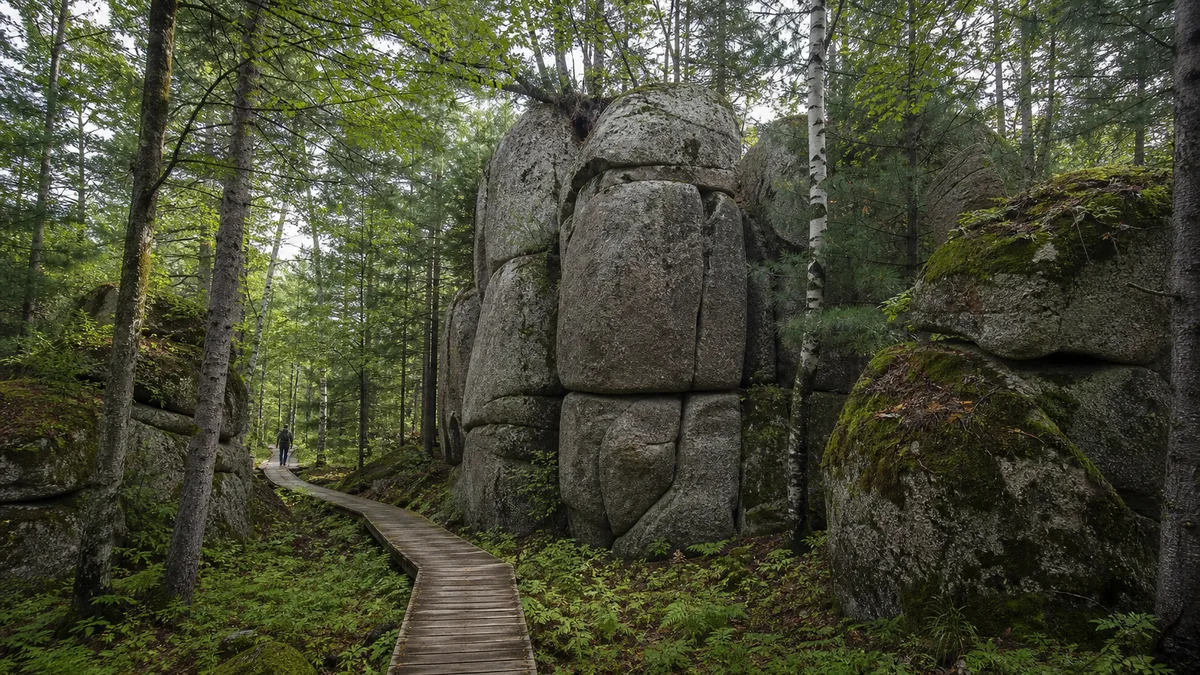
5A View location, maps and nearby scenic areasStop beside one of Tangwanghe’s granite walls and place your attention on a crack. The rock may resemble a tower, animal or human profile, but the crack tells the more durable story: a large granite body was divided along joints, exposed, weakened and slowly separated into the forms now standing among trees.
This is why Tangwanghe Linhai Qishi Scenic Area, often rendered as Tangwanghe Stone Forest, rewards a slower walk. The “forest sea” is not a green backdrop added to a sculpture park. Korean pine, broadleaf trees, roots, moss, water and seasonal frost all influence how the rock is seen and how weathering continues.
Make two choices at the entrance: which trail is actually open, and whether you want a lower forest-and-rock circuit or a longer climb to higher views. Internal shuttles, long routes and winter access are operating conditions, not permanent promises.
Current status, checked 2 August 2026: the scenic area’s official 31 July notice closed the park after heavy rain and said reopening would be announced separately. Do not travel on an older timetable; check the latest official notice or call the published service line at 400-166-0458 before setting out.
Begin with a joint, not an animal name
Many rock groups carry memorable names based on animals, people or stories. Use those names as navigation aids and records of human imagination, not as geological diagnoses. A “tiger,” “general” or “couple” did not determine the rock’s origin, and another viewer may see an entirely different figure from the next bend.
First identify the physical evidence. Granite usually appears coarse-grained, with interlocking light and dark minerals. Straight or curving fractures divide a larger mass into blocks. Some surfaces are rounded by weathering; others remain steep where a joint released a slab. Fallen blocks below a wall show that the landscape is still responding to gravity.
This immediately separates Tangwanghe from two other kinds of “stone forest.” It is not limestone karst shaped mainly by dissolution, caves and underground drainage. Nor is it a volcanic field of lava flows, cones or craters. The granite crystallised below ground, then later uplift and erosion removed overlying material and exposed it near the surface.
Do not climb a named form for a photograph or push into a narrow crack. Weathered granite can shed grains and blocks, moss conceals edges, and a viewpoint barrier may protect visitors from rockfall as well as a drop. The best scale marker is often a person standing on the authorised boardwalk.
Granite becomes a forest of forms one weakness at a time
Fresh granite is strong, but it is not seamless. Cooling, tectonic stress and unloading create joints. Once exposed, rain and meltwater enter those weaknesses. Repeated freezing and thawing can widen them; chemical alteration weakens some minerals; erosion carries away loosened grains. Gravity then removes blocks whose support has failed.
Weathering does not work at one speed. A dense block with few fractures may remain as a broad wall, while closely spaced joints produce narrow pillars or stacked shapes. Corners receive attack from more directions than flat faces and may become rounded. Sheltered sides retain moisture and moss; exposed sides dry faster and show different colour and texture.
Roots usually exploit cracks that already exist rather than splitting an intact mountain in one dramatic act. As roots thicken, organic acids and retained moisture can contribute to local breakdown. Fallen needles and leaves build thin soils in pockets, allowing more plants to establish. Rock helps organise the forest, and the forest modifies conditions at the rock surface.
Look upward only after checking your footing. A vertical composition can show joints continuing through several blocks; a side view may reveal that a “single tower” is part of a longer ridge. Avoid precise ages unless they appear on current geological interpretation. The time of granite formation, the time it was exposed and the much later history of today’s visible surface are not one date.
Korean pine and moss belong to the geological view
Tangwanghe lies in the Lesser Khingan forest region, where Korean pine is a representative tree within mixed conifer–broadleaf forest. Spruce and fir may share the canopy with birch, maple, linden and other broadleaf species. The composition changes with slope, disturbance, moisture and forest history, so “red-pine forest” should not imply a uniform plantation.
In damp shade, moss and lichens soften granite surfaces and hold water close to the rock. They are living cover, not proof that a boulder is untouched or safe to step on. In sunlit openings, drier faces show mineral grains and joint patterns more clearly. Compare both without scraping vegetation away.
Season changes the relationship. Early leaves reveal more rock through the canopy; summer makes the stone seem enclosed in green; autumn colour separates canopy layers; snow simplifies form but hides steps and cracks. After rain, saturated moss deepens in colour and the granite photographs well, precisely when boardwalks and stone steps are most slippery.
Keep food packed and do not feed wildlife. Forest birds and mammals are not scheduled exhibits, and a fleeting sighting should not be chased off trail. In warm months, use repellent, long clothing and a post-walk tick check. Stay out of tall vegetation, and follow local health advice if a tick attaches.
Forest-fire rules outrank the itinerary. Smoking, open flame and unapproved cooking are incompatible with a protected conifer forest. During high-risk periods, entry, route length or activities can be restricted even under clear skies.
Build the route from explanation to boardwalk to height
A useful first visit begins at the entrance interpretation. Photograph the current trail map, note the last internal vehicle and ask which higher or long routes are open. Names used by older blogs may not match today’s signed circuit, and maintenance can turn a nominal loop into an out-and-back walk.
Continue into the lower forest boardwalk. Here the important action is comparison: joints versus roots, dry granite versus mossy granite, upright block versus fallen block. The lower route often provides the clearest introduction and may be the most realistic choice in rain, with children or when walking endurance is limited.
Next choose one or two principal granite groups rather than every silhouette on the map. Walk around only on formal paths. A form that seems flat from the front may reveal separated slabs and deep joints from the side. Let interpretation signs suggest a story, then return to observable texture and structure.
Add a higher viewpoint or long circuit only if time, weather and knees allow. Stairs, roots, uneven stone and sustained ascent can make a short horizontal distance demanding. From above, the gain is not a closer animal shape but a wider relationship among ridge, canopy and exposed rock.
Do not rely on an unconfirmed shuttle for the return. Vehicle stages, last departures and winter service may change with demand, maintenance and road conditions. If you need step-free travel, ask for the exact continuous route from drop-off to viewpoint and toilet; a wooden boardwalk may still include stairs, narrow turns or gaps.
Let named stones guide memory, not replace observation
Figurative names are part of the scenic area’s cultural layer. Guides and visitors use them to share attention, remember turns and create stories. They can make an unfamiliar forest welcoming, especially for children. The problem begins only when resemblance is presented as scientific proof or one legend as the sole ancient meaning.
Try a two-step reading. From the marked viewpoint, notice why the name works: a protrusion becomes a nose, two blocks become figures, a joint becomes a mouth. Then move a few metres along the open path. When the figure dissolves into ordinary slabs, perspective has revealed how the image was constructed.
Local stories should be labelled as interpretation or tradition when documentation is uncertain. There is no need to invent an origin legend for every boulder. The verified story—magma cooling underground, granite exposure, joint-controlled weathering, forest succession and generations of human naming—is already rich.
For photographs, record both readings. Take the familiar silhouette from its signed angle, then a closer frame of mineral texture, joint spacing or vegetation. Moderate side-light reveals relief; fog reduces depth but can separate dark trunks from pale stone. Tripods and drones must follow current rules and should never block a narrow boardwalk.
Leave rocks, moss, cones and bark where they are. Collecting a small specimen still removes material from a protected and heavily visited site. A photograph with a scale and location note is a more useful geological souvenir.
Put the “first national park” phrase back in 2008
Older publicity often calls Tangwanghe “China’s first national park.” The phrase needs a date and an institutional footnote. In September 2008, the former Ministry of Environmental Protection and the former China National Tourism Administration approved Tangwanghe as what authorities then described as China’s first national-park pilot. This was an early departmental experiment, when China did not yet have today’s unified national-park governance and legal framework.
That historical experiment matters: it shows that officials and communities were testing ways to combine conservation, recreation and regional development. But it is not equivalent to the later national-park system under which China’s first group of formally established national parks was announced in 2021. Tangwanghe should not be silently inserted into that list.
The accurate wording is therefore conditional: it was promoted or designated as an early national-park pilot around 2008, and is now reliably visited as a national 5A scenic area and protected forest landscape. Current signs and management categories outrank an undated superlative.
This distinction is more than terminology. “National park” can imply a particular conservation authority, zoning regime and public expectation. Using an older title without context makes visitors misunderstand who manages access and what rules apply. Ask the current scenic-area authority about today’s boundaries, tickets, forest controls and closed zones.
It also leaves room to evaluate conservation honestly. A label alone does not protect soil, prevent fire, manage crowds or support nearby communities. Those outcomes depend on staffing, funding, enforcement and everyday visitor behaviour.
Read Yichun’s forest transition behind the scenery
Yichun developed for decades as a major state-owned forestry and timber-production region. Roads, settlements, skills and family livelihoods were tied to cutting and transporting wood. The forest visible today is therefore not a timeless wilderness without labour; it is also a landscape of use, depletion, tending and policy change.
In 2013, Yichun’s state forest region moved to stop commercial logging of natural forest. The shift protected remaining forest and redirected work toward forest tending, conservation, services and tourism. It also carried real costs: forestry jobs changed or disappeared, workers needed retraining, incomes and local businesses adjusted, and communities had to build identities beyond timber production.
Do not replace that structural history with an invented story about one logger becoming one guide. Without a sourced account, such a character turns difficult change into a neat tourism fable. Look instead for documented interpretation about forest farms, machinery, housing, employment programmes and ecological monitoring.
Tourism is one part of transition, not a complete solution. It can pay for guiding, transport, hospitality and conservation education, while seasonal demand, low wages, road construction and visitor pressure create new vulnerabilities. Buying from local businesses helps, but it does not erase the need for long-term public support and diverse work.
The granite route becomes more meaningful in this context. Protected forest is not simply “nature returning” after people leave. Rangers, former forestry communities, scientists, fire crews and tourism workers continue to shape what survives and what visitors can reach.
Let rain, fire risk and mobility set the pace
Wear shoes with a firm tread even on a short route. Rain, dew and fallen needles make timber and granite slick; moss can hide a polished edge. Use handrails, keep hands free on stairs and give other visitors room on narrow sections. During thunderstorms or strong wind, leave exposed viewpoints and follow staff directions.
Summer requires water, sun protection and insect protection. Check skin and clothing after the walk, especially after brushing vegetation. Never burn incense, smoke or use flame in the forest. Fire-season controls may include ignition-source checks or route closure; cooperate rather than hiding anything that can start a fire.
Winter should never be assumed open. Snow can conceal stairs and joints, ice can stop internal vehicles, and short daylight compresses the safe return window. Confirm the entrance, road, shuttle, trail and last exit directly with the scenic area before travelling. A closed long route is not permission to continue on footprints.
For limited mobility, the lower boardwalk may offer the best experience, but “boardwalk” does not guarantee step-free access. Ask about gradients, stairs, width, rest points, toilets and the boarding gap of any internal vehicle. If only part of the route is continuous, make that section the complete visit rather than treating it as failure.
End photography before the forest becomes too dark to read footing. Keep an offline map and enough time to reach the confirmed transport. Weather, fire safety and access are part of the forest story, not inconveniences outside it.
Leave with rock and working forest together
At the exit, look back at one granite form without its name. It is no longer a solitary sculpture. Joints organised the block; water and frost exploited weakness; gravity removed material; moss and roots changed the surface; a mixed forest altered light and moisture; people gave the form a memorable identity.
The human landscape is just as layered. A timber-producing region restricted natural-forest logging, communities absorbed the cost of transition, conservation acquired new institutions, and tourism invited outsiders to read the result. None of these processes is finished.
A balanced visit therefore does not demand every long trail or animal silhouette. It accepts a wet-weather closure, keeps fire out of the forest, leaves moss intact and treats the boardwalk as protection rather than obstruction. It also remembers that a scenic economy rests on year-round work beyond the visitor season.
Tangwanghe is strongest when “stone forest” stops sounding like a category borrowed from somewhere else. It is a Lesser Khingan granite-and-forest relationship: slow fractures, living cover and a working region learning to protect what once supplied timber.
For basaltic volcanoes and lakes rather than granite weathering, continue to Wudalianchi. For another forest community balancing tourism, climate and daily life, see Beiji Village; for wetland protection and careful wildlife viewing, visit Zhalong Nature Reserve.
LoreLens can help you distinguish granite joints from invented silhouettes, identify forest layers and place the 2008 pilot label and 2013 logging transition on separate timelines.
Location profile
Where it is

Frequently asked questions
Is Tangwanghe Stone Forest a karst or volcanic landscape?
Neither. Its principal rock forms are granite in the Lesser Khingan Mountains. Joints divided the rock into blocks; water, freeze–thaw weathering, chemical alteration, roots, erosion and gravity gradually widened cracks and removed weakened material. The result can look like towers or figures, but it is not dissolved limestone karst and not volcanic lava.
Is Tangwanghe officially China's first national park?
That phrase belongs to a departmental pilot approved in September 2008, before China created today's unified national-park system. It should not be read as equivalent to the national parks formally established under the later system. Tangwanghe is securely described today as a national 5A scenic area and protected forest landscape; check current official categories rather than repeating the slogan without its date.
How long should I allow and which route should I take?
Allow at least half a day for arrival interpretation, forest boardwalks and the principal granite groups. Longer and higher routes need more time, firmer footing and confirmed internal transport. Ask at the entrance which trails, viewpoints and shuttles are operating, then choose one complete circuit instead of collecting every named rock.
When is the best season to visit Tangwanghe?
Summer offers deep green forest but also rain, mosquitoes, ticks and slippery moss; autumn brings colour and clearer rock–forest contrast. Spring fire controls and wet ground can affect access, while winter routes, shuttles and opening status may be greatly reduced or closed. Confirm conditions and carry weather-appropriate footwear and protection.