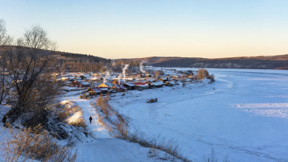
Heilongjiang · Mohe
Beiji Village: Border River, Long Light and Northern Myths
Stand at 53.5°N beside the Heilongjiang, separate long summer twilight from true polar day, and read a border village whose daily life continues behind its ‘northernmost’ signs.
5A View location, maps and nearby scenic areasStand beside the Heilongjiang, near one of Beiji Village’s latitude or “northernmost” markers, and do two things before taking the expected photograph. Face across the border river toward Russia, then compare compass north with the low path of the sun. The river tells you where a state boundary runs; the light tells you how far north you actually are.
This small action is a better beginning than collecting every sign with the character 北, “north.” Beiji Village sits at roughly 53.48°N, close enough to the top of China for dramatic seasonal light, severe winter cold and a powerful northern identity—but still far south of the Arctic Circle. Its real story is richer than the slogans: border geography, an inhabited village, changing livelihoods and a sky that refuses guarantees.
Plan the day as a sequence rather than a trophy hunt: border river and latitude markers → lived village lanes and local interpretation → forest or quiet riverbank. The order keeps the landscape, people and tourism image in the same frame.
Begin at the latitude marker, then turn toward the river
Beiji Village occupies the south bank of the upper Heilongjiang, also known internationally as the Amur. Russia lies across the water. Project coordinates place the village around 53.479°N, 122.360°E; municipal visitor material gives a similar latitude range and describes the main scenic area as approximately 77 kilometres by road from Mohe’s urban centre. Treat the distance as orientation, not a current transfer time: snow, construction, traffic and the exact pickup point all matter.
At the river, find three directions. The opposite bank is another country. Upstream and downstream show that a border is also a moving watercourse rather than a line painted on the ground. North may not be exactly where the most theatrical sign points. A phone compass is imperfect near metal structures, but even a rough check breaks the habit of letting a photo prop substitute for geography.
Look at the sun’s arc as well. In June it travels high enough and long enough to make evening seem delayed. In December it stays lower and the usable day contracts. The contrast explains Beiji Village better than a single “northernmost” monument: high latitude changes the rhythm of work, travel, heating, sleep and outdoor tourism throughout the year.
The Heilongjiang is an international boundary here. A boat on the water, a frozen surface or an inviting sandbar does not erase that fact. Use only authorised river activities and marked viewing areas. Never walk onto the ice or approach the boundary because tracks appear to lead that way; currents, pressure cracks, variable thickness and border rules all remain in force.
At 53.5°N, you are not inside the Arctic Circle
The Arctic Circle currently lies near 66.6°N, more than thirteen degrees of latitude north of Beiji Village. That is a separation of well over a thousand kilometres along a meridian. The village is subarctic in mood and marketed through “Arctic” imagery, but it is not geographically inside the Arctic Circle.
This distinction solves several common confusions. A low winter sun is not proof of polar night. A bright summer horizon after sunset is not a midnight sun. A business called “Arctic” is expressing local identity, not relocating an astronomical boundary. Visitors lose nothing by using the accurate language; the rapid seasonal change at 53.5°N is remarkable on its own.
Latitude also does not act alone. The village lies in the continental interior of Northeast Asia, where land, forest, snow cover and air masses contribute to large temperature swings. Two places on the same parallel can have different climates. Pack for the actual Mohe forecast and wind chill, not for a mental picture imported from Scandinavia or Alaska.
When reading a marker, ask what it marks. It may identify a scenic viewpoint, a cultural symbol or a surveyed coordinate. Few are intended as a precise national extremity. Keep the marker in the photograph, but also include the riverbank, ordinary road or nearby house. Context turns a claim into a place.
Long summer light is real; polar day is not
Around the June solstice, Beiji Village experiences very long daylight and prolonged twilight. The sky may remain pale long after the solar disk has dropped below the horizon, especially when cloud, haze or reflected light softens the transition. Local celebrations often call this a “white night,” and that phrase captures the visitor experience well.
Astronomically, however, the sun still sets. A true polar day—when the sun remains above the horizon for at least 24 hours—requires being at or north of the Arctic Circle, with small variations caused by refraction and the way sunrise is defined. Beiji Village is much too far south. “China’s polar day” or “midnight sun” in promotional copy should therefore be understood as festival language, not an observation you can verify at midnight.
Use the long light deliberately. Start the riverside walk later than you might elsewhere, but verify the last shuttle, closing time and return vehicle before doing so. Blue-hour colour can continue after sunset, yet a pale sky does not mean trails, museums or transport remain open. In June, an eye mask can help sleep in rooms with thin curtains.
Winter reverses the equation. Short daylight compresses photography, driving and outdoor stops, while cold makes every battery change and clothing adjustment slower. Place the most exposed river stop near the brighter middle of the day, then move into village interiors or your lodging before the temperature falls further. “Northern” is experienced as scheduling as much as scenery.
Treat “China’s northernmost” as an identity, not a proof
Beiji Village has successfully built a tourism vocabulary around 找北—“finding north.” Northern post-office themes, compass motifs, border markers and repeated 北 characters turn an abstract coordinate into a playful route. For many travellers this is the best-known place to mark arrival in China’s far north, and that cultural status is real.
The absolute geographic wording is less simple. “Northernmost village” can mean the northernmost administrative unit, village committee, traditional settlement, inhabited house, tourism site or coordinate within a boundary. Beihong Village is often raised in discussions of natural settlements farther north, while other definitions produce other candidates. Boundaries and categories do not fit neatly on one souvenir sign.
There is no need to make the villages compete. Say that Beiji Village is China’s most famous northernmost-themed tourism village, then ask what local residents make of that identity. The phrasing leaves room for geographical precision and for the decades of work that turned a remote border settlement into a national travel symbol.
It also changes the camera habit. Photographing ten “north” signs can make the village look like an outdoor branding park. Add a grocery delivery, stacked firewood, a school-time street, snow clearing or vegetables growing in a short summer. Municipal records describe ordinary village administration and agriculture alongside tourism. Those scenes are not interruptions to the attraction; they show that people live inside the label.
A border settlement lives behind the themed façades
The Heilongjiang has long been a route, resource and boundary. Beiji Village’s households adapted to isolation, forest work, river conditions and overland transport before themed tourism became the dominant public image. Avoid turning that history into one heroic founding date: settlement, administration, border management and livelihood change happened on different timelines, and many online summaries recycle precise claims without showing evidence.
The material evidence is easier to read. Older timber construction responds to an area where forest products were historically available and winter insulation mattered. Heated-kang lodging reflects a cold-climate domestic technology rather than a staged novelty. Wood piles, enclosed porches, heavy doors and compact service spaces explain daily winter routines more clearly than a generic “snow village” caption.
Tourism changed those spaces. A 2025 Mohe municipal profile of Beiji Village homestay operators describes a transition from basic wooden-house and heated-kang accommodation toward themed guesthouses, online promotion and local entrepreneurship. That does not mean every old house is ancient or every homestay preserves an unchanged tradition. It shows residents actively redesigning homes and work for new visitors.
Listen for the modern village as well: electric rental vehicles, delivery traffic, mobile-video shoots and newly styled rooms sit beside heating, snow removal and seasonal food production. Tourism brings income and reasons to improve services, but also pressure on housing, waste, traffic and quiet residential lanes. Ask before photographing people, doorways or private interiors. A paid room is not permission to document the household.
Walk river, village and forest as three distinct chapters
Begin early or late at the border-river chapter, when lower light models the bank. Use authorised paths to connect a latitude marker, an open river viewpoint and whichever public “north” landmarks are operating. Municipal itineraries commonly include the village marker, river views, the northern-themed post office and small museums, but hours, ticket combinations and boat services change. Confirm them at the current visitor centre rather than relying on an old checklist.
Continue through the lived-village chapter at walking speed. Choose one public interpretation space if open, then give equal attention to lane width, winter architecture, kitchen-garden plots and the transition between residences and guesthouses. Buy food or a postcard from a local operator if it suits you; the route becomes less extractive when some spending stays with people who maintain the place.
Finish with the forest-and-riverbank chapter. The edge of the Greater Khingan forest gives the settlement its climatic and material setting. Use only opened boardwalks or roads, keep away from fire-control closures, and do not chase a “wild” viewpoint through vegetation. In summer the quieter edge may be rich in insects; in winter an apparently level path can hide polished ice and deep roadside snow.
This sequence can fit a full day inside the village, but arrival from Mohe and onward travel make for a long day. If you arrive after a train or flight, sleep before building a late-night sky watch. Boat rides, performances, museums, postal services and local vehicles are optional layers, not structural requirements. The route still works when operations change because river, settlement and forest remain legible.
For reduced mobility, the central village roads and some plazas may be more manageable than river stairs, snow-covered boardwalks or forest paths. Ask for the exact step-free chain from vehicle drop-off to river viewpoint, accessible toilet and indoor warming space. “The village is flat” does not guarantee that the desired overlook is reachable.
Let an aurora be a possibility, never a booking promise
Aurora can be observed at unusually low latitudes during sufficiently strong geomagnetic storms, so a genuine sighting from the Mohe area is possible. But possible is not probable on a particular holiday. NOAA’s Space Weather Prediction Center explains that aurora is normally most favourable in an oval roughly around 60–75° latitude; during major storms that oval can expand toward the equator. Beiji Village at 53.5°N generally needs that expansion.
Four conditions must overlap: geomagnetic activity strong enough to move visible aurora southward, true darkness, a clear or sufficiently broken sky, and a viewing direction without strong local light. A summer visit offers long twilight but less darkness—the opposite of what faint aurora needs. Winter provides longer dark windows but can bring cloud, blowing snow and dangerous cold.
Check an official space-weather forecast, not only a viral screenshot. Then check local cloud cover and the moon. Short-range aurora forecasts still express probability and location, not a performance time. Green-tinted camera frames are not always proof: modern phones can amplify faint airglow, artificial light or colour noise that the eye barely sees.
If the forecast is quiet, sleep. If it becomes favourable, choose a legal viewing place in advance, tell someone where you are, keep the river and boundary off-limits, and bring a headlamp, charged power bank and warm backup layers. Do not hire a driver to wait indefinitely without agreeing on the return plan. The responsible story after a no-show is not that the village failed; it is that space weather remained space weather.
Photograph the border without losing your safety margin
For a geographic portrait, place a latitude marker in the foreground and the opposite bank in the distance, then make a second frame without the sign. The pair separates tourism identity from physical setting. Near the solstice, side light late in the evening can stretch shadows through the lanes. In winter, expose for snow carefully so houses and forest do not collapse into darkness.
Border controls outrank photographic ambition. Do not aim long lenses at checkpoints, surveillance equipment, patrol activity or other restricted facilities. Ask local staff before flying any drone; airspace, border-security, scenic-area and temporary-event rules may all apply, and a consumer-app map is not official clearance. Do not photograph residents closely without consent, especially children or private domestic work.
Winter cold can injure before it produces a good image. Temperatures in the Mohe region can fall below −30°C and severe cold can approach or pass −40°C. Dress in removable insulating layers with wind protection, cover skin, carry spare gloves, and use insulated footwear with ice traction. Keep batteries inside your coat, but prevent condensation by sealing cold equipment in a bag before returning indoors. Alcohol creates warmth sensation without preventing heat loss.
Summer has different risks: mosquitoes and other biting insects, strong sun during the long day, heat that can still occur, thunderstorms and occasional high-water disruption. Carry repellent, water, sun protection and a light rain layer. After heavy rain, obey bank closures and never assume a scheduled boat will operate.
Anyone with limited cold tolerance, respiratory or cardiovascular concerns should shorten exposed stops and pre-identify heated shelters. Families need a turnaround rule before children become cold; wheelchair and cane users need both surface information and a snow-clearance update. Confirm the current identity-document, ticket, shuttle, road and lodging rules directly with the scenic area or Mohe tourism authority shortly before departure.
Leave with a measured idea of north
Return to the river at the end of the route, if the authorised path and daylight allow. The same scene should now contain several norths. There is astronomical north, measured by latitude and the sun. There is political north, drawn through a border river. There is lived north, managed through heating, transport, gardening and snow. And there is tourism north, repeated in signs, rooms and souvenirs.
None needs to cancel the others. Accurate latitude does not diminish long twilight. A cautious northernmost claim does not erase Beiji Village’s cultural importance. A missed aurora does not remove the night sky. Recognising a guesthouse as a modern business does not make its heated-kang or timber structure meaningless.
The tensions are part of the destination. Visitor income can support households and interpretation while traffic, staged façades and repeated superlatives can flatten village life. Border rules protect a sensitive landscape but restrict spontaneous exploration. Extreme seasons create the experience and set hard limits on who can stay outside, and for how long.
Take the final photograph only after checking the river, compass and sky once more. You have not reached the Arctic, and you do not need to pretend you have. At 53.5°N, the light lasts unusually long, the winter day closes quickly, Russia remains across the water, and a real village keeps working behind the word “north.”
To compare another Heilongjiang landscape where multiple volcanic sites require deliberate route choices, continue to Wudalianchi. For forest geology shaped into a slower walking route, see Tangwanghe Stone Forest; for a more accessible urban-edge landscape, consider Harbin Sun Island.
LoreLens can help you compare the marker, border river and solar direction on site, while keeping astronomical latitude separate from Beiji Village’s tourism language.
Location profile
Where it is

Frequently asked questions
Does Beiji Village have a true polar day or midnight sun?
No. Beiji Village is around 53.5°N, while the Arctic Circle is near 66.6°N. Around the June solstice the day is exceptionally long and twilight can linger into the night—the local ‘white night’ experience—but the sun still sets. Festival language sometimes uses ‘polar day’ loosely; it should not be read as an astronomical claim.
Can I expect to see the aurora in Beiji Village?
No aurora can be promised. Beiji Village lies south of the latitude band where aurora is normally easiest to observe. A display here generally needs sufficiently strong geomagnetic activity, darkness, a clear sky and an unobstructed northern view at the same time. Check an official space-weather forecast and local cloud forecast, then treat any sighting as a bonus rather than the basis of a fixed itinerary.
Is Beiji Village literally the northernmost village in China?
It is China's best-known ‘northernmost’ tourism destination and a useful symbol of the country's far north, but the absolute claim depends on what is being measured: an administrative village, a natural settlement, a permanent inhabited point or a particular boundary coordinate. Beihong Village and other locations appear in competing claims, so ‘famous northern tourism village’ is more precise than an unqualified geographic superlative.
What should foreign visitors confirm before travelling?
Confirm the currently accepted identity document, any reservation or border-area registration requirement, the correct entrance, transport from Mohe, and rules for river access, boats, drones and photography near boundary facilities. Operations and controls can change. In winter also confirm road and trail conditions; never treat the frozen border river as a crossing or an automatically safe walking surface.