Xinjiang · Bayingolin
Bayanbulak Grassland: The River That Cannot Run Straight
Nine suns in one river at sunset, the meander physics that puts them there, the southernmost wild swans in the world, and a nation that walked back from the Volga in 1771.
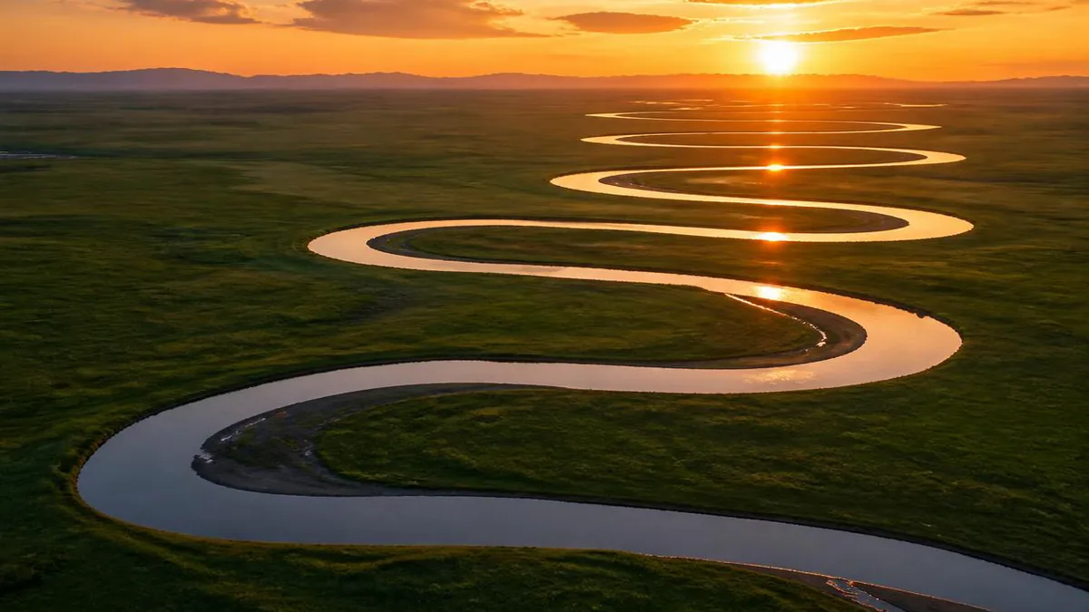
5A View location, maps and nearby scenic areasAt sunset on the Bayanbulak grassland, the people standing on a hill above the Kaidu River are counting suns. Two is easy; staff at the viewpoint say five or six is what most visitors go home with. Nine is the number in the name of the phenomenon—jiuyang lianzhu, nine suns strung like beads—and nine is rare.
The count is neither a miracle nor a metaphor. Every sun is the same sun, reflected off a different reach of one river that turns so many times across this basin floor that several stretches of water can face the low light at once.
Which leaves the real question: why does a river bend like that? Almost everything here—the marsh, the swans, the herders moving in June, even the reason a Xinjiang county sits inside a Mongol autonomous prefecture—hangs off the answer.
A basin the mountains made, then filled with their own debris
Bayanbulak—Mongolian for “abundant spring”—is not a plain. It is a pair of high intermontane basins in the mid-Tian Shan, in Hejing County of Bayingolin Mongol Autonomous Prefecture, ringed by mountains that mostly exceed 3,000 metres and hold snow all year.
Chinese descriptions put the grassland at 23,835 square kilometres, roughly 270 kilometres by 136. Elevations are quoted inconsistently: commonly 2,000 to 2,500 metres, the reserve at 2,300 to 3,100, the research station at 2,470. Treat any single figure with suspicion.
The structure matters more than the statistics. This is a Mesozoic intermontane fault depression whose floor is blanketed in Quaternary sediment—a hole made by tectonics, then filled with debris off the ranges around it. Across the middle runs the Erbin Mountain, some 170 kilometres long and about 50 wide, splitting the grassland into the Greater and Lesser Yulduz basins.
Water arrives as snowmelt, rain and groundwater: counts give 13 springs, 7 lakes and 20 rivers.
Why a river on a flat floor cannot stay straight
The mechanism is visible from the viewpoint once you know what to look at. Three conditions overlap here. The gradient is low: the Kaidu is crossing basin fill, not descending a mountain front. The banks are erodible: loose Quaternary sediment held together mainly by turf. And the channel is unconfined: the valley is tens of kilometres wide, so nothing stops the river swinging sideways.
Given those, a bend feeds itself. Water rounding a curve is thrown outwards and piles higher against the outer bank; that superelevation drives a return flow along the bed towards the inner bank. The resulting corkscrew circulation scours the outer, concave bank and deposits on the inner, convex one. Every curve grows sharper, and the river lengthens without going anywhere, until two limbs of a loop meet, the neck is cut, and the loop is left behind as an oxbow lake. The basin is full of them, and they are the proof.
Reading this yourself costs nothing. Pick one bend: the outer side is the steeper, barer, sometimes undercut edge, the inner a low shelf of fresh sediment, often paler and greener. That contrast is the mechanism, live. Then find an oxbow: research on meander cutoffs reports that around 84% of neck-cutoff oxbows are skewed towards the upstream direction, so the shape of the crescents alone tells you which way the river runs, with no compass and no sign.
One honesty note: sources give the Kaidu a fall of about 1,750 metres over 500-odd kilometres but publish no gradient for this reach, so the low slope here is inferred from the landforms.
The nine suns are a mirror trick, not an omen
Everything above is why the sunset works. Because the river doubles back on itself repeatedly, one low sun can be mirrored by several separate water surfaces at once, each reach that lies square to your line of sight throwing back its own image. String those together and you get the beads. Fail on any one condition—too little water, wrong azimuth, haze at the horizon—and you get three.
The platforms sit on a hill near the Basilik visitor centre, at the far end of the shuttle road, on a boardwalk with several decks at different angles; the widest-open one is usually the most crowded.
Timing is where the sources disagree, and it is worth saying so. Most reporting points to the weeks around the Mid-Autumn Festival, in the second half of September, when the sun sets far enough south to line up with the run of the bends. At least one account instead names the period around the summer solstice. Both claims exist; neither is settled here.
One practicality: Xinjiang runs on Beijing time, so a July sunset can fall after 21:45 by the clock, and the disappearance takes about two minutes. Arrive early, dressed for cold.
What “Swan Lake” actually means
Swan Lake is a marketing name and a serious piece of conservation: a provincial swan reserve from 1980, raised to national level in 1986, and described as China’s first reserve created for swans.
Then the species question, where popular and specialist accounts split. Popular accounts list three swans here: whooper, mute and tundra. Ma Ming, an ornithologist who ran the Bayanbulak ecological station and held a national grant for swan breeding research from 1991, states that the bird that breeds here is the whooper swan, the southernmost breeding population known, and that mute and tundra swans were recorded in the past but are now hard to find. The distinction has teeth, because the tundra swan breeds on Arctic tundra—birds counted here under that name are better read as passage or summering birds than as nesters.
The breeding calendar is well documented locally. Birds arrive through March and April; territory, nest-building and laying begin in late April, on nests at the water’s edge often reused year after year. Clutches run 3 to 8 eggs, averaging five, and the female incubates alone for 30 to 35 days. Cygnets practise flight at about three months; departure south begins in late September.
One thing follows: the season when these birds most need protecting is not the season when they are easiest to see. Late spring is nesting, when disturbance costs most of all.
Population figures conflict badly. One account gives over 20,000 swans in the 1980s falling to roughly 2,000 by 2001; Ma Ming describes ten thousand pairs in the 1940s and barely a thousand after a catastrophic snow year in 1996. The reserve authority reported more than 8,000 whooper and over 2,000 tundra swans in 2023—a count that sits awkwardly beside the paragraph above.
The wetland halves itself between August and October
The marsh looks permanent in July. It is not. Remote-sensing work tracked the wetland’s extent month by month through one growing season and found it stable at roughly 74 to 81% of the study area up to August, then contracting fast—down to about 39% by October, with mean monthly temperature the main control. The wetland you photograph is a summer maximum, and the sedge beds around the swan nests are a seasonal condition rather than a fixture.
The cold explains the rest. At the station at 2,470 metres the annual mean is given as about −4.8°C, with January lows near −48°C, snow cover for 150 to 180 days, and—the phrase Chinese sources use—no absolute frost-free period. A national normal for 1991 to 2020 is milder, near −4°C, with a record low of −49.6°C. Precipitation lands between 276 and 301 millimetres, about 70% of it in June to August.
That is a subarctic climate at the latitude of Barcelona, held there by altitude and by a basin that traps cold air once it settles. Groundwater sits within a metre of the surface, which is why sedge marsh, not steppe, holds the floor.
1771: eight months, and half a people
The human story here is one journey rather than a list of names. The Torghut were one of the four Oirat Mongol tribes. Around 1630, unwilling to be absorbed by the rising Dzungars, they moved west from Tarbagatai to the lower Volga and founded what became the Kalmyk Khanate. Contact never entirely broke: an embassy from their khan reached Beijing in 1712.
Pressure built as Russian administration tightened. When Ubashi succeeded as khan in 1761, aged nineteen, the council that had held the khan’s highest authority was put under the Russian foreign ministry and its members onto salaries, while a rival was cultivated inside the tribe.
In autumn 1770 Ubashi convened a secret assembly and swore to leave. The plan leaked, forcing an early start in January 1771. It was a warm winter and the Volga did not freeze hard, so the ten thousand-odd households on the west bank could not cross—they stayed, and their descendants are today’s Kalmyks. From the east bank, accounts give over 33,000 households and roughly 169,000 people setting out.
What followed was eight months and close to ten thousand li: a forced crossing of the Ural, a fighting passage across the Kazakh steppe, disease, and a detour through gravel desert where, one record says, people drank the blood of their animals. They reached the Ili that summer. Of those who set out, a Chinese source puts the arrivals at “half, by count.”
Why there is a Mongol autonomous prefecture in Xinjiang
The aftermath is what put this grassland on the map.
The Qing court sent relief, then assigned pastures. Qianlong received Ubashi at Chengde in September 1771 and had two texts on the return carved on stelae at the Putuo Zongcheng Temple. Over 1772 and 1773 the Ili general Shuhede allotted grazing land, Bayanbulak among the districts handed to the returning groups.
Ubashi’s own people were first wintered at Zair. He asked repeatedly to move, chose the Jüldüs grassland—this basin—and by 1774 had relocated. That is why the map reads as it does: pastoral geography set by an eighteenth-century resettlement, formalised much later when the Bayingolin Mongol Autonomous Prefecture was established in 1954.
One built trace is worth stopping for. The Barun Kure temple—a shuttle stop between Swan Lake and the viewpoint—was for most of its history a moving monastery: chapels and monks’ quarters in yurts, migrating with the herds, a permanent building completed only in 2011. Down in Baluntai, the Yellow Temple, head temple of the southern Old Torghut, went up in the late 1880s to commemorate the return.
A working summer pasture with a schedule of its own
This is not a park with animals in it. It is one of the richest summer pastures on the southern Tian Shan, and the people in it are working.
Herding families hold winter, spring-autumn and summer pastures and move between them: zhuanchang, the seasonal transfer. Winter ground sits low in sheltered valleys, summer ground high where rain and grass are best, the low hills between serving as a staging area. Distances vary wildly: one herder was reported moving 500 sheep and 20-odd cattle over 120 kilometres in two or three days, while other families need half a day, or a week. A recent county schedule ran the summer move from 1 June to about 20 June.
The pressure shows. Grazing figures range from 600,000-plus head to some 1.5 million sheep, with overgrazing noted nearby, an invasive lousewort (Pedicularis kansuensis) degrading pasture, and restoration trials sowing oats and alfalfa across 15,000 mu.
Two consequences: yurts are homes, so ask before photographing people or animals at close range; and in the first three weeks of June you may share the road with several hundred thousand sheep.
Plan for one road, one shuttle and a very late sunset
The scenic area became a national 5A site in November 2016, and Bayanbulak was inscribed in June 2013 as a component of the Xinjiang Tian Shan World Heritage property. Practically, that means a managed circuit.
Private cars are not admitted. Access is by internal shuttle—roughly 45 kilometres one way and about an hour, with stops at the swan area (26 km), Barun Kure (35 km) and the Basilik visitor centre at the end, from where a cart, a horse or your own legs get you up to the viewpoint. Fares differ substantially between sources and years, so confirm the current prices, the circuit and the last departure at the gate, not from any itinerary written earlier—including this one.
Clothing is the item people get wrong. Plan for a summer afternoon in the low twenties and an evening that drops hard within an hour of the sun going, on open grass with no shelter—a windproof shell and real insulation, carried up the hill rather than left in the car.
Wait for the light to go, then look down at the grass
When the last sun has gone out of the last bend, most of the boardwalk turns around and walks off.
Give it ten more minutes and look down instead of west. You are standing over a floor of debris shed by the ranges around you, a river too slack to hold a straight line, and a marsh that will be less than half this size by October. The swans on it are the southernmost of their kind, nesting at the edge of shallow water—shallow because the river keeps abandoning its own loops. The people whose lamps you can see are here because a khan asked for this basin in the 1770s, after walking most of a nation back from the Volga.
None of that shows in a photograph of nine reflections. But the reflections are the mechanism making itself visible for two minutes—and the mechanism is what to carry out.
Location profile
Where it is

Frequently asked questions
Why does the Kaidu River bend so much at Bayanbulak?
Three conditions overlap on this basin floor. The gradient is very low, because the river is crossing the flat fill of an intermontane depression rather than descending a mountain front. The banks are loose Quaternary sediment held together only by turf, so they can be cut sideways. And nothing confines the channel—the valley is tens of kilometres wide, so the river is free to swing. Once a bend exists, secondary flow inside the curve drives surface water against the outer bank and returns along the bed towards the inner bank, so the outer bank erodes while the inner bank builds a point bar. That feedback deepens every curve it starts, until a neck closes and the abandoned loop is left behind as an oxbow lake. Chinese sources give the whole river a fall of about 1,750 metres over 500-odd kilometres but do not break that out reach by reach, so treat the low gradient here as read off the landforms rather than quoted from a gauge.
Which swans actually breed at Bayanbulak's Swan Lake?
Be careful with this, because popular accounts and specialist accounts differ. The reserve is routinely described as hosting whooper swans, mute swans and tundra swans. Ma Ming, an ornithologist who ran the Bayanbulak ecological station and held a national grant for swan breeding research, states that the breeding bird here is the whooper swan—the southernmost breeding population known—and that mute and tundra swans were recorded in the past but are now hard to find. That matters because the tundra swan breeds on Arctic tundra, so birds counted at Bayanbulak under that name are best read as passage or summering birds rather than nesters. Population figures also conflict: over 20,000 swans in the 1980s falling to roughly 2,000 by 2001 in one account; the reserve authority reporting more than 8,000 whooper and over 2,000 tundra swans in 2023.
When can you see the nine-sun sunset, and is it guaranteed?
No. Nine reflections require high enough water, the right sun azimuth against the run of the bends, and clear air at the horizon at once, and viewpoint staff say most visitors photograph five or six. Reporting converges on the weeks around the Mid-Autumn Festival, in the second half of September, as the most favourable window, though at least one account points instead to the period around the summer solstice; the two claims sit in the sources unresolved. Also budget for Xinjiang's time gap—the whole region runs on Beijing time, so a July sunset can fall after 21:45 by the clock, and the last shuttle back is late in the evening. Confirm opening hours, shuttle timings and the final departure at the gate on the day.
How cold does Bayanbulak get, and what should I pack?
This is a genuinely cold place rather than a cool one. The research station at 2,470 metres gives an annual mean around −4.8°C, January lows reaching about −48°C, 150 to 180 days of snow cover a year and no absolute frost-free period; a national meteorological normal for 1991 to 2020 gives a milder annual mean near −4°C with a record low of −49.6°C. Summer visits still need layers, because the daily swing is large: a summer afternoon can sit in the low twenties while the temperature drops sharply within an hour of sunset, on an open grassland with no windbreak. Bring a windproof shell and real insulation for the sunset wait, whatever the forecast for the middle of the day says.
Sources and further reading
Background references for the history and place names in this guide. Opening hours, ticketing and access change often — always confirm with official local information before travelling.