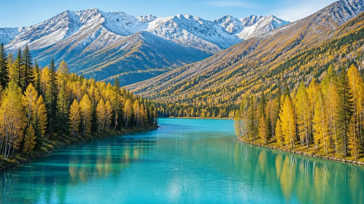
Xinjiang · Altai Mountains
Kanas Lake: The Water That Leaves China for the Arctic
A moraine-dammed lake in the Altai that changes colour by the month, three surviving Tuvan log villages, and the only river system in China that drains towards the Arctic Ocean.
5A View location, maps and nearby scenic areasMost Chinese rivers you can name run east. The Yangtze, the Yellow River, the Pearl—all of them end in the Pacific. Stand at Kanas Lake, in the far north of Xinjiang where China meets Kazakhstan, Russia and Mongolia, and you are looking at the exception. The water leaving this lake flows into the Kanas River, joins the Hemu River to form the Burqin, empties into the Irtysh, and from there travels across Kazakhstan and Siberia to the Arctic Ocean.
That single fact reframes the whole valley. This is the only part of China drained by an Arctic river system, and almost everything distinctive here—the fish, the trees, the light—follows from being on the wrong side of the watershed.
A lake that glaciers built, then plugged
Kanas sits at 1,374 metres above sea level, runs roughly 24 kilometres north to south, covers about 45.73 square kilometres, and reaches 188.5 metres at its deepest. That depth makes it the deepest moraine-dammed lake in China, formed around 200,000 years ago.
The word “moraine-dammed” is doing real work in that sentence. Chinese surveys describe three overlapping causes: tectonic subsidence opened the valley, valley glaciers scoured it deeper, and then a terminal moraine—the rubble a glacier pushes ahead of itself and abandons when it melts back—sealed the lower end. That plug is described as roughly 1 kilometre wide and 50 to 70 metres high. Meltwater collected behind it, and still does.
One detail is worth carrying up to the viewpoints: the lake’s cross-section is close to a symmetrical box, a flat floor with steep parallel sides. Surveys note this shape is rare in China and closer to the glacial trough lakes below the European Alps. You cannot see it from the shore, but it explains why the water goes dark so abruptly a short distance out.
The colour is a mechanism, not a mood
Kanas is marketed as the “colour-changing lake,” which sounds like the sort of claim that dissolves on arrival. It does not. There are three identifiable processes, and they compete.
Upstream sediment. About 40 kilometres above Kanas lies a smaller lake ringed by limestone, usually called the White Lake (Ak-Kul), named for its milky, semi-translucent water. It sends fine pale material downstream.
Rock flour. The Kanas glacier, on the southern slopes of Friendship Peak, grinds across light-coloured granite. The powder that grinding produces—rock flour, in glaciology—travels in the meltwater. When summer melt peaks, so does the whiteness.
Reflection. The rest is optics: forest colour, sky colour, sun angle, and where you happen to be standing.
Accounts converge on a rough calendar. Grey-green in May. Green or blue-green in June as the slopes leaf out. A milky, blue-tinged cast from July, the flood season, when upstream supply is highest. Darker, ink-green in August after rain. Jade in September and October as inflow drops and the water clears. From December the surface freezes hard enough that herders have traditionally crossed it with sledges.
Read that list as tendencies rather than a timetable. Two visitors a week apart, in different light, will honestly describe different lakes.
Climb the 600 metres to the Fish-Viewing Pavilion
The Fish-Viewing Pavilion sits at about 2,030 metres on Halakat—“Camel”—Peak, roughly 600 metres above the water. From the shore, Kanas is a series of disconnected bays. From up here, close to three-quarters of the surface resolves into one crescent, and the box-shaped basin finally makes visual sense as a single trough rather than a chain of coves.
The climb is also the best place to understand the forest. Kanas is the core of a national nature reserve covering some 5,588 square kilometres, spanning 1,300 to 4,374 metres in elevation. The trees are Siberian: larch, spruce, fir, Siberian pine, with birch filling the disturbed ground. Roughly 798 plant species are recorded here, about 30 of them classed as rare. This is boreal forest that reached its southern limit and stopped—another consequence of that Arctic-facing watershed.
If you arrive on an August morning after rain, mist often fills the valley floor. Between about 9 and 10 a.m., when the sun reaches a particular angle, a large semicircular coloured ring is sometimes reported in the mist over the western slopes—a glory, in optical terms, locally described as Buddha’s light. It is said to last about a quarter of an hour. Like all atmospheric optics, it is a matter of luck rather than schedule.
Three bays, each cut a different way
Downstream of the lake, the Kanas River carves three well-known bends—Fairy Bay, Moon Bay and Dragon Bay—usually visited in that order along the boardwalks.
Fairy Bay is the widest reach, and the one people come for at dawn: mist sits on blue-grey water and the light arrives through cloud. Morning fog is enough of a draw that from mid-September there are said to be early trains specifically for it.
Moon Bay lies about a kilometre upstream of Dragon Bay, where the channel doubles into a reversed S and leaves a half-moon of water. Two grass-covered platforms sit mid-channel, formed by collapse and locally called the fairy’s footprints. The viewpoint is up on a switchback road some 60 metres above the river, which is what makes the crescent legible.
Dragon Bay is the calmest and greenest, slowed almost to stillness, with a densely vegetated sandbar down its middle that reads convincingly as a sleeping dragon.
All three are river bends rather than lake shore. Widening, slowing, meandering, collapsing—the mechanics on display here are the same ones that eventually built the whole valley floor.
The log houses are climate engineering
Three villages remain inside the scenic area: Hemu, Kanas and Baihaba. These are the last three Tuvan settlements in China, and their total population is small—commonly given as around 2,000 people.
Look closely at how a house is built rather than photographing it from across the meadow. Walls are single-thickness logs, thirty to forty centimetres in diameter, notched at both ends so each course locks into the next. A substantial part of the structure sits low into the ground, against roughly half a year of severe cold. The roof is a steep pitch built up from boards, and between the flat interior ceiling and the outer spire there is a storage void used for food and fodder.
That last feature is the one to remember: descriptions note it appears only in these three Tuvan settlements. It is not decoration. It is insulation, drainage and a pantry solved in one geometry, by people who had to overwinter here without imported materials.
Hemu is the largest and most remote of the three, about 35 kilometres and roughly an hour’s drive from the main scenic area, with birch woods along the Hemu River. Baihaba sits directly on the Kazakhstan border and is the harder one to reach—see the note on permits below.
A language that was never written down
The Tuvans are officially counted within China’s Mongolian nationality, but they are a Turkic-speaking people whose homeland lies in what is now the Russian republic of Tuva. They have lived around Kanas for something on the order of four centuries.
Their language survives here orally only. There is no local writing system for it, which means the community’s history has been transmitted by speech and song rather than documents. According to tradition, these families descend from soldiers left behind during Genghis Khan’s westward campaigns—a story worth repeating as a story, since a claim of that age transmitted without writing cannot be verified the way a written lineage could.
The practical consequence for a visitor is worth stating plainly: when a language has roughly two thousand speakers and no script, every conversation is part of the archive. That is a reason to be a careful guest rather than a reason to treat a village as scenery.
The monster, and the fish that is actually there
Local tradition describes a large creature in the lake that could raise mist and take livestock from the shore. In 1980 a sighting report ran in a national newspaper and the story became national news.
Then the surveys started. During a 1985 expedition tied to establishing the nature reserve, team members reported seeing very large red fish from the surface; the expedition leader, a biologist from Xinjiang University, published the observation and it circulated widely. Further sightings followed—a disturbance in 2005, footage broadcast on national television in 2012.
Here is where honesty matters more than atmosphere. Ichthyologists who examined the case converged on a specific animal: the Siberian taimen, a large predatory salmonid whose skin turns reddish-brown while breeding, which is why locals call it the big red fish. It is a genuine apex predator, sometimes nicknamed the tiger of the water, and a confirmed specimen from the lake measured about 1.45 metres—long, flat-headed, with teeth on jaws and tongue alike.
But the reported ten-metre animals have never been landed. Confirmed captures here have not exceeded roughly two metres. Surveys in 1988 concluded the species could not plausibly reach four or five metres in this lake, and a separate two-month expedition put the ceiling at about four metres. There is also a hydrological objection: the channels above and below the lake are narrow and shallow with rocky bars, which makes the salmonid migration the legend implies hard to explain. Repeated surveys by national institutes have found no large aquatic animal here other than the taimen.
So the lake does hold a formidable cold-water fish, in company with grayling, lenok, burbot and other Arctic-system species. It very probably does not hold a monster. Both halves of that sentence are worth knowing before someone on a boat points at a wave.
Order the valley by elevation, not by map distance
Kanas frustrates people who plan it as a list of named sights. The distances look small and the days fill up anyway, because almost every movement here is vertical or shuttle-dependent.
A more useful mental model is three tiers. The river bends—Fairy, Moon and Dragon Bay—sit lowest, strung along the boardwalks below the lake, and reward early morning when mist is still in the channel. The lake and its viewpoint sit above that, and the Fish-Viewing Pavilion is a genuine climb of some 600 metres above the water, so it belongs to a fresh half-day rather than the tail of one. The villages sit off to the sides: Hemu is roughly an hour’s drive out, and Baihaba further still and behind a border check.
Read that as an argument for staying at least two nights. A single day forces the worst version of the trip: bays in flat midday light, the viewpoint climbed in a hurry, and no village at dawn, which is the one hour a log settlement genuinely looks the way photographs promise.
One more sequencing note. If autumn colour is your reason for coming, the larch turn is the variable you cannot control—it moves by week and by elevation, and the gold you see at village level may be a fortnight ahead of the gold higher up the valley. Build a spare morning into the plan rather than a spare afternoon.
Planning around cold mornings and a short season
The window everyone wants is late August to early October, when larch and birch turn gold against dark spruce. June to August is greener, milder and less crowded at the viewpoints.
Whatever the month, plan for the daily swing. Early mornings in the valley can sit near or below freezing while a summer midday climbs above 20°C, so layers are not optional. Autumn is also peak season for shuttle capacity and village accommodation, and the two constraints interact: the light you came for arrives at the coldest, busiest hour of the day.
Two practical items to confirm rather than assume. Baihaba is in a border zone, and border-area travel in China normally requires a permit arranged in advance; rules and checkpoints change. And ticket, shuttle and internal transport arrangements vary between sources and seasons—check the current circuit at the gate rather than trusting an itinerary written a year ago.
Look at the outflow before you leave
Before you head back down, find where the water leaves the lake.
It is an unremarkable-looking channel. What makes it worth two minutes is where it goes: north and west, through the Irtysh, across Kazakhstan and Siberia, to the Arctic. The larches around you are Siberian for the same reason the fish are Arctic-system fish—this valley faces away from the rest of China, and its biology followed the drainage rather than the border.
That is the most useful thing to carry out of Kanas. Not that it is beautiful, which you will already know, but that it belongs to a different watershed, and that the glacier which dug and then dammed it left the plug still holding.
Location profile
Where it is

Frequently asked questions
Why does Kanas Lake change colour?
Three mechanisms overlap. Upstream, a lake commonly called the White Lake (Ak-Kul) sits among limestone and sends pale, fine sediment downstream. The Kanas glacier grinds light-coloured granite into rock flour that enters the water as meltwater rises. And the surrounding forest and sky are reflected off the surface, so the colour you see also depends on season, weather and the angle you stand at. Broadly, accounts describe grey-green in May, green or blue-green in June, a milky cast in the July flood season, darker green in August, and jade tones in September and October.
Is there really a monster in Kanas Lake?
There is a long local tradition of a large creature, and sightings have been reported since at least 1980. Scientific surveys have consistently pointed to a real fish instead: the Siberian taimen, whose skin turns reddish-brown in the breeding season and which locals call the big red fish. Specimens confirmed from the lake have not exceeded roughly two metres, and researchers who examined the reports concluded the fish could not reach the ten-metre lengths described. Treat the monster as folklore with a real animal behind it.
Do I need a permit for Baihaba village?
Baihaba sits on the border with Kazakhstan, and border-area travel in China normally requires a permit arranged in advance. Requirements, checkpoints and which travellers may enter can change, so confirm the current rule before committing to a Baihaba night rather than assuming access.
When is the best time to visit Kanas?
Late August to early October is the most sought-after window, when the larch and birch turn gold. June to August is milder and greener. Whenever you go, plan for a wide daily temperature swing—early mornings can sit near freezing while summer middays climb well above 20°C—and remember that autumn is also the busiest period for shuttles and village beds.
Sources and further reading
Background references for the history and place names in this guide. Opening hours, ticketing and access change often — always confirm with official local information before travelling.