Xinjiang · Tianshan
Tianshan Grand Canyon: The Green One, Not the Red One
A 5A canyon an hour south of Ürümqi where the spruce grows on one wall and not the other, Kazakh families still take their animals up in June, and the name it shares with a famous red gorge sends visitors 500 kilometres wrong.
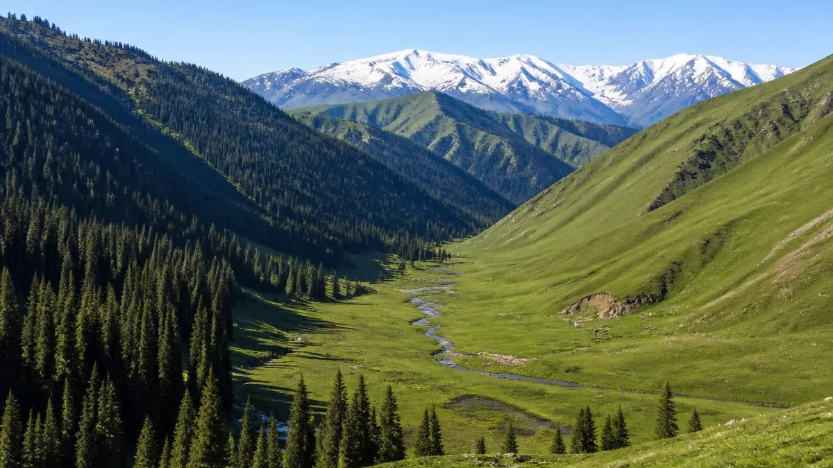
5A View location, maps and nearby scenic areasType “Tianshan Grand Canyon” into any search box and you get two entirely different sets of photographs. In one, a slot of red rock narrows until two people cannot pass abreast, the sky reduced to a crack. In the other, dark conifers stand on a wet green slope above a reservoir, with white yurts on the meadow and a snow line beyond.
Only one of those is the National 5A scenic area 48 kilometres south of Ürümqi. It is the second one: green, with no red rock and no slot. The reason you may have expected otherwise is that a great deal of published material—including English pages about this place—has quietly merged it with a famous canyon on the far side of the mountains.
The name belongs to two places, and the sources have merged them
The other canyon is the Tianshan Mysterious Grand Canyon, near Kuqa in the Aksu region, on the southern flank of the range. Chinese sources also call it Kizilya, from a Uyghur phrase meaning red cliffs, which is the honest description: the gorge is cut in red sandstone and conglomerate laid down in the Cretaceous, then folded as the Tianshan rose. Its mouth lies roughly 64 to 72 kilometres from Kuqa city; the gorge narrows to about 0.4 metres in places and averages near 1,600 metres elevation. About 1,400 metres inside, 35 metres up the cliff, is the Aai Grottoes, a mid-Tang Buddhist cave whose inscriptions mix Chinese donor names with Kuchean script.
Now the contamination. English introductions to the Ürümqi scenic area routinely open with “Tianshan Grand Canyon, aka Keziliya Grand Canyon”—transplanting the Kuqa name onto a place with no red cliffs at all. Chinese encyclopedia listings for the Ürümqi site have included the Aai Grottoes among its attractions, which would require a detour of several hundred kilometres across the range.
So carry a filter. Red rock, slot walls, grottoes, southern flank, Kuqa: that is the other one. Spruce forest, meadow, yurts, reservoir, northern flank, Ürümqi County: that is this one.
Where the green one actually sits
This canyon lies in Ürümqi County, across Banfanggou, Tuoli and Shuixigou townships, at roughly 43°26′N 87°22′E. It occupies the northern flank of the Karawucheng range in the middle Tianshan, between Bogda Peak (5,445 m) to the east and Tianger Peak (4,562 m) to the west, with the Junggar Basin opening north.
The headline figure is a trap. The planned area is 1,038.48 square kilometres, about 49 kilometres north to south and 42.5 kilometres east to west. That is not the area you visit—it is a management boundary running from a forestry station to the Toksun county line, and most of it has no road, no trail and no visitor. Most of the walkable ground sits between roughly 1,500 and 2,500 metres, running from the reservoir dam at about 1,900 metres up to the Tianmen viewpoint just above 2,700 metres.
Average elevation is given as 2,000 to 2,020 metres, mean annual temperature 4–6 °C, winter around −15 °C and summer around 21 °C, frost-free period 150–160 days. Annual precipitation is quoted across a wide band, 330 to 600 millimetres, of which winter supplies only about 5 percent and spring plus summer about 65 percent. Hold the range loosely; hold the seasonality tightly, because it governs everything below.
The forest grows on one side of the valley, and you can see the line
This is the thing to actually look at, and you can check it from the shuttle window. The dominant tree is Schrenk spruce, Picea schrenkiana, known in Chinese as the snow-ridge spruce. On the northern Tianshan it occupies a belt from roughly 1,400 to 2,800 metres and carries more than 90 percent of the range’s forest land. Mature trees reach 50 to 60 metres with trunk diameters near a metre, which is why one Chinese nickname translates as sky-gazing tree.
But within that belt the forest is restricted to north-facing and half-shaded slopes; studies place the forest zone at about 1,720 to 2,700 metres with P. schrenkiana confined to moist, shaded aspects. Look across the valley and the asymmetry is blunt: one wall almost black with conifer, the facing wall pale grass with trees only along gullies. Same rock. Same rainfall. Same elevation.
The mechanism is a water budget, not a temperature one. In an arid range moisture is the limiting resource, and a north-facing slope takes less direct sun, so it evaporates less, holds snow later into spring, and keeps soil damp long enough for a shade-tolerant seedling to survive its first summers. Turn that slope south and the same seedling cooks. Grass, which finishes its business in weeks rather than decades, does not care.
One honest footnote: “primeval” does not mean self-sustaining. An eight-hectare Tianshan monitoring plot recorded 8.82 percent mortality against 2.19 percent recruitment between 2009 and 2014—a net loss of stems in five years. The forest you are photographing is not obviously replacing itself.
Read the altitude bands, not the viewpoint list
The whole northern flank of the Tianshan is a stack of vegetation belts, and this drive crosses the lower half in under an hour. From the top down, the published sequence runs: alpine cushion vegetation, alpine and subalpine meadow, Tianshan spruce forest, montane steppe and desert-steppe, Artemisia semidesert, true desert. Leaving Ürümqi you start near the bottom of that list on an alluvial fan, climb through dry steppe, enter the spruce belt at the gate, and top out in meadow at Swan Lake.
This compression is why the range matters scientifically. The Bogda component of the World Heritage property was inscribed partly for showing the sequence across a very short horizontal distance—1,380 to 5,445 metres—and is described as the most representative case globally for temperate arid mountains. The same physics operates in this canyon, though the inscription does not extend to it.
The dam explains the whole valley
The stop called Tianshan Ba is the crest of the Zhaobishan reservoir, the controlling structure on the Banfanggou river: maximum dam height 71 metres, crest elevation 1,902 metres, capacity quoted at 7.35 to 7.53 million cubic metres depending on source. It is a viewpoint on the circuit, but first it is municipal water infrastructure.
Ürümqi is routinely described as the large city farthest from any ocean, and its water arithmetic is correspondingly tight. Recharge of the Ürümqi River breaks down at roughly glacier melt 12 percent, snowmelt 37 percent, rainfall 36 percent, groundwater 15 percent. Note which number is biggest: snow, not ice. Copy calling these valleys glacier-fed overstates the glaciers threefold. Timing is equally lopsided: about 79 percent of annual runoff arrives June to September, against 9 percent in the April–May irrigation season.
The ice is the part visibly going. Glacier No. 1 at the river’s head—one of the World Glacier Monitoring Service’s reference glaciers, and the only one in China—split into two tongues in 1993 and had lost about 14 percent of its 1962 area by 2006, retreating 199.3 metres at the east tongue and over 241 metres at the west between 1959 and 2010, against roughly 1 °C of warming in fifty years. Tourism there was stopped in 2006 to protect the water source, so it is not reachable from here.
Stand on the dam with that in mind and the reservoir stops being scenery.
Swan Lake, the pasture above it, and the lakes that were built
Swan Lake sits on alpine meadow at 2,449 metres and is the emotional centre of the circuit—clear, cold, wind-exposed, noticeably colder than the city. Its alternative name, Tears of Lovers, comes from a Kazakh story of a young woman mourning her lover; it is genuinely local rather than a marketing invention.
The swans need a caveat. Accounts describe swans here in summer and autumn, but one Chinese record notes four black swans introduced from Korla in 2018—and black swans are Australian. Some of what lands in your photograph is managed stock. The lake also closes for the winter season; winter shuttle products exclude it.
East and above lies Qiaoya meadow, over 2,500 metres and put at nearly 30,000 mu—about 20 square kilometres—of high pasture, said to be named for an elder called Qiaoya. Higher still is Tianmen, above 2,700 metres, the highest visitor point, from which both the lake and the meadow read as one basin.
Two more water features deserve honest labels: the twelve linked lakes, converted from a flood-discharge channel from 2015, and the one-hectare crescent lake at Jias Daban. Landscaping, not glacial relics.
The summer pasture is a workplace, not a display
Everything green above the tree line here is in production, and has been for a very long time. Kazakh herding in the Tianshan runs on vertical transhumance. Families overwinter in sheltered valley quarters—qystau, the winter nest—use intermediate spring and autumn pasture, and take animals to high summer grass. The move up comes around June, the move back down before the September cold, over distances from tens of kilometres to well over a hundred. It needs dry weather, because wet mountain tracks are unusable for stock; experienced villagers marshal the animals through narrow sections; a full move takes about a week.
This is not pageantry. Forage at different elevations peaks at different times, so moving is how a household gets a full season of grass without destroying any one band of it—researchers describe the rotation as an adaptation to a fragile alpine grassland rather than a cultural preference.
The scenic area was built on top of that system, and the friction is documented. Its ground overlaps allocated grazing land. From 2008 the operator signed grazing-rights transfer or joint-operation agreements with some Qiaoya households, letting signatories run yurts and hire out horses; those who gave up operating were compensated at one yurt and one horse each. As visitor numbers climbed the arrangement strained: some non-signatories put up yurts anyway, and subdividing households produced a reported 50 new households and 198 people with no settlement arrangement, which went to petitioning.
The visitor’s part is simple: pay for the horse, the tea and the bed, and know what you are paying into—a household income that otherwise depends on how much weight a sheep gains between June and September.
What else is in the forest
The species lists are substantial and mostly invisible. Published figures give more than 1,100 wild plant species and 181 vertebrates, including 32 mammals and 144 birds, with six species at China’s Class I state protection—snow leopard, Siberian ibex and golden eagle among them—and 24 at Class II. You will not see the snow leopard. Guides more realistically mention foxes, hares and snowcock.
The list worth using is the lichens: 81 species in 26 genera and 15 families, with Physciaceae dominant and Peltigera the largest genus at 12 species. Lichens are slow, sensitive to air quality, and—unlike snow leopards—sitting on spruce trunks at eye level. Compare lichen cover on a trunk’s shaded north face against its sunlit south face: the same water-budget story as the valley, at a scale of centimetres.
What this place is designated as, and what it is not
Be precise here, because the upgrades in circulation are not small. It is not part of the Xinjiang Tianshan World Heritage property. That serial site was inscribed in 2013 with four components—Tomur in Wensu County, Aksu; Kalajun-Kuerdening in Tekes and Gongliu, Ili; Bayinbuluke in Hejing, Bayingolin; and Bogda around Fukang in Changji, with some Chinese accounts including part of Ürümqi municipality—totalling 606,833 hectares inscribed plus 491,103 hectares of buffer. Bogda’s own component is about 38,739 hectares. None reaches this canyon, west of Bogda on a separate massif.
What it genuinely holds is a stack of national designations. Zhaobishan became Xinjiang’s first national forest park in 1993. The scenic area opened in 2008, reached 4A in 2011, and was awarded 5A in December 2013, with the plaque presented in January 2014. A national wetland park pilot of 749.27 hectares passed review in 2016. The 2019 forest-park plan sets forest land at no less than 63,155 hectares—and daily capacity at 38,000 people.
Sit with that last number. Thirty-eight thousand a day is a metropolitan recreation ground with a mountain in it.
How to actually spend the day
Structure first, caveats second, because almost every specific here moves. Most people come as a day trip from Ürümqi: roughly an hour by car, or a bus from Zhongqiao coach station towards Banfanggou about every 40 minutes, last return reported near 18:10. Inside the gate you move by shuttle. Two circuits recur: the longer includes Swan Lake; the shorter runs about 8 kilometres to Zhaobi Mountain via Tianshan Ba, Huluokou and Bilongwan, after which you walk on up the valley past Qishe Mountain and Qingtou Daban.
Then the honest warnings. Entrance has been quoted at 60 yuan in high season and half that in low, shuttle at 50 and 28, with some platforms bundling both at 115. Opening hours appear as 09:00–19:00 and 09:30–19:00, with different winter windows. Self-drive access has been capped in some seasons—one figure gives 150 cars a day—and snow tyres are required on ice. None of this is stable: confirm at the gate.
Dress for the meadow, not the city. The Swan Lake basin is windy and clearly colder than Ürümqi, and the ground is wet where the spruce grows. Waterproof footwear and a warm layer earn their place in July.
Before you get back on the shuttle, find the place where the black forest wall stops and the pale grass begins, and look at it for a minute. That line is not landscaping and not an accident. It is a water budget drawn on a hillside—shade on one side, evaporation on the other—and it is the same line that decides where a herding family takes its animals in June. The canyon’s name is contested, and has sent plenty of people hundreds of kilometres the wrong way. The line on the slope is not contested at all.
The LoreLens app can help you identify Schrenk spruce, alpine meadow species and slope-aspect vegetation patterns while explaining the ecology around them.
Location profile
Where it is

Frequently asked questions
Is this the red canyon with the narrow slot walls?
No, and this is the single most common mix-up in Xinjiang travel planning. The red-sandstone slot canyon is the Tianshan Mysterious Grand Canyon, also called Kizilya—Uyghur for red cliffs—which sits roughly 64 to 72 kilometres north of Kuqa city on the southern flank of the range, several hundred kilometres from Ürümqi. Its floor narrows to about 0.4 metres in places, and the Tang-dynasty Aai Grottoes are cut into the cliff near its mouth. The 5A scenic area described here is about 48 kilometres south of Ürümqi on the northern flank, and it is green: spruce forest, alpine meadow, reservoir and pasture. If your itinerary mentions red rock or grottoes, it means Kuqa.
Is Tianshan Grand Canyon a UNESCO World Heritage site?
No. Xinjiang Tianshan was inscribed in 2013 as a serial property with four components—Tomur in Wensu County, Kalajun-Kuerdening in Tekes and Gongliu, Bayinbuluke in Hejing, and Bogda around Fukang—totalling 606,833 hectares. None of them covers this scenic area, which lies on the Karawucheng massif west of Bogda. What it does hold are Chinese designations: national 5A scenic area, national forest park, and a national wetland park pilot. Brochures that upgrade it to World Heritage are wrong.
When should I go, how do I get there, and how long do I need?
June to September is the reliable window; higher sections stay cold well into spring and Swan Lake closes for the winter season. It is a day trip: about an hour's drive from Ürümqi, or a bus from Zhongqiao coach station towards Banfanggou roughly every 40 minutes, with the last return from the area reported around 18:10. Inside the gate you move by shuttle between trailheads. Ticket prices, shuttle fares, opening hours, self-drive quotas and which circuit is running all vary by season and source—confirm at the gate rather than trusting a year-old itinerary.
Are there actually swans on Swan Lake?
Partly. Swans are described as present around the lake in summer and autumn, and the Kazakh legend behind the alternative name, Tears of Lovers, is genuinely local. But a Chinese account records four black swans brought in from Korla in 2018, and black swans are an Australian species rather than a Tianshan one—so at least some of what you photograph is stocked. Treat the lake as a beautiful alpine-meadow tarn at 2,449 metres, not as a guaranteed wild-bird site.
Sources and further reading
Background references for the history and place names in this guide. Opening hours, ticketing and access change often — always confirm with official local information before travelling.