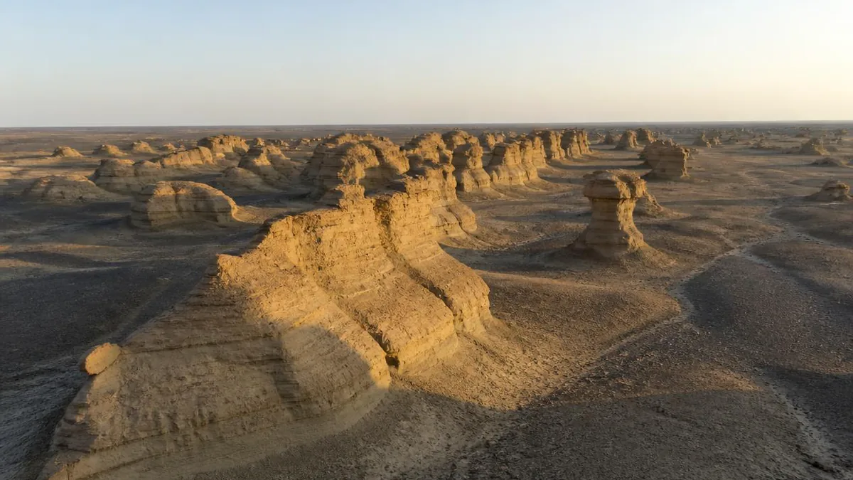
Xinjiang · Junggar Basin
World Devil City: The Wind Is Only the Chisel
Xinjiang's most famous yardang field, where a Cretaceous lake laid down the stone, a one-directional wind carved it, and the sound it makes gave the place its name.
5A View location, maps and nearby scenic areasEverything written about this place credits the wind. The name comes from wind. The alternative name, Urho Wind City, is literally wind. The photographs are captioned wind-carved, and the guides will tell you the wind did it.
That is half true, and the missing half is better. The wind here is only the chisel. What decides the shape of every ridge, mushroom and wall in front of you is a lake that dried out long before there was anyone to name it—and the layers that lake left, hard on soft, are the reason the wind cut castles instead of a flat plain.
The word came from a guide, not a geologist
Start with the label, because it is unusually honest about its own origins.
Yardang is a Turkic word, generally glossed as steep bank or steep hillock, from a root yar. It entered scientific English through the Swedish explorer Sven Hedin, who encountered ridged, wind-shaped clay terraces in a dried river bed near Lop Nur and published the term in 1903—the OED reportedly dates its first English appearance to 1904, which is the sort of one-year discrepancy worth noticing rather than smoothing over.
Hedin did not invent the word. He asked, and wrote down what he was told. Chinese science took the same word back in transcription as yadan, which is how a Uyghur description of a small steep hill became the international name for a landform now mapped on Mars.
Older observation exists too. Han-dynasty texts describe the White Dragon Dunes, plausibly yardangs, and the geographer Li Daoyuan explained the Lop Nur forms as water-cut first and wind-shaped afterwards roughly fifteen centuries ago. That sequence—water, then wind—is exactly the modern reading, and it is the key to everything here.
What the wind is actually cutting
The rock under your boots is a lake floor.
Accounts converge on the outline: in the Cretaceous, this was a large freshwater lake with vegetated shores. Crustal movement and uplift drained it and turned the basin into what Chinese geology calls a Gobi platform—a terrestrial expanse of interbedded sandstone and mudstone. Ignore the tourism pages that reach for “billions of years.” The relevant beds here belong to the Early Cretaceous Tugulu Group, measured at this locality at roughly 581 to 877 metres thick, dominated by mudstone, with siltstone, sandstone and gypsum interbeds.
Then the climate dried. Uplift through the late Pleistocene exposed those flat-lying lake beds at the surface, and the erosion that made the “city” is a Holocene process—the last twelve thousand years or so, by the usual account.
Hold the numbers loosely and the sequence tightly. A lake deposits fine mud in still water and coarse sand when inflow is strong, so its floor is a stack of alternating hard and soft sheets. The wind did not build that stack. It only found it, and the stack decided what the wind could do.
Read one mound from the top down
This is the section to put into practice on site. Pick a single isolated mound and read it from the cap to the base.
The cap is why it still exists. Wind and running water strip loose sandy layers readily, but dense mudstone and gypsum-cemented beds resist. Wherever a hard bed survives as a lid, the softer material beneath it is sheltered and the whole column persists as a ridge or tower. Where the lid has gone, the column is already a groove.
The waist tells you about temperature. Even hard mudstone is not impregnable: sharp desert temperature swings expand and contract it until it cracks. Once a crack opens, the softer sand below is exposed and stripped, and the mound loses its protection from the inside.
The base explains the mushrooms. Sand-laden wind carries its load close to the ground, so abrasion is fiercest in the lowest metre or two. That is why so many isolated rocks here are broader on top than at the bottom, and why you will find hollows drilled into vertical faces—wind-erosion niches, often compared to grotto alcoves.
One more shape check: a classic yardang is at least three times longer than it is wide, hull-shaped from above, and a field of them is called a fleet. If the mound in front of you reads as a boat, you are looking at the wind’s fingerprint. If it reads as a layer cake, you are looking at the lake’s.
Why they all point the same way
Yardangs require a strong, essentially one-directional wind, and this site has one.
Karamay’s prevailing wind is northwest. Analysis of a long observation record at the Karamay district station—covering 1971 to 2012—found that on days with extreme gusts above 20 m/s, northwest accounted for about 59 percent of directions and west-northwest another 25 percent; four adjacent directions together exceeded 98 percent. That is about as uni-directional as real weather gets.
Now compare that with the official description of the landform: the field trends northwest and east–west, more than 5 kilometres across in both directions, roughly 10 square kilometres in area, at about 350 metres elevation. Ridges elongated along the dominant wind is the textbook result, and here you can check it yourself with a compass rather than taking it on faith.
The wind supply has a geography. This is the northwestern rim of the Junggar Basin, between the Altai and the Tianshan, downwind of some of Xinjiang’s most notorious wind gaps, and part of the local gale regime comes over the Jair range as a downslope wind on the lee side. The number you will see quoted for gale days at Karamay ranges from about 47 to 71 days a year depending on the period and station used. Treat the spread as honest measurement, not sloppiness.
The name, the legend, and the physics
Two paragraphs, in that order, and they do not contradict each other.
The legend first. Travellers, herders and caravans crossing this ground at night reported voices—wailing, shrieking, something moving among the stones. Local Mongolian and Uyghur names, transcribed Sulumuhake and Shayitankeerxi, both mean devil city, and the Chinese moguicheng is the same idea. Nobody in the historical record was being fanciful for effect. They heard something, repeatedly, and named the place after it.
Now the physics, which is more interesting than a ghost. The site is a wind gap where gales are frequent; local sources put the maximum at force 10 to 12. The eroded mounds are pierced, cracked and slotted—precisely the geometry that turns moving air into sound. Airflow forced through gaps and cavities separates, sheds vortices and resonates, and a field of thousands of such openings behaves as a very large, very rough instrument. The stronger the wind, the louder it gets. That is why the alternative name, Wind City, is the descriptive one, and Devil City is the reaction to it.
Which leaves you a decision on site: come on a calm evening for the photographs, or come on a windy one for the reason it is called what it is called. You will not get both.
The lake left more than layers
The same beds that shape the skyline hold the animals that lived beside the water, and their discovery story runs through the oil industry.
In 1963, a geologist in the palaeontological division of the Xinjiang petroleum bureau collected the first vertebrate fossils near Wuerho. The material went to Beijing, and in 1964 the palaeontologist C.C. Young named Dsungaripterus weii—the species name honouring the collector—one of China’s earliest described pterosaurs, with a wingspan estimated at about 3 to 3.5 metres and an upturned, toothless beak tip apparently sheathed in keratin, with blunt teeth behind it for crushing.
From the same neighbourhood came Wuerhosaurus homheni, a plated stegosaur notable for surviving into the Cretaceous when most of its group had already gone, and Kelmayisaurus petrolicus, a large predatory theropod. Read that second name twice. The genus honours Karamay—Uyghur for black oil—and the species epithet honours petroleum. Both were named by Dong Zhiming in 1973, in a paper titled simply “Dinosaurs from Wuerho.”
Recent uranium-lead zircon dating places this assemblage at roughly 134 to 135 million years, in the middle Valanginian, making it one of the earliest Cretaceous pterosaur faunas known anywhere. When a signboard says Cretaceous lake, that is the lake.
The footprints you probably cannot visit
There is a second, quieter site nearby that deserves mention precisely because it is not a stop on the circuit.
At the Huangyangquan Reservoir, described as about 15 kilometres northwest of Wuerhe District, a 2021 study catalogued more than 1,500 tracks across a handful of small localities. The composition is unusual: birds about 41 percent, turtles 23 percent, pterosaurs 18 percent, non-avian theropods 15 percent, and stegosaur tracks—assigned to Deltapodus curriei and plausibly made by Wuerhosaurus—only about 3 percent. Some pterosaur traces are not walking prints at all but parallel scratches read as swimming or rowing.
The palaeoenvironment reconstruction is what connects it to the ridges you came for. Mud cracks are widespread on the track surfaces, which means the sediment was repeatedly exposed above water: these are shoreline mudflats, wetting and drying in cycles, with grain-size rhythms recording the lake deepening and shallowing and its colours reddening as the climate dried.
Access is another matter. The track localities sit under reservoir management with protective fencing, and Xinjiang’s natural resources authority describes the fossil site as currently undeveloped, a candidate for future education use. Assume you are reading about it rather than standing on it, and confirm before planning a visit.
Oil and fossils out of the same rock
Karamay is the only city in the world named after oil, and the naming is literal: black oil, after a group of natural asphalt hills where crude has seeped to the surface and hardened for a very long time.
The industrial history is precise. Drilling began at the Heiyoushan No. 1 well in July 1955, and on 29 October 1955 it produced industrial oil—the discovery well of the Karamay field, and the first major oilfield found in China after 1949. Annual output passed ten million tonnes in 2002.
This is not a digression from the geology. A thick lacustrine mudstone sequence is exactly what generates and seals hydrocarbons, which is why the same rock unit produced both the oilfield and the pterosaurs, and why petroleum geologists were the ones who found the bones. Within and beside the scenic area you can see the shallow end of that system: a natural asphalt deposit on rising ground to the west, described in Chinese sources as left essentially untouched until 1957, plus oil-industry relics among the shuttle stops.
Look for the pumping units on the horizon as you approach. The derricks and the yardangs are reading from the same page of the same book.
Plan around light and wind, not distance
Practical structure first, then the caveats, because almost every specific here changes.
Access inside the core is normally by the scenic area’s sightseeing train rather than on foot; descriptions give the circuit as roughly 10 to 13 kilometres with about two hours for a full loop, stopping at named points including film locations and a Dinosaur Valley. Nine named canyons—Lovers’ Valley, Snake Valley, Broken Bridge Valley and others—make up the main developed zone. The place is a long-standing film set; Crouching Tiger, Hidden Dragon is the title most often attached to it.
Timing is the one decision that matters. Midday sun comes from above and erases the relief that makes these forms legible; photographers consistently recommend the last ninety minutes before dark, when low light rakes across the ridges and each one throws a shadow. Sunrise works for the same reason. May to October is the usual season.
Then the honest warnings. There is effectively no shade, and the district holds an extreme maximum above 46°C, recorded in 2004 at a station within Wuerhe District. Annual precipitation at Karamay runs around 109 millimetres against evaporation of roughly 2,690—about twenty-five times as much. Blown sand is routine, so eye protection and a scarf earn their place. Whether you may walk in given sections, whether drones are permitted, ticket and train prices, night-lighting programmes and opening hours all differ between sources and seasons. Check at the gate.
Stand still and let the wind finish the sentence
Before you get back on the train, stop somewhere with a wall of layered rock in front of you and give it two minutes without a camera.
You are standing on the floor of a lake, at the level the wind has reached so far. Above your head, the beds continue in the mounds; below your feet, they continue down for hundreds of metres. Somewhere in that stack are the surfaces a pterosaur landed on and a stegosaur crossed, and slightly deeper is the mudstone that eventually made a city out of oil.
The wind is still working. Sand is moving past your ankles right now, exactly where it does the most damage, and the mound beside you will be a slightly different shape in a century. That is the thing to take away from Devil City: not that the wind made this, but that the wind is only editing it—and the manuscript was written in still water, by a lake that no longer exists.
The LoreLens app can help you identify yardang forms, wind-erosion niches and layered lakebed sequences while explaining the geology around them.
Location profile
Where it is

Frequently asked questions
Why is it called Devil City?
For the sound, not the shape. The site sits in a wind gap where gales are routine, and published descriptions attribute the name to the noise air makes moving through cracks, hollows and narrow gaps between the eroded mounds. Local Mongolian and Uyghur names for the place, transcribed as Sulumuhake and Shayitankeerxi, are both glossed as devil city. Chinese sources also call it Urho Wind City, which is the more literal label: the wind arrived first and the name followed.
What is a yardang, and is Devil City one?
Yes—it is one of China's best-known yardang fields. A yardang is a streamlined ridge cut from consolidated or semi-consolidated material by wind abrasion and deflation, typically three or more times longer than wide, aligned with a strong one-directional wind. The word is Turkic, roughly steep bank, and entered English through Sven Hedin's Lop Nur work published in 1903. Chinese renders it yadan. Devil City is the colloquial name; yardang is the landform class.
Were dinosaurs really found here?
Yes, and by oil geologists. The rocks exposed at Urho belong to the Early Cretaceous Tugulu Group, and vertebrate fossils collected near Wuerho from 1963 onwards produced the pterosaur Dsungaripterus weii, named in 1964, and the late-surviving stegosaur Wuerhosaurus homheni. A theropod from the same beds was named Kelmayisaurus petrolicus after the oil city and the industry that found it. Recent uranium-lead dating places this fauna at roughly 134 to 135 million years.
When should I go, and can I walk?
May to October is the usual window, and late afternoon into dusk is when the ridges gain shadow—midday flattens them. There is effectively no shade, the district recorded an extreme high above 46°C in 2004, and blown sand is common, so bring water, sun cover and eye protection. Access inside the core is normally by the scenic area's sightseeing train rather than on foot, and route length, stops, walking permission and drone rules all vary between sources and seasons—confirm at the gate.
Sources and further reading
Background references for the history and place names in this guide. Opening hours, ticketing and access change often — always confirm with official local information before travelling.