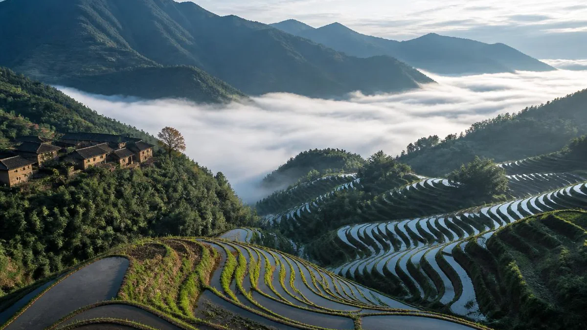
Zhejiang · Lishui
Yunhe Terraces: Seven Hundred Tiers and a County Built to Police a Mine
A National Wetland Park with no lake in it, 1,200 metres of vertical drop between its lowest paddy and its highest, and a county that exists at all because in the 1440s several thousand illegal silver miners went into these mountains and did not come out quietly. The terraces are older than the county. Nobody can say by how much.
5A View location, maps and nearby scenic areasStart with the fact that sounds like a filing error.
The Yunhe Terraces are a National Wetland Park. There is no lake in them. There is no marsh in the sense that the word usually carries, no boardwalk over standing water, no reed bed at sea level. The site sits on a mountainside in the southwest corner of Zhejiang, and its lowest paddy and its highest are separated by about 1,200 metres of vertical drop. To reach the wetland you climb.
The classification is not a bureaucratic stretch. Just over 875 hectares of the park is registered wetland, and the great bulk of that is flooded rice terrace — human-made wetland, the same category that covers fish ponds and reservoirs. The park’s own description lists four types inside its boundary: artificial terrace wetland, high-altitude boggy meadow, forested swamp and river. This is the headwater country of the Fuyun Creek, a tributary of the Ou River, the river that drains most of southern Zhejiang, and the water leaving the bottom of the system is recorded as meeting China’s Class I surface water standard — the top band.
So: a wetland that is a staircase, and a staircase that is a working farm.
The other thing worth knowing before you go is that the county the terraces sit in is younger than the terraces, and was created specifically because of trouble in these mountains. That story involves silver.
What the 5A rating covers, and where it stops
A great many Chinese 5A designations are containers — one rating stretched over several sites an hour apart, sold on one ticket, sharing nothing but an administrative boundary. Yunhe is not one of those, and that makes trip planning unusually simple.
Everything is inside Chongtou, one township in the southwest of Yunhe County, about 9.5 kilometres from the county seat. Chongtou covers 221.9 square kilometres of mountain; the terrace system inside it is usually given as about 50 square kilometres, with a core area of a little over 20. The local description divides the terraces into five blocks — Nanshan, Wuping, Xiayang, Yeyang and Meizhu — and puts the altitude range at 200 to 1,400 metres.
The number everyone quotes is the number of tiers. Most sources say more than 700; the entry that deals specifically with the Meiyuan terraces says 600 to 700. Either way it is described as the largest terrace group in East China, which is a regional rather than a national claim and is worth reading as such: the Hani terraces in Yunnan and the Longji terraces in Guangxi are both larger and both better known abroad.
Three separate designations overlap here with three separate boundaries, and this is the main source of confusion in anything written about the place:
- The scenic area, which is the 50-square-kilometre figure and the thing the 5A plaque is attached to.
- The Zhejiang Yunhe Terraces National Wetland Park, a smaller and more precisely drawn polygon covering all or part of ten administrative villages plus a block of the county forest farm. Its total area is given as 2,192.4 hectares in one official summary and 2,354.67 hectares in another. Vertical relief inside the park is put at 500 metres, not 1,200 — a useful sign that it does not cover the whole hillside.
- The Yunhe Terraces Agricultural System, a heritage listing under the agriculture ministry rather than the tourism ministry, with its own mapped area.
Nobody reconciles these. Any given article will pick one set of numbers and present it as the description of the place.
What is not in it
The county has other attractions and none of them are on this ticket.
Xiangong Lake, also written Yunhe Lake, is a separate scenic area rated 4A, covering about 16 square kilometres around the Jinshuitan reservoir in a different township roughly ten kilometres from the county seat in the other direction. It is sold on hydropower interpretation, fishing, boat trips and a resort. It has nothing to do with the terraces and is not inside them. The Xiaoshun area and the Huangjiashe cool-summer area are likewise separate.
Then there is a set of sites inside Chongtou township that may or may not fall inside the scenic-area gate depending on which map you are reading: Wudai Peak, the rock formation called Sengni Yan, the valley known as Baiyin Gu — Silver Valley — and the silver mine remains. The mine remains matter for the story told below and are listed in official descriptions of the township. Whether a standard terrace ticket gets you to them is a question for the visitor centre on the day, and the honest answer here is that I could not establish it from published sources.
Finally, and most confusingly for anyone reading a map: the county immediately to the south is Jingning, the only She autonomous county in China. Jingning is not Yunhe. The two were the same administrative unit between 1962 and 1984 and were separated by State Council approval on 30 June 1984. A lot of writing about She culture in this corner of Zhejiang slides between them.
A county invented because of a mine
In 1442, according to the county’s own historical summary, a group led by Ye Zongliu — along with men named Wang Neng, Zheng Xiangsi, Cang Datou and Chen Gongshan — went into the mountains of Yunhe and Longquan with something over a thousand followers to dig silver. Ye Zongliu was from Qingyuan, in what is now the southern part of Longquan city, a few valleys west of the terraces.
Illegal mining in the Zhejiang–Fujian border ranges was a chronic Ming problem: the state ran silver as a monopoly, opened and closed official smelters according to court politics, and left behind both the ore and a population who knew how to get at it. In this case the miners became an army. The dates do not quite agree — Ye Zongliu’s own biographical entry puts the rising in the seventh month of 1444, while the Yunhe county history dates it to 1445. He styled himself Great King, made common cause with Deng Maoqi’s rebellion in Fujian, and split his force into two columns, one against Pucheng in Fujian and one against the Chepan pass on the Jiangxi border.
He was killed in the eleventh month of 1448, and the sources disagree about how. The Mingshi Jishi Benmo has him defeated on the Fujian–Jiangxi border by a commander named Dai Li and struck down by a stray arrow. The History of the Ming says he was killed by his own ally Chen Jianhu.
The court’s answer to all this was administrative. Sun Yuanzhen (1388–1474) — a jinshi of 1415 from Jiangxi, sent to Zhejiang as provincial administration commissioner in 1443 and left there to clean up — argued that the problem was that the mountains were too far from any county seat to govern. In 1452 he petitioned to carve new counties out of the existing ones. Yunhe was cut from two townships of Lishui county, Fuyun and Yuanhe, and its name is simply the last character of each. In the same petition he asked for Jingning, cut from Qingtian county, on the stated grounds that the valleys were remote and dangerous and the miners were gathering in riot; and for Xuanping, and for Taishun out of Rui’an.
There is a small discrepancy in his title. The Yunhe account calls him Minister of War at the time of the petition; the Jingning account calls him Vice Minister of the Left. His biography resolves it: he was promoted to Minister of War in the sixth month of 1452, so both are probably right, a few months apart.
The point for a visitor is this. You are standing in a landscape whose administrative existence was created as a policing measure against the people already farming it. The terraces were here first. The county came to keep an eye on them.
Who cut the first tier
The received chronology, repeated in every Chinese account, runs: first opened under the Tang, flourishing under the Yuan and the Ming. No source I can find attaches a document, an excavation or a dated inscription to the Tang claim, and it should be read as tradition rather than evidence.
The Ming part is more specific and more interesting. From the Hongwu reign (1368–1398), Yunhe was an important imperial silver district, and the accounts state that the mining workforce took part in clearing terraces — that the large-scale expansion of terraced rice here is bound up with silver extraction and smelting. That is a claim about correlation with a plausible mechanism behind it: a mining district needs to feed several thousand men in a place with, in the county’s own phrase, nine parts mountain, half a part water and half a part field. You cannot ship grain up these valleys cheaply. You grow it on the slope or you do not eat.
The third phase is late Ming and early Qing, when She households moved into these mountains in quantity and terrace farming reached the scale you see now. It is the She arrival, more than anything else, that the local sources credit with turning scattered paddy into a system.
The people whose name means burnt field
The She are one of China’s smaller recognised minorities: 708,651 people at the 2010 census, about 746,000 by the 2020 count. Roughly nine in ten live in Fujian and Zhejiang, and the She are the largest minority in both provinces. They call themselves shan ha — mountain guests. They have no script, and the great majority speak a Hakka-adjacent variety rather than the Hmong-Mien language that linguists call She proper, which survives among only a few thousand speakers in Guangdong. Most trace their origin to Phoenix Mountain in Chaozhou. The four clan surnames are Pan, Lan, Lei and Zhong, and Pan has largely vanished from the population.
The written name is the joke. The character she — 畲 — is old and it means a newly cleared field; read one way it denotes the slash-and-burn cycle, cutting and firing a patch of hillside, cropping it and moving on. It became an ethnonym in the Southern Song precisely because that was how outsiders described the way these people farmed. A gazetteer of Longquan, the county next door to Yunhe, put it flatly: they are named she because they are good at that kind of field.
Terracing is the exact opposite of shifting cultivation. It is the technology of never moving again: you cut a bench, you wall it, you level it, you flood it, and then you and your descendants maintain it for four hundred years. Somewhere in the seventeenth century, in these valleys, a people named for burning their fields committed to a landscape that cannot be abandoned without collapsing.
They are still here, in modest numbers. Chongtou township counted 24,312 people in 2011, of whom 2,148 belonged to eighteen minority groups — 1,784 of them She, a little over seven per cent of the township. Yunhe County has two designated She townships, Wuxi and Anxi, and the only She autonomous county in the country begins at its southern boundary.
Grain in Ear
The ninth of China’s twenty-four solar terms is Mangzhong, usually translated Grain in Ear, and it falls around 5 to 7 June. It is the hinge of the farming year in the rice south: the awned crops ripen and must be got in, and the rice must go into the ground, both at once. The twenty-four terms were inscribed on UNESCO’s Representative List of Intangible Cultural Heritage in 2016.
At Meiyuan, in these terraces, Grain in Ear is when the ploughing starts, and the day carries a rite the locals also call the Ox King Festival.
The catchment is eighteen villages, centred on Meizhu and Xiayang. The organisation runs through twelve niu — host villages that take turns managing the affair. The sequence, as set out in the heritage documentation:
- Setting the niu and welcoming the gods. On an auspicious day before Grain in Ear the host villages send a party to bring the blessing deities to the Temple of Yu the Great at Meizhu village. Yu the Great is the mythic engineer who tamed China’s floods by dredging instead of damming — the patron, in other words, of moving water where you want it, which in a terrace system is the entire problem.
- The procession. It sets off from Wushan village and works through all eighteen settlements.
- The ploughing itself. On the day, everybody converges on the terraces at Xiayang. An altar is laid. A chief celebrant, a Daoist priest and the clansmen of the eighteen villages perform the sequence in order: sounding the reed horn, roaring the mountain-opening chant, the offering to the sacred field, the rewarding of the ox, the first furrow, and the dividing of the red meat. The Shapu mountain songs and She mountain songs are sung.
- The opera. A stage at Xiayang, local flower-drum opera among other things.
- The fairy-maiden meal, eaten by the Xiayang clansmen that evening, which closes the festival.
The rewarding of the ox is the part that tells you what kind of rite this is. Before the animal does the year’s heaviest work it is fed, decorated and thanked. In a landscape where a full-sized tractor cannot turn around on a two-metre-wide bench, the ox is not sentiment. It is the machine.
How old the ploughing festival is, honestly
The dating rests on one line and an inference from it.
The Tongzhi-era Yunhe County Gazetteer, compiled in the mid-nineteenth century, says in its fifteenth chapter that the county has a practice of welcoming the gods, and that it is of long standing. That is all it says. From this the heritage documentation concludes that the welcoming and the offering to the sacred field were being handed down no later than the Hongzhi reign (1488–1505), and the round figure that gets quoted is over five hundred years. The festival in its full form is dated to the late Ming and early Qing — the same window as the She arrival.
Then it stopped. The accounts say the custom declined after 1949 and revived after Reform and Opening, which is the same twenty-to-thirty-year gap that swallowed most Chinese village ritual in the twentieth century, stated here without elaboration.
The modern run begins in the mid-2000s, when the county picked the festival up as a cultural brand. One account dates that to 2006; the edition staged on 5 June 2026 was billed as the twentieth, which counts back to 2007. It was listed on Lishui’s municipal intangible heritage register on 17 September 2008, and in May 2021 the State Council added it to the fifth national batch as an extension entry under the twenty-four solar terms — project number X-68, category folk custom. The local boast is that this filled the Grain in Ear gap in the national list, Grain in Ear having had no representative custom on it before.
So: an inherited sequence, a documented lapse, a state-sponsored revival, and now a photography event that draws thousands. All four are true at once, and the sources say so.
Abandonment, and the putting-back
The uncomfortable middle of this story is what happened to the terraces themselves in the last few decades, and the Chinese accounts are unusually direct about it.
Terrace benches are small. They are the wrong shape for machinery, they cannot be consolidated without destroying the thing that makes them work, and the labour they need left for the coastal factories. The result was a high rate of abandonment — fields going out of cultivation and, once out, degrading fast, because an unmaintained terrace wall is a landslide waiting for a wet June.
Since the 2000s the county has run land transfer and reclamation: bringing in outside operators to take on blocks of terrace, restore the bunds and put grain back in. The published totals do not agree — one summary says more than 5,000 mu of terrace ecologically restored, another says more than 4,500 — but they are the same order of magnitude, roughly three square kilometres of hillside brought back. Alongside it: thirty thousand ornamental trees planted, rice-and-fish co-culture in the flooded paddies, and, by one 2024 account, 175 guesthouses operating inside the wetland park’s villages.
Fauna monitoring reports the yellow-bellied tragopan, a first-class nationally protected pheasant, inside the park. County-wide, Yunhe records 247 bird species, 1,136 vascular plants and 20 mammals.
The point to hold onto is that this is not a preserved landscape. It is a maintained one, and the maintenance is recent, deliberate, and paid for partly by the people photographing it.
What you are actually looking at
The terraces are sold on cloud.
Yunhe sits in the wet, misty uplands of southwest Zhejiang — Lishui prefecture calls itself China’s home of photography, and the terraces are one of its ten designated photography bases. The set of conditions that draws people is the sea of clouds: cold air pooling in the valley below the terraces overnight, the top of the cloud layer sitting somewhere around the middle of the staircase, and the upper tiers standing clear in early light. In deep winter you can add rime ice on the ridge trees. Neither is scheduled, and any operator who tells you otherwise is selling weather.
Two named features come up in every account. Qixingdun — the Seven Stars mound — is the principal viewing point over the upper terraces. Kengen, one of the ten villages inside the wetland park, is an old stone-built settlement down among the paddies and is usually the walking destination rather than the viewpoint. Beyond those, the site is a road, a shuttle and a set of platforms, and the interest is in the geometry.
The seasonal cycle here is single-crop, which is worth understanding because it is what makes the calendar different from the terraces further south. At this altitude you get one rice harvest, not two. Water goes on around Grain in Ear, which is why the flooded-mirror photographs are all taken in the first fortnight of June. The green phase runs through high summer. The gold comes late, in September and October. Then the water is drawn down and the empty benches sit under frost, which is the season the local photographers prefer and the tourists mostly skip.
The paperwork ladder
Chinese scenic areas accumulate designations, and the sequence here is worth setting out because it shows the terraces being recognised by four different ministries for four different reasons.
- 2011 — rated a national 4A scenic area. The creation project at that stage was planned at 22 square kilometres.
- 2011 — designated a provincial wetland park by Zhejiang.
- 16 December 2014 — approved by the State Forestry Administration to begin pilot construction as a national wetland park, in a batch of 140 sites.
- 10 October 2015 — the Yunhe Terraces Agricultural System listed by the Ministry of Agriculture in the third batch of China’s Nationally Important Agricultural Heritage Systems, one of 23 that year and one of two from Zhejiang. Note: several summaries, including the Chinese Wikipedia article, date this to 2017 while still calling it the third batch. The ministry’s own notice is dated 2015, and the third-batch list has Yunhe on it. The 2017 date appears to be an error propagated from somewhere.
- May 2021 — the Grain in Ear ploughing festival added to the fifth national intangible heritage batch.
- 25 December 2019 — the wetland park passes its acceptance inspection and is formally entered on the national register.
- 2020 — passes the landscape quality review and enters the candidate list for 5A.
- 6 February 2024 — confirmed as a national 5A scenic area by the Ministry of Culture and Tourism.
Two marketing claims travel with all this and should be handled with tongs. The first is that Yunhe is China’s most beautiful terraces, which is a slogan and not an award. The second is that CNN named it one of the forty most beautiful places in China; the county government repeats this, and I have not been able to verify the original listing, so treat it as an unverified attribution rather than a fact.
The county around the terraces
You will almost certainly stay in the county seat, and it is a stranger place than it looks.
Yunhe County covers 989.6 square kilometres and had about 126,000 residents at the end of 2025 — small, mountainous, and the source of the nine parts mountain line quoted earlier. Its economy is not what the setting suggests. In 2003 it was formally designated China’s Wooden Toy City by the China Light Industry Federation, and the county government’s claim is that Yunhe accounts for 66 per cent of China’s wooden toy output and 40 per cent of the world’s. That figure comes from the county and is repeated everywhere; take it as a self-report. But the industry is real and visible, and the county’s chosen slogan for itself — a landscape home, a fairy-tale world — is an attempt to sell the toys and the terraces in one breath.
The other local product is the Yunhe snow pear. Tradition dates its arrival to 1450, two years before the county existed, brought in by a Fujian trader as cuttings of what the story calls an immortal fruit. The late-Qing county gazetteer records it under an older name; a specialist later fixed the cultivar name from the star-shaped russeting on the skin. The fruit is enormous — typically 800 to 1,250 grams, with a record specimen at 2.2 kilograms — and it received a national geographical indication in 2016. County plantings ran to about 1,900 hectares in 2024. The picking festival is in July, between the green phase and the gold on the terraces, and if your dates land there it is the obvious half-day.
Visiting
Yunhe is about 52 kilometres from central Lishui, and the terraces are about 10 kilometres from the county seat, up. The practical shape of a trip is one night minimum, because the two things worth being here for — the cloud sea and the low light on the benches — both happen at dawn.
If you are coming for the ploughing festival, be specific about the date: Grain in Ear moves within 5–7 June, the festival is pinned to it, and in recent years the county has strung it into a multi-week programme rather than a single morning. That is convenient and it is also a dilution; the ritual sequence itself still happens once, in the morning, at Xiayang.
If you are coming for the landscape, the honest brief is that this is a large, well-engineered, single-theme site. There is one thing to see, seen from several heights. It rewards weather and punishes a tight schedule. Guesthouses inside the wetland park villages put you above the cloud line rather than under it, which is the whole game.
And two facts to hold at once, as usual.
The first is that a good deal of what you photograph was out of cultivation twenty years ago and has been restored under a public programme, that the festival lapsed within living memory and was rebuilt as a county brand, that the tier count and the hectare count change depending on which official document you open, and that the site’s most-quoted international endorsement is one I could not verify.
The second is that the benches are real, the walls are real, the water still comes down through them in the order somebody worked out several centuries ago, and on one morning in early June a Daoist priest and the clansmen of eighteen villages still feed an ox before it goes to work. Those two things are not in tension. They are what a living agricultural landscape looks like when it survives into a century that has no economic use for it.
The LoreLens app can identify the terrace blocks, the ritual objects at the Grain in Ear ploughing and the wetland species at Yunhe, and explain what each stage of the rite is for, in your own language, offline.
Location profile
Where it is

Frequently asked questions
What does the Yunhe Terraces 5A area actually include?
Unusually for a Chinese 5A, it is one contiguous block rather than a bundle of scattered sites. Everything is inside Chongtou, a single township in the southwest of Yunhe County, about 10 kilometres from the county seat. The terrace system runs to roughly 50 square kilometres with a core of a bit over 20, divided into five named blocks - Nanshan, Wuping, Xiayang, Yeyang and Meizhu. What is not inside it: the Xiangong Lake area at Jinshuitan, which is a separate 4A scenic area of 16 square kilometres on the far side of the county, and the Xiaoshun and Huangjiashe areas.
When should I go?
There are four distinct products and they are not equally reliable. Around Grain in Ear, in the first week of June, the terraces are flooded and mirrored and the ploughing festival runs - this is the single busiest and most photographed week of the year. High summer is solid green. Harvest at this altitude is a single crop, so the gold comes late, roughly September into October. Winter brings rime ice and the best odds on a cloud sea. The cloud sea is weather, not a scheduled event, and no operator can promise it.
Is the ploughing festival old, or was it invented for tourists?
Both things are true and the sources are open about it. The rite of welcoming the gods and making offerings to the sacred field is documented in the Tongzhi-era county gazetteer, which records only that the custom is long-standing, and local accounts push it back to the Hongzhi reign of the late fifteenth century. It then lapsed after 1949 and was revived after Reform and Opening. The organised annual event dates from the mid-2000s: the edition held on 5 June 2026 was billed as the twentieth. The nine-village procession, the ox-rewarding and the shared meal are inherited. The stage, the sponsors and the photography platforms are not.
Did silver miners really build the terraces?
The claim in the Chinese sources is narrower than it sounds. They say that from the Hongwu reign onward, when Yunhe became a significant imperial silver district, the mining workforce also took part in clearing terraces, and that the large-scale expansion of terraced rice under the Ming is connected to the mining and smelting economy. That is a plausible link rather than a documented one, and nobody claims the miners started from nothing - the received chronology has the first terraces cut under the Tang. What is documented is the reverse direction: the mining unrest of the 1440s is the reason the county was created in 1452.
Is it a wetland park or a scenic area, and why does the paperwork disagree?
It is both, plus a designated agricultural heritage system, and the three have different boundaries and different published areas. The national wetland park was approved for pilot status in December 2014 and confirmed in December 2019; its area is given as 2,192.4 hectares in one official summary and 2,354.67 in another, with 875.3 hectares of that classified as wetland. The scenic area is the 50-square-kilometre figure. The Yunhe Terraces Agricultural System was listed by the Ministry of Agriculture in a separate programme in 2015. Expect any two documents to give you two numbers.