Xinjiang · Bortala
Sayram Lake: The Atlantic's Last Teardrop, Taken Literally
A fault-block lake at the windward end of the westerlies, brackish water that held no fish for its entire history, and the pass that made a mountain lake part of the Silk Road.
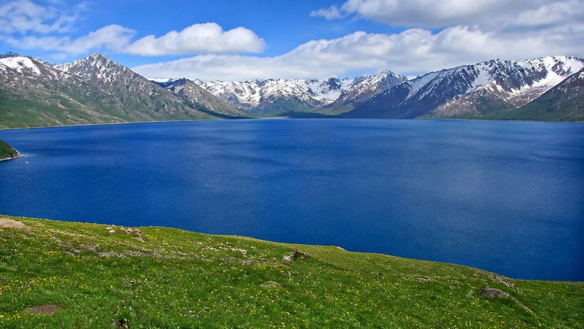
5A View location, maps and nearby scenic areasTwo facts about Sayram Lake sit awkwardly together. It is routinely described as the largest and highest alpine lake in Xinjiang, about 458 square kilometres of exceptionally clear water at roughly 2,070 metres, in the Bortala Mongol Autonomous Prefecture west of Bole. And until the very end of the twentieth century it contained no fish. Not depleted, not overfished—none, ever, in its entire existence.
Both facts come from the same cause. This lake is closed. Nothing flows out of it, and nothing of any size flows in. Everything distinctive here—the colour, the nickname, the empty water, the fact that a mountain basin ended up on a trade route—follows from that.
Nobody knows who called it the Atlantic’s last teardrop
The nickname is everywhere in Chinese coverage: Xinhua, the regional government, a China Central Television food programme. What no source provides is an origin. There is no traceable coiner, no founding documentary, no first publication. It is a media convention that stuck.
The content behind it, though, is real meteorology. A China Meteorological Administration explainer quotes Yao Junqiang, deputy director of the Institute of Desert Meteorology in Ürümqi: the lake sits on the windward slope at the western end of the northern Tian Shan, inside the mid-latitude westerly belt, and moisture that began over the Atlantic—topped up by lakes and seas along the way—is finally forced upward here into abundant precipitation. The same explainer notes the lake has no inflowing river from outside and its water reaches no ocean.
Two corrections worth carrying. First, this is not a boundary: Atlantic-derived moisture reaches well east of here. The honest reading is “the last place that air mass generously favours,” which is how careful Chinese sources phrase it. Second, there is a separate local legend about a Kazakh couple whose tears formed the lake. It is frequently spliced onto the meteorological story as if it were the same claim. It is not.
How the water actually gets over the mountains
The mechanism is worth understanding because it explains the contrast you will see from the road: a wet island in one of the driest quarters of Asia.
Westerly airflow at around 44.5°N crosses western Europe, eastern Europe and Central Asia, losing water the whole way. By the time it reaches the Tian Shan there is very little vapour left. The range lifts what remains, it cools, it condenses, and it falls as orographic rain and snow—some directly onto the lake, most onto the slopes that drain into it.
Precipitation figures disagree, and the gap matters. One encyclopaedic account gives about 350 millimetres a year, unusually evenly spread across the seasons. Popular and travel sources say the basin rim exceeds 500 millimetres. Both are quoted confidently; neither is reconciled.
What is consistent is the hydrology. Sources count 32 inflowing streams, of which only 7 are perennial, draining a catchment of about 1,408 square kilometres. The lake’s supply coefficient—catchment area relative to lake area—is given as roughly 3.1, described as the lowest of any inland lake basin in northwest China. In plain terms: this lake is very large compared with the land feeding it, and much of its water is thought to arrive as groundwater seepage rather than surface flow.
A rift, not a glacier
It is easy to assume any deep blue mountain lake in Xinjiang was gouged by ice. This one was not, and the difference is visible.
Sayram is a graben—a fault-subsidence lake. Chinese accounts tie its formation to the Himalayan orogeny around 70 million years ago, with a more detailed sequence: the end-Carboniferous Yinikala movement folded the Sayram–Borohoro block first, and Quaternary block faulting then dropped the basin floor. A caution for anyone reading around: some popular articles state seventy thousand years, which appears to be a copying error propagating through content farms. The geological literature says millions.
The faults left their signature. The shoreline is unusually straight and the outline roughly trapezoidal, because the lake’s edges are structural boundaries rather than shapes cut by water. And the Quaternary lake sediment stacked in the basin is a climate and glaciation archive for the western Tian Shan—the reason researchers care about a lake that fishermen ignored for centuries.
Read every number as a range
Almost nothing about this lake has a single agreed figure, and pretending otherwise would be dishonest.
Elevation appears as 2,070, 2,071.9, 2,073 and 2,074 metres. Surface area as 453, 457, 458 and about 460 square kilometres. Dimensions run about 30 kilometres east to west and 25 to 27 north to south. Mean depth is given as either 46.4 or 56 metres. Maximum depth is the worst case: 90, 92, 106 and 110 metres all appear in circulation, with the mid-lake floor described as sitting around 75 to 81 metres. Volume is quoted as either 21 billion or 26.1 billion cubic metres.
Transparency, at least, is consistent and remarkable: 10 to 12 metres.
The practical consequence of that spread is not academic. If sources cannot agree whether the water is 90 or 110 metres deep, nobody on the shore can tell you what is beneath the surface a few metres out. Swimming here is prohibited, and the ambiguity is part of why.
Brackish, freezing, and historically empty
The single most misreported thing about Sayram is its water chemistry. English-language references often file it as a freshwater lake. Chinese measurements do not support that.
The average mineralisation is 2,853 milligrams per litre—about 2.85 grams, comfortably brackish—with total hardness near 1,438 mg/L and a pH averaging 8.8 to 9.0. The chemistry is sulphate-magnesium type, with sulphate at 38.8% and magnesium at 12.7% of total ions. China’s environment ministry classifies it as a cold brackish lake.
It is not evenly salty, and the pattern is legible: about 2,768 mg/L in the northwest near the Chagan Gol, the largest inflowing stream, rising to 3,071 at the centre and 3,109 in the southeast. The one meaningful river dilutes its own corner and nothing else.
Stack that with water averaging 10 to 12°C, ice one to two metres thick from December into May, low dissolved oxygen, and thin plankton and benthos—then add the absence of any channel a fish could have swum in through. The nineteenth-century survey Xiyu Shuidao Ji recorded the result bluntly: not a blade of grass in the pool, and neither fry nor larvae produced in it. The old Chinese name for the lake was Jinghai, the “clean sea.” It was clean because it was empty.
From an empty lake to caviar exports
The attempt to change that is a genuinely instructive failure story before it is a success story.
Stocking began in 1976 with poor results. Through the 1980s, researchers released on the order of 20 million fry across a dozen-plus species—ide, roach, European perch, a Xinjiang loach among them—and watched for about ten years. Most died of cold. The survivors grew too slowly to be commercially viable. Dates in circulation conflict, with some accounts putting the first trials in 1968 or the 1970s, so treat the chronology as approximate.
The conclusion drawn was that only a true coldwater fish could work. The choice was peled (Coregonus peled), a whitefish native to the Ob basin in Siberia: extremely cold-tolerant, fast-growing, plankton-feeding, and with Soviet hatchery technique solved back in the 1950s. Eggs were imported from Russia in 1998; accounts describe incubation temperature held within 0.4°C, more than 600,000 fry hatched and roughly 560,000 surviving. The first commercial harvest came in 2000, ending a fishless history.
Sixteen species are now naturalised. A hatchery in Wenquan county reports incubating 80 million fertilised eggs a year before release, and caviar produced here has been exported as far as Finland. One recent plan cites 15 million fry released for annual output of 500 tonnes—read production figures like that as targets, not measurements.
Guozigou: why a mountain lake is on a trade route
A closed alpine basin has no business being historically important. Sayram is, because of the valley immediately south of it.
Guozigou, also called the Taleqi valley, runs about 28 kilometres through the northern Tian Shan and is named for its wild apples. It was the throat of the northern Silk Road route toward Central Asia and Europe, defensible enough to earn the nickname “iron pass.” In 1218, during Genghis Khan’s westward campaign, his second son Chagatai was ordered to cut the rock into a road and fell timber for bridges—48 bridges by one account, rebuilt as 42 under the Qianlong emperor. From Songshutou, the top of the valley, the ground drops north to the lake and south into the gorge.
The written record follows the road. The Taoist Qiu Chuji, passing through, described the lake as a “heavenly pool” some 200 li around and ringed by snowing summits. Yelü Chucai wrote about it. Lin Zexu saw it on his way into exile after the First Opium War.
The modern version of the same problem is the Guozigou Bridge, begun in August 2007 and opened in late September 2011, described as China’s first steel-truss cable-stayed bridge, with its tallest pier standing over 200 metres above the ground and a tunnel at each end. Eight hundred years apart, two answers to one valley.
The ring road, shore by shore
The circuit figure needs the same treatment as everything else. It is commonly quoted at 90 kilometres, the road completed in 2005 is documented at 79, and the shoreline is itself about 90. Approximate is the honest word.
There are three gates—east, north and south—with the south commonly exit-only, and most visitors enter at the east and then either self-drive or take the scenic-area shuttle.
The named stops each do something different. Moon Bay gives the widest frame, with a row of snow peaks behind the water. The S-bend is the road-and-lake photograph, best at sunrise. Songshutou is a walk uphill for a view over the whole lake and out toward the Guozigou Bridge. The western shore holds the flower slopes and the West Sea Grassland, with boardwalks into the trees.
One reported pattern is worth testing rather than trusting: travel accounts say flower colour differs by shore—purple in the north, yellow in the west, blue in the east. The forest above the water is Schrenk spruce, the signature tree of the Tian Shan, and surveys record 639 seed plant species around the lake.
Four seasons, unequally distributed
Grass starts moving in mid-May. From roughly late May the flowers open in sequence—wild tulips, globeflower, forget-me-not, iris—and mid-June to July is the peak, which is the image nearly every visitor arrives holding. Mid-June is frequently named the best all-round window. A Nadam gathering is held on the lakeside grassland in July.
July and August run around 15 to 25°C, with pasture at its greenest and the ring road at its easiest for cycling. September and October turn the shore gold against dark spruce and blue water, with a sharp drop in visitors.
Then the other lake. From early January to early March, the surface is walkable in designated areas, with bubble-veined blue ice along the shore, dry air and frequent sun; the northern ice is reported flatter and richer in bubbles. Freeze-up begins in December, ice reaches one to two metres, and the thaw runs into May.
One counterintuitive detail from the hydrological record: the lake’s water area is largest in April and smallest in July—the opposite of what the flower season suggests.
Cold, closed, and to be handled carefully
At 2,070 metres the weather turns fast enough that a warm layer in July is not optional. Winter days sit around −5 to 5°C and nights between −15 and −10.
Three physical cautions, all locally posted. Do not enter the water. The ring road has tight bends, a posted limit and no casual roadside stopping. The grassland can be boggy away from the road, summer thunderstorms mean getting off high ground and away from the water, and on the ice you stay inside the marked areas.
Everything commercial should be confirmed rather than assumed. Ticket and shuttle prices here are set administratively and do change—Xinjiang’s price authority reset the shuttle fare in April 2024—so check current prices, which gates are open, and which stretches are drivable at the entrance on the day, not from an itinerary written a year ago, including this one.
The last item is not a rule. Grassland degradation has been recorded around the lake since the 1980s, and in 2007 nearly 1,200 herders from valleys including Guozigou were resettled off the mountain, partly to protect the lake and the pass. The yurts along the shore in summer belong to working families, and the meadow they stand on is under active management. A closed lake has no way to flush anything out—which is the whole reason it looks the way it does, and a decent argument for leaving it exactly as you found it.
Location profile
Where it is

Frequently asked questions
Why is Sayram Lake called the last teardrop of the Atlantic?
Because of where it sits in a moisture chain, not because of a measured boundary. The lake lies on the windward slope at the western end of the northern Tian Shan, inside the mid-latitude westerly belt. Water vapour that started over the Atlantic crosses Europe and Central Asia, arrives here badly depleted, and is then forced upward by the range into heavy local precipitation—which is what fills a lake with no inflowing river of any size. A China Meteorological Administration explainer quotes Yao Junqiang of the Institute of Desert Meteorology in Ürümqi making exactly this argument. Two cautions: no source traces the phrase to a specific person or documentary, so treat it as a media nickname rather than a technical term; and Atlantic-derived moisture does reach further east than this, so the phrase means the last place that air mass generously favours, not a hard limit.
Are there fish in Sayram Lake, and why were there none before?
There are now, and there never were naturally. Four conditions stacked against fish: the lake is completely closed, with no outflowing river and no channel any fish could have arrived through; the water is brackish rather than fresh, with an average mineralisation around 2,853 mg/L of the sulphate-magnesium type and a pH near 8.8 to 9.0; water temperature averages roughly 10 to 12°C with ice one to two metres thick from December into May; and plankton and benthic food are sparse with low dissolved oxygen. A nineteenth-century Chinese geographical survey, the Xiyu Shuidao Ji, recorded that nothing at all grew or spawned in it. Stocking attempts from 1976 and through the 1980s failed. Peled (Coregonus peled), a Siberian coldwater whitefish from the Ob basin, was introduced as imported eggs in 1998 and harvested commercially from 2000; sixteen species are now established.
When is the best time to visit Sayram Lake?
It depends which lake you want. Wildflowers run from roughly late May, with wild tulips, globeflower, forget-me-not and iris opening in sequence; mid-June to July is the peak and the picture most visitors come for, and mid-June is often named the best all-round window. July and August sit around 15 to 25°C with green pasture. September and October turn the shore gold against dark spruce with far fewer people. Then blue ice: early January to early March, when the surface is walkable in designated areas and bubble-veined ice forms along the shore. Freeze-up begins in December and the thaw runs into May.
Can you drive around the lake, and can you swim in it?
You can circle it—the ring road is commonly quoted at about 90 kilometres, though the road built in 2005 is documented at 79 and the shoreline itself is roughly 90, so treat the number as approximate. There are three gates, east, north and south, with the south often exit-only; most visitors enter at the east and either self-drive or use the scenic-area shuttle. Speed is limited and casual roadside stopping is discouraged on the bends. Swimming is prohibited. Depth figures in circulation range from about 90 to 110 metres and nobody standing on the shore can tell you what is under the water in front of them, which is part of the reason for the rule. Confirm current ticket and shuttle prices, open gates and drivable sections at the entrance on the day.
Sources and further reading
Background references for the history and place names in this guide. Opening hours, ticketing and access change often — always confirm with official local information before travelling.