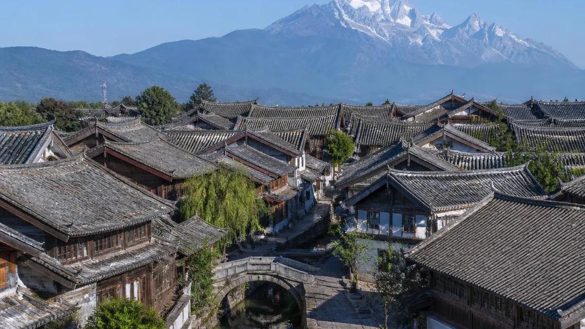
Yunnan · Lijiang
Lijiang: The Town Rebuilt Into a World Heritage Site
At 19:14 on 3 February 1996 an earthquake wrecked the Lijiang basin. What the province and the World Bank decided to rebuild, and what they decided to demolish, is the reason the old town was inscribed twenty-two months later — and the reason its water still runs.
5A View location, maps and nearby scenic areasMost Chinese towns with a wall lost it. Lijiang never had one — which is where most accounts of the place begin and end.
The more useful entry point is a date. At 19:14 on 3 February 1996 an earthquake hit the Lijiang basin. It killed 309 people, seriously injured 4,070, left more than 180,000 without homes and brought down a great deal of the old town’s walls and roofs. Twenty-two months later the old town was on the World Heritage List.
The two facts are connected, but not the way the connection is usually made. The earthquake did not earn the listing. The decisions taken while rebuilding did.
Seven fourteen in the evening
The China Earthquake Networks Center recorded the shock at magnitude Ms 7.0, with its epicentre near Daju township beside the Jinsha River in what was then Lijiang County, and a focal depth around ten kilometres. The United States Geological Survey puts it at Mw 6.6 — with Mb 6.4 and Ms 6.5 also on file — and in April 2017, twenty-one years later, assigned it a maximum intensity of X. Both magnitudes are correct within their own conventions; the Chinese surface-wave figure is the one on every local sign.
Field survey identified the causative structure as the east-margin fault of Jade Dragon Snow Mountain, a steeply east-dipping normal fault running roughly north–south. Damage was extremely uneven both inside the worst-shaken zone and beyond it. Nine counties across four prefectures were affected over some 18,720 square kilometres, with more than two hundred landslides in a 12,000-square-kilometre area, and 1,872 aftershocks of Ms 2.0 or greater by the end of February.
The casualty figures also diverge: Chinese records give 309 dead, 4,070 seriously and 12,987 lightly injured, and 185,321 people made homeless; an international disaster database gives 322 dead and 17,057 injured. Within Dayan old town, the average resident death rate was recorded at 12.5 per ten thousand, almost all from collapsing houses or walls.
A memorial stands beside the Lijiang–Mingyin road north of the city, and its dimensions are a small piece of writing in themselves: the shaft is 7.1 metres high with a circumference of 19.97 metres, and the wall behind it is 19.96 metres long and 2.3 metres high. The day of the quake, the year of the quake and the year of the listing, built into the stone.
What the reconstruction chose
Reconstruction was costed at around 482 million US dollars. This is where the story stops being about geology.
The World Bank worked with the Lijiang County Construction Bureau on household repair grants and on guidance for how to rebuild; demand pushed material prices up 30 to 50 per cent. A resident quoted in the Bank’s own case material used a 300-dollar grant to buy fired hollow-cement brick instead of sun-dried mud brick for her hundred-year-old house — every interior wall had to be replaced, the roof leaked, the timber columns had gone out of alignment, but the house was repaired rather than replaced.
Two things then followed that were not automatic. Yunnan province and the Bank put reconstruction money into traditional streets, pavements, bridges, canals and buildings — infrastructure, not monuments. And, in the words of the Bank’s Independent Evaluation Group, “high-rise apartment complexes were torn down and single family, traditional-style houses were reconstructed instead,” a choice the group credits with helping Lijiang achieve World Heritage designation.
UNESCO was involved from the first year. An international assistance grant of 40,000 US dollars was approved in 1996 for safeguarding the historic town after the earthquake — through 2007 it remained the only such request the property ever made. Inscription came at the World Heritage Committee session in early December 1997, under criteria (ii), (iv) and (v). The committee’s own authenticity statement notes that the town has kept its Ming and Qing layout, street landscape and architectural style “in spite of numerous earthquakes including a big earthquake on February 3, 1996.”
That is the accurate version. Not the earthquake made it a World Heritage Site, but the earthquake forced a rebuild, and the rebuild was done in a way that made the case.
Three parts, not one
The listing is not “Lijiang old town” in the singular. It has three components, and most visitors see one.
Dayan is the one everyone means, and it includes the Black Dragon Pond at its northern edge. Baisha lies about eight kilometres north and is older: it was the political and economic centre of the area under the Song and Yuan, before the Mu family moved their seat south to the Lion Hill site. Its houses run along a north–south axis around a terraced square with a spring led in from the north, and its religious buildings hold more than forty murals mixing Buddhist, Daoist and Naxi subjects with Bai stylistic elements. Dabaoji Palace and Liuli Hall became a national protected unit in their own right on 20 November 1996.
Shuhe, about four kilometres north-west, was a market and leatherworking town on the tea-horse routes, with a square built to the same logic as Dayan’s and the area’s largest stone arch bridge crossing it. It is separately rated 4A.
The boundaries have moved. In October 2010 the protected area of the three components was increased from 125.7 to 145.6 hectares and the buffer zones from 323.3 to 582.3 hectares; the modification was formally approved in 2012.
The water is the plan
One water system explains more of Lijiang than twenty attractions do.
The source is the Black Dragon Pond spring group at the foot of Elephant Hill, recharged through karst from a solution basin roughly twenty kilometres away, over a catchment of about 180 square kilometres, with spring discharge in the range of two to 4.4 cubic metres per second. The water runs south down the Yu River, and below Yulong Bridge divides into three: West, Middle and East. Of these, only the Middle river is natural. The West was cut in the Yuan, the East in the Qing. Inside town the three split again into countless small channels that run along walls and under doorways, and everything eventually leaves at the far side and joins the Yangkong River.
The bridge count indexes how thoroughly water dictated the plan: 354 bridges on the Yu River system by one official count, 93 per square kilometre, in timber, slab and arch, most Ming or Qing; another official source says simply “more than three hundred.” The finest is the double-arched Great Stone Bridge, a hundred metres east of Sifang Street, built under the Mu chiefs and also called Reflecting-Snow Bridge for what appears in the water beneath it.
Now the part the brochures leave out. The Black Dragon Pond has always failed occasionally — about once in twenty years from the early twentieth century to the 1980s, then roughly once in five, then most years. From 21 January 2012 it ran dry for 809 consecutive days, until 10 April 2014: the longest stoppage on record. A water system is heritage only while there is water in it.
Three eyes and a sluice gate
Two institutions turn that hydrology into daily life, and both are worth ten minutes of attention.
The first is the three-eyed well. Where springs surface inside town, the natural fall of the ground divides the outflow into three successive basins with a strict order of use: the upper eye is drinking water only, the middle is for rinsing rice and vegetables, the lower is for laundry. Yunnan’s provincial water authority describes it as a water-saving practice that became habitual behaviour rather than a rule anyone enforces — common-pool resource management, still legible on the ground.
The second is street flushing at Sifang Street. The square at the centre of Dayan is a small trapezoid of about a hundred square metres paved in the local red breccia. The West River runs slightly higher than the paving, and the paving falls very gently from west to east. Lift the movable stone blocks in the West River bank and the water washes the whole square by gravity, then drains away east. The practice survives: it is still done at festivals and on Wednesday and Saturday mornings. Shuhe’s square is built to do the same thing.
A town with no wall
The Naxi name for the settlement is Gongbenzhi — granary and market. That is what it was: a depot on the trade routes between Sichuan, Yunnan and Tibet, where the southern silk road meets the tea-horse caravan roads.
The story you will be told is that Lijiang has no city wall because the hereditary chiefs were surnamed Mu, the character for wood, and putting a frame around it makes the character for besieged. It is a good story with no historical basis. The Qianlong-era Lijiang gazetteer says something plainer: Lijiang was formerly a native prefecture and had no wall — and an earth wall was in fact built after the chieftaincy was converted to regular administration in 1723.
What matters is the consequence. Without a wall and without the classical grid of nine longitudinal and nine transverse avenues, the plan could follow the ground and the water instead: main streets along the channels, alleys along the ditches, buildings set to the contours. The World Heritage citation calls the result an outstanding example of human habitat, which is committee language for the same observation.
Mu Fu is a building from 1999
The Mu Fu, the chieftains’ compound below Lion Hill, is the largest single attraction inside the old town and it is almost entirely new. This is not a scandal; it is simply a fact worth knowing before you pay to go in.
The seat dates from 1382, when Aja Ade submitted to the Ming, was granted the surname Mu and made hereditary prefect. Xu Xiake, visiting in 1639, wrote that its halls were “palatial, fit for a king.” Remnant troops looted it in 1647; in 1860, during the Yunnan Muslim rebellion, Du Wenxiu’s forces took Lijiang and most of the compound burned. The family rebuilt only a small three-courtyard residence under Guangxu, and the Cultural Revolution destroyed what was left, including the stone loyalty arch.
The rebuilding was a direct consequence of the earthquake. About 58.6 million yuan was assembled, of which 33.6 million was a World Bank loan, and the reconstruction was completed on 2 February 1999; a national account dates the rebuild to spring 1998, so you will see both years. Today it covers 46 mu with a 369-metre central axis and 162 rooms. Its heritage status is the tell: it is a municipal-level protected unit, listed in 2012. Not provincial, not national. Reconstructions are graded honestly.
Dongba, said accurately
Naxi written culture is genuinely unusual, and it is worth stating precisely rather than dramatically.
Dongba script is a pictographic system with phonetic elements, used chiefly by dongba ritual specialists in the western Naxi dialect area to write the Dongba scriptures. Linguists sometimes call it a text-segment script, because a few glyphs can prompt a recitation lasting an entire day. It is best described as one of very few pictographic writing systems still in use — not the only one. A separate Naxi syllabary, Geba, also exists. In 2003 the Dongba manuscripts entered UNESCO’s Memory of the World Register; in 2005 the Lijiang Dongba Culture Research Institute began standardising the script, and the same year a Tsinghua sociologist warned that over-commercial development was endangering it.
Naxi ancient music is likewise three things, not one: Baisha xiyue, Dongjing music, and the lost Huangjing music. Baisha xiyue, named for the village north of town, uses no loud percussion or wind; seven movements survive, performed as a requiem suite. Dongjing music is Daoist ritual music from the Chinese interior, brought in by the chiefs in the Ming, extinct in its home region since the nineteenth century and preserved here. Full scores were transcribed in 1962.
The file the committee kept
Lijiang was on the World Heritage Committee’s state-of-conservation agenda five times: 2007, 2008, 2009, 2011 and 2013. The documents are public and they are specific.
The 2007 decision, 31 COM 7B.69, notes with concern “the uncontrolled tourism and other development projects being carried out at the property.” The accompanying report is blunter. It records attempts to shrink Dayan’s core and buffer zones to permit tourism projects, no clear boundary for Baisha or Shuhe, the sale of development and management rights to commercial companies, the deterioration of Shuhe’s water system after a tourism project, and — in social terms — “displacement of local populations and the replacement of traditional occupations by tourism-related businesses run by non-local residents.” A joint UNESCO/ICOMOS reactive monitoring mission came in January 2008 and an advisory mission in November, both finding “progressive loss of integrity and authenticity.” The state party’s own 2008 report records a threefold increase in tourism since 1997, and work by the Global Heritage Fund on 299 traditional dwellings and 236 courtyards since 2003. The file was closed in 2013, when a conservation master plan was in final approval.
Domestic scrutiny came later and harder. On 25 February 2017 the China National Tourism Administration issued a formal severe warning to the Lijiang Old Town scenic area, with six months to rectify, citing persistently high complaint rates, repeated incidents affecting visitors’ safety, “sharp conflicts between old-town residents and tourism operators,” and declining facility quality. Three ministries named seven priority regions for a market clean-up that year; Lijiang was one and Fenghuang in Hunan another. The two towns answered the same pressure differently — Fenghuang tried a perimeter ticket in 2013 and withdrew it in 2016, while Lijiang has charged a maintenance fee since 2001.
The demographic outcome is documented from the Chinese side too. The Dayan sub-district office reports that population replacement in the core area has been essentially complete since 2003; English-language accounts put resident departure at 90 to 95 per cent. Countermeasures exist — close to three million yuan a year in living subsidies since 2003, tax relief, public housing let to Naxi residents, repair subsidies, free premises for craft workshops — and mostly they have not held people. A Yunnan University researcher’s summary is the fairest sentence written about it: in twenty years the old town changed from a living city into a tourism-commercial city, and population replacement brings cultural replacement with it.
What to do with this
None of this is an argument for skipping Lijiang, only for looking at different things.
Follow the water from the Black Dragon Pond down to the split below Yulong Bridge and pick one channel to walk beside; find a three-eyed well and watch the order of use hold; be at Sifang Street on a Wednesday or Saturday morning when they open the sluice. Go the eight kilometres to Baisha for the murals and the four to Shuhe for the square, because two-thirds of the World Heritage site is out there. Treat Mu Fu as a good 1999 building. Note that Yulong Snow Mountain is a different site with a different ticket, and confirm every figure at the gate.
The old town survived a magnitude-7 earthquake, a reconstruction, a listing and twenty-eight years of tourism, and the piece of it that is genuinely hard to replace is not a building. It is a gravity-fed water grid that still washes a square on Saturday mornings — when there is water.
The LoreLens app can identify Naxi timber-frame construction, Dongba glyphs and old-town water infrastructure, and explain the history behind them where you are standing.
Location profile
Where it is

Frequently asked questions
Did the 1996 earthquake make Lijiang a World Heritage Site?
It did not cause the listing, but the reconstruction that followed it demonstrably helped. The nomination was already China's to make, and Lijiang had been a National Historic and Cultural City since February 1986. What the earthquake changed was the state of the town and who was involved in fixing it. UNESCO approved an international assistance grant of 40,000 US dollars in 1996 for safeguarding the historic town after the quake, the only such request the property received in its first decade on the list. Yunnan province and the World Bank funded repairs to traditional streets, pavements, bridges, canals and buildings, and the World Bank's own evaluation group states plainly that high-rise apartment blocks were torn down and traditional single-family houses rebuilt in their place, and that this helped Lijiang achieve UNESCO designation. Inscription followed in early December 1997; Chinese sources give the day as either the 3rd or the 4th.
What are the three parts of the World Heritage site?
The property comprises Dayan Old Town, including the Black Dragon Pond, and the housing clusters at Baisha and Shuhe. Baisha lies about eight kilometres north of Dayan and was the political and cultural centre of the area under the Song and Yuan, before the ruling family moved to the Dayan site; its religious buildings hold more than forty murals, and Dabaoji Palace and Liuli Hall were listed as a national protected unit in their own right in November 1996. Shuhe lies about four kilometres north-west and has a square laid out like Dayan's, complete with the same street-flushing arrangement. After a boundary modification approved in 2012, the property covers 145.6 hectares with a 582.3-hectare buffer zone, up from 125.7 and 323.3 hectares in early 2008. Most visitors see only Dayan.
Is there still a charge to enter Lijiang Old Town?
There is a maintenance fee rather than a ticket, and it has moved, so check the current notice rather than any published figure. Collection began in 2001. A 2007 municipal measure set it at 80 yuan per person. It was reduced to 50 yuan in 2017. In July 2025 the Lijiang municipal government issued a new administrative measure that keeps the figure at 50 yuan per person-time, limits its scope to the core area of the Lijiang Old Town scenic area, extends validity to 365 days, exempts eight categories of person and has travel agencies collect it for group visitors, so package prices include it. Yulong Snow Mountain is a separate 5A scenic area with its own admission, and Shuhe and the Black Dragon Pond are ticketed separately again.
How does the old town's water system work, and is it still running?
Water comes from the Black Dragon Pond spring group at the foot of Elephant Hill, fed through karst from a recharge area some twenty kilometres away with a catchment of roughly 180 square kilometres. It flows south down the Yu River, divides below Yulong Bridge into the West, Middle and East rivers, then splits again into channels that run past walls and doorways through the whole town before rejoining the Yangkong River. Of the three, only the Middle river is natural: the West was cut in the Yuan and the East in the Qing. Reliability is the honest caveat. The Black Dragon Pond failed about once in twenty years, then about once in five from the 1980s, then most years; from 21 January 2012 it ran dry for 809 consecutive days until 10 April 2014, the longest recorded stoppage. Whether every channel is flowing on the day you visit depends on that year's water.
Sources and further reading
Background references for the history and place names in this guide. Opening hours, ticketing and access change often — always confirm with official local information before travelling.