Sichuan · Aba
Jiuzhaigou: The Colour Is a Deposit, and the Earthquake Edited It
The blue-green is calcium carbonate coming out of solution, not minerals dissolved in the water. Understand that, and both the scenery and the 2017 earthquake that drained one of its lakes become readable.
5A View location, maps and nearby scenic areasMost guides to Jiuzhaigou describe the colour and stop. That is the wrong place to stop, because the colour is not a property of the water. It is a property of what the water is doing.
This valley sits in the Min Mountains on the eastern edge of the Tibetan Plateau, in Jiuzhaigou County in the Aba Tibetan and Qiang Autonomous Prefecture, about 330 kilometres north of Chengdu. It was inscribed as a UNESCO World Heritage Site in 1992 and joined the World Network of Biosphere Reserves in 1997. Those are two different things, and we will come back to that.
The single fact that organises everything else is chemical: the rock here is carbonate, and the water is busy taking it apart and putting it back together in front of you.
The colour is a deposit, not a dye
The strata under Jiuzhaigou are dominated by carbonate rocks, chiefly dolomite and limestone, with some sandstone and shale. That is the raw material.
Rain and snowmelt pass through soil and pick up carbon dioxide, which makes them weakly acidic. Weak acid dissolves calcium carbonate. By the time that water has moved through the fractured rock of a high-altitude karst system, it is carrying calcium and bicarbonate in solution, close to saturation.
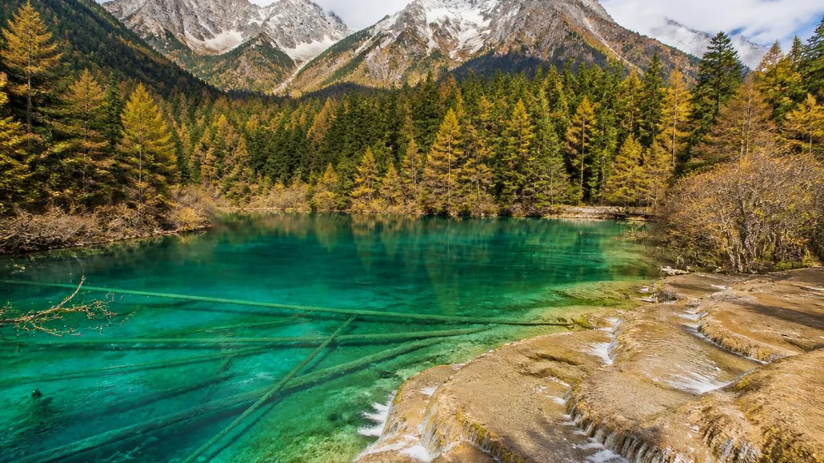
Then it reaches daylight, and the process reverses. Turbulence over a lip, a drop in pressure, a rise in temperature, and, importantly, the photosynthesis of algae and aquatic mosses stripping carbon dioxide out of the water, all push the chemistry the other way. Calcium carbonate comes out of solution and settles as a solid crust on whatever is there: rock, gravel, moss, waterfall lips, and the trunks of trees that fell into the lakes centuries ago.
That crust is travertine. It is why Jiuzhaigou looks nothing like an ordinary chain of alpine lakes. Glaciers and rockfalls made the original basins, but travertine is what dammed, sealed and terraced them into the stepped sequences you walk past: hundreds of lakes and shoals held behind natural barriers that the water itself keeps building.
It also means the system is alive and fragile. Direct contact with the lakes and the travertine is forbidden for visitors, and some of the less stable dams have been reinforced. A deposit that grows by a fraction of a millimetre a year does not recover from a boot print quickly.
Why blue-green, and why it changes by the hour
The travertine explains the shape. The colour needs two more mechanisms on top of it.
The first is what water does to light. Pure water absorbs long wavelengths, red and orange, far faster than short ones. Look through enough of it and what returns to your eye is weighted towards blue and green. Depth therefore sets the base tone, which is why a single lake reads pale at the rim and deep sapphire in the middle.
The second is what is suspended in it. Fine, near-colloidal particles of calcium carbonate scatter short wavelengths efficiently, adding the opaque, milky turquoise that photographs so implausibly. Underneath, the travertine floor is pale and highly reflective, so more light comes back up through the water column than a dark-bottomed lake would return.
Then biology adds the rest of the palette. Algae, aquatic mosses and submerged higher plants contribute greens, olives and golds; iron and organic staining in shallow patches adds rust and amber. Because the depth, the plant cover and the carbonate load all vary across a few metres, one lake can display half a dozen colours at once. That is the literal origin of the name of Five Flower Lake in Rize valley, whose shallow bed is criss-crossed by ancient fallen trunks, each of them travertine-coated.
Cloud, sun angle and season change the mix, which is why the same lake looks like a different lake at nine in the morning and four in the afternoon.
A Y with three arms, and a shuttle that assumes you walk downhill
Jiuzhaigou is arranged as a Y. Rize valley comes up from the south-west and Zechawa from the south-east; they meet near Nuorilang, and the combined flow runs north down Shuzheng valley to the mouth. Water leaves via the Bailong and Jialing rivers into the Yangtze system.
Lengths are quoted inconsistently, and it is worth knowing why. English-language sources typically give Rize and Zechawa as about 18 kilometres each and Shuzheng as 14.5. Chinese sources citing Chinese Academy of Sciences monitoring give Shuzheng about 13.8 kilometres, Rize about 25.3 and Zechawa about 31.7. The likeliest explanation is that one set measures the developed visitor corridor and the other the full gully, so do not try to reconcile them.
Elevations are more consistent: Shuzheng runs roughly 2,500 to 2,600 metres, Rize and Zechawa roughly 2,600 to 3,100.
The infrastructure follows the terrain. Roads inside the valley are given as 55 to 61 kilometres, with about 82 kilometres of boardwalk. Crucially, the boardwalks are built on the opposite bank from the road, so walkers are not sharing space with buses. The standard method is to ride the shuttle to the top of an arm, then walk down the boardwalks, rejoining the bus wherever the next feature is too far to reach on foot. Doing it the other way round means climbing stairs at 2,800 metres for no reward.
Five names you will hear all day
Nuorilang Falls sits at the junction of the three valleys and is the site’s emblem: about 20 metres high, and described as China’s widest waterfall and the world’s widest travertine-crested fall. Its width is given as 320 metres in English sources and 270 in Chinese ones, at an elevation around 2,365 metres. The name is a Tibetan transliteration, usually glossed as a male deity, implying grandeur.
Pearl Shoal, in Rize, is the mechanism from section one made visible: a wide, gently sloping sheet of actively depositing travertine under a thin film of moving water, which then drops 28 metres over a 310-metre curtain into the Pearl Waterfall. A scene from the television adaptation of Journey to the West was shot here, which in China is roughly equivalent to a landmark appearing in a national anthem.
Long Lake, at the top of Zechawa near 3,150 metres, is the highest, largest and deepest water in the valley: crescent-shaped, about 7.5 kilometres long, up to 103 metres deep, and reportedly without an outgoing stream, fed by snowmelt and drained by seepage. Local folklore supplies a monster.
Five-Colour Pond, also in Zechawa, is one of the smallest bodies of water on the map and among the most intensely coloured, which is a useful reminder that size and vividness are unrelated here.
Arrow Bamboo Lake, at 2,618 metres in Rize, covers about 170,000 square metres at a depth of roughly 6 metres. It carried a key sequence in the 2002 film Hero.
21:19, 8 August 2017
At 21:19 on 8 August 2017 an earthquake struck Zhangzha township in Jiuzhaigou County. The China Earthquake Networks Center recorded surface-wave magnitude 7.0 at a depth of about 12 kilometres; the United States Geological Survey put it at moment magnitude 6.5 at 9 kilometres. It was a strike-slip event, with maximum intensity assessed at IX on the Chinese scale.
The final national figures, published on 26 December 2017, were 29 dead, one missing and 543 injured, with direct economic losses of 8.043 billion yuan. Over 61,500 people were moved out of the area in the days that followed, including 126 foreign visitors. The valley closed to tourists on 9 August, the first closure since it opened to tourism in 1984.
Inside the scenic area the damage was specific rather than general. Slopes collapsed, boardwalks broke and floated, and several lakes were harmed to different degrees. Two of the injuries mattered more than the rest, because they were not to visitor infrastructure but to the travertine dams that make the landscape work.
The night Sparkling Lake emptied
Sparkling Lake, in Shuzheng valley, lost its outlet dam. Reports give the breach as 40 metres long, 12 metres wide and 15 metres deep. Peer-reviewed work on the event records the discharge rising from a normal 9.3 cubic metres per second to a peak of 21.5, with the water level dropping fast and the dam collapsing further as it went.
By the next day the lake was gone. What remained was worse than an empty basin: the exposed lake-bed travertine collapsed, weathered, sanded and blackened; cascade dams upstream cracked; downstream lakes silted up and began turning to marsh; and the risk of a further chain failure through the lake group threatened both residents and visitors below.
Nuorilang Falls cracked and partly collapsed on the same night, its curtain briefly reduced to muddy braids. The published analysis is unsentimental about why: the dam already had low stability, its material was mechanically weak and prone to rockfall even without an earthquake, and its near-vertical form amplified the shaking at the crest.
The argument about whether to mend it
What followed is the most interesting part of the story, and it is usually skipped.
Within days, Chinese geologists were publicly arguing against repair. Their position was that an earthquake reshaping a seismically formed landscape is a natural process, that the result might be a new landscape rather than a damaged one, and that intervention should avoid artificial materials and engineered structures on a natural World Heritage site. One specialist put the limit bluntly: a damaged landscape can be patched, but it cannot be restored, and bringing back a waterfall that has stopped by ecological means alone is close to impossible.
The principle finally adopted was a compromise, stated as natural recovery first, human intervention second. What is notable is how literally it was applied to materials.
At Nuorilang, a team from Southwest University of Science and Technology rebuilt the crest using the fall’s own fallen travertine, more than a hundred tonnes of it carried back up by hand. At Sparkling Lake, a Chengdu University of Technology project led by Pei Xiangjun spent roughly three years on a scheme built from glutinous-rice lime mortar, a traditional Chinese binder, together with rock that had collapsed in the quake and travertine soil, stabilised with vibro-replacement stone columns, bamboo anchor reinforcement and ecological slope work, and revegetated with native mosses. The administration states that the approach drew support from the UNESCO World Heritage Centre and the IUCN.
Sparkling Lake reopened shortly before National Day in 2020. Whether the result counts as the same lake is a question the site’s own scientists have been unusually willing to leave open.
Reopening, in four steps
The valley did not reopen; it reopened repeatedly, and the sequence is worth knowing because it explains why older guidebooks describe a place that no longer matches.
March 2018. A brief limited opening at 2,000 visitors a day, organised groups only, no independent travellers. It closed again.
September 2019. A real reopening on the 27th, with restricted zones and hours, a cap of 5,000 a day, online tickets and groups only. The open areas were Zharu monastery in Zharu gully, Shuzheng valley excluding Sparkling Lake, and Rize valley from Nuorilang up to Five Flower Lake.
November 2019. Independent travellers admitted from the 28th, with the cap raised to 20,000. On-site ticket windows were retired in favour of online real-name purchase for both entry and shuttle tickets.
September 2021. Full reopening of the whole area on the 28th, with the cap restored to around 40,000 and the Panda Lake tunnel between Five Flower Lake and the Primeval Forest in service. A new multi-level visitor complex at the valley mouth, built after the quake, covers about 26,600 square metres.
In 2024 the site recorded 5.11 million visitors. Every number in this section has been revised at least once, so check the day’s notice rather than this page.
1992 and 1997 are not the same certificate
Jiuzhaigou is routinely described as holding two UNESCO titles, which is true but usually misunderstood.
The 1992 inscription is on the World Heritage List, as a natural property, under criterion (vii) covering superlative natural phenomena and exceptional natural beauty, over an area of 72,000 hectares. That is a heritage designation, and it comes with reporting and protection obligations administered through the World Heritage Centre.
The 1997 listing is in UNESCO’s Man and the Biosphere Programme, a separate network concerned with reconciling conservation with sustainable human use through zoning and research. It is not a second heritage listing and does not upgrade the first.
Domestic designations sit alongside both. The State Council placed Jiuzhaigou in the first batch of national key scenic areas in November 1982. An administration bureau was established and the valley formally opened to visitors in January 1984. A master plan approved in January 1987 fixed the scenic area at 720 square kilometres with a 600-square-kilometre buffer. It was named in the first batch of national 4A scenic areas in 2000 and promoted to 5A in 2007.
Nine villages, thin air, and the season you pick
The name means the valley of nine stockaded villages, and the villages are Tibetan. Chinese records list them as Shuzheng, Heye, Zechawa, Panxin, Heiguo, Panyazhu, Guwa, Penbu and Jianpan, with transliterations varying between sources. Seven of the nine are still inhabited; two are not.
The permanent population inside the valley was given as about 1,000 people in 112 families in a 2003 assessment. Farming is no longer permitted within the protected area, so households depend on tourism work and government subsidy. That arrangement was tightened deliberately: from 2000 the valley has run a policy of visiting inside and sleeping outside, all hotels within the scenic area closed on 1 May 2001, and commercial and unauthorised buildings inside were demolished from 2003 onward. The result is a park with almost no accommodation and a strip of hotels at Zhangzha outside the gate.
Zharu valley, running south-east from Shuzheng, is the exception to the boardwalk-and-shuttle format. It begins at Zharu monastery and is the one place where a limited number of visitors can hike and camp with guides, along a pilgrimage route that circles the 4,528-metre sacred mountain Zha Yi Zha Ga.
For planning: most of what you will see lies between about 2,000 and 3,100 metres. The mean annual temperature is around 7.8 °C, with January near −3.7 and July near 16.8, and roughly 761 millimetres of rain, four fifths of it between May and October. Autumn is the colour peak and the crush. Winter freezes the falls and thins the crowds, at the cost of reduced arrangements in some sections. Access is by air to Jiuzhai Huanglong Airport, on a mountainside at about 3,448 metres and around 90 minutes away, or since 30 August 2024 by rail to Huanglongjiuzhai station on the Sichuan–Qinghai line, also about 90 minutes out.
Stand at Pearl Shoal for a minute before you leave and watch the film of water moving over the travertine. It is depositing as you look at it. That process built every dam in the valley over tens of thousands of years, an earthquake undid two of them in ninety seconds, and people spent three years putting one back using rice mortar and the rubble it had made. The colour, in the end, is a record of all three.
The LoreLens app can identify travertine dams, cascade formations and karst lake features while explaining the chemistry behind them.
Location profile
Where it is

Frequently asked questions
Why is the water that colour? Is anything added to it?
Nothing is added. The bedrock here is carbonate, mostly dolomite and limestone. Rain and snowmelt pick up carbon dioxide from soil and air, become weakly acidic, and dissolve calcium out of the rock. Where that water reaches the surface and loses its carbon dioxide, through turbulence, warming, falling pressure and photosynthesis by algae and aquatic mosses, the calcium comes back out as solid calcium carbonate. That deposit is travertine. It builds the natural dams that pond the water into steps, it coats fallen tree trunks on the lake floors, and it gives the lakes a pale, highly reflective bed. The colour on top of that bed is ordinary optics: water absorbs red and orange wavelengths faster than blue, so depth reads blue-green; fine suspended carbonate particles scatter short wavelengths and add the milky turquoise; algae and submerged plants contribute greens, golds and rusts. One lake can show several of these at once, which is how Five Flower Lake got its name.
Did the 2017 earthquake destroy Jiuzhaigou? What state are Sparkling Lake and Nuorilang Falls in now?
It damaged specific features rather than the valley as a whole, and the two most affected are both back. The magnitude 7.0 earthquake of 8 August 2017 breached the outlet dam of Sparkling Lake, opening a gap reported at 40 metres long, 12 metres wide and 15 metres deep; the lake emptied and its bed then degraded. It also cracked and partly collapsed the travertine crest of Nuorilang Falls. Both were treated under a stated principle of natural recovery first and human intervention second. Nuorilang was rebuilt using the fall's own collapsed travertine, more than a hundred tonnes of it carried back up. Sparkling Lake took roughly three years and used glutinous-rice lime mortar, rock that had collapsed in the quake and travertine soil, with vibro-replacement stone columns and bamboo anchors for stability; the administration says the approach was backed by the UNESCO World Heritage Centre and the IUCN. Sparkling Lake reopened shortly before National Day in 2020.
Do I need to book in advance, and how many people are let in?
Yes, and the numbers move. Tickets and shuttle-bus tickets are sold online under real names, and the on-site ticket window was discontinued. The daily cap has been reset repeatedly since the earthquake: 2,000 for the brief group-only reopening in March 2018, 5,000 from September 2019, 20,000 from that November, back to roughly 40,000 after the full reopening in 2021, with a figure of 41,000 reported more recently. The site received 5.11 million visitors in 2024 and more than 30,000 a day at the peak. Because the cap, the open sections, the shuttle routes and the entry hours have all changed more than once, treat any number you read, including the ones here, as historical and check the scenic area's own notice for the day you plan to travel.
When should I go, and how much of a problem is the altitude?
Autumn is the famous season, when the mixed forests turn and the lakes reflect them, and it is also the most crowded. Summer is mild, cloudy and wet, with about 80 percent of the year's roughly 761 millimetres of rain falling between May and October. Winter freezes the waterfalls into a different spectacle but some sections run on reduced arrangements or close. On altitude: most of what visitors see sits between about 2,000 and 3,100 metres, with the valley mouth near 2,000 to 2,140 metres and Long Lake around 3,150 metres. That is high enough to leave unacclimatised walkers short of breath on boardwalk stairs but low enough that serious altitude sickness is uncommon. The practical advice is to take the shuttle uphill and walk down, not the reverse, and to allow a full day rather than trying to compress three valleys into an afternoon.
Sources and further reading
Background references for the history and place names in this guide. Opening hours, ticketing and access change often — always confirm with official local information before travelling.