Hunan · Zhangjiajie
Zhangjiajie and Wulingyuan: Four Names, Four Different Places
A city renamed itself after a forest park, the forest park is only a fifth of the World Heritage site, and the World Heritage site has a different name again. Sorting that out is not pedantry—it decides which gate you queue at.
5A View location, maps and nearby scenic areasAlmost everyone arrives here having already made a mistake, and it is a mistake about names rather than about mountains.
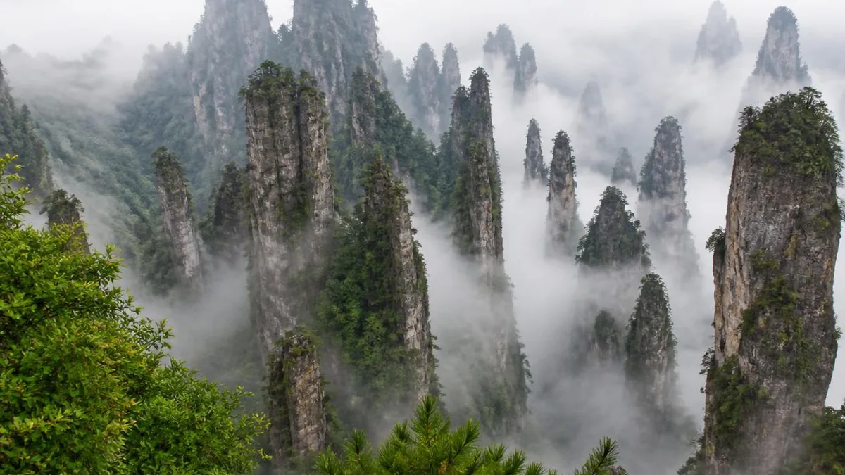
The place people picture—grey sandstone columns standing out of forest, cloud draining between them—has at least four official identities, each with a different boundary, a different founding date and a different bureaucracy behind it. The columns do not care. The ticket gates do.
Four names, and none of them is a synonym
Start with the largest and work in.
Zhangjiajie is a prefecture-level city in the northwest of Hunan, roughly 9,500 square kilometres of mountain, holding two districts—Yongding and Wulingyuan—and two counties, Cili and Sangzhi. Over six in ten residents are Tujia. This is the unit that appears on your flight ticket and your train ticket, and most of it is not scenic at all.
Wulingyuan Scenic and Historic Interest Area is the World Heritage property, inscribed in December 1992. Chinese sources put its total area at about 391 square kilometres with a core of more than 250; the inscribed property is recorded as roughly 26,400 hectares. It has four components: Zhangjiajie National Forest Park, plus the Suoxiyu, Tianzi Mountain and Yangjiajie areas.
Zhangjiajie National Forest Park is one of those four. It dates from 1982 and is described in official material as the first national forest park established in China. Its area is usually given as 4,810 hectares, though Chinese-language reference works also circulate a figure of 130 square kilometres—a discrepancy nobody has reconciled in print.
Wulingyuan District is the civil administrative unit, about 398 square kilometres, established by the State Council on 18 May 1988. Since April 1993 the district government and the scenic area administration have operated as one body under two signboards.
So the forest park is inside the scenic area, which is roughly coextensive with the district, which is inside the city, which is named after the forest park. Everything downstream of that sentence—your hotel, your shuttle, your gate—depends on knowing which one someone means.
Dayong changed its name for the tourists
The city was not called Zhangjiajie until living memory.
Dayong County became a county-level city in 1985 after State Council approval, formally constituted that October. In 1988 it was raised to prefecture-level status, assembled out of pieces taken from two different regions: Sangzhi and Dayong came out of the Xiangxi Tujia and Miao Autonomous Prefecture, Cili came out of Changde.
That reassembly was not administrative housekeeping. Chinese accounts record a boundary incident on 17 March 1987 at Zhimata, near Shuiraosimen, arising from overlapping management claims on the core scenery, and treat it as a direct cause of the prefecture-level city being created. Three counties had been developing three adjacent parts of one landscape in competition with each other.
Then, on 4 April 1994, Dayong City was renamed Zhangjiajie City. The stated reason is unusually frank: the name Dayong carried nowhere near the recognition of the national forest park inside it. A city took the brand of its own attraction.
This is why “Zhangjiajie” now points at three different scales at once—city, park, and loosely the whole scenery—and why a booking that says “hotel in Zhangjiajie” may put you an hour and a half of road from the gate you wanted.
What “Wulingyuan” actually meant before 1984
The heritage name is younger than the heritage, and it was borrowed from poetry.
Before the mid-1980s, Wulingyuan was a literary byword for Tao Yuanming’s Peach Blossom Spring—the hidden valley of the fable—and it appears in that sense in Wang Wei, Li Bai and Wang Anshi. It was not the name of this place.
The switch is well documented in Chinese sources. With Tianzi Mountain, Suoxiyu and the forest park in open dispute over boundaries, the provincial government decided to merge them under one administration and needed a name. In the winter of 1984 the painter Huang Yongyu proposed Wulingyuan, drawing on both the Wuling range that the site sits in and the literary association. The proposal passed the governor’s office meeting and was reported upward; in 1985 the general secretary of the day inscribed the three characters, and on 25 March that year the name appeared in a provincial report to the State Council.
The names of the components are older and stranger. Tianzi Mountain—Son of Heaven Mountain—is explained by the title claimed by a late Southern Song Tujia leader surnamed Xiang, and several place names inside it refer back to him. Suoxiyu is Tujia, usually glossed as something like “misty mountain village.” Yangjiajie, in the northwest, was only opened up as a distinct scenic area in 1992, and carries a Yang-family-generals legend supported locally by a surviving clan genealogy and Ming and Qing graves.
The rock is sandstone, and that changes everything
If you take one geological fact away, take this one: these are not karst towers.
The pillars are built from thick, flat-lying quartz sandstone of Middle to Upper Devonian age—Chinese geological literature names the Yuntaiguan and Huangjiadun formations. Quartz content is commonly given as 75 to 95 percent and the sandstone package as more than 520 metres thick. That composition is close to chemically inert. Limestone towers such as Guilin’s are sculpted by dissolution; quartz sandstone is not going to dissolve on any useful timescale.
What it does instead is break. The beds are nearly horizontal and cut by well-developed near-vertical joints, so the rock mass is pre-divided into rectangular blocks. Streams exploit the joints and cut down. Water freezing in the cracks in winter, and roots levering into them year-round, widen the joints from the inside. Once a slot is deep enough, the wall beside it loses support and falls—and the cliff face retreats, leaving whatever was between two slots standing alone.
That is the whole sequence: flat strong beds, vertical joints, downcutting, collapse, retreat. It explains why the columns have flat tops and sheer sides rather than the fluted, cave-riddled forms of limestone, and why so many of them still carry a forest on the summit—the top surface is the old land surface, not a spire eroded to a point.
Uplift supplies the energy. Chinese summaries run the sequence through the Wuling-Xuefeng, Indosinian, Yanshanian, Himalayan and neotectonic phases, crediting the Indosinian with the structural framework and the Himalayan and neotectonic movements with the relief that let rivers cut this deep.
Counting the columns, and what the numbers are worth
Chinese sources count 3,103 stone peaks. English-language sources round to “more than 3,000.” Both are defensible; neither is a census you could repeat.
The distribution is more informative than the count. Peaks stand at elevations of roughly 500 to 1,100 metres, with relative heights ranging from a few tens of metres to about 400. That range is the point: you are looking at one erosion surface at several stages of destruction at once, from broad plateau remnants that have barely begun to split, through knife-ridges, to isolated columns that are nearly gone.
The area totals move around depending on who is counting what. The heritage property is about 26,400 hectares; the scenic area is quoted at 391 square kilometres in Chinese sources and 397.5 in English ones; the administrative district is 398; and some English references give a figure near 690 for the site as a whole. These are almost certainly different boundaries rather than contradictory measurements of one boundary, but they are printed side by side without explanation, so do not stack them.
There is a further layer worth separating. In 2004 the area was admitted in the first cohort of what is now the UNESCO Global Geoparks network—a distinct designation from the 1992 World Heritage inscription, with its own, larger footprint centred on the sandstone peak forest. The two are frequently merged into one sentence on signboards. They are two different lists, awarded for two different reasons.
Yuanjiajie, and the pillar that got renamed
Yuanjiajie is the plateau most visitors mean when they say they came for the view. It is administratively part of the national forest park—official park material lists it among the park’s sub-areas alongside Huangshizhai, Pipaxi, Golden Whip Stream, Yaozizhai and Shadaogou—but it is reached from the Suoxiyu side, which is exactly the kind of thing that gets people lost.
Its landmarks are a natural sandstone arch usually rendered as First Bridge Under Heaven, a cluster of terraces looking into a bowl of columns, and one particular pillar.
That pillar was Southern Sky Column, also recorded as Qiankun Column. On 25 January 2010 the Yuanjiajie management committee announced it would be known as Avatar Hallelujah Mountain. Its elevation is given as 1,074 metres in Chinese sources and 1,080 in English ones, with a vertical height of roughly 150 metres.
The film connection needs care. Chinese accounts state that in December 2008 a Hollywood CG artist collected material in Wulingyuan for the production. But on 23 December 2009, at the Beijing premiere, James Cameron attributed the floating mountains to Huangshan—which triggered public objection from Hunan—and other statements from the production credit a set of Chinese landscapes including Guilin and Zhangjiajie. The renaming was contested even locally: a company spokesman denied that any renaming had taken place while a management committee official defended it as a change to a scenic-spot label rather than to a place name, and commentators criticised the whole exercise as commercial pandering.
None of it makes this a filming location. The honest version: a real visual-research trip, a disputed line of inspiration, and a marketing decision made fifteen years after the rock was already famous.
Golden Whip Stream, and the one walk with no machinery
Against all of the above, Golden Whip Stream is refreshingly simple. It is a valley path, several kilometres of it, following water along the floor of the forest park with the columns standing over you rather than below you.
This is the reverse of the Yuanjiajie experience and worth doing for that reason alone. From a terrace you see the peak forest as pattern; from the stream bed you see individual walls, the joints they split along, the boulder fans at their feet, and the wet, dense, evergreen-broadleaf forest that the heritage documentation is partly about. Chinese sources put forest cover across Wulingyuan near 88 percent and list the giant salamander among the protected species present.
Huangshizhai, on the other side of the park, is the classic high platform—the highest ground in the forest park, quoted around 1,050 metres, with a local saying to the effect that you have wasted the trip if you skip it. It can be walked or ridden.
Two contrasts, then, that the pillar photographs never show: the same rock read from below and from above, and the same landscape with and without a queue.
The lifts, and the arguments they started
Wulingyuan is unusually mechanised for a natural World Heritage site, and this is a live controversy rather than a settled one.
The Bailong Elevator is the emblem. Construction began in October 1999; it was completed and entered trial operation in April 2002. It runs 326 metres up a sandstone cliff, of which the lower section—about 154 metres—is inside a shaft cut in the mountain and the upper 172 metres is exposed steel derrick. Three double-deck glass cars, a reported cost in the region of 180 million yuan, and a 2013 upgrade that raised capacity and cut the ride to roughly a minute and a half. It has been recognised by Guinness World Records as the world’s tallest outdoor lift.
It was also stopped. Operations were suspended in late 2002 and resumed in August 2003, and the environmental objections have never gone away: Chinese reporting from the period quotes specialists arguing the structure damages the very landscape it serves, and a local environmental official saying it would probably not be approved today.
The broader record is blunter. Chinese sources state that Wulingyuan received formal warnings from UNESCO in 1998 and again in 2013—the first over the scale of construction, the second over inadequate geoscience interpretation—and that large-scale demolition of non-compliant buildings, vegetation restoration and the construction of a geopark museum followed. Take that as the frame for the elevator and the three cable cars: not villainy, but a park that has repeatedly been told it went too far and has repeatedly rebuilt.
Why visitors get lost here more than anywhere else
The disorientation has a specific cause, and it is not the scenery.
Most large Chinese scenic areas are one gate and one loop. Wulingyuan is four historically separate developments—the forest park, Suoxiyu, Tianzi Mountain and Yangjiajie—stitched together in the 1980s after a boundary dispute, with multiple entrance gates spread around the perimeter and free shuttle buses running fixed internal routes between them. Vertical movement is by machinery: the Bailong Elevator plus cable cars serving Tianzi Mountain, Yangjiajie and Huangshizhai, each doing one ascent and only one.
The consequence is that the map in your head is topographic and the actual network is a timetable. Two viewpoints a kilometre apart in a straight line may be an hour apart by the only legal route. Entering at the wrong gate can cost most of a morning.
Practical shape, deliberately kept general: give the core two full days, three if you want Yangjiajie without hurrying; pair the Golden Whip Stream valley with Yuanjiajie’s terraces on one day and give Tianzi Mountain its own; expect the shuttles rather than your legs to define the itinerary. Everything specific—the ticket price, how many days it stays valid, which lifts are included, which gates are open, whether you need to book ahead—has changed more than once and is a matter for the official notice on the day, not for any article.
And keep two nearby attractions mentally separate: Tianmen Mountain, which is a different mountain above the city with its own ticket and its own cableway, and the Zhangjiajie Grand Canyon glass bridge, opened in 2016 in Cili County, which is a separate site again.
Stand under one column and read it downward
Before you leave, find a spot on the valley floor where a single pillar rises clear of its neighbours, and read it from the top down.
The flat summit with trees on it is a fragment of an old land surface—ground that was once continuous with everything around you. The vertical faces are joints, fractures that were in the rock before any of this was scenery, simply opened up. The talus at the base is the material that used to fill the space you are standing in. Nothing here was carved. It was quarried, by water and ice and roots, along lines the rock had already drawn.
That is also, oddly, the shape of the naming problem. A county called Dayong took a park’s name; a park took its name from a family surname on a stream; the heritage site took its name from a Tang and Song poetic fiction about a hidden valley. Four labels applied at four different times to one body of rock that was here, and coming apart on its own schedule, long before any of them.
The LoreLens app can identify quartz sandstone peak-forest landforms, joint systems and collapse features on the spot, and explain the geology behind what you are looking at.
Location profile
Where it is

Frequently asked questions
Is Zhangjiajie the same thing as Wulingyuan?
No, and the confusion is built into the map. Zhangjiajie is a prefecture-level city of roughly 9,500 square kilometres; it was called Dayong until 4 April 1994, when it took the name of its most famous attraction. Wulingyuan is the scenic area inside that city, inscribed on the World Heritage List in December 1992 as the Wulingyuan Scenic and Historic Interest Area, with an inscribed property of about 26,400 hectares. Zhangjiajie National Forest Park—established in 1982 and described in official material as China's first national forest park, with an area usually given as 4,810 hectares—is only one component of Wulingyuan; the others are the Suoxiyu, Tianzi Mountain and Yangjiajie areas. There is also a Wulingyuan District, the civil administrative unit, about 398 square kilometres. Four names, four boundaries. Hotel listings, bus signs and ticket windows use them interchangeably, which is why so many visitors book the wrong side of the mountain.
Are the pillars karst, like Guilin?
No, and this is the single most useful thing to know before you look at them. Guilin's towers are limestone dissolved by slightly acidic water—a chemical process. Wulingyuan's pillars are quartz sandstone of Middle to Upper Devonian age, described in Chinese geological sources as the Yuntaiguan and Huangjiadun formations, with quartz content commonly given as 75 to 95 percent and a stratum thickness of more than 520 metres. That rock barely dissolves. It fails mechanically instead: near-vertical joint sets divide the flat-lying beds into blocks, streams cut down along the joints, freeze-thaw and plant roots widen them, and the walls between them collapse and retreat until only columns are left. Chinese sources count 3,103 stone peaks, standing at elevations of roughly 500 to 1,100 metres with relative heights from a few tens of metres to about 400. Limestone caves do exist in the area, but they are a separate story in a separate rock.
Was Avatar filmed here, and did a pillar really get renamed?
The renaming is documented; the film connection is not as clean as the signs suggest. On 25 January 2010 the Yuanjiajie management committee announced that the pillar known as Southern Sky Column, also recorded as Qiankun Column, would be called Avatar Hallelujah Mountain. Chinese accounts add that a Hollywood CG artist gathered visual material in Wulingyuan in December 2008 for the production. But at the Beijing premiere on 23 December 2009 James Cameron attributed the floating mountains to Huangshan, which provoked objections from Hunan; other statements from the production credit several Chinese landscapes, Guilin and Zhangjiajie among them. The renaming was also publicly disputed at the time—a company spokesman denied it while a management committee official defended it as a scenic-spot label rather than a place name. Treat it as marketing with a partial factual basis, not as a filming location.
How much time does Wulingyuan need, and why do people get lost?
Two full days is a workable minimum for the core and three is more comfortable, because the site is not one park but several joined by transport. Most visitors combine the Golden Whip Stream valley walk with Yuanjiajie for the pillar viewpoints, then take a separate day for Tianzi Mountain and, if there is time, Yangjiajie. People get lost because the connections are mechanical rather than geographic: free shuttle buses run fixed routes between gates, the Bailong Elevator and three cable cars each serve one specific ascent, and the same viewpoint can be reached by two systems with different queues. The ticket, its validity period, the shuttle routes, which lifts are included and whether advance booking is required have all changed more than once—check the official notice on the day rather than an itinerary written last season. Note too that Tianmen Mountain and the Zhangjiajie Grand Canyon glass bridge are separate sites with separate tickets.
Sources and further reading
Background references for the history and place names in this guide. Opening hours, ticketing and access change often — always confirm with official local information before travelling.