Hunan · Zhangjiajie
Tianmen Mountain: The Other Mountain, and a Hole in It
Half the visitors who fly to Zhangjiajie think Tianmen Mountain and the Wulingyuan pillars are the same place. They are different rock, different tickets, different owners, and about an hour apart—and Tianmen is the one that sells engineering.
5A View location, maps and nearby scenic areasThere is a mountain directly above the city of Zhangjiajie, and a great many people who travel across the world to see the region never work out that it is not the mountain they came for.
The confusion is understandable. Both are in the same prefecture. Both are marketed under the word Zhangjiajie. Both put you on a cliff edge looking down. But they are made of different rock, they were built out by different organisations under different legal arrangements, they are an hour or so apart by road, and they share no ticket. Tianmen Mountain is the one you can reach from the railway station.
One city, two mountains, two of everything
Tianmen sits in Yongding District, the urban district of Zhangjiajie City. Its cableway base station is in town, next to the railway station—an unusual arrangement that tells you a great deal about how the mountain was developed.
Wulingyuan, the World Heritage property inscribed in 1992, lies to the northeast in its own administrative district. That is where the quartz sandstone pillars are: Zhangjiajie National Forest Park, Yuanjiajie, Tianzi Mountain, Yangjiajie.
They are not the same landscape and they are not the same rock. Tianmen was approved as a national forest park in July 1992, with a management office established the following month, and its area is generally quoted at somewhat over 190 square kilometres. Its main summit is given as 1,518.6 metres, with average elevations above 1,400.
The practical version is short. Two mountains, two gates, two fares, two half-to-full days. And a third site people also merge into the picture—the Zhangjiajie Grand Canyon glass bridge, opened in 2016 over in Cili County—which is separate again.
Limestone, not sandstone
This is the difference that makes everything else make sense.
Wulingyuan’s columns are quartz sandstone: chemically stubborn, split by vertical joints, taken apart mechanically by water, ice and roots. Tianmen is limestone, and Chinese descriptions characterise it as karst developed on a platform-shaped massif, formed through the Yanshanian tectonic phase, lifted further by the Himalayan orogeny, and then worked on by weathering. Its vegetation is described as primary secondary forest.
Limestone behaves in the opposite way. Rainwater picks up carbon dioxide, becomes weakly acidic, and dissolves calcium carbonate along joints and bedding planes. It works from the inside out. Over time you get fissures widening into passages, passages into chambers, chambers into cave systems—and, where a chamber intersects the outside of a mountain and its roof or wall gives way, an opening straight through.
That is the mechanism you should have in mind for the arch. It is also why the summit is a broad tabletop rather than a forest of spires: you are standing on a resistant platform whose edges have been undercut and dissolved back, not on a residual column.
Both mountains, in other words, were shaped by water finding weaknesses. The rock decided whether that produced pillars or a hole.
The hole reported to a king in 263
The dating of Tianmen Cave is unusually specific for a landform, because a state paperwork trail survives.
Chinese accounts record that in 263, during the Three Kingdoms period, the mountain was reported to have suddenly split open into a great cavity. Local officials passed this up to Sun Xiu, ruler of the state of Wu, who interpreted it as an auspicious sign and gave it the name Tianmen—Heaven’s Gate. The mountain took its name from the hole, not the other way around.
Read alongside the geology, this is coherent. A limestone cave system does not appear in a year; a roof collapse does. What was recorded in 263 is best understood as a failure event that opened an existing void to daylight, which is exactly the sort of thing that would be visible from the valley overnight and worth reporting to a court.
It is worth noticing that the reading was political. A mountain splitting open could as easily have been logged as a portent of disaster; a court that wanted an omen of legitimacy got one, and the name has outlasted the dynasty that awarded it by seventeen centuries.
The dimensions in circulation are roughly 131.5 metres high, 57 metres wide and 60 metres deep. English accounts of the 2011 wingsuit flight through it describe an archway around 30 metres wide, which is almost certainly a measurement of the tightest part rather than a competing figure. And the rock is still moving: a visitor was killed by a falling rock at the cave in July 2016.
The cableway, and the superlatives attached to it
The mountain’s signature approach is a gondola that starts in the middle of a city and ends on a cliff.
It was built in 2005 by the French manufacturer Poma. The figures repeated most consistently are a slope length of 7,455 metres, a vertical difference between stations of 1,279 metres, 98 cars, and a maximum gradient of 37 degrees.
The superlative attached to it needs a qualifier put back in. Tourist material tends to say “the world’s longest cableway.” The Chinese technical description is narrower and more defensible: the longest monocable circulating detachable gondola of its kind—a specific class of lift, not all lifts everywhere. Longer aerial ropeways of other types exist. This is the same pattern as most Chinese scenic-area records: the claim is usually true inside a category the brochure has dropped.
What the ride actually delivers is the thing the numbers do not convey. You leave from beside the railway station, cross the roofs of a working prefecture capital, and then the ground drops away as the line crosses onto the massif. Very few mountain lifts anywhere begin in traffic.
Ninety-nine bends up a limestone wall
The road is the other famous approach, and it is a genuine piece of engineering rather than a piece of theming.
Tongtian Avenue—usually rendered as Avenue Toward Heaven—is quoted at 10.77 kilometres in Chinese sources and about 11 in English ones, and it climbs the flank of the mountain in 99 bends. The number is auspicious rather than accidental; nine is the emperor’s number, and the repetition of nines here, in the steps and in the road, is deliberate.
It is normally driven in scenic-area buses rather than private cars, and the bends are tight enough that the experience is closer to a fairground ride than a drive. It has also become a stage. In September 2016 the Italian driver Fabio Barone set a timed record on the route in a Ferrari 458 Italia at 10 minutes 31 seconds; the road has hosted road-skating stunts and been used repeatedly in car advertising.
Whether you take the road up and the cable down, or the reverse, has depended on which one-way circuit the operator is running in a given season. That is not a detail you can fix in advance from an article—it is a matter for the day’s notice at the gate.
Nine hundred and ninety-nine steps, and what replaced them
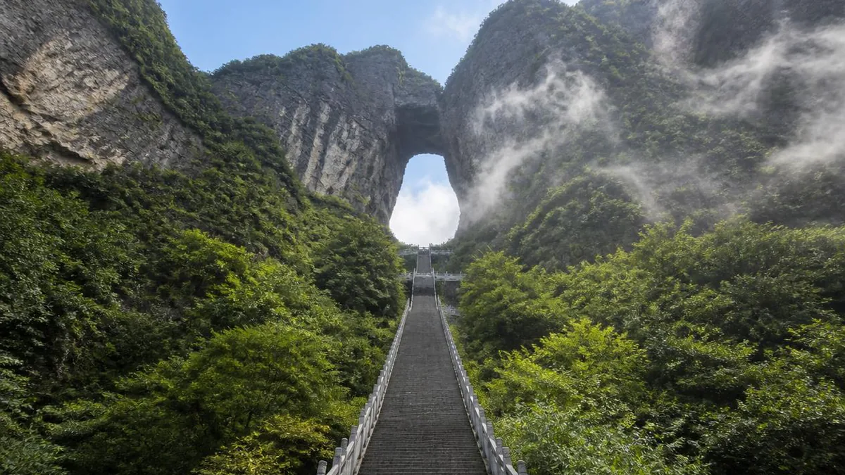
Where the road ends, a staircase runs up to the cave: 999 steps, marketed as the Stairway to Heaven.
They are steep, they are exposed, and they are the last stretch of the traditional pilgrimage route. Walking them is the only part of the modern Tianmen experience that resembles how the mountain was actually approached for most of its history.
For those who cannot, an escalator system was later driven into the mountain to carry visitors up through the rock to the cave, and further escalators were installed on the summit. These are the projects that drew the sharpest criticism. Chinese reporting has faulted the scenic area for destructive development and commercial hype, and specifically alleged that chairlift and elevator works carried out without proper approval damaged forest resources and the Tianmen Cave massif itself.
That criticism is worth holding alongside the ticket. Tianmen is not a landscape lightly furnished with paths. It is a mountain that has been comprehensively engineered—cableway, road, staircase, internal escalators, cantilevered walkways—and the engineering is a substantial part of what is being sold. Whether the balance was struck correctly is exactly what has been argued about.
In 2018 a hybrid Range Rover Sport driven by Ho-Pin Tung was taken up the 999 steps as a publicity stunt. In November 2025 a Chinese manufacturer attempted to repeat the climb, lost traction partway, slid back and broke part of the staircase wall; the company apologised publicly and undertook to repair the damage. The mountain-as-stage has costs that occasionally land on the mountain.
Walking on glass, in sections that keep changing
The cliff walkways are the summit’s main attraction and the hardest thing to describe accurately, because they keep changing.
The oldest is the Guigu plank road, named for the Guigu cave on the cliff below it, a long cantilevered path pinned to a vertical face on the west side. The much-photographed glass-floored stretch on this side is short—Chinese sources give a length of about 60 metres, with its high point at roughly 1,430 metres elevation. In August 2016 a second glass skywalk opened on the Coiling Dragon Cliff, looking down onto Tongtian Avenue and its bends.
The important thing for planning is that the glass is a small fraction of the walkways. Most of the route is ordinary cantilevered path with a rail, and that is where the exposure actually is. The glass sections are the part everyone photographs and, in practice, the part most likely to be shut: they have been closed for maintenance, for cleaning, and for crowd control, and which sections are open on which day is genuinely variable. Shoe covers are normally required.
They also read completely differently in weather. In cloud you see nothing beneath you and the whole exercise becomes abstract; in clear air the drop is fully legible. Neither can be booked.
Flying through the hole, 1999 to 2020
Tianmen Cave is one of a very small number of natural openings on earth large enough to fly an aircraft through, and it has been used that way for a quarter of a century. This part of the record deserves to be stated plainly and without embellishment.
The city’s own account of its promotional history lists a world aerobatic flying competition held at Tianmen Mountain in 1999, and an aerobatic display by Russian air force pilots in 2006. In November 2007 the French climber Alain Robert climbed the cliff below the arch without protection, at the invitation of the local government.
Wingsuit flight came next. On 25 September 2011 the American BASE jumper Jeb Corliss exited a helicopter at around 1,800 metres and flew a wingsuit through the arch, landing under canopy nearby. The first World Wingsuit Championship was held here in October 2012, won by the South African Julian Boulle with a time of 23.410 seconds. The second followed in 2013, won by the Colombian Jhonathan Florez in 23.40.
Three deaths are on the record. On 8 October 2013, during training for the second championship, the Hungarian flier Viktor Kováts fell to his death near the 84th bend of the mountain road, his parachute unopened. On 26 January 2017 the Canadian flier Graham Dickinson died while training alone on the eastern walkway side of the mountain. On 12 May 2020 a 24-year-old Chinese university student went missing during a wingsuit flight here; her body was found on 18 May, her parachute undeployed.
These are not anecdotes about a scenic spot. They are the cost of a particular use of a particular piece of geology, and the record is short enough that every name in it can be written down.
The temple on top, and a mountain that is privately run
The summit is not only a viewing platform. Tianmenshan Temple stands there, and Chinese sources describe it as the highest-elevation Buddhist temple in Hunan, on grounds of about two hectares, tracing its lineage to a Tang-dynasty foundation called Lingquan Yuan that fell into ruin and was rebuilt on its old site.
The rebuilt temple’s dating and style are described inconsistently. Chinese sources characterise the present buildings as Qing in style and northern in manner; English sources say construction of a Tang-style replacement began in 1949. Both cannot be right, and neither carries a citable source. What is agreed is that the current complex is a modern reconstruction on an old site, and that in June 2009 a relic of the Buddha from Lumbini in Nepal was enshrined here, described locally as the first such relic in Hunan.
There is also a quieter story on the summit. In May 1997 the singer Li Na, then among the most successful vocalists in the country, visited Tianmen Mountain, moved her household registration to Yongding District within weeks and had a villa built on the mountain. About a month later she took monastic vows at a temple on Wutai Shan, and subsequently left for the United States. The villa remains.
The whole mountain, meanwhile, is run under a commercial concession. In August 2001 a private group signed a fifty-year contract with the Yongding District government for the entrusted development and operation of the national forest park, covering some 1,700 mu, and set up a tourism company to do it; the scenic area formally opened in September 2005. That is the structural difference from Wulingyuan, and it explains most of the rest.
Stand under the arch and look up
Before you climb the steps, stop at the bottom of them and look up through the opening.
What you are seeing is the ceiling of a cave that lost its floor of rock and gained a ceiling of sky. Water spent an unimaginable amount of time dissolving a void inside a limestone platform, and then, at some point that a court clerk in 263 wrote down, the wall between that void and the outside world failed. Everything since—the name, the temple, the road, the cableway, the men and women who have flown aircraft and fabric wings through the gap—has been a response to a hole that the mountain made by accident.
That is also the honest answer to the question people arrive with. Tianmen is not a smaller version of Wulingyuan and not a stop on the way to it. It is a different rock doing a different thing, with a city at its feet and a great deal of steel bolted to it. Go for the hole, the walls and the record of what people have done with them—and buy the other ticket separately.
The LoreLens app can identify karst landforms, collapse arches and cliff-edge structures on Tianmen Mountain and explain how they formed.
Location profile
Where it is

Frequently asked questions
Is Tianmen Mountain part of Zhangjiajie's World Heritage site?
No. This is the most expensive misunderstanding in the region. Tianmen Mountain is in Yongding District, immediately above the city of Zhangjiajie, and its cableway base station is beside the railway station. Wulingyuan—the World Heritage property inscribed in 1992, containing Zhangjiajie National Forest Park, Yuanjiajie, Tianzi Mountain and the rest—is a separate area to the northeast, roughly an hour or so away by road. They are made of different rock, they were developed by different bodies, and neither ticket admits you to the other. The Zhangjiajie Grand Canyon glass bridge, in Cili County, is a third separate site. Budget them as three visits, not one.
What actually formed Tianmen Cave?
The mountain is limestone, and Chinese sources describe its landform as karst on a platform-shaped massif, shaped through the Yanshanian tectonic phase and the later Himalayan orogeny and then by weathering. That matters, because limestone dissolves in mildly acidic water in a way that Wulingyuan's quartz sandstone does not: water works along joints and bedding planes, opens cavities inside the rock, and when a cavity intersects a cliff and its roof or wall fails, you are left with an opening through the mountain. The historical record fits that mechanism. Chinese accounts date the appearance of the opening to 263, when the mountain was reported to have split; officials reported it to Sun Xiu, ruler of the state of Wu, who read it as an auspicious omen and gave it the name Heaven's Gate. So the cave is a collapsed cave system, and 263 records a collapse rather than the cave's creation. Rockfall here is not purely historical—a visitor was killed by a falling rock at the cave in July 2016.
How big is the cave, and how long is the cableway?
Both figures are quoted inconsistently, so hold ranges. Chinese reference sources give the cave as about 131.5 metres high, 57 metres wide and 60 metres deep; English accounts of the 2011 wingsuit flight through it describe an archway around 30 metres wide, which is probably a narrower measurement rather than a contradiction. The cableway is more consistent: a slope length of 7,455 metres and a vertical difference of 1,279 metres between stations, with 98 cars and a maximum gradient of 37 degrees, built in 2005 by the French manufacturer Poma. It is widely marketed as the world's longest cableway of its type—a monocable detachable gondola—which is a narrower claim than the flat superlative on the brochures. The mountain's main summit is given as 1,518.6 metres.
Which parts should I actually plan for, and what changes?
The fixed elements are the cableway from the city, the road with 99 bends, the 999 steps under the cave, the summit loop with its temple, and the cliff-edge walkways—several of which have glass floors. Everything about how you combine them moves. The scenic area has run different one-way circuits in different seasons, meaning cable car up and bus down or the reverse; glass walkway sections and the escalator system inside the mountain have been closed for maintenance or crowd control; and timed-entry booking has been in force in some periods and not others. Fog is common enough that the summit view is a lottery, and the walkways feel very different in rain. Do not plan from an itinerary written last season—check the operator's notice for the day at the gate, and allow half a day at minimum, most of a day if you want the walkways without rushing.
Sources and further reading
Background references for the history and place names in this guide. Opening hours, ticketing and access change often — always confirm with official local information before travelling.