Anhui · Huangshan
Mount Huangshan: The Viewfinder of Chinese Landscape Painting
A granite pluton that cooled eight kilometres underground, two sets of cracks that decided every named rock on it, a glacier argument still open after ninety years, and the most famous sentence about the mountain, which nobody can find in the book it is credited to.
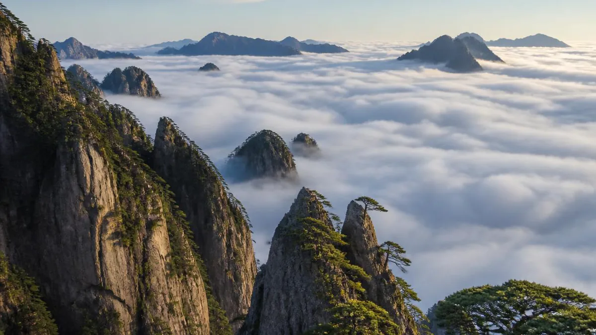
5A View location, maps and nearby scenic areasChinese landscape painting has a habit that puzzles first-time viewers: the mountains look impossible. Peaks rise as vertical shafts with no visible base, pines grow sideways out of bare rock, and the middle distance is missing—replaced by white space that reads as cloud. It looks like stylisation. On the summit plateau of Huangshan in southern Anhui, on the right morning, it looks like reporting.
Huangshan is not a mountain painters happened to like. Its geometry—shafts, gaps, sideways trees, a floor of cloud—handed Chinese landscape art a subject that matched what it already wanted to do. And that geometry is the behaviour of one body of granite along two sets of cracks.
A pluton that cooled eight kilometres underground
Granite is an intrusive rock: magma that never reached the surface. Around 120 million years ago, in the Cretaceous, magma rose under this part of Anhui and froze at a depth of roughly seven to eight kilometres into one large body.
The mountain is the story of that body being uncovered. Uplift and erosion stripped the cover off layer by layer, and the granite is described as reaching the surface around 13 million years ago. The peaks and gorges visitors photograph are younger still, forming over roughly the last million years; a fault between Yungusi and Baiegang carries friction marks dated to about 270,000 years, which is what fixes that timing.
Two generations of landform result, and you can walk from one to the other. The older is gentle: near-level ground formed while the crust was quiet, then lifted intact as a planation surface. Guangming Ding, at 1,860 metres, sits on one, which is why the last stretch gets easier rather than harder. Xu Xiake caught it in ten characters: steep gullies on all four sides, and this alone like flat ground. The second generation is the opposite—fast uplift, rivers cutting down, spires and walls. Lianhua Feng, the highest peak, is given as 1,864 metres; Tiandu Feng as 1,810 in Chinese sources and around 1,829 in English ones.
Two sets of cracks, and every rock they named
Granite cracks as it cools. Contraction opens fractures called joints, some vertical, some horizontal, and at Huangshan the vertical set is strongly developed. That single fact produces most of what the guidebooks list as scenery: a cliff face here is usually an exposed joint plane, and a freestanding shaft is a block that vertical joints isolated and horizontal joints undercut.
Two weathering processes then finish the work, and they leave different signatures.
Above roughly 1,800 metres the mountain gets a periglacial regime—not glaciers, but repeated freeze and thaw. Water in joints and between mineral grains freezes, expands and prises the rock apart, leaving a scatter of columns: the formations sold as Eighteen Arhats Facing the South Sea and Immortal on Stilts are frost-weathered rock pillars.
In warmer, wetter phases, chemical weathering attacks edges and corners first, because those points are exposed from more directions at once. Corners round off and the block ends as a sphere. This is spheroidal weathering, source of the granite “stone-egg” forms: Monkey Gazing at the Sea below Shizi Peak, the Snail atop Aoyu Peak, the Immortal Peach on Tiandu.
So the grotesque rocks of the famous list are not a menagerie. They are a joint census with two weathering styles applied; the names came later.
The glacier question nobody has closed
There is one more possible sculptor, and it is the most argued-over topic in Chinese geomorphology.
In May 1936 Li Siguang came to Huangshan with an assistant, read the valleys as U-shaped, and published a paper on the mountain’s Quaternary glacial phenomena. It followed his earlier work at Lushan and became a cornerstone of the claim that eastern China had been glaciated—a claim foreign geologists had largely denied, so the finding carried national weight. Li was also, incidentally, recruited to the Huangshan Construction Committee that opened the mountain to modern tourism in the 1930s.
The challenge came from a glaciologist who started out an admirer. Shi Yafeng spent years on modern glaciers in western China, then watched a debris flow in southeastern Tibet in 1964 and a landslide dam in Yunnan in 1965. Both produced what he had been taught to read as glacial: chaotic mixed deposits, ridge-shaped dams, striated boulders far from bedrock. In 1980 he took a team to Lushan to re-examine Li’s own sites, and reached the opposite conclusion. With Cui Zhijiu, Li Jijun and some thirty colleagues he published a study whose summary is blunt: only a few high mountains in eastern China carry unambiguous glacial traces, and the disputed sites below about 2,000 metres—Lushan, Huangshan, the Guilin hills—are misreadings. He restated it in 2010, reading Lushan’s supposed till as debris flow.
The other side has not conceded, and that paper opened a fresh round rather than closing one. In 2017 Pu Qingyu, co-author of a government-commissioned study of Huangshan’s granite landforms, put it plainly: the question remains undecided, and while it is undecided the geopark should explain both readings and let visitors go and look. A guide who tells you ice carved these gorges is repeating one side of a live argument.
Cloud that behaves like water
The element that makes the paintings legible is the sea of clouds, and the mechanism is unglamorous: moist air circulating through deep valleys on a high, steep, heavily vegetated mountain in a humid subtropical monsoon climate condenses into low stratocumulus that pools below the summits. Huangshan records more than 250 days a year with cloud or fog. When the layer sits below you the middle distance genuinely disappears, and what remains is the composition of a hanging scroll: near rock, white gap, far rock.
The naming follows the effect: sectors of the summit area are the North Sea, South Sea, East Sea, West Sea and Sky Sea. Most mountains, as the line goes, are enjoyed by looking up; this one by looking down.
The related optical event is Buddha’s Light, a glory: your own shadow thrown onto cloud inside coloured haloes, reported at a couple of appearances a month. The fourth classical wonder sits at the bottom of the mountain—the hot spring below Ziyun Peak, around 42°C year-round and carbonate-rich, in the earliest developed part of the massif. Winter snow is often counted as a fifth.
Pines that grow in cracks
The tree on every poster carries the mountain’s name. Pinus hwangshanensis, the Huangshan pine, was described as a distinct species in 1936 by the botanist Xia Weiying, who named it for this place. Its cultural value comes from where it grows: apparently out of bare rock, at absurd angles, on cliff edges. The mechanism is the same joint system that made the cliffs—roots exploit the fractures and reach the soil and water trapped inside them. The old formula, no peak without rock, no rock without a pine, no pine that is not strange, is a description of joint distribution, and the preference for the most contorted trees is an aesthetic preference for the most constrained growth form.
Around a hundred pines are individually named here, ten of them canonical. Naming is not preservation: the Farewell Pine died in the winter of 2005 and a replacement was designated in its place.
The Welcoming Pine has a staff of nineteen
The Welcoming Pine stands beside Yupinglou above Wenshu Cave, rooted in a crack. It is the most reproduced image in Chinese scenic tourism—a version hangs in the Great Hall of the People, and printed copies in an enormous number of living rooms. It is also managed like infrastructure, which is more interesting than the folklore.
Since 1981 the tree has had designated full-time keepers. Hu Xiaochun, in post since 2010, is counted as the nineteenth: he works from a roughly six-square-metre monitoring room a few metres away, checks the tree through the day and keeps a written log. He has been named a national model worker and sits as a deputy to the National People’s Congress.
The tree is also propped. A new support frame was installed in early 2006, after some three months of work, because the crown had grown and the old frame no longer fitted; it stands about fifteen metres and carries lightning protection. The outstretched limb that makes the silhouette—usually given as 9.6 metres—rests on elastic props rated to several tonnes each, designed to damp movement and carry snow and ice. Extra props go on before heavy snowfalls, and the tree gets periodic formal inspections.
Its age is the least reliable number attached to it: published figures include roughly 800 years, about 1,000, more than 1,300 and more than 1,500. The dimensions are steadier—about 10 metres tall, girth around 2.16 metres, that limb at 9.6. Take the steel, not the millennium.
Nobody can find the sentence Xu Xiake is famous for
The line every Chinese visitor can recite runs: return from the Five Great Mountains and you will not look at mountains; return from Huangshan and you will not look at the Five Great Mountains. It is attributed to the Ming traveller Xu Xiake, who climbed Huangshan twice, in 1616 and 1618, and left two detailed diary entries. Neither contains the couplet, and no edition of his collected diaries does.
What exists is a chain assembled over three centuries. The earliest documented version of his verdict appears in the Huangshan Zhi Dingben, a gazetteer completed by the Shexian scholar Min Linsi in 1679, thirty-eight years after Xu’s death. Asked which of all the mountains he had travelled was the most remarkable, Xu there answers: within the seas and beyond them there is nothing like Huangshan of Huizhou; climb Huangshan and there are no mountains left. That is a report of speech, not a text by Xu, and it is absent from the biography written by his friend Qian Qianyi.
The couplet itself has two separate parents. The upper line belongs to the Qing scholar Sang Diaoyuan (1695–1771), who had travelled the Five Great Mountains and hung a self-composed couplet in his hall pairing read the Six Classics through before taking up the brush with return from the Five Mountains and look at no mountains. It is about scholarly qualification, and Huangshan is not one of the Five. The lower line first appears in the Huangshan notes of Wang Lüben (1867–1931) of Shexian, preserved by Xu Chengyao in his Shexian Miscellany: where the ancients said that of the Five Mountains, Wang wrote, he would say pass through Huangshan and look at no Great Mountains.
The stitching and the misattribution are twentieth-century. Xu Shiying, who founded and chaired the Huangshan Construction Committee in 1934, printed the joined couplet in a New Year’s Day 1935 newspaper article and credited it to Xu Xiake—the earliest known link between the man and the sentence. The essayist Han Zi quoted it the same way in 1957, in a piece later set as a school textbook reading.
The verdict is Xu Xiake’s in spirit and nobody’s in particular in wording—a fair description of how mountain reputations get built.
The painters who turned a mountain into a genre
The World Heritage citation does something unusual: it grounds the listing in art history, praising the mountain’s standing during the mid-sixteenth-century flowering of Chinese landscape painting. That is the cultural half of the mixed inscription.
A Huangshan school formed in the late Ming and early Qing around three principals: Hongren, Mei Qing and Shitao. What made it a school rather than a subject was method—they stayed on the mountain and worked from it instead of reproducing inherited compositions. Shitao is credited with being the first to paint all seventy-two named peaks; the later master Huang Binhong called himself a man of the Huangshan mountains.
The volume behind that is real—more than 20,000 poems about Huangshan are counted from the Tang to the end of the Qing, Li Bai’s among the earliest, and cliff inscriptions are cut all over the rock, the largest with characters six metres square. The mountain even supplied its own art material: by the Southern Tang, craftsmen were making Huizhou ink from the soot of Huangshan pine.
The people who carry the hotels up
There is no service road to the summit hotels. Everything consumed up there—food, bedding, gas, beer, building material—arrives on someone’s shoulder.
The porters are a working occupation, not a photo opportunity. They carry loads slung from a shoulder pole and take switchbacks rather than the direct line, because extra distance costs less than extra gradient. Reported loads run from roughly 50 to 75 kilograms, and pay is usually described as a rate per unit of weight, working out to something in the low hundreds of yuan for a day’s climbing. No official figures are published; those numbers come from journalists and travellers asking on the trail, so treat them as a range, not a wage table. Freight now often goes part-way by ropeway and is carried on from the upper stations.
If you photograph them, buy something at the top. The price of the bottle is the arithmetic of the climb.
Getting on the mountain, and the numbers that disagree
The mountain has a front and a back. The front approach starts at Ciguangge and climbs past Yupinglou and the Welcoming Pine; the back starts at Yungusi and rises to Baiegang and the northern summit area. Almost everyone arrives through the Tangkou transfer centre at the southern gate and takes a shuttle to one of the two trailheads; private cars do not go up. Huangshan North station on the Hefei–Fuzhou high-speed line is the usual rail arrival, roughly 50 kilometres from Tangkou—figures from 40 to 57 circulate—about an hour by road.
Four mechanical lifts operate: the Yungu ropeway, 2,666 metres from Yungusi to Baiegang; the Yuping ropeway, 2,176 metres from Ciguangge to Yupinglou; the Taiping ropeway on the northern side; and a funicular opened in 2013 inside the Xihai Grand Canyon, the only realistic way out of that gorge without a long climb. All close for annual inspection, and all close in high wind.
Two things need planning around. Summit accommodation is limited, run as a single group, commonly paid in full at booking, and expensive—reported rates run from a few hundred yuan for a dormitory bed to well over a thousand for a standard double. And individual peaks close for rotational rest, three to five years at a time, so soil and vegetation can recover: Lianhua Peak entered its rest period on 1 December 2023, and Tiandu Peak came out of its own on 20 May 2024. Ticketing, shuttle routes, ropeway hours and reservation rules all shift by season—go by the current official notice, not by this page. For sunrise, the standard positions are Guangming Ding, Shixin Peak, Qingliang Tai and the Beihai area, all walkable from the summit hotels.
Finally, the figures, because you will be quoted several versions of each. The scenic area is 160.6 square kilometres in the management committee’s own description; the World Heritage core zone is given as 154, buffer 142; the range as a whole is around 1,200. Stone steps are quoted at 56,000, at more than 60,000, and at a suspiciously precise 64,726. Footpaths are given as more than 50 kilometres and as about 85.
None of these are lies. They are different questions—which boundary, which paths, which counting rule—answered by different offices. On a mountain whose whole form depends on where the cracks run, that feels about right.
The LoreLens app can identify granite joint forms, spheroidal weathering features and Huangshan pines on the trail, and explain the processes behind them.
Location profile
Where it is

Frequently asked questions
Was Huangshan really shaped by glaciers?
That is an open question in Chinese earth science, not a settled caption. Li Siguang surveyed the mountain in May 1936 and published a paper on Quaternary glacial phenomena at Huangshan, reporting U-shaped valleys and glacial deposits; it became a foundational text for the claim that eastern China was glaciated. From 1980 Shi Yafeng re-examined the evidence, starting at Lushan, and concluded with Cui Zhijiu, Li Jijun and some thirty colleagues that below about 2,000 metres in eastern China—Lushan, Huangshan, the Guilin hills—the reported glacial traces were misidentified debris-flow and periglacial deposits. Shi restated the case in a 2010 paper. Supporters of the glacial reading have not conceded. Pu Qingyu, co-author of a 2003–2005 government study of Huangshan granite landforms, said in 2017 that the matter remains undecided and that the geopark should present both readings to visitors rather than pick one. This article does the same.
Is Huangshan a natural site or a cultural one?
Both. It was inscribed on the World Heritage List in December 1990 as a mixed cultural and natural property—one of only four in China, alongside Tai Shan, Mount Emei with the Leshan Buddha, and Wuyishan. The inscription used the numbering of the day, one cultural criterion plus two natural ones, which maps onto criteria (ii), (vii) and (x) in the current combined list. The committee's citation is explicit about the cultural half: it praises the mountain's standing during the mid-sixteenth-century flowering of Chinese landscape art. Huangshan also joined the first cohort of Global Geoparks in February 2004, and was named a national key scenic area in 1982.
Does the Welcoming Pine really have a full-time guardian?
Yes, and it has had one since 1981. Hu Xiaochun, in the post since 2010, is counted as the nineteenth keeper; he works out of a roughly six-square-metre monitoring room beside the tree and logs its condition through the day. The tree is also physically propped. A replacement support frame about fifteen metres tall, with lightning protection, was installed in early 2006 after the older frame no longer fitted the grown crown, and the long outstretched limb—usually given as 9.6 metres—rests on elastic props each rated to several tonnes. Published ages range from roughly 800 years to more than 1,500, with 1,000 and 1,300 also common; there is no single authoritative figure.
How long do I need, and what has to be booked ahead?
Two days and one night on the mountain is the normal shape: up one side, overnight near the summit plateau, sunrise, down the other. Summit accommodation is the binding constraint. The hotels up top are run as a single group, rooms are commonly paid in full at booking, and reported rates run from a few hundred yuan for a dormitory bed to well over a thousand for a standard double—book weeks ahead for holidays. The other constraint is closures: individual peaks are shut for three to five years at a time to let vegetation recover (Lianhua Peak entered its rest period on 1 December 2023; Tiandu Peak reopened on 20 May 2024), and the ropeways stop annually for inspection. Ticketing, shuttle routes, ropeway hours and reservation rules all change by season, so check the current official notice before you travel.
Sources and further reading
Background references for the history and place names in this guide. Opening hours, ticketing and access change often — always confirm with official local information before travelling.