Xinjiang · Kashgar
Kashgar Old City: The Address Outlived the Walls
Two thousand years at the junction of the Silk Road's northern and southern desert routes, a maze of earth-and-poplar houses that grow out over the lanes, and a seismic rebuild that replaced most of the fabric while keeping 126,800 people inside it.
5A View location, maps and nearby scenic areasMost old towns you can visit have been emptied: residents out, houses turned into shops, a preserved surface with a ticket barrier around it. Kashgar Old City is not that. The Xinjiang culture and tourism authority gives the scenic area as 4.25 square kilometres with roughly 126,800 residents, and entry is free because it is a district—a neighbourhood you walk into, not an exhibit.
That fact sets up the hardest thing about the place. To keep those people here, most of the old fabric was replaced. Between 2009 and roughly 2017 the earthen houses were rebuilt or reinforced against earthquakes, and the argument about what that cost has not settled. What is continuous in Kashgar is not the mud brick. It is the address.
Two thousand years at the junction of two Silk Roads
Official descriptions credit Kashgar with more than 2,100 years of recorded history; the sequence of jobs it has held matters more than the round number.
In the Han period this was Shule, a kingdom on the caravan corridor; Chinese accounts place Zhang Qian’s westward mission and Ban Chao’s later administration of the Western Regions here, with Kashgar used as a base. From 648 the Tang established a protectorate and Shule became one of the Four Garrisons of Anxi. After 840, when Uyghur groups migrated west following the collapse of the steppe khaganate, the city became an eastern stronghold and then a capital under the Karakhanids—and from this period the name Kashgar begins appearing in the records.
The geography behind that is simple: before sea routes opened in the fifteenth century, the northern and southern desert roads skirting the Taklamakan met at this oasis, so overland traffic between China and Central, South or West Asia passed through one market town. Kashgar was named a national historic and cultural city in 1986—the only one in Xinjiang—and the old city was rated a 5A scenic area in 2015. Garrison, caravan terminus, royal capital, bazaar, scenic area: five uses, one footprint.
The lanes are the plan, and nobody agrees how many there are
There is no grid. The district radiates outward from the Id Kah Mosque, and the streets bend, fork, narrow and stop.
Even the count is contested. Chinese accounts commonly cite 99 lanes or “close to a hundred”; English-language guides frequently say over 200. The gap depends on whether a two-metre residential spur counts; take the disagreement itself as the information, since a settlement that grew by accretion has no canonical inventory.
Run the two official numbers together and density comes out near 30,000 people per square kilometre. Doorways every few metres, kitchen noise at head height, a copper hammer somewhere out of sight, and no edge you can feel from inside—only the moment a lane spills onto a six-lane road and the twentieth century resumes.
Earth and poplar: what the walls are actually doing
The building system is sun-dried earth and local timber, each element solving a specific problem in a basin with almost no rain.
Walls are thick, built of adobe or rammed local sandy soil, and the thickness is thermal mass: it delays the day’s heat and holds warmth overnight. Roofs are flat, framed with closely spaced small beams of poplar or willow—the fast-growing oasis trees—overlaid with battens and then earth. Flat roofs work only because rainfall is negligible, and the roof doubles as terrace, drying floor and store.
The detail worth carrying with you is how the technique changes with water. Published descriptions of Xinjiang earthen building note that where rainfall is higher, adobe walls get a brick or stone footing; where the water table is high, builders raise the ground and lay a course of reed matting between footing and wall as a damp-proof layer, because the one thing that destroys an adobe wall is capillary moisture. Where it effectively never rains, the wall runs straight into the ground.
Then notice what the façade withholds. Street elevations are plain—mud-straw plaster, sometimes lime-washed—with few and small openings, while the investment goes inward: a courtyard planted with mulberry, fig, pomegranate and grape, and a heavy pair of carved wooden gates with patterned metal strap plates and two ring pulls.
Rooms overhead, and a code underfoot
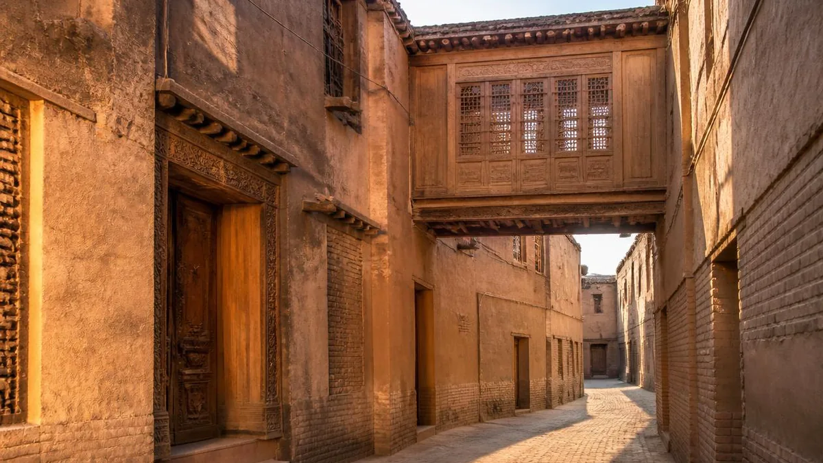
Now look up. When a family grew, it built: new rooms took part of the courtyard, then went up a storey, then ran out of plot—and so they crossed the lane.
Chinese descriptions name three results, and you can tell them apart on sight. A guojielou, an over-street room, spans the lane completely from an upper floor, leaving pedestrians a shaded tunnel below and the family a full room above. A banjielou, a half-street room, takes only half the width. Deep in the maze a xuankonglou, a suspended room, sits over the crossing of two narrow alleys, so that from a distance it reads as a tower standing in the lane. None of these are decorative: they are floor area bought where there was none left, with shade thrown as a by-product.
Underfoot there is said to be a wayfinding code. The widely repeated rule is that hexagonal paving marks a lane that goes through, while rectangular paving marks a dead end.
Be honest about how firm that is. Accounts disagree on the non-through pattern—square, rectangular, or tiles laid transverse to your direction of travel. Sources also disagree on whether this is an old residents’ convention or wayfinding installed during the renovation. Treat the hexagon as the reliable half of the rule and verify the rest with an app or a resident.
Id Kah Mosque is the point the whole map radiates from
The Id Kah Mosque is the geometric origin of the old city, and its published history is an accretion rather than a single build.
The commonly given account has Saqsiz Mirza raising a prayer hall on the site in 1442, on ground earlier used as a cemetery, with expansions attributed to 1538, 1798—when a traveller’s remaining funds were reportedly used and the name Id Kah attached—1809, 1838 and 1872, when the gate tower took its present form. The complex is usually given as about 140 by 120 metres, some 16,800 square metres, making it the largest mosque in China by site area.
Figures diverge past that point. The outer hall is an open colonnade on some 140 carved wooden columns about seven metres tall, and stated capacity ranges from 10,000 to 20,000 depending on whether courtyards are counted. The site has been under national-level heritage protection since 2001.
The architecture is a genuine composite of Central Asian, West Asian and Chinese traditions, so look at column carving and gate proportion rather than only the façade. And arrangements for visiting and for worship here have changed over time and are reported differently by different sources—confirm the current rules onsite, and behave throughout as though you are in an active place of worship.
The trade streets are named after what they make
Kashgar’s craft geography is legible once you know the three main axes.
Ostangboyi Road, running roughly a kilometre beside the Id Kah Mosque, is the classic handicraft street: hundreds of workshops and stalls for embroidered caps, silverwork, turned wood, pottery, copper, instruments and knives. Kumdarwaza Road is the one usually translated as the artisans’ street, home to instrument-making families and the city’s largest copper-working dynasty. Areya Road is only about 600 metres long but strings five bazaars in sequence: flowerpots and pottery, kantuman farm blades and blacksmithing, woodwork, Uyghur medicine, and embroidered caps.
Kashgar-district material counts 47 recognised intangible-heritage inheritors in the old city across eight autonomous-region-level categories, and reports 63 shops transmitting traditional skills, of which 47 carry a heritage plaque.
Use your ears before your camera. Copper announces itself, a lathe hums, and a pottery workshop is silent so you find it by the drying racks. If you buy, ask whether this is the workshop that made the object—and remember that a working shop is somebody’s income and often somebody’s front room.
The rebuild, and the argument about it
Both accounts belong here, set side by side.
The Chinese official narrative runs as follows. After the 2008 Wenchuan earthquake, a comprehensive dangerous-housing programme for the old city was drafted and approved by central ministries in 2009; Kashgar sits in a seismically active region; a 2003 quake in the prefecture killed hundreds. Official reporting describes a five-year plan covering 28 zones, about 8.36 square kilometres and more than 220,000 residents, cumulative state investment of over 7 billion yuan from 2010, a repair-as-old principle and a one household, one design method—with reinforced structures said to reach seismic grade 8 and the works substantially complete by around 2017. UNESCO’s Beijing office is quoted in this account as assessing the works positively after a 2009 mission.
The account reported at the time by overseas media and heritage specialists differs in both figures and framing. The New York Times published To Protect an Ancient City, China Moves to Raze It in May 2009, citing officials to the effect that at least 85 percent of the district would be demolished. UNESCO’s cultural specialist in Beijing is quoted describing the scale of demolition as shocking and objecting that her mission had been used to imply endorsement—directly contradicting the official version of the same visit. Cultural heritage in Kashgar was later raised in the European Parliament, and the city has not appeared in China’s Silk Road World Heritage nominations.
Some facts are not in dispute. Over 4,700 homes were demolished in 2009 alone, and more than two-thirds of the centuries-old earthen houses were eventually replaced by new construction in traditional style, with plumbing, heating and electricity, government and residents sharing the cost. In March 2024 the regional legislature passed a Kashgar Ancient City Protection Regulation, effective 1 May 2024—Xinjiang’s first law written for a single historic city.
You do not have to arbitrate between the two accounts. You do have to stop assuming that an old-looking wall is old.
Gaotai: a cliff quarter that closed, then reopened as something else
At the northeast end of the old city, a loess bluff described as more than 40 metres high and over 800 metres long carries the quarter known in Chinese as Gaotai Minju, the high-terrace dwellings. Its Uyghur name, Koziqiya Beshi, means roughly the potters on the high cliff; the site is commonly credited with about 600 years of settlement across some 57,000 square metres.
Gaotai is where the old city’s vertical logic runs furthest, because the cliff let families build up and down. Accounts describe three storeys above the bluff and four below, reachable from the top or by internal stairs, the lowest rooms effectively cut into the earth. Over-street, half-street and suspended rooms cluster most densely here.
Then the timeline changes character. The quarter was closed from 2016, entered a protection and restoration project in 2021, and began trial reopening in June 2023 with a daily allocation of free passes. Reporting from that moment is honest and slightly melancholy: no permanent residents inside, restored shopfronts alongside unfinished sections, and a tenancy of cafés and photo studios interleaved with pottery and brick carving—one workshop described as several centuries old, with a seventh-generation inheritor still working in it.
Gaotai is now the best place in Kashgar to read how the construction system worked, and the worst place to look for the neighbourhood it used to be.
Plan for heat, dust and things that change
Published figures give Kashgar an annual mean around 11.7°C, a January mean near -5.2°C and a July mean near 25.5°C, with annual precipitation of roughly 60 to 70 millimetres against about 2,730 hours of sunshine.
May and September into October are the reliable windows. Spring in southern Xinjiang brings frequent gales, floating dust and sandstorms. Summer highs of 30 to 35°C are lower than Turpan’s but the sunshine is relentless; the advantage of an old city is that most of your route is shaded lane, not open ground. Winter is low-season, cheap and half-shuttered, with short daylight and the compensation of snow on the roofs. In any season plan for a 10 to 15°C daily swing and strong ultraviolet.
Confirm three things rather than assuming, because all three have moved. The east-gate opening ceremony is a scheduled performance of roughly twenty minutes, historically twice daily and adjusted by season; times quoted in travel writing are frequently stale. Admission to the district is free, but named courtyards, rooftops and studios charge separately. And which lanes and workshops are open varies with restoration works.
And since the district’s value is that people live in it: do not walk through an open gate uninvited, and do not treat a doorway as a set.
What is actually continuous here
Before you leave, pick a lane away from the main axes and stand still for five minutes near the end of the working day.
You will not be able to tell which walls are original. That is not a failure of attention but the honest condition of the place after the rebuild, and it is why authenticity here has to be asked about something other than masonry. What comes past you instead is a coppersmith closing a shutter, bread coming out of a tonur, children using a covered passage as a shortcut they know and you do not, and an old man walking a route he has walked for sixty years past a wall that is fifteen years old.
That is the thing to carry out of Kashgar. Two thousand years of use, most of the material replaced within living memory, and the occupancy unbroken—126,800 people still going home to a plan drawn by a caravan trade that ended when the sea routes opened. The walls turned over. The address did not.
The LoreLens app can help you identify over-street rooms, carved gates and workshop trades while explaining the earthen building system around them.
Location profile
Where it is

Frequently asked questions
Is Kashgar Old City authentic or a reconstruction?
Both, and the proportions are disputed. From 2009 a large seismic-reinforcement and dangerous-housing programme worked through the district; Chinese official accounts describe a house-by-house design method under a repair-as-old principle, with historically valuable dwellings reinforced in place. Overseas reporting from the same period cited officials putting demolition at around 85 percent of the old district, and heritage specialists described substantial loss. Independent counts converge on more than two-thirds of the centuries-old earthen houses being replaced by new buildings in traditional style. Treat any single wall as unverified: ask onsite interpretation whether you are looking at original fabric, a reinforced original, or a rebuild.
Do people still live in Kashgar Old City?
Yes, and that is the point of the place. The Xinjiang culture and tourism authority gives the scenic area as 4.25 square kilometres with roughly 126,800 residents, which works out near 30,000 people per square kilometre if both figures are read together. Entry to the open district is free because it is a functioning neighbourhood rather than a gated site. Individual courtyards, rooftops and photo studios may charge separately, and the balance of homes to businesses differs sharply between lanes.
Is Gaotai, the high-cliff quarter, open to visitors?
It reopened, but as a different kind of place. Gaotai—Koziqiya Beshi in Uyghur, roughly the potters on the high cliff—sits on a loess bluff described as over 40 metres high and more than 800 metres long. It was closed from 2016, entered a protection and restoration project from 2021, and began trial reopening in June 2023, initially with a daily allocation of free passes. Reports from the reopening describe no permanent residents inside, a mix of restored workshop and exhibition zones, and cafés, guesthouses and photo studios alongside pottery and brick-carving. Opening hours, ticketing and which sections are accessible have all changed more than once, so confirm on the day.
When is the best time to visit Kashgar Old City?
Published climate figures give Kashgar an annual mean near 11.7°C, a January mean around -5.2°C, a July mean around 25.5°C, and annual precipitation of roughly 60 to 70 millimetres against some 2,730 hours of sunshine. That combination means shoulder seasons work best: May, and September into October. Spring brings frequent wind, blowing dust and sandstorms in southern Xinjiang. Summer highs of 30 to 35°C are survivable in shaded lanes but punishing on open squares. Winter is quiet and cheap with short daylight and many closed shops. Expect a daily swing of 10 to 15°C in any season.
Sources and further reading
Background references for the history and place names in this guide. Opening hours, ticketing and access change often — always confirm with official local information before travelling.