Xinjiang · Bayingolin
Bosten Lake: The Lake That Renames a River
One river goes in, a differently named river comes out, and that single fact is why a lake in the driest corner of China is drinkable — plus why the title it is famous for needs three qualifiers.
5A View location, maps and nearby scenic areasMost lakes take a river and keep the name. Bosten Lake does something stranger: the Kaidu River flows into it from the northwest, and the water that leaves the southwestern corner is called the Konqi—the Peacock River. Same water, different name, one lake in between.
That is not a naming quirk. It is the entire reason a large lake in the northeastern corner of the Tarim Basin, in Bohu County of the Bayingolin Mongol Autonomous Prefecture, is fresh at all. Everything around it is salt. The difference is that this lake has a drain.
One river in, another river out
The lake sits in the southeastern Yanqi Basin on the southern slope of the Tian Shan, at a surface elevation of about 1,048 metres. The Kaidu arrives after a long descent from the Bayanbulak grassland, where its meanders are the region’s other famous sight; sources give the river a length between 500-odd and 610 kilometres and a total fall of about 1,750 metres.
Its dominance as a water source is agreed on in substance and disputed in detail. English references put the Kaidu at about 83% of inflow; Chinese sources say over 86%; at least one account claims 95%. Smaller contributors—the Huangshui Gou, the Qingshui and the Wulasitai—make up the rest.
The balance sheet is lopsided. Long-term averages give roughly 2.68 billion cubic metres flowing in each year and about 1.25 billion flowing out through the Konqi. Everything else leaves as vapour, which is where the real problem starts.
Locally the lake is called the tailwater of the Kaidu and the source of the Konqi at once—a river’s ending and a river’s beginning in one body of water.
Three qualifiers hide inside the famous title
Bosten’s headline claim is that it is China’s largest inland freshwater lake. That is defensible, but only because three separate words are excluding three larger lakes.
Inland means endorheic—water that never reaches an ocean. That removes Poyang, China’s largest freshwater lake at roughly 3,583 square kilometres, which drains to the Yangtze and out to sea.
Freshwater removes Qinghai Lake, the country’s largest lake at about 4,543 square kilometres, which is endorheic but saline, along with the big Tibetan lakes.
Wholly domestic and endorheic removes Khanka, also called Xingkai—larger than Bosten and fresh, but a China–Russia border lake with roughly a third of its water on the Chinese side, and part of the Ussuri–Amur system that reaches the Pacific.
What is left is Bosten. It is not China’s largest lake and not its largest freshwater lake; it is the winner of a stacked definition. And more careful Chinese sources add a fourth word: largest inland freshwater through-flow lake, which is the honest version because it names the mechanism.
Swallow and spit
The Chinese term is tuntu—swallow and spit. It is the least poetic and most useful phrase in this article.
Arid-zone lakes go salty by simple accounting. Inflow carries a small dissolved salt load; evaporation—here estimated at 1,800 to 2,000 millimetres a year against very little rain—removes the water and leaves the salt. Run that long enough with no outlet and you get Qinghai Lake, or Lop Nur, or nothing.
A through-flow lake escapes the arithmetic because salt leaves with the outflow. Bosten stays fresh, or nearly fresh, only for as long as the Konqi keeps carrying water away.
That reframes what looks like ordinary infrastructure. When falling levels made gravity outflow unreliable, a pumping station and conveyance canal were built in 1982–1983, with an eastern station added in 2008, together lifting roughly 1 billion cubic metres a year into two channels feeding the Konqi—about 0.25 billion via the Kuta canal to the Qiala irrigation district. Those pumps are not only serving farms downstream; they are why the lake behind them is still classed as fresh.
The salinity record, 1958 to now
The numbers here are well documented, and they tell an uncomfortable story with a partial recovery.
The earliest measurement comes from a 1958 Chinese Academy of Sciences expedition: average mineralisation 0.386 g/L. Many researchers, reconciling later monitoring, now prefer roughly 0.6 g/L for that year. Either way, unambiguously fresh.
From the 1960s, growing industrial and agricultural demand around Korla required larger annual discharges from the lake. The level fell, the surface shrank, and concentration rose. By 1987 mineralisation had reached about 1.87 g/L, and the lake had become a brackish body. Native fish stocks declined alongside it.
Then a counterintuitive correction. The Jiefang No. 1 canal, which sent lake water directly into the Konqi, actually accelerated salinisation; discontinuing it after 1982 and switching to pumped conveyance from 1983 both increased throughput and lowered the mineralisation of water entering the lake. Concentration has trended downward since 1987. Current reporting puts it around 1.3 g/L.
Against the standard thresholds—under 1 g/L fresh, 1 to 35 saline—the lake sits on the wrong side of its own title. Shoreline industrial and agricultural discharge and eutrophication are documented alongside it.
The Tarim’s emergency tap
The Tarim River after the 1950s is usually described as four sources and one main stem: the Aksu, the Hotan, the Yarkant, and the Kaidu–Konqi. The last of those is this lake.
The downstream history is worth stating plainly. The Konqi, once given as 942 kilometres, was shortened to somewhere over 520. Lop Nur dried out—by 1964 in one account, completely by 1972 in another. The Daxihaizi reservoir, built in 1972, cut supply below it, and a stretch of channel commonly given as 320 to 363 kilometres went dry, taking with it much of the poplar and tamarisk belt known as the Green Corridor. The terminal Taitema Lake dried up too.
Two consecutive high-inflow years on the Kaidu in 1999 and 2000 left Bosten well above normal, and emergency transfers began. A Chinese account gives four transfers between May 2000 and October 2002 totalling 1.78 billion cubic metres, with the dry lower Tarim beginning to recover. An English-language account gives 1.30 billion cubic metres pumped from the lake between 2000 and 2006. The windows differ and the figures are not reconciled.
The constraint is the part travel writing usually leaves out. Research finds that when Kaidu runoff drops below roughly 3.58 billion cubic metres a year, there is not enough water to run transfers while also meeting human demand and holding the lake’s water quality—and that if the level ever fell to about 1,045 metres, transfers to the Konqi would become impossible. This lake cannot be both a reservoir for the Tarim and a stable freshwater body in every year. That is a genuine allocation problem, not a villain.
A level that has gone down, up, down and up
Read the water level as a saw, not a slope.
One reconstruction runs: 1048.00 m in 1958 declining to 1045.03 m by 1987 during a dry run on the Kaidu; a wet phase from 1988 lifting it to 1048.60 m by 2002; then a fall from 1048.55 m in 2003 to 1045.68 m by 2012 as inflow dropped and withdrawals grew. Analyses covering 1960 to 2018 attribute the 2003–2014 decline to reduced inflow plus increased outflow, and the 2015–2018 recovery to greater inflow plus strict control of outflow.
Not every series agrees. A Chinese Academy of Sciences researcher writing during the low point gave 1049.39 m for 2002 falling to 1046.62 m by 2006, warning the lake was near a critical minimum. That is close to a metre off the other reconstruction for 2002. Take the shape of the curve, not the decimals.
The surface responds violently because the lake is shallow. By 2014, local environmental officials described the surface as more than 400 square kilometres smaller than a decade earlier and 4.39 metres lower—about a third of the lake gone.
A shallow lake in a sinking basin
The geology explains the sensitivity. Bosten occupies an intermontane fault-subsidence basin within the South Tian Shan orogen, with a structural history traced back to the Pre-Sinian, and lake formation attributed to neotectonic differential movement from roughly 2.5 million years ago, when an older fault on the southern margin and a newer one on the northern margin framed a strongly subsiding block.
The result is wide and thin. Maximum length is about 55 kilometres and width 25; mean depth is given as 8.1 to 9 metres and maximum depth as 17; volume appears as about 8.15 billion cubic metres; the catchment as 56,000 square kilometres.
Surface area is the messiest figure of all: 1,000 square kilometres counting adjacent small lakes, 1,100 in one infobox, 1,160 in the body of the same reference, 1,228 in an older account, and 1,646 cited both as the historical maximum extent and, elsewhere, as a figure for around 2020. Never quote it without a year.
Structurally the lake is two things. The big lake is close to 1,000 square kilometres of open water. Southwest of it lies a small-lake district—dozens of separate lakes and channels, given variously as 100-odd, 240 or over 300 square kilometres, with a maximum depth of 16 metres and shallows of 0.8 to 2 metres. That shallow half is where almost everything alive happens.
Reeds are the crop, the filter and the nursery
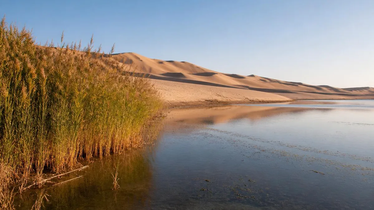
Reed beds around the small lakes and along the Konqi are not incidental scenery. They are an industry and a water treatment system at once.
Extent is disputed by nearly a factor of two: one figure gives 400,000 mu, roughly 27,000 hectares, another over 600,000 mu, roughly 40,000 hectares, with annual dry reed output around 400,000 tonnes. The stands themselves are unusual—more than 50 stems per square metre, typically over 4 metres tall and reported up to 6 to 8, which is why Bosten is counted among China’s four major reed-producing regions. The lake was added to Xinjiang’s first list of important wetlands in 2021.
Locals describe it as a loop—reeds protect the water, water raises fish, fish support tourism—and the ecology under the slogan is real: reed beds are spawning and nursery habitat, and fish metabolism returns nutrients to the reeds.
The other plant worth going for is the water lily around Lianhua Lake and Ahongkou, described as China’s largest naturally growing stand, in water 0.8 to 1.2 metres deep, flowering white and yellow in summer. The bird list runs to egrets, gulls, white storks and cormorants—more than ten migratory species, with counts reported in the ten thousands.
The fish that were here, and the fish that replaced them
Bosten has been a fishery for as long as anyone has written about it. The Book of Sui records the lake’s profit in “fish, salt, rush and reed.” The Book of Han describes the state of Yanqi as being “near a sea, whose water has many fish.”
What changed is which fish. Until the early 1970s, two native cyprinids made up about 80% of the annual catch: the Tarim schizothoracin (Schizothorax biddulphi) and Aspiorhynchus laticeps, the big-head fish, endemic to Bosten Lake and the Yarkand River. Between 1962 and 1965, bighead, black, silver, grass, common and crucian carp were introduced; by the 1970s they were the main targets. Since 1978 the introduced European perch—known locally as wudaohei, “five black stripes”—has dominated the catch.
Species counts conflict: some accounts give over 20 species plus shrimp, crab and mussels, others 32, with annual output around 2,500 tonnes.
Set that beside the salinity curve and the sequence is legible without anyone having to editorialise. The rise in mineralisation from the 1960s coincides with the decline of the two endemics that had defined the fishery, and their replacement by stocked and introduced species that tolerate the new conditions. The lake is still productive. It is producing different animals.
Four zones, an older name, and what to confirm at the gate
The scenic area became a national 5A site in May 2014—Xinjiang’s eighth and the prefecture’s first—having been designated a national key scenic area in the early 2000s, with 2002 and 2004 both cited.
It is usually described in four clusters. The Gold and Silver Beaches are where dune and water meet directly. Dahekou, the West Sea Fishing Village, sits about 12 kilometres from Bohu county town at the lake’s main inflow, holds what is described as northwest China’s largest inland fishing harbour, and is the start of the lakeside road and the venue for the spring lake-opening and dragon boat events. Ahongkou and Lianhua Lake lie in the southwestern small-lake district, about 42 kilometres from Korla, developed from 1997—winding channels, reeds and lilies, which is why the local nickname is a Jiangnan comparison rather than a desert one. The pumping station and Bailuzhou occupy the southern shore, open water in front, desert behind.
The names go back much further than the zones. Old Chinese sources call it Xihai, the western sea—a name also used for Qinghai Lake, so context matters. The Tang called it Yuhai, the fish sea. Li Daoyuan’s Commentary on the Waterways Classic calls it Dunhong Pu, and the Classic of Mountains and Seas refers to the waters of Dunhong, identified with this lake and the Konqi. “Bosten” was fixed as the name in the Qing. Its meaning is contested: Mongolian for “standing,” reportedly from three hills rising in the lake, or Uyghur for “oasis.” The Kaidu, for its part, is one of several rivers claimed as the Journey to the West Tongtian River—folklore, not geography.
One closing note follows from all of that. This is a lake whose surface has moved by four metres and several hundred square kilometres within living memory, and whose outflow is actively pumped. Which zones are open, which boats run, where the shoreline currently is, and what any of it costs are all functions of this year’s water. Confirm them at the gate rather than from an itinerary written earlier—including this one.
Location profile
Where it is

Frequently asked questions
Is Bosten Lake really China's largest inland freshwater lake?
It is, under a title with three qualifiers doing the work. Inland means endorheic—water that never reaches the sea—which removes Poyang, China's largest freshwater lake at about 3,583 square kilometres, because it drains to the Yangtze. Freshwater removes Qinghai Lake, the country's largest lake at roughly 4,543 square kilometres, because it is saline, along with Nam Co and Selin Co. Wholly domestic and endorheic removes Khanka (Xingkai), which is larger and fresh but is a China-Russia border lake with only about a third on the Chinese side and drains via the Ussuri to the sea. Bosten wins by elimination. One further honesty note: the freshwater half of the title is itself marginal now, with mineralisation reported around 1.3 g/L against a conventional 1 g/L threshold, so the phrase is partly historical.
How is Bosten Lake connected to the Tarim River?
It is one of the Tarim's four source systems. The Kaidu River flows in from the northwest, the lake acts as a natural reservoir, and the outflow leaves the southwest as the Konqi—the Peacock River—heading toward the Tarim. That makes the lake an emergency tap. Between 2000 and 2002 four transfers were run to the parched lower Tarim, with one Chinese account totalling 1.78 billion cubic metres and reviving 320 kilometres of dry channel, while an English-language account gives 1.30 billion cubic metres pumped between 2000 and 2006; the two figures cover different windows and are not reconciled. Research also sets limits: when Kaidu runoff falls below roughly 3.58 billion cubic metres a year, transfers start competing with the lake's own water quality and the Konqi basin's demand.
Is Bosten Lake getting saltier?
It got much saltier, then partly recovered, and it is not fresh by the strict definition today. The earliest measurement, from a 1958 Chinese Academy of Sciences expedition, gives an average of 0.386 g/L, though many researchers now prefer roughly 0.6 g/L for that year. From the 1960s, rising industrial and agricultural demand around Korla pushed more water out of the lake, the level fell, the surface shrank, and mineralisation climbed to about 1.87 g/L by 1987. Two engineering changes helped reverse it: the Jiefang No. 1 canal, which drained directly to the Konqi and worsened the concentration, was discontinued after 1982, and pumping stations took over from 1983. Mineralisation has trended down since 1987 and is currently reported around 1.3 g/L—above the 1 g/L freshwater line, so technically brackish.
What is there to see at Bosten Lake, and when?
The scenic area is usually described in four clusters rather than one viewpoint: the Gold and Silver Beaches where desert meets water; Dahekou, the West Sea Fishing Village, about 12 kilometres from Bohu county town and the start of the lakeside road; Ahongkou and Lianhua Lake in the southwestern small-lake district, which holds reed channels and what is described as China's largest naturally growing stand of water lilies in water 0.8 to 1.2 metres deep; and the pumping station with Bailuzhou on the southern shore, with desert immediately behind. Summer gives green reeds and lilies in flower, autumn gives golden reed leaves and white plumes. Because water level, open zones, boat operations and ticketing all vary by year and season here, confirm what is actually running at the gate on the day.
Sources and further reading
Background references for the history and place names in this guide. Opening hours, ticketing and access change often — always confirm with official local information before travelling.