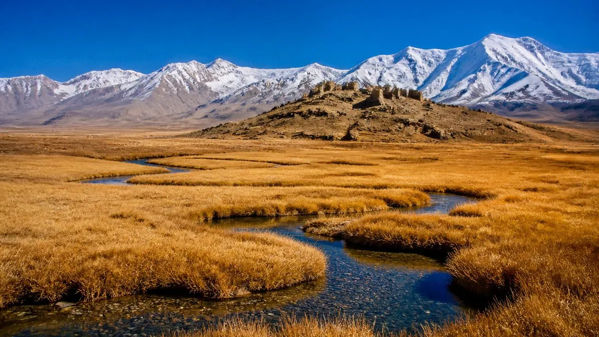
Xinjiang · Pamir
Pamir Tourist Area: 3.1 Square Kilometres and the Road In
A national 5A scenic area smaller than most city parks, built around a ruined mound and a marsh at 3,100 metres—plus the altitude, the permit and the duplicate lake name that decide how the trip actually goes.
5A View location, maps and nearby scenic areasThe Pamir Tourist Area is smaller than its name. The scenic area confirmed as national 5A in January 2020 has a total planning area of 3.1 square kilometres, all of it within sight of the county seat of Tashkurgan Tajik Autonomous County.
It does not contain Muztagh Ata. It does not contain Karakul Lake. It does not contain the Baisha Lake photographed with a white sand mountain behind it—that one is in a different prefecture.
What it does contain is a mound with a ruined city on it, a marsh at around 3,100 metres, a folk village and a heritage display zone. What surrounds it is the highest highway corridor most travellers will ever drive, and a border you have to apply for in advance. Read the gap between those two things and the place makes sense.
What the 5A actually covers, and what it does not
Start with the boundary, because almost every itinerary blurs it. The Ministry of Culture and Tourism confirmed the Kashgar Prefecture Pamir Tourist Area as national 5A on 7 January 2020, the prefecture’s third. It runs as a closed site: buy at the visitor centre, then ride a shuttle loop between components.
Even the component list is unstable. The Xinjiang culture and tourism authority names five zones—a Stone City area, Jincaotan, a Tajik folk village, a service centre and a shopping centre; encyclopaedic Chinese accounts also give five but swap the shopping centre for an intangible-heritage display area. The site was assembled from separate assets: county records describe the 3.1-square-kilometre package being defined around 2014 on the Stone City, the wetland park and a folk village.
What sits outside the line matters more. Muztagh Ata, Karakul Lake and the White Sand Mountain and its lake all lie in Akto County, in Kizilsu Kirghiz Autonomous Prefecture, with their own 3A ratings. On your road, not on your ticket.
”Pamir” is a landform word before it is a slogan
Signage will tell you that Pamir means “roof of the world.” That translates a real phrase, but the chain is worth knowing because it changes what the word points at.
The phrase is Bam-i-Dunya, recorded as a local expression by the British traveller John Wood in the 1830s and in general Victorian use for the Pamirs. Then it drifted—today it attaches more often to the Tibetan Plateau or Everest.
More useful is that pamir is a landform term: geographers use it for a flat, undulating high plateau or U-shaped valley ringed by mountains, the floor left behind when an ice field melts off.
The region also has a name for its shape rather than its height—the Pamir Knot, the uplift from which the Hindu Kush, Karakoram, Kunlun and Tian Shan all radiate. One name is a metaphor about altitude, the other about convergence. The second explains why anyone came here.
A mound with several kingdom names stacked on it
The Stone City—Shitoucheng, and Tashkurgan itself means stone fortress in Turkic—stands on an isolated rise above the left bank of the Tashkurgan River at the edge of town. Published descriptions give a roughly oval circuit of sun-dried brick and stone on a mound about 20 metres high, walls surviving to about 6 metres, a circumference near 1,285 metres and a site area over 100,000 square metres. Inner walls and corner towers largely stand; palaces have collapsed. It became an autonomous-region protected site in 1990 and a national key heritage unit on 25 June 2001.
The history under it is layered, and Chinese and English accounts stack the layers differently. Both agree that some two thousand years ago this was the centre of the Han-period Kingdom of Puli, recorded in the Book of Han and Book of the Later Han among the thirty-six states of the Western Regions, and that the site was later the seat of a Sarikol kingdom and then of the polity transliterated variously as Qiepantuo, Kabhandha or Kie-p’an-t’o, with an envoy recorded around 650 CE.
Where they part is tidiness. Chinese tourism material often simply equates Puli with Qiepantuo, as if one name replaced another on the same door; English scholarship treats them as successive and not necessarily continuous polities centuries apart. Take the sequence as real and the equals sign as convenient.
One identification stays unsettled: some scholars read the site as Ptolemy’s Stone Tower, the notional midpoint between Europe and China, and others reject it. It remains one of four candidates.
Why the southern Silk Road had to bend through here
Caravan roads converged on this basin from four directions: north to Kashgar, east to Kargilik and Yecheng on the southern rim of the Tarim, west to Badakhshan and the Wakhan, southwest toward Chitral and Hunza. Anything moving between the Tarim oases and the Oxus drainage had to cross the Pamirs, and the passable crossings funnel through a handful of valleys. Aurel Stein, who surveyed here early in the twentieth century and published in Serindia in 1921, concluded that the fort had been central to the whole Sarikol region, controlling routes from the Oxus to the oases of southern Turkestan.
The pilgrim record backs that up, with the usual caveat about dates. Faxian recorded a cold country where only wheat ripened and over a thousand monks lived; Song Yun passed around 500 CE; Xuanzang came through returning from India—commonly placed around 649 CE, local tradition giving 644 and a stay of twenty-two days—and described a capital on a great rocky crag, backed by a river. Chinese copy compresses this into “Xuanzang’s first stop on the journey east,” a claim about itinerary rather than a citation.
The modern layer is the same corridor with asphalt on it: the Karakoram Highway runs roughly 230 kilometres south from Kashgar to Tashkurgan and on to the Khunjerab crossing, making this a through route again rather than a dead end.
Jincaotan: a marsh that turns gold, and the river under it
Jincaotan—golden grass flats—is the component most people underrate, and the one with a mechanism behind it. Its formal identity is the Xinjiang Pamir Plateau Aral National Wetland Park, the name using the Turkic word for a river island—which is what a braided valley floor produces. Official descriptions class it as marshy meadow at about 3,100 metres, area commonly given as around 100,000 mu, roughly 6,700 hectares. The seasonal script is simple: green meadow in summer, vegetation yellowing in autumn until low sun gilds the basin—hence the name—and snow in winter.
The water is the interesting part. Through the middle runs the Tashkurgan River, described locally as the county’s mother river: it rises near the China–Afghanistan frontier, runs about 298 kilometres, and joins the Yarkand River at Lianghekou as its main tributary. That puts this marsh at the top of a chain that ends, a thousand kilometres downstream, in the desert poplar forests of the Yarkand’s alluvial fan and the oases irrigated beside them. The gold is a by-product.
”Tajik” here is an ethnonym over a different language family
China’s Tajik nationality—one of the 56 recognised nationalities—is an umbrella category, and most of the people it covers are not the Persian-speaking Tajiks of Tajikistan. The majority speak Sarikoli, a minority Wakhi. Both are Iranian languages, conventionally classified within the Pamir grouping of Eastern Iranian—a different branch from Persian, which is West Iranian. Neither has an official written form, so both are carried in speech. One small group, the Tor Tajiks, are Iranian in ancestry but speak a Turkic variety.
The numbers are modest and rising: about 41,028 in Xinjiang in 2000 and about 50,265 in 2015, with roughly 60 percent in Tashkurgan county. A 1997 administrative source put Tajiks at 50.1 percent of Tashkurgan town. Religiously the community follows Nizari Ismailism within Shia Islam; accounts of how religious life here is currently administered vary and have changed, so read current sources rather than a guidebook.
The upshot is small and real: the everyday language here is neither Uyghur nor Mandarin, and it has no script.
What is actually being done in the heritage zone
Some of what you see here is documented craft and some is stage. Four Tajik traditions can be pinned to the national intangible-heritage lists with batch and number. The eagle dance entered the first batch on 20 May 2006 as III-41, and the water-diverting and sowing festivals—the first known in Tajik as Ziwar, to lead water—the same batch as IX-28. Tajik wedding customs entered the second batch on 7 June 2008 as X-100, with music from eagle-bone flute and hand drum rather than large instruments, and both parties and their attendants painted with dozens of white dots for luck. Tajik dress is listed with Tashkurgan as the declaring county, the black lambskin tumak cap its most recognisable element.
Promotional copy routinely claims six national-level items here; four are verifiable by batch and code. The eagle-bone flute is sometimes counted separately and sometimes as part of the eagle dance, and folk song, horseback polo and yak-mounted goat-grabbing appear in some counts. Treat six as a marketing total.
The buildings are the part that cannot be staged. The village uses the Tajik house form Chinese sources call blankeli: low, thick-walled and inward-turned, with a skylit central hall—what a treeless plateau with a six-month cold season produces.
Altitude, season and the permit are one problem
Everything difficult about this trip is one fact wearing three costumes.
Altitude first. The town is given as about 3,090 to 3,094 metres, and the county mean is commonly quoted above 4,000 metres. Acute mountain sickness becomes a genuine risk well below the town’s figure, and the route from Kashgar—itself near 1,300 metres—gains most of the difference in one day’s drive. The mitigations are unglamorous: split the ascent, move slowly on day one, sleep low if you have the choice, and read headache and nausea as data. Bottled oxygen sells along the route for a few tens of yuan. Advice not to shower on your first day is custom rather than medicine, though the warning about getting chilled is sound.
Season second. Published figures for the town give a January daily mean near -11.9°C, a July mean near 16.4°C, an annual mean around 3.58°C and annual precipitation of roughly 68 to 85 millimetres. June through September is the practical window; the gold arrives in autumn. Winter closes roads.
The permit third. The county borders Pakistan, Afghanistan and Tajikistan, and Chinese guidance treats the whole corridor as border-management territory requiring a border-area permit checked with your ID, the destination named at county level. From 15 April 2026 it is reported to be issued electronically nationwide, paper issuance ended and existing paper permits valid until expiry. Accounts for non-mainland passport holders diverge.
One shortcut changes the arithmetic. Tashkurgan Hongqilafu Airport opened on 23 December 2022 at about 3,258 metres, Xinjiang’s first airport above the 2,438-metre extra-high-plateau threshold, cutting a drive of over 24 hours from Urumqi to roughly two hours in the air—which trades road time for a much faster altitude gain.
The road in: Muztagh Ata, Karakul, and a lake with a twin name
Most of what people remember happens on the highway, outside the boundary, so plan the drive as content rather than transit.
Muztagh Ata is the wall on your left. Its height is most often given as 7,546 metres, with 7,509, 7,545 and 7,549 also in circulation; its Turkic name is usually rendered father of ice mountains; it carries over ninety glaciers; the first ascent came in 1956, by a joint Chinese–Soviet party on the west ridge. Karakul Lake sits at its foot at about 3,600 metres in Akto County—a glacial-erosion and moraine-dammed lake whose name means black lake in Kyrgyz, depth usually given as about 30 metres. Area is where sources fight: tourism material says about 10 square kilometres, remote sensing comes out around 4.6. Take 10 as promotion.
Then the lake that causes the confusion. Beside the highway in Bulunkou township you pass a Baisha Lake—white sand lake—at around 3,300 metres, generally described as an impoundment tied to the Bulunkou reservoir, whose normal pool level is about 3,290 metres. Behind it stands Baisha Shan, a white quartz-sand mountain of relative height around 460 metres, most often explained as lake-bed sand exposed at low water and blown up the slope by wind funnelling through the Gez gorge; competing accounts have it weathered in place or imported from the Taklamakan.
This is not the Baisha Lake in the Altay. That one is roughly 1,200 kilometres north, at about 650 metres, ringed by dunes near the Kazakhstan border, with birch and poplar on its shore. Two lakes, one name, nothing else shared.
Before you leave, walk the wall
Climb the mound at the Stone City in the last hour of light and walk the surviving circuit instead of photographing it from the boardwalk.
From up there the whole argument of the place is visible at once. Below you the Tashkurgan River braids across the plateau floor into the marsh; beyond it the valley walls close into the passes that were the only way through; behind you the town, the airport and a highway still doing the job the mound was built to watch.
That is what to carry out of the Pamir. Not the altitude, which is only a number until it is a headache, and not the peaks, which belong to the next county. It is that a corridor with four exits collected a fort, several kingdom names, a pilgrim record, a customs post and finally a shuttle bus—same ground, same reason, two thousand years.
The mound never mattered because it was high. It mattered because it was in the way.
The LoreLens app can help you identify Tajik house forms, Stone City wall construction and plateau wetland plants while explaining the geography behind them.
Location profile
Where it is

Frequently asked questions
What does the Pamir Tourist Area actually include?
Less than most visitors assume. The scenic area confirmed as national 5A in January 2020 has a total planning area of 3.1 square kilometres, all of it beside the county seat of Tashkurgan Tajik Autonomous County. Zone lists differ slightly between sources: the Xinjiang culture and tourism authority names a Stone City area, Jincaotan, a Tajik folk village, a comprehensive service centre and a shopping centre, while encyclopaedic accounts substitute an intangible-heritage display area for the shopping centre. Either way the famous high-mountain sights on the drive up—Muztagh Ata, Karakul Lake, the White Sand Mountain and its lake—sit outside the boundary, in Akto County under a different prefecture, and carry their own separate 3A ratings.
Which Baisha Lake is on the road to Tashkurgan?
The southern one, and it is not the lake usually written up in English. On the Karakoram Highway you pass a Baisha Lake at roughly 3,300 metres in Bulunkou township, Akto County, in Kizilsu Kirghiz Autonomous Prefecture, generally described as an impoundment associated with the Bulunkou reservoir with a white quartz-sand mountain rising behind it. The other Baisha Lake is about 1,200 kilometres north: a small dune-ringed lake at around 650 metres in Habahe County, Altay Prefecture, close to the Kazakhstan border, with birch and poplar on its shore. They share a name and nothing else. If an article mentions Muztagh Ata, Karakul or Tashkurgan it is about the southern one; if it mentions the Irtysh, Kanas or the 185th Regiment, it is about the northern one.
How high is it, and what should I do about the altitude?
Tashkurgan town is usually given as about 3,090 to 3,094 metres, the Jincaotan wetland as around 3,100 metres, and the county mean is commonly quoted as above 4,000 metres because most of its area is mountain. Acute mountain sickness becomes a real risk for unacclimatised travellers well below these figures, so the standard advice applies: gain altitude gradually rather than driving straight up from Kashgar in one push, move slowly on the first day, keep the first night's exertion low, and treat headache, nausea or sleeplessness as signals rather than inconveniences. Bottled oxygen is widely sold at scenic areas along the route for a few tens of yuan. Local guidance also advises against showering on your first day at altitude—that is customary rather than clinical, but the underlying point about not getting chilled is sound. Anyone with heart or lung conditions, or who is pregnant, should take medical advice before committing.
Do I need a border permit, and when should I go?
Tashkurgan county sits against the borders of Pakistan, Afghanistan and Tajikistan, and Chinese travel guidance consistently lists the whole corridor—Tashkurgan, Karakul, the White Sand Mountain—as requiring a border-area permit checked alongside your ID. Guidance stresses naming the destination at county level. From 15 April 2026 the permit is reported to be issued electronically nationwide with paper issuance discontinued and existing paper permits valid until expiry; arrangements for non-mainland passport holders are described differently by different sources. For season, published climate figures for the town give a January daily mean near -11.9°C, a July mean near 16.4°C, an annual mean around 3.58°C and annual precipitation of roughly 68 to 85 millimetres. June to September is the workable window, with the marsh turning gold in autumn. Border rules, road openings and the Panlong road's seasonal closure all move, so confirm rather than assume.
Sources and further reading
Background references for the history and place names in this guide. Opening hours, ticketing and access change often — always confirm with official local information before travelling.