Xinjiang · Ili
Kalajun Grassland: An Old Flat Surface, Cut Open
A high meadow that is flat because it is ancient, canyons that appear underfoot with no warning, a flower field with a mechanism behind it, and a World Heritage boundary that is not the boundary on your ticket.
5A View location, maps and nearby scenic areasAt Kalajun the flat ground is the story, because it is older than almost everything around it and is being taken apart from underneath.
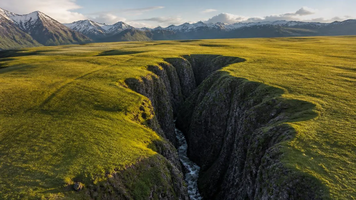
Ride out across the meadow in Tekes County, where the northern Tianshan slope steps down towards the Ili valley, and the ground is improbably level — a tilted plate of turf running to snow peaks. Then, with no warning and no change in the grass, it ends. A canyon several hundred metres deep is directly below you, and you can hear water in it.
That pairing — an intact flat top with deep gorges bitten into it — is one geological sequence, and it explains the flowers, the herding, and why the World Heritage boundary here is such a mess.
The flat part is the oldest part
The Tianshan has been built more than once. The standard account: the range was folded up in the Palaeozoic, then worn down through the Mesozoic and early Palaeogene until it was close to a peneplain — a low, near-featureless erosion surface. From the late Neogene onward that surface was broken along faults and lifted in stages, which is why the modern range carries stepped remnants of the old flat, known as planation surfaces.
Three are widely described in the Tianshan. Kalajun sits mainly on the third, according to China National Geography’s treatment of the area.
That inverts the intuitive reading. The meadow is not flat because sediment filled a basin, the way Bayanbulak’s floor is flat. It is flat because it is an inherited erosion surface carried upward more or less intact — an old landscape raised, not a new one built. A large level surface at this elevation holds precipitation instead of shedding it, develops deep soil, and grows continuous turf. Descriptions put the Kalajun block at roughly 2,000 to 2,800 metres, about 42 kilometres east to west and 25 wide.
Then the rivers cut down through it
Uplift has a second consequence: rivers that were meandering lazily across the old flat suddenly had gradient, and they took it.
The Kokesu river — glossed from Kyrgyz as the blue-green river — runs about 208 kilometres and joins the Tekes. Where it crosses the Kalajun block it has opened the Kokesu Grand Canyon, a V-shaped gorge cut into Cretaceous strata tilted during the Himalayan orogeny. Published figures give a rim near 2,170 metres, a floor near 1,810, and a maximum incision of about 360 metres. The north bank’s beds dip at 45 to 60 degrees; the south bank carries three river terraces.
Read those terraces. They are the same signal as the planation surfaces, one order of magnitude down: each is a floor the river held for a while before uplift forced it to cut again.
The most photographed reach is the nine bends, tight meanders on a wide canyon floor roughly 5,600 metres by 2,000. Those loops formed on a flat and were then let down into rock — entrenched meanders, a shape a river cannot cut downward from scratch.
The other gorge is the Kuerdai, over 50 kilometres of forested canyon averaging around 350 metres deep, separating Kalajun from Qiongkushitai to the south. A cable car crosses it.
Why so many species flower at the same time
Kalajun’s marketing term is the five-flower meadow, and unlike most such phrases it names a real ecological condition rather than a colour scheme.
The setting is a mesic subalpine meadow: the transition belt between the western Tianshan and the Ili valley, with high precipitation, cool summers and deep soil. Water is not the limiting resource. Time is. The ground is frozen for much of the year, so germination, growth, flowering and seed set compress into a few weeks, and species that would stagger their flowering across a long temperate spring have no room to. That overlap is the flower field.
Three mechanisms reinforce it.
Low stature. Cold and wind select for short, dense, sometimes cushion-forming plants, and short plants cast little shade — stripping tall grasses of the light competition that normally lets a handful of species dominate a meadow.
Scarce pollinators. With few insects and a narrow window, plants compete hard for attention, which is why subalpine flowers are conspicuously large and saturated relative to plant size.
Slow soil. Subalpine meadow soils are loose and rich in organic matter, with surface figures above ten percent reported, but cold soil mineralises slowly and available phosphorus is characteristically low. That caps any one species’ ability to run away with the sward.
Add moderate grazing, which crops the palatable dominant grasses first and opens niches for herbs, and coexistence is actively maintained.
What is actually in the sward, and when
Local material gives Kalajun 105 forage species with grass cover of 90 to 100 percent, and reports that FAO specialists surveying in the early 1980s rated it a first-class natural pasture.
One number does not fit. The same descriptions call the turf dense and low, then give a sward height of 65 to 100 centimetres. Those cannot both describe the same ground, so treat both as unreconciled.
The flowering sequence is better attested. May opens with rose-purple primrose, followed by globeflower, anemone, thyme, blue-flowered herbs, aconite and cranesbill, running a month or two. The regional calendar lists Kalajun specifically for white crocus, forget-me-not, snow primrose and marsh marigold — the last three all May and June. The broader rhythm is green in April and May, flowers in June and July, yellowing grass and reddening shrubs from August to October.
Advice on the peak conflicts: some guidance names late May to mid-June, other material June and July. Both circulate; neither is settled here. Individual species run only about seven to twenty days, so what you see is a sum, and the sum moves with the year.
The human-body grassland is a light effect with a naming problem
You will meet this phrase everywhere, and it needs unpicking on three counts.
It is not an official place. The scenic area’s own viewpoint lists for West Kalajun name other features entirely; the term circulates through photography communities and local usage.
Nobody agrees where it is. Most accounts put it in West Kalajun, next to the Kokesu canyon’s nine-bend reach; others inside the canyon sub-area, others again at Qiongkushitai. The canyon splits the grassland in two, so the nine bends and the smooth western slopes are sides of one place — but the disagreement is real.
It is an angle, not a landform. What people photograph is the eroded, gullied surface of the third planation level. The resemblance appears only when low late sunlight rakes across it and throws one flank into shadow. In flat midday light, under cloud, or once the grass has yellowed, it is not there.
There is also a cost. China National Geography reported that this was ordinary spring and summer pasture until recently, and that the horse-running now staged for photographers has worn thin tracks into the turf. The nickname is an observer’s projection. The erosion is not.
What the World Heritage inscription actually covers
Be careful here: the promotional language and the legal reality use similar words for different things.
Xinjiang Tianshan was inscribed in 2013 as a serial natural property with four components — Tomur in Wensu, Kalajun-Kuerdening in Tekes and Gongliu, Bayinbuluke in Hejing, Bogda around Fukang — totalling 606,833 hectares. UNESCO registers Kalajun-Kuerdening at 113,818 hectares of property with an 89,346-hectare buffer. Buffer totals for the whole property are inconsistent between sources: 491,103 hectares in some, 515,592 in others.
Two structural facts complicate the picture.
First, the component is in two pieces in two counties: Kalajun in Tekes, Kuerdening in Gongliu, over the mountains. The integrity statement notes that the components follow existing protected-area boundaries except here, where two parks were merged.
Second, the ticketed scenic area is a different polygon. The Kalajun ecotourism zone is usually given as 2,848 square kilometres, more than double the entire component — which itself includes Kuerdening, outside the Kalajun ticket. Other figures for the same scenic area, a planned 461.8 square kilometres with a 394.4-square-kilometre core, do not reconcile with the 2,848 either.
Neither boundary contains the other. And the integrity statement describes a property with no permanent residents, no extractive industry and no infrastructure construction — which cannot describe a shuttle circuit with boardwalks, a cable car and grazing families on it. Xinjiang’s 2011 heritage regulations require each component plan to designate no-build, restricted-build and display zones, and Kalajun is reported as zoned that way.
What we could not establish is which parts of the circuit sit inside the property, which in the buffer, and which outside both. Copy calling the Kokesu canyon a core part of the Kalajun World Heritage scenic area does not answer that. Read the gate sign as a claim about the region.
Kuerdening, the other half of the same component
The half nobody visits is arguably the reason the component was inscribed.
Kuerdening lies in Gongliu County, in a valley on the northern slope of the Nalati mountains. The name is glossed locally as the cross gully, because it runs north to south while its neighbours run east to west. The valley is about 14 kilometres long and up to a kilometre wide, with a floor near 1,500 metres, under Kaban Bayi peak at 4,257 metres.
That orientation makes it the wettest place in the range — the largest precipitation centre of the Tianshan’s so-called wet island — and it carries the densest Schrenk spruce forest in the mountains, with around 1,594 wild plant species recorded. It became a regional spruce reserve in 1984 and a national reserve around the turn of the century, sources giving both 2000 and 2004.
It is also a refugium: a Palaeogene shelter for relict species, holding 52 wild fruit tree species and Tertiary survivors including Junggar hawthorn, Tianshan maple and cherry plum, and claimed as the origin area of wild European plum. Figures for the component run to 2,622 vascular plants and 550 vertebrates, 94 of the plants pre-Quaternary relicts. That argument — a wild fruit gene pool and the heartland of Schrenk spruce — is what assessors were looking at. The Kalajun flowers are the visible half of a case largely made elsewhere.
The summer pasture never stopped being a summer pasture
Kalajun’s second name is Khan Jailau, which parses in Kazakh as the ruler’s summer pasture, and it was Wusun summer ground long before that.
It still is. Kazakh vertical transhumance moves stock up to high summer pasture between roughly 2,000 and 3,500 metres around June and back down before the September cold, along routes worn in over generations. There is no fixed date — the move follows the snowline and the grass, and a slow spring pushes it back a week or two, as when the Altay moves were reported starting only on 10 June in 2024.
That system is visible from the circuit if you know what to look at. Yurts appear and disappear on the terraces above the Kokesu. Qiongkushitai, across the Kuerdai canyon — the name glossed as the big flat platform — is a working pastoral village, listed nationally as historic and the trailhead of the old Wusun road. The 90-odd kilometres of mountain road from Tekes take two and a half to three hours, and in season the delay is often a flock crossing.
The eagle-training ground at Lieyingtai, at the far end of the East Kalajun shuttle, belongs to that working culture rather than to a stage set, though what a day visitor sees is a performance of it. The animals here are inventory.
Tekes, the shuttles, and planning around light
You will almost certainly stage from Tekes, about 16 kilometres away, and the town deserves a correction. Its radial plan — eight streets of 1,200 metres running from a central square, four ring roads, a 64-hexagram layout across roughly eight square kilometres — is routinely credited to the Song-dynasty Daoist Qiu Chuji. It was not his. The town was surveyed in the late 1930s by Qiu Zongjun, the Ili garrison commissioner, and the street lines were ploughed in 1939. Its record for the largest eight-trigram town is a Shanghai Great World Guinness record, a Chinese body, not the British one.
For the scenic area: five sub-areas are described and three normally operate — the Kokesu canyon, West Kalajun and East Kalajun — linked by internal shuttles and the cable car. East Kalajun holds the flower meadow, the Flower Terrace (renamed after a 2009 film; its older name was Jiasagan), the planation-surface viewpoint and Lieyingtai.
Sequence by light, not by map. The east side rewards mid-morning to afternoon, when flowers are open and the canyon has light in it; the west side is a late-afternoon proposition. Fares, hours, cable-car status and last departures move between seasons and operators, so confirm them at the gate rather than from any itinerary — this one included.
Walk to the rim and look at both surfaces at once
Before you take the shuttle back, walk out to a point where the meadow simply stops.
You are standing on two landscapes at once. Under your feet is an erosion surface worn flat when this range was low, then lifted thousands of metres with its flatness intact — which is why there is enough level, water-holding ground to grow a hundred species of grass and herb in the same few weeks. Three hundred metres below is the answer to that uplift: a river that gained gradient and has been taking the surface apart ever since.
The flowers are the short-lived part, the canyon is the slow part, and the herding family whose animals graze behind you lives off the interval between them. That is more durable than a photograph of a hillside in raking light — which is, as it happens, a picture of the same old surface being worn away.
Location profile
Where it is

Frequently asked questions
Is Kalajun a UNESCO World Heritage site?
Partly, and the wording matters. Xinjiang Tianshan was inscribed in 2013 as a serial property with four components, and one of them is Kalajun-Kuerdening in Tekes and Gongliu counties, registered by UNESCO at 113,818 hectares of property with an 89,346-hectare buffer. But that component is in two pieces in two counties, and the ticketed scenic area is a different polygon: the Kalajun ecotourism zone is usually given as 2,848 square kilometres, more than double the entire component, while Kuerdening lies inside the component and outside the Kalajun ticket. Published tourism copy calls the Kokesu canyon a core part of the Kalajun World Heritage scenic area — note scenic area, not property. We could not find a public map settling which parts of the visitor circuit fall inside the inscribed property, inside its buffer, or outside both, so treat the gate sign as a claim about the region rather than about the ground under your feet.
Why do so many species flower at the same time at Kalajun?
Because the growing season is short enough to force them into the same weeks. This is a mesic subalpine meadow on a cool, well-watered platform with deep soil, so plants have water and nutrients but very little time; species that would spread their flowering across a long spring instead overlap. Three things reinforce the effect. Low stature, an adaptation to cold and wind, weakens the light competition that would otherwise let a few tall grasses shade everything out. Scarce pollinators select for large, vivid flowers relative to plant size. And subalpine meadow soils are high in organic matter but slow to release nutrients, particularly phosphorus, which keeps any single species from running away with the sward. Moderate grazing helps too, by cropping the palatable dominant grasses and leaving room for herbs.
Where is the human-body grassland, and will I actually see it?
It is a nickname, not an official place. It refers to the smoothly undulating eroded surface in the western part of Kalajun, where late low sunlight and shadow make the ridgelines read as a reclining figure. Sources place it inconsistently — most point to West Kalajun next to the Kokesu canyon's nine-bend reach, others to the canyon area itself or to Qiongkushitai — and the scenic area's official viewpoint lists do not include the name at all. The effect depends almost entirely on low-angle side light, so it is a late-afternoon phenomenon and it fails in flat light, overcast weather or after the grass has yellowed. China National Geography has also criticised the photography economy around it, reporting that horses run for photographers have cut visible tracks into the turf.
When should I go and how does the circuit work?
The green season runs roughly May to October, with the meadow greening in May, flowering across June and July and turning gold from August. Guidance on the peak conflicts: some sources name late May to mid-June, others June to July. The scenic area is usually described as five sub-areas of which three operate — the Kokesu Grand Canyon, West Kalajun and East Kalajun — linked by internal shuttles and a cable car across the Kuerdai canyon, and the east side is where the flower meadow, the Flower Terrace and the planation-surface viewpoint are. Ticket structure, shuttle fares, cable-car operation, last departures and whether horses can be hired all vary by season and operator, so confirm the current arrangement at the gate.
Sources and further reading
Background references for the history and place names in this guide. Opening hours, ticketing and access change often — always confirm with official local information before travelling.