Xinjiang · Altay
Baisha Lake: A Lake in a Dune Field, and Nobody Can Say Why
A half-square-kilometre lake ringed by sand 2.5 kilometres from Kazakhstan, with birch and poplar on its shore, no visible inlet or outlet, and a border that a flood once tried to move.
5A View location, maps and nearby scenic areasSearch for Baisha Lake and you get two lakes, and most of what you read is about the wrong one.
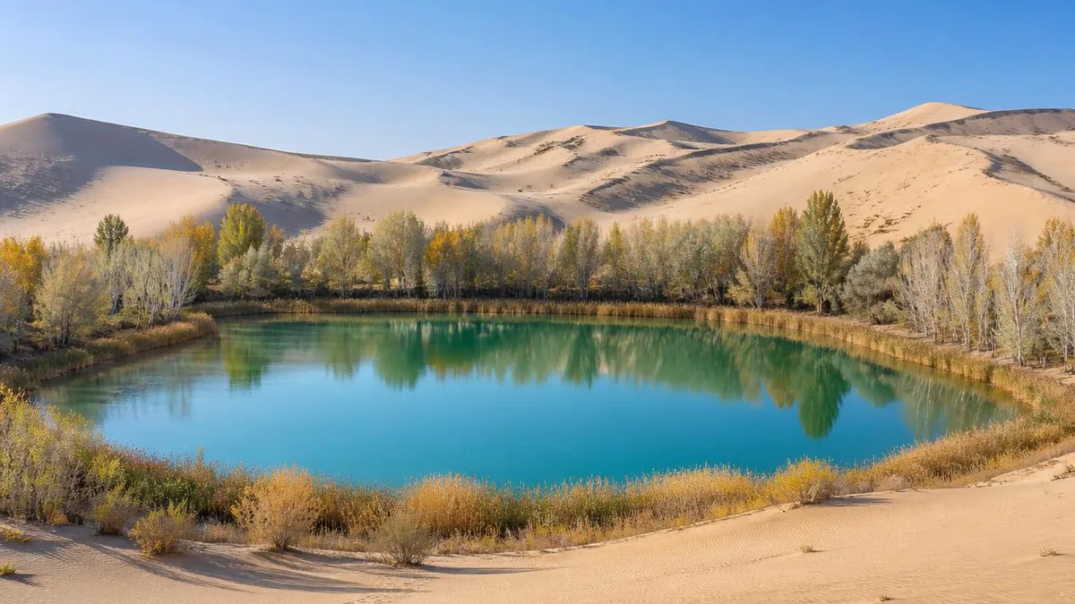
One sits at around 3,300 metres on the Pamir plateau in southern Xinjiang, under Muztagh Ata, with a white sand mountain behind it. The other sits at 650 metres in the far northwest of the Altay, 2.5 kilometres from Kazakhstan, ringed by dunes, with birch and poplar growing a rope’s length from the sand. They are roughly 1,200 kilometres apart. This article is about the second, at approximately 48.35 N, 85.75 E.
And the interesting thing about it is not the photograph. It is the plumbing. A lake in a dune field, no visible inlet, no visible outlet, in a district where evaporation runs eight to ten times annual rainfall. Something feeds it. Nobody has published a convincing measurement of what.
Which Baisha Lake this is, and whose
Get the address right, because almost every English page gets part of it wrong. The lake lies in the territory of the 3rd Company of the 185th Regiment, 10th Division of the Xinjiang Production and Construction Corps, inside Habahe County, Altay Prefecture. Not Burqin—though Burqin is the gateway most travellers use, which is how the error spreads. It became a national 5A scenic area on 25 February 2017, the Corps’ first, after entering the candidate list on a landscape-quality review in December 2015. English pages dating the rating to 2015 quote the review stage.
The internal geography comes in equal steps, which makes it easy to hold. From the regiment headquarters, 15 kilometres south is the point where the Irtysh River leaves China. 15 kilometres north is Mingsha Mountain. 15 kilometres further north is the 3rd Company, and the lake sits about 500 metres east of it among sand hills.
The regiment’s border with Kazakhstan runs 85.4 kilometres, bounded west and north by the Alqabek River and south by the Irtysh. A border unit that happens to contain a lake.
Two sets of numbers, and only one of them adds up
Altitude is the only figure everyone agrees on: 650 metres. After that, two incompatible descriptions circulate. The first gives roughly 800 metres north to south by 600 east to west, surface area 0.5 square kilometres, shaped like a pea pod. Multiply 0.8 by 0.6 and you get 0.48, which rounds to 0.5. That set is internally consistent.
The second gives 2,100 by 1,300 metres with a water surface of about 10 hectares. Those figures contradict each other: 2.1 by 1.3 kilometres is 2.7 square kilometres, or 270 hectares, not 10. One half of the pair is wrong, quite possibly both.
Depth is worse—no published figure exists. The nearest reference is a county survey noting that Habahe’s plains hold more than ten lakes totalling 1.73 square kilometres, at depths of 0.5 to 6 metres. When a caption calls this a deep pool in the desert, read it as rhetoric.
Where the water comes from, and who admits they do not know
Be sceptical of the claim itself, not just the explanations for it. The standard sentence, repeated by official media and every travel page, is that the lake has no inlet and no outlet and that its level neither rises nor falls with the season. The second half is a tourism sentence, not a gauge record: no public water-level series exists. “Never changes” probably means nobody watching casually noticed it change.
The underlying puzzle is real, though. Three mechanisms get proposed.
Lateral groundwater recharge is the popular-science favourite. Rainfall is scarce and evaporation fierce, so a persistent lake must be fed from below: a topographic low over a good aquifer collects seepage.
The snowmelt chain puts a source at the far end of that pipe. The Habahe river’s headwaters carry 35 glaciers over 31.26 square kilometres, and county hydrology describes plains groundwater as recharged mainly by rivers and irrigation, on the order of 65 million cubic metres a year.
A structural basin is the third: some English descriptions call it a fault lake fed by seepage, which would explain the hole as well as the water.
What is missing is evidence: no isotope tracing, no water-balance study, no borehole log in the open literature, and Chinese official sources say so directly. The one safe statement is that the lake must be in dynamic balance, recharge roughly equalling evaporation plus seepage. Which reservoir supplies it, and by what path, is unmeasured.
The dunes are downstream of a river
The sand deserves the same scepticism as the water. You will read that this is a freshwater lake on the northern edge of the Gurbantunggut, China’s second-largest desert. Check a map. The Gurbantunggut lies in the Junggar Basin, south of the Irtysh; the 185th Regiment is on the north bank. That phrase is a bearing, not an address, and the dunes here are not that desert.
What they are is local aeolian sand of the Altay plains, found in patches across Fuhai, southern Fuyun, and parts of Habahe, Burqin and Jeminay. The general mechanism—an analogy, not a study of this site—is that river terraces supply the raw sand and wind sorts and redeposits it downwind, making the Irtysh valley the plausible sand factory. Habahe’s prevailing wind is westerly, at 3.6 to 3.9 metres per second.
Mingsha Mountain, the dune group on the way in, is described as six sand ridges about 2 kilometres long and 100 to 200 metres wide, with a relative height of only 25 metres; one source puts summer midday sand temperatures at 40 to 60°C. The booming that names it is reported by visitors running down the steep face—an experience, not a measurement.
Three rings of vegetation in fifty metres
Look at the plants on site: they are the evidence. In the water, reeds and what tourism copy calls sweet flag grow 1 to 4 metres tall in dense stands. A fuller wetland list for the area gives reed, chee grass, long-bracted cattail, club-rushes and a sand sedge—so the brochures’ “sweet flag” is more likely the cattail, a loose usage in Chinese.
Within 50 metres of the shore, a tall dense belt of silver-grey poplar, white poplar and birch.
Beyond 50 metres, on the dunes, Irtysh poplar, hawthorn, poplar and spiraea, with creeping juniper in some accounts.
That zoning is the interesting fact, not the contrast photographs. Silver-grey poplar and birch are not desert plants; their presence a rope’s length from open dune means the water table is shallow at the shore and drops away fast behind it. The three rings are a map of the water table, drawn by the plants.
One claim to hold at arm’s length: a wild lotus is said to flower here each June, a line repeated everywhere without a botanical name attached. At 48 degrees north, in a dune lake, that deserves a raised eyebrow. Something aquatic very likely flowers in early summer; a water lily is the likelier identity, and nobody has checked.
The night a river tried to move the border
Two and a half kilometres northwest runs the Alqabek River, the reason this place is more than scenery.
It rises in East Kazakhstan and joins the Irtysh near the regiment’s 6th Company. Total length 95 kilometres, of which about 66 is boundary; basin area 998 square kilometres; flow fed chiefly by seasonal snowmelt.
On 23 April 1988 that snowmelt arrived as an extreme flood, breached the Sandeke control point, and the river began cutting a new channel inside Chinese territory. Because a boundary river’s channel defines the boundary, the calculated exposure was 55.5 square kilometres. Regiment staff, garrison troops and local officials worked 16 days and nights—stone fill, sandbags, wire gabions—and forced the water back into its old bed.
Afterwards the regiment posted a militia watchman at Sandeke permanently. Ma Junwu, nineteen at the time and a participant in the flood fight, took it; from 1992 his wife Zhang Zhengmei joined him. Two watchtowers over 20 metres stand there, and the duty log reportedly fills more than twenty notebooks. The local line: you can die four times a year here—flood in spring, insects in summer, blown sand in autumn, ice in winter.
The monument to that flood defence is on the same ticket as the lake.
The border is 2.5 kilometres away, and it is administered
This is the item that ruins trips, so settle it before you drive. Chinese travel guidance lists the 185th Regiment and Baisha Lake among places where a border-area permit is checked alongside your ID card, with checkpoints described as strictly enforced and people without one turned back.
The mechanism is reported to have changed. From 15 April 2026, China’s immigration administration is described as issuing the permit electronically nationwide and ending paper issuance, with paper permits already held valid until expiry. Application is online and free; at a checkpoint you show the permit, or a printout, with your ID. Guidance stresses naming the destination at county level—here, Habahe County, specifying the 185th Regiment Baisha Lake scenic area.
For non-mainland passport holders the accounts diverge. Some describe applying in person at a public-security exit–entry office in Urumqi or Kashgar with passport and visa, sometimes with a travel-agency letter; others say certain border villages here are closed to foreign nationals. Resolve that before booking.
The standing caveat applies with more force here than anywhere else in this series: border rules move with season and circumstance. Confirm with the scenic area, not an itinerary written last year.
What else is on the same ticket
The lake alone does not justify the drive. The border line does. The lake ticket reportedly also admits you to the regiment’s sites: Mingsha Mountain; the Northwest First Company, where a stone marker about 4 metres high carries the map of China under an inscription meaning “northwest of the northwest”; Eye Mountain, named for gnarled creeping pines read as a sentry’s eyes; the flood-defence monument; and the point where the Irtysh leaves China—the exit of the only river system in the country draining to the Arctic.
On-site logistics, as reported: gate to lakeside about 2 kilometres, walkable or by electric shuttle; a shoreline boardwalk of roughly 1 kilometre ending at a viewing platform; and a dune with a pavilion about 15 minutes up, from which you can look west into Kazakhstan.
Prices and hours need verifying. Admission is quoted at 40 to 45 yuan with a 10-yuan shuttle; older sources say 70. Hours appear as 09:30–19:30 in one place, 10:00–22:00 in another. Half a day covers the lake; a full day covers the border.
Where it fits in a Kanas circuit, and when
Nobody flies to Habahe for half a square kilometre of water. Almost everyone arrives with Kanas already on the itinerary, which makes sequencing the real decision.
The quoted distances: Burqin to Habahe town about 110 kilometres; Habahe to the lake about 70 by drive time, though other sources give 108 by road, so the route is not direct; Burqin to the lake about 160 kilometres, two and a half to three hours. Burqin to Jiadengyu at the Kanas gate is 148, and the lake to Baihaba village around 240 on mountain road.
The naive plan runs Burqin, out to Baisha Lake, back to Burqin, then up to Kanas—paying for the Habahe road twice. The better shape is Burqin, Habahe and Baisha Lake, then into Baihaba through the Tiereketi gate, then Kanas, Hemu, back to Burqin. Both sit in the border zone, so one permit covers the pair, and entering Baihaba from the Habahe side avoids doubling back from Kanas.
If Kanas is your only priority, the honest alternative is to skip the lake, or pair it with Wucaitan on one long day out of Burqin and accept that most of it is windscreen.
For timing, June to September is the usual recommendation—June for the flowering aquatics, October for foliage in the poplar and birch. Dawn and dusk are the light; still air gives a mirror. One contradiction to know: local copy insists the water never freezes and never clouds, while winters here are cold enough that any open water freezes hard. The poetry and the thermometer disagree, and the thermometer wins.
Before you leave, look for the inlet
Walk the boardwalk to the end and do the one thing no signboard asks: look for where the water comes in and where it goes out.
You will not find either. That absence is the actual attraction, and it beats the reflection. Everything visible here is downstream of something you cannot see: a snowmelt catchment out of sight, an aquifer under the dunes, a water table that surfaces at this point and nowhere else for kilometres around.
Which reframes the dunes. They are not a wall keeping the dryness out. They are the roof over the plumbing that keeps the water in—sand delivered by a river and sorted by wind, hiding the connection that makes the lake look impossible.
And 2.5 kilometres northwest, a river once spent sixteen nights trying to redraw the country. This is not a scenic lake with a border nearby. It is a border with a lake in it.
The LoreLens app can help you identify dune forms, riparian poplar and birch, and wetland plant zoning while explaining the hydrology behind them.
Location profile
Where it is

Frequently asked questions
There are two Baisha Lakes in Xinjiang. Which one is this?
This is the northern one: a small desert lake at about 650 metres in Habahe County, Altay Prefecture, roughly 48.35 N and 85.75 E, about 2.5 kilometres from the Kazakhstan border, ringed by dunes with poplar and birch on its shore. The other Baisha Lake sits at around 3,300 metres on the Pamir plateau in Akto County near Muztagh Ata, beside the Karakoram Highway, and is usually described as an impoundment associated with the Bulunkou reservoir with the White Sand Mountain rising behind it. They are roughly 1,200 kilometres apart and share nothing but a name. If an article mentions Pamir, Muztagh Ata, Tashkurgan or Karakul, it is about the southern one.
Why does the lake not dry up if it has no inlet or outlet?
Nobody has published a measurement. Official Chinese sources state openly that the water source and the origin of the lake remain unexplained. The most widely repeated hypothesis is lateral groundwater recharge: rainfall here is scarce and evaporation is roughly eight to ten times greater, so a lake that persists is being topped up from below, most likely from a snowmelt-fed aquifer connected to the surrounding river system. Some English descriptions call it a fault-basin lake fed by seepage. All of these are plausible mechanisms rather than measured findings, and no isotope study, water-balance calculation or borehole record for this specific lake appears in the open literature.
Do I need a border permit to visit?
The lake sits inside a border-management zone in the 185th Regiment area, and Chinese travel guidance consistently lists it among places where a border-area permit is checked alongside your ID card. Checkpoints are described as strictly enforced. From 15 April 2026 the permit is reported to be issued electronically nationwide with paper issuance discontinued, existing paper permits remaining valid until expiry. Rules for non-mainland passport holders differ between sources. Border rules change with season and circumstance, so confirm the current requirement with the scenic area before driving out.
When should I go, and how long does it take?
June to September is the usual recommendation, with flowering aquatics reported in June and poplar and birch colour in October. Dawn and dusk give the best light, and still air produces a mirror surface. Half a day covers the lake itself; a full day lets you add Mingsha Mountain, the Northwest First Company and the point where the Irtysh leaves China. Winter is cold enough that most itineraries avoid it—Habahe records extreme lows near minus 39°C—and shuttle and access arrangements change out of season.
Sources and further reading
Background references for the history and place names in this guide. Opening hours, ticketing and access change often — always confirm with official local information before travelling.