Beijing · Great Wall
Badaling or Mutianyu: Choose Your Great Wall
China's 5A list joins Badaling and Mutianyu under one name, but visitors must choose between two separate mountain sites. Compare their ridges, routes, crowds and practical trade-offs.
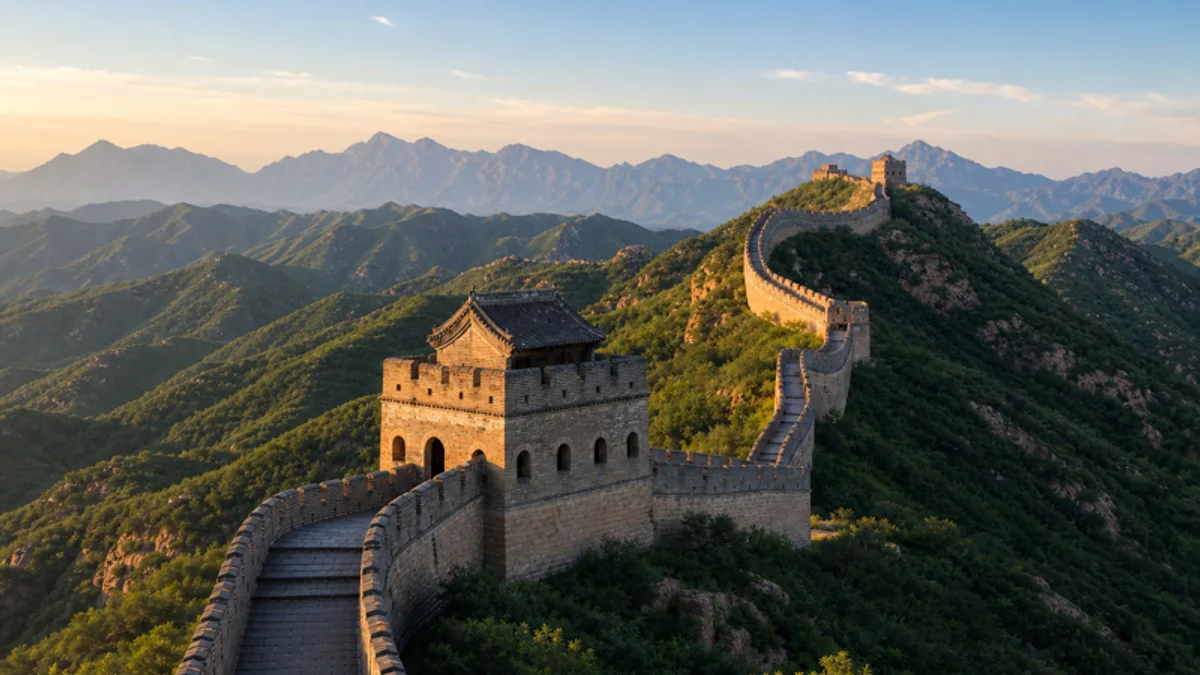
5A View location, maps and nearby scenic areasClimb onto a watchtower roofline at Badaling (roughly “bah-dah-ling”) or Mutianyu (“moo-tyen-yoo”) and look away from the nearest crowd. The wall drops into a saddle, rises sharply to the next tower, then disappears behind a mountain shoulder. What looks like one line is constantly being broken and remade by terrain.
Before interpreting that view, make one practical distinction. China’s official 5A list combines Badaling and Mutianyu Great Wall Tourist Area as a single rated unit. A visitor does not encounter one connected park. Badaling and Mutianyu are far apart, have independent approaches, entrances and ticket systems, and usually require a choice. There is no ordinary walking route that casually links them.
Choose by experience, not by ranking: Badaling offers the most instantly recognizable ridge and broader visitor infrastructure, often with heavier crowds. Mutianyu offers forested mountains and a dense rhythm of towers, often with more breathing room but no escape from steep ground. Neither is the universally “best” Great Wall.
One 5A name, two independent journeys
Badaling lies in Beijing’s Yanqing District, on the historic corridor northwest of the capital. Mutianyu lies in Huairou District, northeast of central Beijing. Their mountain settings, approach roads and visitor operations are separate. Being grouped in one national rating does not make admission interchangeable or the two entrances close.
The distinction matters at booking time. Search results and tour listings sometimes shorten both to “Beijing Great Wall,” leaving the actual section in small print. Confirm the site name, entrance, meeting point and return arrangement before paying. The Badaling 5A profile and Mutianyu 5A profile map the two locations separately.
A vehicle transfer between them is not the same as walking along the wall. Unrestored and restricted terrain lies between accessible tourist sections, and the road journey can consume a large part of a day. Unless a return visit or specialist itinerary gives you a reason to compare both, pick one and use the saved hours on the wall itself.
The Great Wall was never one wall built at one time
The name “Great Wall” gathers frontier works constructed, abandoned, rebuilt and connected by different states over many centuries. Earthen ramparts in some regions, stone barriers in mountain passes and the brick-faced ridges familiar around Beijing do not belong to one emperor’s single construction campaign.
The accessible walls at both Badaling and Mutianyu mainly present the Ming dynasty defence system. After the Ming took power in 1368, northern frontier strategy changed repeatedly. During the 15th and 16th centuries, walls, passes, forts, towers and garrisons around Beijing were strengthened in response to shifting military threats and political priorities.
Badaling’s surviving landscape is especially associated with the mature 16th-century defence of the route towards Beijing. Mutianyu’s visible line also largely reflects Ming construction and rebuilding, adapted to a steep chain of ridges. Modern restoration makes both sites safer and more legible, but it also means that not every brick surface is untouched Ming fabric.
Read the monument as a network, not an uninterrupted ribbon. Walls channel movement; passes control roads; towers extend sightlines; forts house troops and supplies; signals connect positions. In places, mountains did more defensive work than masonry.
What the wall was designed to make difficult
Stand inside a tower and look through openings in several directions. The useful unit is not the photographable tower alone but the relationship among tower, wall and slope. A patrol could watch approaches, shelter from weather and communicate along the ridge. Details of tower use varied by place and period, so avoid assigning every chamber one fixed function.
Battlements protected defenders while leaving observation and firing positions. Stepped paving kept a route across land far too steep for a level road. Drainage channels helped move rainwater away from surfaces. Gates and passes allowed controlled traffic in ordinary times but became points of concentrated defence during crisis.
The system was not an impenetrable border. Armies could attack gates, exploit weak stretches, use alternate routes, negotiate passage or benefit from political failure inside the defence. The wall worked alongside mounted patrols, intelligence, diplomacy, trade controls and local garrisons. It could delay, observe and channel; it could not make strategy unnecessary.
At one steep flight, turn around. Defenders had to carry food, weapons, fuel and repair material over the same terrain. The difficulty you feel as a visitor was an everyday logistics problem before it became a scenic achievement.
Badaling: the classic panorama and its crowd trade-off
Badaling delivers the image many visitors already carry in their minds: a restored wall running openly over rounded mountain ridges, with large towers visible in both directions. Its long history as a major visitor site has produced relatively broad transport and service choices. Some parts may offer more accessible arrangements than many other Great Wall sections, although current routes and assistance should always be confirmed.
From the main access area, visitors commonly choose between north and south routes. The north side is widely recognized and often draws the larger flow; its repeated climbs create the famous receding-wall panorama. The south can offer a different rhythm and may be quieter at some times, but “quiet” is never guaranteed, especially on weekends and holidays.
Do not judge a route only by its highest advertised tower. Irregular stairs, slopes and the return journey matter more than the number on a map. If visitor transport is operating, it can reduce part of the ascent but does not remove all steps or crowding. Check where any lift or cable service actually deposits you and how you will return.
Badaling is a strong choice when first-time recognition, organized access and a large-scale ridge view are priorities. Its disadvantage is the same fame that makes it easy to choose: bottlenecks can make the wall feel like a queue on stone. Arrive with a route plan, but be willing to stop short rather than pushing into a packed narrow section.
Mutianyu: towers, forest and more route combinations
At Mutianyu, the wall repeatedly dives into forest and climbs back onto exposed ridges. Towers appear at relatively close intervals, giving the walk a strong architectural rhythm. Seasonal foliage frames the masonry, though leaves, color, snow and visibility depend on weather and should never be promised for a date.
“Less crowded than Badaling” is a useful tendency, not a guarantee. Mutianyu can also be busy, particularly around transport terminals and popular towers. Once walkers spread in different directions, parts of the wall may feel more spacious. The ridgeline still includes steep slopes and uneven steps; a green mountain setting does not mean an easy trail.
Mutianyu offers several possible combinations of walking and mechanical ascent or descent. Depending on current operations, visitors may encounter a cable car, chairlift or toboggan-style slide. These services may have different boarding points, ticket products and operating conditions. Maintenance, wind, rain, ice, capacity and safety controls can close or limit them.
Choose the wall route first and the novelty ride second. Confirm which tower area a service reaches, whether tickets are one-way or return, and whether your descent choice leads to the exit you expect. A downhill slide can be memorable, but it is transport run under operating rules, not a guaranteed finale.
Soldiers, military households and communities behind the skyline
An emperor could order walls strengthened, but commands did not quarry stone, fire bricks or keep a winter watch. The Ming frontier depended on soldiers, officers, artisans, transport workers and military households connected to the weisuo garrison system. Nearby communities supplied food, animals, tools and knowledge of the landscape.
Their lives were not one simple category of “forced labour.” Construction and service conditions varied across time and place, and surviving records do not let every worker speak equally. Some people served through military obligation; others were craftsmen, convicts, corvée labourers or local suppliers. The human cost was real, but a responsible account resists inventing one universal story.
Look down from the ridge toward roads and cultivated valleys. A wall on the skyline depends on a much larger support landscape below: farms, storehouses, water sources, paths and settlements. Soldiers also lived through long periods when no battle occurred. Maintenance, drills, cold, boredom and the uncertainty of signals were as much a part of frontier life as combat.
The nearby Ming Tombs provide a revealing contrast. The emperors commemorated in a protected valley relied on frontier systems maintained by people who rarely received monuments of comparable scale.
Two myths that make the real wall harder to see
The first claim is that the Great Wall is the only human-made object visible from the Moon, or easily seen from space with the unaided eye. It is not. The wall is long but narrow and often close in color to the surrounding ground. From the Moon it cannot be picked out by unaided human vision; from low Earth orbit it can be difficult to distinguish even under favorable conditions. Length alone does not make a feature visually wide.
The second claim is that dead workers were routinely buried inside the wall, so bones form part of the structure. Archaeological evidence does not support this as a standard construction practice. Decomposing bodies would also create weakness rather than useful building material. People certainly died during harsh frontier construction and service, and burials may exist near work sites, but that is different from saying corpses were commonly built into masonry.
These myths survive because they compress enormous scale and suffering into memorable images. They are emotionally efficient and historically poor. The better human story is visible in supply routes, repaired brick, garrison remains and the sheer work of maintaining exposed kilometres of defence.
The Great Wall needs no view from the Moon and no invented skeletons to matter. Its real achievement—and its cost—are large enough on Earth.
Make the choice before you leave Beijing
Choose Badaling if you prioritize the iconic restored vista, a wider range of organized transport options or potentially more developed accessibility services. Accept that crowding can be substantial and that the most popular north route may be the busiest.
Choose Mutianyu if forested ridges, frequent towers and multiple route combinations matter more. Accept extra planning around transfers and mechanical transport, and remember that cable access does not eliminate steep wall sections.
For either site, check the official operating notice close to your visit. Real-name reservations, passport checks, shuttle arrangements, entrance locations, open towers and last transport times can change. Use the exact passport details supplied at booking, carry the original document and leave time for security or ticket problems. A tour should name the actual Great Wall section, not only promise “the Great Wall.”
If you are more interested in a fortified valley and a Yuan-dynasty multilingual monument than in these two ridge experiences, Juyongguan is a third, separate choice. It should not be confused with Badaling despite sharing the same northwest corridor.
Photograph ridges, respect weather and save energy to descend
For a readable photograph, include more than the nearest parapet. Use the wall’s S-curves to lead into distant towers, allow a person to provide scale, and leave enough landscape to show why defenders selected the ridge. A moderate telephoto lens compresses successive hills; a wide lens emphasizes the immediate climb.
Front light reveals brick and stone clearly. Side light models towers and slopes. Backlight can turn watchtowers into silhouettes and layer ridges in haze. None of these conditions is guaranteed. Fog may erase the long view; hard midday light may flatten it; strong wind can make exposed sections uncomfortable. Work with the mountain you receive.
Wear shoes with grip and keep both hands free on steep stairs. Rain, ice, snow and worn stone can make descent more difficult than ascent. Do not walk onto closed or unrestored sections, climb battlements, or step backward into traffic for a photograph. Drone rules and professional equipment restrictions can change; confirm them rather than assuming an open mountain means unrestricted airspace.
Mechanical transport does not make either site fully step-free. Visitors with limited mobility should verify the complete chain from parking or shuttle through ticketing, ascent, wall surface and return. At Badaling, ask which accessible section and assistance are operating. At Mutianyu, ask how many stairs remain after the chosen cable system. The answer can matter more than total distance.
Leave with one ridge understood
Before descending, stop where a tower, wall and valley fit into one view. At first, the attraction may have seemed to be a single line running endlessly across China. Now the breaks should be visible: mountains that replace masonry, roads that require passes, towers that need sightlines, and communities below that made the ridge inhabitable.
Badaling and Mutianyu tell that story with different accents. One gives the monumental public image of the Great Wall; the other lets forest and repeated towers share the frame. The official 5A name can hold both, but your day should not try to collapse their distance.
Choose one ridge and look long enough to understand it. The reward is not saying you “did the Great Wall.” It is seeing how a defensive idea became architecture only when terrain, labour and human decisions met.
The LoreLens app helps identify tower, parapet and pass features on site, then tells the frontier stories beyond the panorama.
Location profile
Where it is

Frequently asked questions
Are Badaling and Mutianyu one Great Wall attraction?
They are combined as one national 5A tourist area in the official rating list, but they are physically separate sites with independent entrances, tickets and transport. They are not linked by an ordinary visitor trail, so choose and book them separately.
Which is better for a first visit, Badaling or Mutianyu?
Badaling suits visitors who value the most recognized panorama, broad transport choices and potentially easier-access facilities, but it can be very busy. Mutianyu often feels more spread out and has forested ridges and closely spaced towers, yet it still includes steep walking and more transport planning. Current conditions and personal mobility matter more than a universal ranking.
Can I visit Badaling and Mutianyu in one day?
A road transfer between them may be possible with carefully arranged private transport, but it is not a continuous Great Wall walk and normally makes for a rushed day. The sites are far apart, each deserves several hours, and traffic is unpredictable. Most first-time visitors should choose one.
Do I need reservations or a passport, and will cable transport be running?
Real-name booking and identity checks may apply, so international visitors should confirm each site's current rules and carry the passport used for booking. Cable cars, chairlifts and the Mutianyu toboggan can be affected by maintenance, weather, capacity and ticketing. Treat them as conditional services, not guaranteed parts of the visit.