Henan · Jiaozuo
Yuntai Mountain, Shennong Mountain and Qingtian River
Read Yuntai's red gorge, choose Shennong's exposed ridge or Qingtian River's reservoir-and-boat landscape, and plan the three road-separated scenic areas as distinct trips rather than one park.
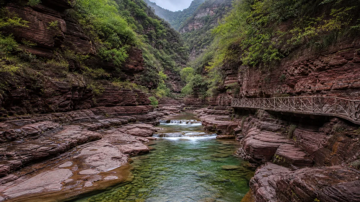
5A View location, maps and nearby scenic areasAt Hongshi Gorge, stop before the path drops between red walls and compare the dry bands above you with the wet, darkened rock beside the stream. The colour, narrowness and changing sound of water explain why this is the best-known face of Yuntai Mountain. But they do not explain the whole name printed on many 5A lists.
That official name also contains Shennong Mountain and Qingtian River. They are not valleys reached by following the next Yuntai footpath. They are separate scenic areas in different parts of Jiaozuo, with road journeys, gates and operating systems between them. Yuntai—pronounced roughly “ywin-tie”—is the most extensive first visit; Shennong is “shen-nong,” and Qingtian is close to “ching-tyen.”
Plan three places, not three zones: use a full day for Yuntai’s gorge, waterfall-valley or summit choices; choose another outing for Shennong’s ridge and macaque habitat; and treat Qingtian River as a reservoir-canyon visit whose boat component depends on current operation. A shared 5A designation is not a shared entrance.
One rating joins three road-separated landscapes
China’s 5A grade evaluates tourist areas, and one designation can group more than one named attraction. Here the combined title links Yuntai Mountain in Xiuwu County, Shennong Mountain in Qinyang and Qingtian River in Bo’ai County. That administrative relationship matters for the national list; it does not make the three contiguous.
The distinction changes a real itinerary. Yuntai has its own visitor centres, scenic-bus network and several widely separated valley and mountain stops. Shennong has a different gate and a climb organised around ridges, religious associations and wildlife habitat. Qingtian River has roads and paths focused on impounded water and canyon scenery, with boats often central to the advertised experience. Tickets, identity checks, last entry and transport products should be checked for each operator.
Online maps can compound the confusion by placing all three records at one representative coordinate or by displaying the shared English name “Yuntai Mountain.” Between actual visitor gates, a road transfer commonly needs an hour or more; the precise time varies greatly by the pair of sites, mountain-road conditions, traffic and the gate currently in use. Ask a driver to confirm the Chinese destination—云台山, 神农山 or 青天河—rather than showing only the combined rating.
The three landscapes do belong in one larger conversation. All meet the southern Taihang Mountains, where uplifted rock, faulting, erosion and rivers create abrupt relief above the North China Plain. Yet the visitor reads that relationship differently at each place: exposed sandstone in a narrow gorge, a high and sometimes airy ridge, or cliffs reflected in reservoir water.
Hongshi Gorge makes geology visible at walking speed
Hongshi Gorge is often translated as Red Stone Gorge. Its purple-red to rusty walls are commonly described as quartz sandstone. Look for horizontal bedding, near-vertical fractures and ledges that resist erosion differently. Flowing water exploits those weaknesses; rockfall, weathering and repeated incision enlarge them. The gorge feels designed like a corridor, but its underlying geometry comes from rock structure and water.
Yuntai’s landscape is discussed within the broader Yuntaishan UNESCO Global Geopark context. A geopark is not simply a trophy for one photogenic crack. It connects geological heritage with education, protection and local development across a wider territory. Its boundary and purpose should not be assumed to match the combined 5A tourist designation exactly.
On the managed path, the gorge’s scale is best understood through contrasts. A person on the walkway shows the height of the wall; a bridge reveals how little horizontal space the stream has; dry red surfaces beside dark wet ones show where spray and recent flow reach. Pools may look blue-green or jade in photographs, but colour changes with depth, mineral load, sky, light and editing. Do not promise yourself a particular palette.
The route is often operated in a directed or one-way pattern because the gorge is narrow. Temporary closures can follow storms, high water, ice, rockfall risk, maintenance or crowd controls. The handrail is a safety boundary, not an invitation to lean out for an empty frame. Sandstone that appears rough can still be slick when coated with spray, algae or fine sediment.
Build a Yuntai day around one gorge and one extension
Yuntai is not one compact loop. Hongshi Gorge, the waterfall valleys usually translated as Tanpu Gorge and Quanpu Gorge, and Zhuyu Peak occupy different branches of the visitor system. Scenic buses reduce road walking, but transfers, queues and stop changes still consume time. A useful plan chooses one non-negotiable area and one extension rather than collecting names.
For a gorge-first day, enter Hongshi Gorge early enough to move without rushing, then add a waterfall valley if its trail is open. Tanpu Gorge offers repeated small cascades, pools and water-shaped details when conditions support them. Quanpu Gorge is associated with Yuntai Sky Waterfall. Promotional descriptions often give the fall a drop of approximately 314 metres, but the number is not a water guarantee. In dry periods the stream can be slight or absent; after rain, access may be restricted precisely when flow looks dramatic.
For a height-first day, use current scenic transport toward Zhuyu Peak, whose summit elevation is commonly published at about 1,308 metres. The road ascent, final stairs and exposed viewpoints make this a different physical experience from the gorge. A bus delivers elevation, not effortless access: steep steps, wind, heat, mist and crowding remain. Visibility can vanish even when the lower valley is clear.
Trying to combine a slow gorge, both waterfall valleys and the peak creates a schedule ruled by buses and last returns. If water is the priority, check recent official notices or ask staff what is actually flowing. If the summit is the priority, confirm weather, trail status and the final downhill transport before committing to secondary stops.
A Double Ninth poem gives Zhuyu Peak meaning—but not proof
Zhuyu means the cornelian cherry or dogwood traditionally worn during the Double Ninth Festival, the ninth day of the ninth lunar month. The peak’s name invites an immediate connection with a poem learned by generations of Chinese schoolchildren.
In the eighth century, Tang poet Wang Wei wrote while away from home: “I know from afar, where my brothers climb the heights, / one man is missing where all wear zhuyu sprigs.” The poem begins, “Alone, a stranger in a foreign land, / at every festival I miss my family all the more.” The cause is absence; the turn imagines relatives performing the seasonal climb; the consequence is a family group made emotionally visible by one missing person.
The lines explain why climbing, autumn and zhuyu carry more than botanical meaning in China today. They are still recited at the Double Ninth Festival and used to express homesickness. Yet that cultural echo is not documentary proof that Wang Wei wrote about this exact Jiaozuo summit. Scenic interpretation often binds a famous poem tightly to a place whose name suits it; unless firm historical evidence is given, treat the relationship as resonance rather than biography.
That distinction improves the climb. Instead of hunting for a “poem location,” notice how a high path separates and reconnects people. Buses unload groups, stairs stretch them into a line, and a viewpoint gathers them again. The poem’s missing figure becomes understandable without turning legend into fact.
Qingtian River is a river landscape remade by impounded water
At Qingtian River, the dominant view is often still water between Taihang slopes rather than a free-running mountain torrent. Reservoir construction altered the river’s speed, depth and shoreline, creating long reflective reaches that tourism now presents by boat. Calling it simply a “natural river gallery” hides the engineering that made the present visual rhythm possible.
From a boat, cliffs appear continuous because the water removes many foreground interruptions. Watch instead for tributary mouths, changing rock colour, cut slopes, high-water marks and vegetation bands. They reveal that this is a managed water body responding to inflow and operations. Tourism names comparing reaches to better-known gorges are metaphors, not measurements of equal scale or geological identity.
The reservoir view has human consequences. Dams and water-control projects can support irrigation, supply, flood management or power, while also changing habitats, sediment movement, access and the relationship communities have with a river. Site-specific benefits and costs deserve evidence; neither a triumph-only story nor a loss-only story is sufficient. The honest observation is that today’s boat landscape is both mountain topography and engineered hydrology.
A boat may be the clearest way to understand that hybrid landscape, but it must remain optional in your plan. Water level, wind, storms, fog, maintenance, demand and safety controls can change departures, routes or boarding points. Confirm whether a ticket includes a cruise, whether the trip returns to the same pier and what the last connection requires. Do not build a tight onward journey around an undated timetable.
Shennong Mountain joins a sharp ridge, tradition and wild macaques
Shennong Mountain offers the most explicitly ridge-centred choice of the three. Paths climb through forest toward narrow or exposed sections where the Taihang relief opens on both sides. Visitor descriptions apply vivid names to rock silhouettes and pines; use them as aids to looking, not as geological categories. A “dragon ridge” is a resemblance, not a species of landform.
The mountain is named for Shennong, the Divine Farmer, a Chinese culture hero associated with teaching agriculture and testing medicinal plants. Local tradition says he gathered or tasted herbs here. Shennong belongs to mythic cultural memory rather than a historically documented traveller whose itinerary can be verified. The story matters because it expresses gratitude—and anxiety—around food, medicine and knowledge gained through risk. It does not turn every plant beside the trail into a safe remedy.
Never taste or collect wild plants. Some species are protected; others are toxic or difficult to identify. The same restraint applies to the Taihang macaques that visitors may encounter. They are wild animals, not performers included with admission. Sightings are not guaranteed, and food-conditioned macaques can grab bags or bite.
Keep food sealed and out of sight, secure loose objects, give animals an exit route and follow staff instructions. Do not offer snacks for a photograph or place a child between an adult macaque and its young. If the route is temporarily managed around animal activity, wait rather than pushing through.
Give each scenic area its own day and weather logic
With one day, choose Yuntai for the widest mix of red gorge, water-shaped valley and optional summit. With two days, add either Shennong for strenuous ridge scenery or Qingtian River for a water-led outing. Three days allow one major area per day and leave room for transfer disruption; this is the clearest way to understand why the joint designation contains three names.
From Jiaozuo city or a regional railway station, the useful question is not “How far is Yuntai Mountain 5A?” but “Which visitor centre am I reaching?” Public buses, tourist coaches and ride-hailing availability can vary by season and time of day. Return options may thin earlier than attraction closing times. Ask accommodation staff or the relevant scenic area for a current connection and save a Chinese pickup point.
Season changes the logic rather than producing one best month. Summer can bring fuller water and green slopes, but also heat, storms, slick stone and flood-related closures. Autumn can offer comfortable walking and colour, but it does not guarantee red leaves or a festival atmosphere. Winter may expose rock structure and reduce crowds, while ice, wind and suspended transport limit routes. Spring growth is attractive, though rain, pollen and temperature swings matter.
Check conditions twice: once before leaving your base and again at the gate. Confirm the open sub-areas, scenic-bus or cableway operation, boat status, last return and any timed-entry requirement. Treat journey times shown by an app as estimates, especially on mountain roads or holiday weekends.
Photograph scale without trading away safety or access
In Hongshi Gorge, place a bridge, handrail or person low in the frame to show the walls’ height; a polarising filter can reduce glare but may also erase useful reflections. Keep moving where the walkway narrows and make photographs only from legal pull-outs. After rain, protect the lens and your footing before looking for saturated colour.
At Qingtian River, a boat wake can divide reflection from cliff, but stand or change sides only when crew rules allow. A wider lens shows the engineered water corridor; a longer lens isolates bedding, vegetation and high-water marks. At Shennong, let a receding rail or ridge line explain exposure. Do not step outside a barrier to remove that same rail—it is part of the honest scene.
Accessibility differs more within each site than the shared rating suggests. Scenic buses and boats can reduce distance, yet boarding gaps, stairs, steep ramps and crowded transfers remain. Hongshi Gorge’s confined walkway can include steps and one-way movement. Summit and ridge routes require sustained stairs even when a bus or cableway removes major ascent. Water-edge surfaces can be wet, and not every vessel has step-free boarding.
Before arrival, visitors using wheelchairs or walking aids should ask about the specific open route, accessible toilets, boarding assistance and whether transport accepts mobility devices. Families should not assume a stroller works through a narrow gorge or on ridge stairs. Travellers with vertigo, heart or knee concerns should choose viewpoints by terrain rather than by the most famous photograph.
Leave the combined name in three pieces
Return at the end to the first surface you noticed. At Yuntai it may be sandstone darkened by spray. At Qingtian River it may be a cliff doubled in reservoir water. At Shennong it may be a rail tracing an exposed ridge while a macaque watches from beyond reach.
The combined 5A title is useful only after it has been taken apart. One component lets water reveal fractures in red rock; one shows how engineered water reframes a canyon; one brings myth, wildlife and physical exposure onto a mountain path. Their common Taihang setting does not erase their different histories or demands.
Wang Wei’s absent climber offers a final, quieter instruction: a landscape is also shaped by who shares it and who cannot. Leave enough time at one safe viewpoint to notice your companions, the workers managing the route and the space you are occupying. Then make the photograph with a person, boat or handrail kept in frame—not as clutter, but as the measure that turns scenery back into a human place.
Use the Yuntai Mountain 5A profile to anchor the correct record. Continue to Mount Song for a mountain landscape shaped by Buddhist and Daoist history, to the Longmen Grottoes for stone, patronage and conservation, or to the Red Flag Canal for another Taihang story where engineering and landscape cannot be separated.
Location profile
Where it is

Frequently asked questions
Are Yuntai Mountain, Shennong Mountain and Qingtian River one walkable park?
No. They are three separate scenic areas in different parts of Jiaozuo, grouped under one national 5A designation. Each has its own entrance, operating notices and internal transport. Travel between gates is a road transfer that can take an hour or more depending on the pair, route and traffic.
Which of the three should a first-time visitor choose?
Yuntai Mountain is usually the broadest first choice for a narrow red-rock gorge, waterfall valleys and an optional high peak. Choose Shennong Mountain for a steeper ridge walk and macaque habitat, or Qingtian River for a reservoir-and-canyon landscape where a boat may form part of the visit.
Can I visit all three scenic areas in one day?
It is not a sensible sightseeing plan. Gate-to-gate road transfers, separate tickets, scenic buses, boat or trail operations and large internal distances make a three-site day fragile. Give Yuntai a full day and treat Shennong and Qingtian River as separate outings unless a current local itinerary proves otherwise.
Does Yuntai's 314-metre waterfall always flow, and do Qingtian River boats always run?
No. The approximately 314-metre figure commonly attached to Yuntai Sky Waterfall describes its advertised drop, not guaranteed water volume. Rainfall, season and water management affect the view. Qingtian River boat routes can also change or stop because of water level, weather, maintenance or safety controls; confirm current notices.