Henan · Anyang and Linzhou
Red Flag Canal and Taihang Grand Canyon: Water, Rock and Labour
Read the Red Flag Canal as a 1960s water network built through scarcity, then treat Taihang Grand Canyon as a separate landscape with its own gates, routes and risks.
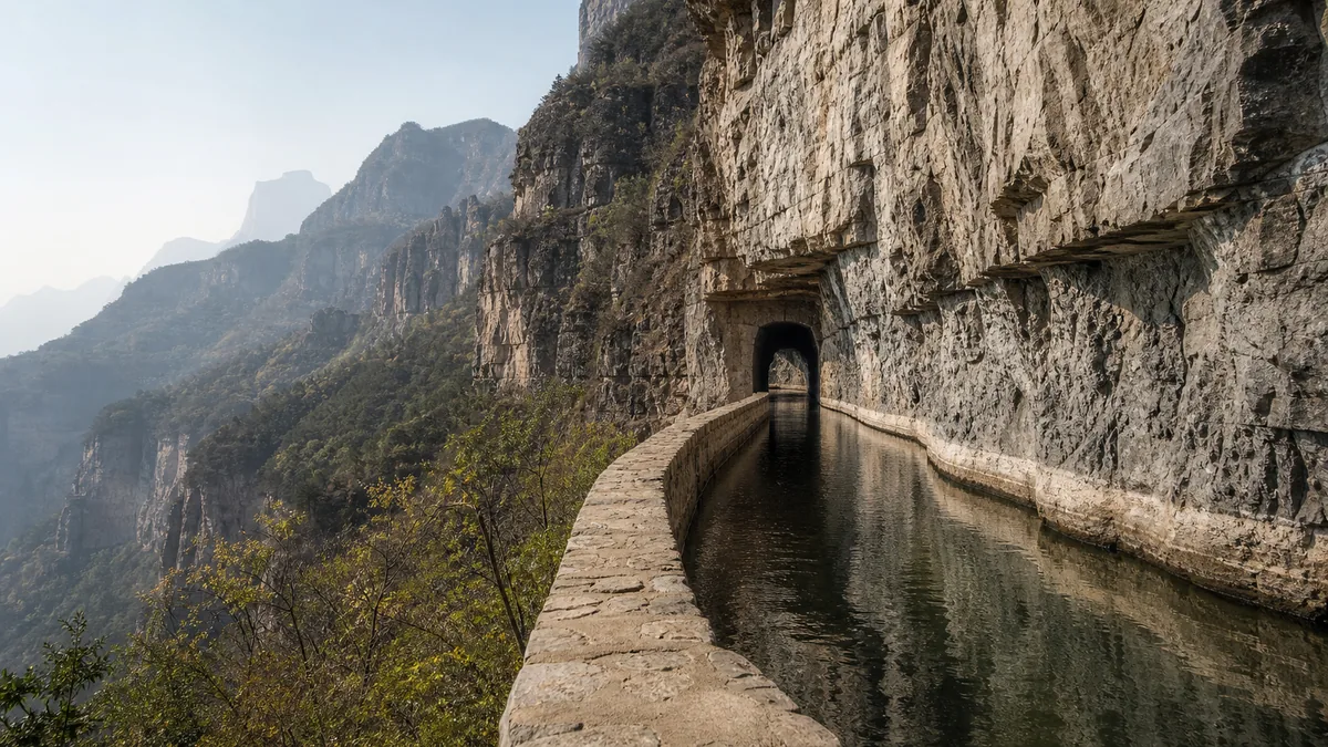
5A View location, maps and nearby scenic areasAt a cut in the Taihang cliff, place your eye level with the water channel. One edge is dressed stone and concrete; the other is mountain. The narrow line between them carried water toward villages on the dry Linzhou plain. It is easy to photograph the Red Flag Canal as a heroic stripe across rock. It is harder—and more useful—to ask who cut it, under what pressures, and where the water went next.
That question also prevents a common route mistake. Red Flag Canal and Taihang Grand Canyon share a national 5A tourism designation, but not one entrance or one continuous footpath. The first is a twentieth-century water system interpreted through engineering sites and political memory. The second is a group of natural valleys, cliffs and managed mountain routes elsewhere around Linzhou.
Plan two landscapes, not one ticket-shaped loop: use Fenshuiyuan and Youth Cave to understand how the canal divided and crossed the mountain; give the grand canyon a separate weather-dependent outing. Road time, gates and scenic transport matter more than the two names appearing together.
One 5A name covers two separate geographies
The Red Flag Canal 5A profile is a useful map anchor, not a complete route. Canal interpretation commonly centres on Fenshuiyuan, where the main channel divides, and Youth Cave, a tunnel and cliff section farther west. These are themselves separate visitor areas, linked by road rather than by a short museum corridor.
Taihang Grand Canyon lies in another mountain sector. Visitor maps commonly foreground Peach Blossom Valley, Wangxiangyan and a high scenic road, but included zones, vehicle connections and names can change. A canyon admission package does not necessarily solve transport back to a canal entrance.
For a first visit, make the canal one substantial day and the canyon another. If time permits only one, choose by question. Go to the canal to study infrastructure, collective labour and modern public memory. Choose the canyon for water-cut rock, forest, exposure and a more physically demanding route. Trying to collect both in a rushed loop often leaves the engineering unexplained and the natural landscape seen through a vehicle window.
Linzhou is pronounced approximately “lin-joh.” Older English sources may call it Lin County, or Linxian, because the county was reorganised as a city in the 1990s. The change in name can make historical accounts look as if they describe different places; they do not.
Begin with thirst, not with the slogan
Northern Linzhou sits against the eastern Taihang Mountains. Rain is uneven, thin soils lose water quickly, and many older settlements depended on wells, springs, small channels and water carried by hand. Drought was not an abstract landscape theme. It shaped crops, hygiene, household labour and whether families could remain in place.
Local efforts to store or divert water long predated the Red Flag Canal. The decisive twentieth-century proposal was far larger: lead water from the Zhang River in neighbouring Shanxi, around and through mountain barriers, then distribute it across Linzhou. Work began in February 1960. The main diversion and trunk sections were built during the first half of the decade; branches and local distribution continued toward 1969. A date such as “1960–1969” describes a network programme, not ten years spent on one tunnel.
The timing matters. Construction began during the Great Leap Forward and continued through years of severe national food shortage and political mobilisation. Local people faced both genuine water insecurity and a state system that organised labour, resources and public speech through campaigns. Any account that shows only cheerful workers misses scarcity, exhaustion and constrained choices. Any account that sees only coercion misses the technical knowledge, mutual dependence and durable value residents invested in bringing water to their communities.
At the museum or entrance displays, compare verbs. “Volunteered,” “mobilised,” “organised” and “ordered” can describe overlapping realities. The canal was made by people whose motives and freedom were not identical.
Measure a network without turning numbers into mythology
The most useful fixed figure is the main canal, commonly given as about 70.6 kilometres. Larger totals refer to more than this trunk. Official accounts frequently describe a complete network of about 1,500 kilometres; the precise 1,525.6-kilometre figure often quoted includes the main canal, major branches and many lower-level distribution channels. Later repair, boundary definitions and translation can alter what a source counts.
The same caution applies to lists of tunnels, aqueducts, peaks cut and cubic metres of earth removed. Such numbers show scale, but they are sometimes repeated without date or category. Ask whether “canal” means the cross-mountain trunk, the first three branches, or every capillary channel reaching fields.
At Fenshuiyuan, the abstract network becomes visible. The channel reaches a controlled division point and splits toward different service areas. Gates, retaining walls and flow geometry explain that the project was not simply a heroic trench: it had to allocate limited water, manage level differences and remain repairable. Water distribution also creates power. Who receives how much, at what season and under whose rules is as important as the original excavation.
Water seen today is operational, not a performance guaranteed by admission. Irrigation demand, rainfall, maintenance and safety work can lower or interrupt flow. A dry or quiet section is still legible if you follow gradient, joints, gates and sediment marks.
At Youth Cave, read hand work and engineering together
Youth Cave, or Qingnian Dong, is the canal’s best-known tunnel. Accounts commonly describe it as roughly 600 metres long, cut through hard Taihang rock by a work team associated with young labourers. Exact dimensions on signs may distinguish the tunnel bore, its visitor section or later enlargement, so use the current interpretation board rather than memorising one set of decimals.
The name turns a generation into a monument. Stand back from the carved entrance and compare the tunnel mouth with people. Drilling, blasting, spoil removal, stone dressing and lining had to proceed with limited machinery. Surveying also mattered: water moves only when the gradient is controlled. The canal is therefore not evidence that determination cancels physics; it is evidence that local builders learned to work precisely within it.
Construction had human costs. Falls, blasting, rock collapse, dust, cold and undernourishment were real hazards. Official memorial accounts record workers who died, while totals and the boundaries of what counts as a construction death are not always presented consistently. Treat names on memorials as people, not as a price tag used to prove greatness. The surviving builders also lived with injury, fatigue and years taken from farming and family care.
A period slogan declared, “Split open the Taihang Mountains and bring the Zhang River through.” It captures urgency and collective confidence, but it is not a neutral diary of every worker’s thoughts. Its modern echo is the state-promoted Red Flag Canal Spirit, usually summarised through self-reliance, arduous endeavour, solidarity and selfless contribution. Those values can honour skill and cooperation; they should not prevent questions about policy, sacrifice or who gets remembered.
Separate useful memory from a single authorised story
The canal still supplies a compelling civic story because it changed material life. Expanded irrigation and water access supported farming, settlement and later industry. Engineers, stoneworkers, village crews, cooks, medics, surveyors and families maintaining households all contributed, although heroic images often reduce the cast to men swinging hammers on a cliff.
The project also became a political classroom. Leaders including Lin County party secretary Yang Gui are central to official narratives, and training institutes continue to use the site for study tours. Red flags, sculptures and reconstructed work scenes are interpretations created after construction as well as traces of the period itself.
Visitors need not choose between worship and dismissal. Ask three questions at each display: What physical problem does this object prove? Whose voice explains it? What consequence is absent? A worn drill, a ration vessel and a distribution gate tell different histories. Photographs posed for publicity are valuable documents, but they also reveal how labour was meant to be seen.
The canal is now maintained infrastructure and heritage. Conservation can protect tunnels and aqueducts while the working network continues to serve communities. Tourism brings jobs and attention, yet it can turn hardship into scenery. Buying from local operators does not erase that tension; listening carefully is a better start.
Let Taihang Grand Canyon change the scale
In the grand canyon, the straight engineered contour gives way to water following fractures and gravity. Layers of sedimentary rock, uplift of the Taihang region, weathering and stream erosion created cliffs, narrow valleys and stepped falls over geological time. One storm did not carve the gorge, and one tourist name does not define a single geological unit.
Peach Blossom Valley is commonly the gentler water-focused choice, with paths beside pools and cascades. “Gentler” is relative: steps, damp paving and crowds remain, and waterfall volume depends on recent rain and management. Wangxiangyan offers a more vertical experience of walls, forest and climbing routes. Stairs and cliff exposure can be substantial. High scenic-road viewpoints trade walking effort for vehicle dependence, queues and changing access.
The canyon is not merely an attractive reward after a serious history lesson. Mountain villages, forestry, water management and tourism all shape the landscape. Paths, lifts, railings and glass or viewing structures are modern visitor engineering, not ancient features. Photographing them honestly can show how today’s society negotiates the same cliffs rather than pretending the view is untouched wilderness.
Heavy rain can raise streams quickly and trigger rockfall or closure; ice and wind create different risks. Never cross a barrier to reach a waterfall base, and do not assume a shuttle will keep operating after a weather warning.
Build a route around questions, weather and legs
For a canal-focused day, begin at Fenshuiyuan to understand allocation before seeing spectacle. Then transfer by road to Youth Cave and the cliff channel. This sequence turns the famous tunnel into one component of a system. Reverse it if current transport, timed entry or crowd control makes that more sensible.
A memory-focused visit adds the principal museum or memorial displays and spends less time chasing every viewpoint. Read captions for dates and categories, then return outside to match the diagrams to actual gradient and rock.
For a canyon day, choose one major valley route plus one viewpoint sector. Peach Blossom Valley commonly suits visitors prioritising water and moderate walking; Wangxiangyan suits those prepared for steeper, longer exposure. Do not assume both form an effortless circuit. Confirm open entrances, last scenic vehicles and whether a route is one-way before starting.
A full canal-and-canyon itinerary normally deserves two days based in or near Linzhou. Transfer estimates online are fragile because mountain roads, parking controls and seasonal traffic change. Keep one lower, shorter alternative for rain or tired companions. If you want to compare different Taihang water landscapes, the three separate areas of the Yuntai Mountain group need their own route logic too.
Photograph scale without stepping into danger
At the canal, the strongest image often includes three elements: channel, cliff and a person at a safe distance. A tight photograph of water alone loses the engineering problem. At Fenshuiyuan, photograph the split in flow from an authorised overlook. Near Youth Cave, use the entrance and carved alignment to show direction; never back into a drop while framing it.
Old photographs, memorial names and museum interiors may have reproduction or flash restrictions. Follow current signs. Ask before making close portraits of local residents or study groups. Drone rules can be strict around infrastructure, valleys and crowds, so treat permission as required rather than assumed.
Accessibility varies sharply. Hardened plaza and museum areas may be manageable with assistance, but slopes, thresholds and crowd barriers remain. The cliff canal, Youth Cave approaches and most canyon trails are not fully step-free. Wet stone, narrow passages and height exposure can challenge visitors with limited balance or vertigo even when a lift or shuttle removes part of the climb.
Carry water, sun and rain protection, and shoes with grip. In tunnels, let your eyes adjust and keep clear of the moving line. At cliff railings, secure loose phones and children before composing a photograph. The safest viewpoint is the one from which you can still study the landscape for more than a second.
Return to the channel and follow where it leads
Before leaving, look again along the canal rather than across it. The line disappears around a contour because its purpose was not to conquer the mountain in a single dramatic cut. It had to keep going—through a tunnel, over a ravine, into a gate and eventually toward a field or tap.
That continuing line complicates the monument. The Red Flag Canal is an engineering achievement, a product of political mobilisation, a record of dangerous labour and a living argument about collective action. Taihang Grand Canyon is a separate natural and inhabited landscape now threaded with visitor infrastructure. Neither becomes clearer when the other is treated as a bonus stop.
Put the camera down for one quiet minute at the water’s edge. Listen for flow, machinery, wind or even absence. Then make a final frame with the channel small against the cliff. It preserves both scales: a mountain that did not yield easily, and human work whose value can be respected without silencing its cost.
For other Henan landscapes where belief, labour and terrain meet differently, compare the living religious routes of Mount Song and Shaolin and the villa paths and ecology of Jigong Mountain.
Location profile
Where it is

Frequently asked questions
Are the Red Flag Canal and Taihang Grand Canyon one walkable park?
No. They are distinct areas around Linzhou grouped under one 5A designation. Canal visits commonly focus on the Fenshuiyuan junction and the cliff-cut Youth Cave sector, while the grand canyon has separate valleys, cliff trails and scenic transport. Road transfers are substantial, so confirm current entrances and normally allow two days if both matter.
How long is the Red Flag Canal?
The main canal is commonly reported at about 70.6 kilometres. Figures of roughly 1,500 or 1,525.6 kilometres refer to the much larger irrigation network, including main, branch and local distribution channels built and extended over years. Check what a sign is counting before comparing totals.
Can I see water flowing in the canal and waterfalls in the canyon?
Water is managed and seasonal, so neither a full canal nor a powerful waterfall is guaranteed. Irrigation demand, maintenance, rainfall and safety closures can change what is visible. Treat masonry, tunnel alignments and rock form as the reliable experience, and check current notices for water and route conditions.
Is the area suitable for visitors with limited mobility or fear of heights?
Some museum and junction areas have hardened paths, but gradients and steps remain. Youth Cave and many canyon routes use steep stairs, narrow cliffside sections, tunnels or wet stone; they are not fully barrier-free and can be difficult with vertigo. Ask each entrance about the shortest open route, lifts or shuttles and accessible toilets before buying tickets.