Shanxi · Linfen
Yunqiu Mountain: Ice Caves, Villages and a Ritual Calendar
Enter a cold cave, read a loess village as lived architecture, and follow how seasonal farming, local ritual and modern tourism remade a southern Shanxi mountain.
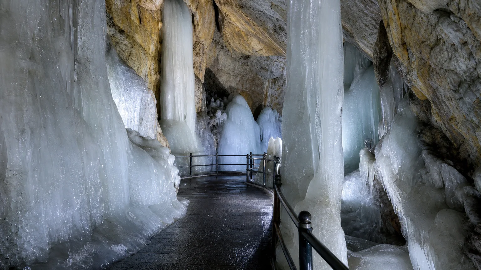
5A View location, maps and nearby scenic areasPause at the ice-cave threshold before looking at the coloured lights. Summer air can turn sharply cold, breath meets a refrigerated rock chamber, and steps descend past ice columns that seem to belong to another season. The cold is the first fact; the cave’s advertised age is a claim that requires a different kind of evidence.
That distinction opens Yunqiu Mountain. This is not one summit or one untouched ancient village. It is a broad southern Shanxi landscape where cave microclimate, loess architecture, seasonal ritual, rebuilt religious sites and a large modern tourism system now meet.
Read four layers, not one attraction list: start with the ice-cave environment, continue through Ta’erpo or Kangjiaping village, place the Zhonghe Festival and temple route in their historical setting, then look at the roads, ropeways and service labour that make today’s visit possible.
One mountain name covers several different boundaries
Yunqiu Mountain lies in Xiangning County, Linfen, where the Lüliang uplands meet the wider Fen–Wei structural basin. Official scenic-area material gives a broad Yunqiu Mountain area of about 210 square kilometres, a principal developed visitor area of about 35 square kilometres, and Yuhuang Peak at 1,629 metres above sea level. Those numbers describe different things; they should not be combined into one neatly fenced park.
For a visitor, the useful measure is separation. Villages, cave entrances, ritual buildings and summit routes occupy different slopes and valleys. A name that appears close on a simplified map may require an internal bus, a ropeway segment and more steps. Seeing every icon is less realistic than choosing one cultural line and one natural line.
The terrain alternates wooded ridges, exposed rock, ravines and cultivated pockets around settlements. Official descriptions promote very high forest cover and exceptional biodiversity, but exact percentages depend on the boundary and survey year. Onsite, look instead for visible transitions: dry sunny slopes versus sheltered gullies, managed groves versus old field margins, and water channels that determine where houses and terraces could survive.
Use the Yun Qiu Mountain 5A profile and map for regional orientation. The current scenic-area map remains essential for open entrances, one-way sections, shuttle stops and construction diversions.
The ice caves are a climate system, not a frozen clock
Yunqiu’s most famous sight is a group of chambers containing perennial or long-lasting ice. The publicly visited section opened in late 2018 after years of investigation and development. Inside, ice curtains, columns, floor ice and smaller crystals form around rock passages; constructed stairs, handrails and coloured lighting now organise how visitors see them.
Cold caves can preserve ice because shape and airflow create a thermal trap. Dense winter air enters and settles into low chambers, surrounding rock cools, and water freezes; in warmer months, limited circulation and insulation can slow melting. The balance varies with entrance geometry, fractures, snow and rain, outside temperature and human disturbance. It is more informative to watch where ice gathers—beneath a seep, along a cold pocket, at a constriction—than to treat every formation as permanent.
Scenic publicity commonly calls the cave system three million years old. That may refer to an interpretation of the surrounding geological cavity, not the age of the ice visible today. Without a cited dating method and sampled material, it should not become “this ice has been frozen for three million years.” Rock cavity, cave microclimate and individual generations of ice operate on different timescales.
Do not touch or break ice, cross barriers or use a flash where staff prohibit it. Visitors add heat and moisture, and surfaces can be fragile. Wear a warm layer with shoes that grip wet steps; sudden cold can be difficult for people with respiratory, circulatory or mobility conditions. Cave closures and timed entry are conservation and safety decisions, not a failure to deliver a promised spectacle.
Ta’erpo is architecture shaped by earth and household life
At Ta’erpo, lanes, courtyards and cave dwellings show how a community used a loess slope rather than merely building on top of it. Some rooms are cut into earth or backed by it; others use stone, brick and timber fronts. The thermal mass moderates temperature, but ventilation, drainage, smoke, light and structural maintenance remain practical problems.
The village is included in China’s recognised traditional-village system. Scenic interpretation describes it as more than two millennia old and links an earlier name, Ta’erpo, with a visit by Laozi, whose personal name was Li Er. Treat the Laozi stop as a local origin story unless a dated source is displayed; a memorable place-name explanation is not proof that the philosopher slept in a particular dwelling.
Read the village through work. Grain storage, hearths, animal space, millstones, niches and water management tell more than a row of decorated doorways. Paper cutting, dough modelling, weaving or food demonstrations may preserve skills, but schedules and participants change. Ask whether an activity is a household practice, a teaching demonstration or a performance prepared for visitors.
Ta’erpo is now a curated attraction, and Kangjiaping has been adapted substantially for cave-dwelling accommodation. Neither should be described as a community sealed outside modern life. Residents, former residents, craftspeople, designers and tourism workers all shaped what survives. An open courtyard is not permission to photograph a person at close range or enter a private room.
Zhonghe links a Tang court festival to local renewal
The Zhonghe Festival gives Yunqiu Mountain a calendar as well as a map. In 789, during the Tang, the court established Zhonghe as a festival early in the second lunar month, associated with spring, agricultural encouragement and offerings. Across much of China it later weakened or blended with neighbouring seasonal observances.
Communities around Yunqiu maintained and reshaped a local mountain gathering. People ascend, pray at temples, honour ancestors or divine powers, mark the agricultural year and meet neighbours. Yunqiu Mountain Zhonghe Festival was added to China’s national intangible cultural heritage list in 2011. That recognition concerns a living body of practice and knowledge, not just a costumed event on a stage.
The Doctrine of the Mean says, in one translation, “When harmony is realised, all things flourish.” Scenic interpretation uses this idea of zhonghe—balanced harmony—to connect people, season and land. The quotation is a philosophical frame, however, not proof that every local rite descends unchanged from one ancient text.
Public programmes may include processions, offerings, folk performance and large crowds. Their route, dates and staging are contemporary heritage practice. Observe worship without blocking an altar or procession; ask before recording a participant, divination or family offering. The festival remains alive precisely because people adapt it, not because time stopped in the Tang.
Temple peaks preserve use, loss and reconstruction together
Yunqiu’s ritual landscape includes Wulong Palace, Babao Palace, summit shrines associated with Zushi Peak and Yuhuang Peak, Buddhist spaces and village cults. Daoist, Buddhist and popular practices do not fit a simple sequence in which one replaced the other. Patronage, destruction, abandonment and rebuilding changed the mountain repeatedly.
The current operator states that after tourism development began in 2005, more than ten temples were restored or reconstructed. This is crucial context. An early foundation legend does not date every beam, mural or terrace now visible. Look for new stone cutting, concrete cores, painted timber, drainage and safety rails beside weathered fragments. Labels should distinguish the history of worship from the date of the present building.
The summit route makes hierarchy physical: gates, terraces and halls lead upward, while views connect sacred enclosure to fields and villages below. But elevation does not automatically make one tradition older or more important. A village shrine visited routinely may carry as much living meaning as a monumental summit hall.
Dress and behave as you would in an active religious place. Do not sit on altar platforms, touch images, step over offerings or direct worshippers for a photograph. Incense and fire rules can tighten during dry or windy periods. A ticket buys access under current conditions; it does not turn a temple into a film set.
Farming knowledge is richer than a single origin claim
Yunqiu interpretation often connects the mountain to Xi He observing the sky, Hou Ji teaching agriculture, and the formulation of the twenty-four solar terms. These figures and stories give local farming a prestigious civilisational genealogy. They are valuable cultural narratives, but they do not establish that the complete historical calendrical system was invented at one viewpoint on Yunqiu Mountain.
The stronger evidence is practice. Farmers tracked sun, temperature, soil moisture, frost, plant behaviour and animal cycles to decide when to sow, transplant, harvest and store. Knowledge accumulated across regions and generations before and after it was formalised in texts and calendars. A ridge can function as an observation point without being the single birthplace of a continental system.
Local huamo, decorated steamed bread, makes the calendar tangible. Different forms accompany New Year, weddings, births, funerals, ancestor rites and seasonal offerings. Shape, filling and recipient can express wishes for harvest, continuity, health or status. A demonstration is most useful when the maker explains who prepares a form, for which occasion, and whether families still use it beyond tourism.
Avoid reducing fertility imagery to something exotic. Marriage, childbirth and crop abundance were bound to household security in an uncertain agricultural environment. Women who kneaded, shaped and transmitted designs were knowledge holders, not anonymous assistants to a male religious story.
Modern tourism preserved the mountain by changing it
The scenic-area company describes investment since 2005 in temple rebuilding, village conservation, roads, reservoirs, three ropeway lines and visitor infrastructure. These works made dispersed valleys accessible, created jobs and funded maintenance. They also changed drainage, traffic, sightlines, energy use and the pace of village life.
Official material says eleven villages received some degree of protection or development, while Ta’erpo and Kangjiaping are the principal visitor examples. It also mentions construction of two resettlement communities. Those facts invite questions rather than an instant verdict: who chose to move, what happened to land and ancestral rooms, who owns tourism businesses, and how can former residents continue ritual or family access?
Heritage is not protected simply by keeping old façades. Cave dwellings need safe services; residents need schools, health care, heat and transport; fragile slopes need drainage. At the same time, replacing everyday spaces with identical shops can preserve a silhouette while losing social depth. Compare an adapted guest room, a demonstration courtyard and a quieter service lane to see different compromises.
Remember the contemporary workforce: drivers, ropeway operators, cave monitors, cleaners, cooks, craftspeople, guides, gardeners and rescue teams. Their safety decisions determine what opens. The mountain visitors experience is both inherited landscape and operating infrastructure.
Build a route around one contrast, not every ticket
For a balanced full day, pair the ice caves with Ta’erpo, then add one religious complex if transport and queues allow. This route contrasts natural microclimate with household adaptation and still leaves time to read rather than collect photographs. If the cave has timed entry, organise the rest of the day around that slot.
A high-route day can prioritise a ropeway or shuttle connection toward Zushi or Yuhuang Peak and descend through selected temples. It demands more stairs, exposed weather and coordination with the last operating transport. A culture-first day can stay lower, spending longer in village spaces, foodways and festival interpretation; it sacrifices summit views but is often richer for mixed-mobility groups.
An overnight stay can separate caves and villages from a summit route and reveal the mountain after day groups leave. Confirm which accommodation is actually operating, whether a cave-style room has stairs, ventilation or windows, and how luggage moves from the vehicle drop-off. “Traditional” describes a design relationship, not a guarantee of comfort or accessibility.
Tickets may separate the main entrance, ice caves, ropeways, shuttles and entertainment projects. Do not assume a bundle includes every segment or that a map line guarantees operation. Carry your passport, confirm current identity requirements, ask for the last return service, and keep a lower-level alternative for wind, lightning, ice, maintenance or crowd controls.
Photograph temperature, labour and scale with care
In the ice cave, a figure on the marked walkway can show scale better than isolated coloured ice. Protect highlights, brace without leaning on formations, and obey rules on tripods, flash and commercial equipment. Condensation can fog a cold lens when you return outdoors; seal the camera or phone before the temperature change and let it warm gradually.
In Ta’erpo, photograph the relationship between cut-earth rooms, masonry fronts, courtyards and slope. Include drains, chimneys and storage rather than treating every doorway as ornament. Ask before photographing residents, artisans, domestic interiors or ritual food. A workshop ticket is not blanket consent for a portrait.
The village and some lower plazas may offer comparatively gentle sections, but stone lanes, thresholds and slopes interrupt step-free travel. Caves contain cold, wet steps and confined passages; summit temples add long stairways and exposed ridges. Ropeways and shuttles reduce distance but may not remove steps at boarding points. Ask for an accessibility route based on today’s equipment, not a generic online claim.
Wear stable shoes, carry water and use sun protection outside even when the cave is cold. In rain, avoid ravines and slick stone; in winter, expect ice; in summer, watch for heat and thunderstorms. Drones, glass structures and adventure activities have separate restrictions. Choose them only after checking weather, medical limits, weight or age rules and current certification onsite.
Let the mountain remain more than one origin story
Return mentally to the ice-cave threshold. You now know that the cold is real, while the age of the cavity, the age of today’s ice and the age of its tourism display are three different questions. The same discipline improves the rest of Yunqiu: an ancient festival can have modern choreography, an old village can contain new livelihoods, and a rebuilt temple can serve a continuing need.
Continue through southern Shanxi with the migration memory of the Hongdong Great Locust Tree, compare another ritual mountain at Mian Mountain, or set Yunqiu’s managed caves beside the canyon infrastructure of Baquan Gorge. Each landscape asks how access changes the thing it reveals.
Yunqiu Mountain does not need to be the single birthplace of the calendar, an untouched folk enclave or a frozen geological clock to matter. Its deeper value lies in relationships: cold air and rock, field and season, household and slope, worship and rebuilding. Watch those relationships and the mountain becomes harder to summarise—but much easier to remember truthfully.
Use the LoreLens app to distinguish Yunqiu’s cave microclimate, village construction, ritual buildings and modern visitor infrastructure while you explore.
Location profile
Where it is

Frequently asked questions
Are Yunqiu Mountain's ice caves open all year?
Do not assume so. Cave access can change with ice conditions, maintenance, crowd control and weather, while internal transport may have separate operating periods. Check the scenic area's current notice before travelling and carry a warm layer even in summer.
How much time should I allow for Yunqiu Mountain?
A full day can combine the ice-cave area, one historic village and selected ritual buildings if internal transport connects them efficiently. Add an overnight stay or a second day for summit walking, slower village interpretation or seasonal events; queues and transfers can reduce what fits.
Can I visit without climbing many steps?
Shuttles and ropeways can reduce some elevation gain, but caves, village lanes, temples and summit approaches still include steps, slopes, thresholds and uneven surfaces. Ask the visitor centre for the current least-stepped route and confirm which lifts, vehicles and accessible toilets are operating.
When is the Zhonghe Festival at Yunqiu Mountain?
The local observance is associated with the second lunar month, especially its opening and midpoint, but the public programme, ritual access and crowd controls vary by year. Confirm the official annual schedule rather than converting a lunar date once and reusing it.