Shanxi · Changzhi
Baquan Gorge: Water, Walls and a Vertical Journey
Follow clear water beneath layered Taihang cliffs, read springs and potholes as evidence rather than legend, and choose how much boating, height and steep walking belong in your day.
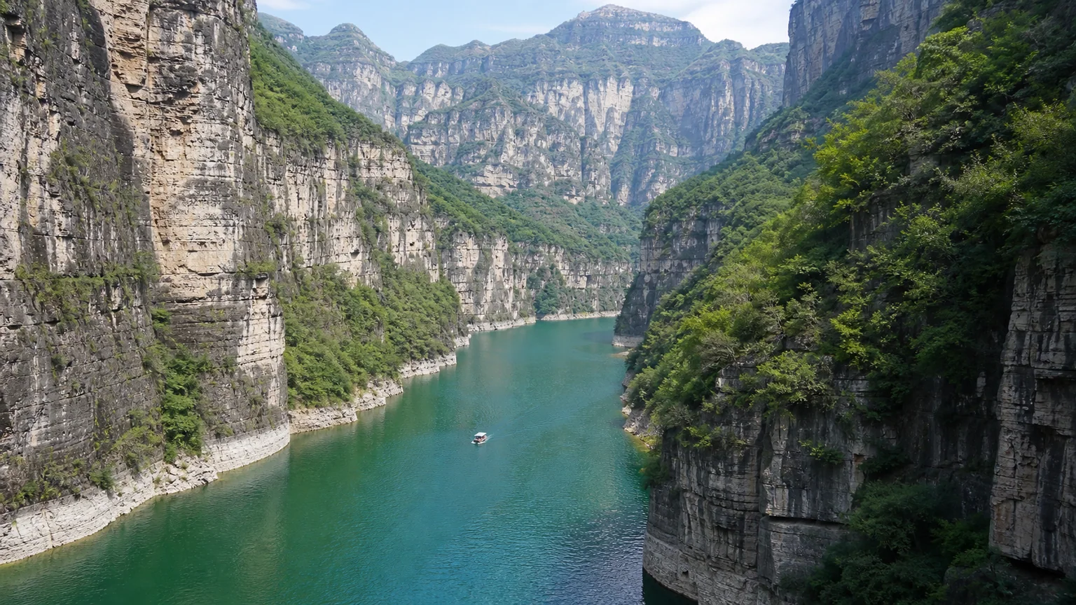
5A View location, maps and nearby scenic areasBegin at water level, not at the highest viewing platform. The first useful view in Baquan Gorge is a narrow band of green-blue water held between tall, layered walls. Reflections simplify the cliff into stripes; fallen blocks and vegetation interrupt the geometry. If a boat passes, its wake briefly redraws the rock.
This is an observable gorge, not proof of every superlative attached to it. Tourism materials call Baquan Gorge the “foremost grand gorge of the Taihang” and describe world-class scenery. What you can test yourself is more interesting: water occupies a steep rock corridor; bedding, fractures, alcoves and debris show that the walls are not uniform; springs emerge at particular levels; and an engineered chain of paths and transport turns a difficult mountain cross-section into a visitor route.
Choose by exposure and time, not by attraction count: a lower-gorge visit concentrates on water, springs and shorter waterside walks; a full vertical circuit, when all links operate, may combine shuttle, boat, gorge walking, cableway, ridge paths and sightseeing elevator. The Taihang Mountains 5A scenic-area profile is the site anchor. Use the current official map for the actual direction, boarding points, separate charges and closed sections.
The gorge is a cross-section, not one panorama
Baquan Gorge lies in Huguan County within the Taihang Grand Canyon landscape east of Changzhi. The managed attraction spreads from a reservoir and lower entrance corridor into a narrower stream-cut interior, then climbs toward high ridges and constructed viewpoints. Its scenic-area name was formerly associated with “Eight Waters”; the present name refers to groups of springs remembered as emerging in eights. Treat that as place-name tradition, not a requirement that exactly eight visible jets appear on your day.
At the bottom, the walls restrict the sky and make distance hard to judge. Higher up, the same gorge becomes a line cut into a broader mountain surface. Seeing both levels matters. A water-level photograph shows enclosure, while a ridge view reveals tributary gullies, resistant ledges and the scale of visitor engineering.
The route is therefore not a simple riverside stroll. A location that appears close across the map may sit hundreds of vertical metres away or beyond a transport transfer. Boats, internal vehicles, cableways and elevators have been used to join otherwise disconnected levels. Their presence explains the standard circuit; it also makes the visit vulnerable to wind, lightning, water level, inspection, maintenance and crowd controls.
Rock uplift created relief; water exploited weakness
The Taihang Mountains form a major topographic boundary between the Shanxi uplands and the North China Plain. Geological research supports a long history of tectonic deformation, uplift and denudation, with important phases during the Cenozoic. That regional history helped create relief, but it does not justify a neat claim that Baquan Gorge itself was “made” in one dated event.
Once relief and drainage existed, running water could cut downward and carry loosened material away. It worked selectively. Water entered joints and bedding planes; weathering weakened exposed faces; freeze-thaw, roots and gravity helped detach blocks; floods moved sediment and abraded the channel. The result is a steep corridor shaped by repeated interaction among rock structure, runoff and slope failure—not a canyon sliced by water alone like a knife through solid material.
Look for horizontal or gently inclined layers, vertical fractures, recessed bands and angular blocks below the walls. A ledge may mark a more resistant bed; an alcove may reflect a weaker layer or concentrated seepage. These are field observations. Scenic names that see animals, gates or deities in the same shapes are cultural interpretation. Both can enrich the walk if one is not presented as proof of the other.
Springs explain the name better than a number
The clearest local geological explanation appears at springs such as Xiao Baquan, or Little Eight Springs. Scenic interpretation describes groundwater descending through relatively permeable carbonate rock until movement is impeded by a less permeable shale layer. Water then travels along that boundary and issues from the valley wall. The useful idea is the contact between beds, not a promise about a fixed discharge.
That mechanism also explains why springs can line up at similar heights. Rain and snowmelt enter fractures and pores upslope, move underground, and reappear where geology and topography intersect. Flow may lag behind a storm, persist through a dry spell, or weaken after drought. Mineral-rich water can leave pale deposits or support moss, but colour alone does not prove purity or potability.
The official place story connects the name to groups of eight spring outlets. Count if the outlets are distinct, but do not force a changing water system into folklore’s arithmetic. Seepage can split, merge or vanish behind vegetation. Never drink untreated water merely because a label calls it “sacred” or “natural,” and do not step across a barrier to reach a source.
Potholes and pools record energetic flow
Along the stream course, rounded hollows in the bedrock are sometimes labelled potholes. These are not caves punched instantly by a single flood. Turbulent water can trap pebbles in an eddy; repeated impact and abrasion enlarge a depression. Once a hollow forms, its shape can help maintain the rotating flow that continues the work.
Find the contrast between those rounded forms and freshly broken angular debris. The first points to sustained abrasion; the second may record rockfall, frost action or recent breakage. Pools, steps and cascades likewise reflect variations in rock resistance, jointing, sediment and flow. Avoid promotional phrases such as “billions of years of washing” as a measurement. The rock may be ancient, while the present landform is younger and still changing.
Water colour is equally conditional. Depth, shade, suspended sediment, algae, the pale bed and reflected vegetation can all shift a pool from blue to green or brown. After rain, clarity may fall even as waterfalls strengthen. In cold periods, ice can conceal moving water and turn boardwalks or stone paving into hazards. The photograph and the hydrology are snapshots, not permanent properties.
The visitor circuit is a modern mountain system
Baquan Gorge’s experience depends on infrastructure: entrance roads, a dam and reservoir corridor, docks, boats, cliff stairs, a cableway that changes alignment, ridge walks, a high sightseeing elevator, shuttles, barriers and monitoring. Some elements are marketed as attractions in themselves. More importantly, they are a transport system across substantial horizontal and vertical separation.
That system represents labour. Earlier residents crossed slopes on local paths and used mountain water, woodland and small areas of workable land. Path builders and construction crews drilled anchors, carried steel, poured foundations and installed drainage in exposed positions. Today boat crews watch water and boarding conditions; cableway and elevator teams inspect machinery; shuttle drivers manage narrow roads; cleaners, rangers, ticket staff and rescue teams keep the route functioning.
Infrastructure improves access but also concentrates pressure. Reservoir management changes the visual and aquatic environment. Paths fragment vegetation and direct runoff. Boats add wake and noise; summit facilities require power, water and waste removal. Large queues can push people toward shortcuts and fragile edges. Staying within the managed corridor is not only obedience—it helps keep trampling, litter and emergency risk from spreading.
Short and long routes make different compromises
For a shorter, lower-gorge visit, prioritise the reservoir approach, any operating boat segment and the authorised waterside walk toward visible springs or cascades. This holds attention at the most legible relationship among water, rock and shade. It may suit visitors who dislike exposed heights, but it is not automatically step-free. Confirm whether an out-and-back return is allowed; one-way crowd controls can make an expected shortcut impossible.
For the full circuit, allow most of a day. If operating, the usual concept links water transport and gorge walking with a major ascent or descent by cableway and/or sightseeing elevator, plus ridge paths and internal vehicle transfers. The reward is comparison: enclosure below, wide relief above, then a mechanical transition through the cliff. The cost is more queues, more exposure, more transfers and less freedom to reverse direction.
A walking-heavy alternative may replace a mechanical link only where an authorised trail is open. Official descriptions include long cliff walks and thousands of steps; these should not be treated as casual substitutes. Ask about total ascent, descent, surface, escape points and last entry. Never improvise along a closed stair because a cableway has stopped. Staff may reroute or curtail the circuit for safety.
Ticket bundles, identity checks, facility fees, reservations, opening hours and the direction of travel can change. Carry the document used for any booking if current rules require it. Photograph the day’s map, note the last boarding times, and ask which missed connection would strand you furthest from the exit.
Height and access need honest planning
The sightseeing elevator removes one large vertical segment when it runs; it does not remove the approach, queue, boarding threshold, upper paths or emergency stairs. The cableway similarly saves effort but introduces height, enclosed cabins and possible suspension in wind or storms. Visitors with vertigo may find a glass-sided facility harder than a mountain stair, while visitors with knee problems may make the opposite choice.
Wheelchair users and travellers who cannot manage stairs should contact the scenic area before arrival and confirm again onsite. Ask specific questions: Is boarding level? Are wheelchairs accepted on the boat or cableway? Is there a lift at every transfer? Can a companion assist? Where is the accessible return if weather closes the next link? “Accessible service at the visitor centre” does not certify an entire mountain circuit.
Families should count waiting as part of fatigue. Keep children between adults on cliff walks and away from the boat edge. Travellers with heart, respiratory or balance concerns should avoid turning the full circuit into a test. A shorter view completed comfortably is a better reading of the landscape than a summit reached while depleted.
Weather and water can rewrite the day
In a narrow gorge, upstream weather matters even when the entrance is dry. Intense rain can produce rapid runoff, falling debris and rising water; it can also prompt boat, trail or entire-area closure. After storms, rockfall risk and damaged surfaces may remain after the sky clears. Do not shelter directly beneath an overhang or stop in a drainage channel unless staff direct you there.
Rain, spray, algae and polished paving make the lower route slippery. On high sections, wind, lightning, fog and sudden temperature change become more important. Wear shoes with reliable grip, carry a light waterproof layer, and keep both hands available on stairs. In cold weather, confirm ice controls and seasonal closure rather than assuming a cable or elevator makes winter conditions irrelevant.
Follow barriers around loose slopes and water. Do not enter pools, jump between rocks, feed wildlife or throw objects from high viewpoints. Drones, tripods and commercial shoots may be restricted, especially near transport systems and crowded platforms. Emergency response takes longer inside a gorge, so save the official rescue contact and tell a companion if you separate.
Photograph relationships, not risky poses
At water level, place a boat, railing or consenting person low in the frame to give the walls scale. Hold the camera level so the rock layers remain readable. A polarising filter may reduce glare, but over-processing turquoise water erases the evidence of changing light, depth and sediment. In deep shade, brace against your body rather than balancing on a wet rail.
For geology, pair one wide frame with a detail: first show a spring’s position on the wall, then the contact or seepage close-up from the path. Photograph a pothole obliquely so its depth and relation to flowing water are visible. Do not insert a hand, coin or person into a restricted channel for scale.
From above, include the gorge line and surrounding surface instead of filling the image with a glass platform. Stop walking before raising a phone, and never step backward for composition. Let the built system enter some frames: docks, cables, anchors and elevator shafts reveal how today’s “natural” visit is assembled.
End again near the water. The cliff is still imposing, but it is no longer a single wall. It is layered rock opened by fractures, weather, runoff and gravity; a water system that appears and disappears; a working landscape maintained by residents and staff; and a managed circuit whose machines can stop. Baquan Gorge becomes more convincing when its promotional titles are set aside. Water, stone and labour already provide enough drama.
Compare this vertical corridor with the ritual landscape of Yunqiu Mountain, the cliff-built religious zones of Mian Mountain, or the social architecture of Huangcheng Chancellor’s Mansion.
The LoreLens app can help you distinguish Baquan Gorge’s rock layers, spring outlets, stream erosion and modern visitor infrastructure as you move between water and ridge.
Location profile
Where it is

Frequently asked questions
How long should I allow for Baquan Gorge?
Allow most of a day for the full visitor circuit, because boat, cableway, elevator and shuttle queues can be as important as walking time. A lower-gorge visit may be shorter if current rules permit an out-and-back route. Confirm the day’s open sections, imposed direction and last transport before entering.
Must I take the boat, cableway and sightseeing elevator?
Not necessarily, but the answer changes with the route system in operation. Some circuits use one or more of these facilities to bridge water, height and distance, while alternatives may involve far more stairs or may be closed. Ask staff what can actually be omitted and how that changes the return.
Is Baquan Gorge suitable for visitors with limited mobility?
The visitor centre and some transport-linked segments may be manageable, but boarding gaps, queues, slopes, stairs, cliff paths and transfers remain. A lift is not the same as a step-free route. Request the current least-stepped itinerary and confirm accessible toilets, boarding help and an evacuation plan before buying a combined ticket.
When is the water at its best?
There is no guaranteed date. Spring flow, reservoir appearance, cascades and path conditions respond to recent rain, drought, water management and freezing. Heavy rain can improve flow but also trigger closure, slippery surfaces, rapid runoff and rockfall risk. Check same-day notices rather than planning from a promotional photograph.