Shandong · Linyi / Weifang
Yimeng Mountain: Choose a Range, Not One Trail
Choose Yishan, Yunmeng or Guimeng before you travel, then read separate ridges, forests, geology and wartime memory without mistaking a cross-city scenic umbrella for one mountain gate.
5A View location, maps and nearby scenic areasWhen a sign says Yimeng Mountain, do not follow the first arrow uphill. Find the smaller place name beneath it. Does it say Yishan, Yunmeng or Guimeng? That second name determines not just the trail but the county, arrival hub, ticket and often the entire day.
“Yimeng” joins the ranges of Yi and Meng into a regional idea. The 5A-rated Yimeng Mountain Tourism Area uses that idea as an umbrella across separated scenic zones in Weifang and Linyi. It is useful for recognition but dangerous for itinerary planning: there is no single Yimeng gate from which three trails branch.
Choose the zone before choosing the hotel. Yishan lies in Linqu County under Weifang; Yunmeng lies in Mengyin County under Linyi; Guimeng lies in Pingyi County under Linyi. Each can fill a day. Moving between them means returning to roads and county transport, not continuing over one connected ridge.
The 5A name is a network, not a single mountain park
Chinese scenic-area grades can apply to a combined tourism unit, and Yimeng Mountain is a clear example. The commonly presented core choices—Yishan, Yunmeng and Guimeng—are geographically separated and managed through their own entrances and internal transport. A ticket, shuttle or cable-car arrangement at one should not be assumed valid at another.
Maps can make the confusion worse. A regional map compresses mountain roads, while an attraction diagram often begins only after the gate. Two zones that appear adjacent in a brochure may require a long road transfer, sometimes across municipal or county boundaries. Online guides may also mix in Tianmeng or other Yimeng-branded sites; verify whether the place is included in your current ticket and transport plan rather than relying on the shared mountain name.
Treat one major zone as one mountain day. Trying to collect all three in a day replaces ridges with car windows and makes weather disruption harder to absorb. A multi-zone trip is possible, but it is a road itinerary with separate hikes, not a traverse.
Choose Yishan for eastern ridges and the Dongzhen tradition
Yishan is the eastern and northern option, in Linqu County, Weifang. Its peaks rise above a landscape of forest, exposed rock, ravines and distant plains. On a clear day, the value is not a single object but the changing relationship between enclosed valleys and open ridges.
Yishan also carries a long ritual identity. It was counted among China’s historical Five Great Town Mountains, with Yishan associated with the eastern “town mountain.” The Dongzhen Temple tradition at its foot records how states and local communities addressed mountains through sacrifice, inscription and repair. Present buildings and displays include layers of restoration, so do not label every roof or stele as untouched ancient fabric; look for dates and conservation notes.
This is the practical choice for travellers approaching from Weifang or the northern Shandong circuit. It is not a quick side entrance to the two Mengshan zones. Forest roads, scenic vehicles and mountain paths change with season and management, and distant views depend on haze, cloud and wind.
Choose Yunmeng for forest, valley sound and variable water
Yunmeng, in Mengyin County, is often the most intuitive choice for a forest day. Trails move between shaded slopes, streams, rock channels and higher viewpoints. Listen for water before searching for a named waterfall: the sound tells you more about recent rain than a promotional photograph does.
Water is not a scheduled attraction. A wet period can animate cascades and deepen the forest atmosphere; after dry weather, the same channel may expose stone and carry only a thin flow. Heavy rain can also close paths or make streamside paving dangerous. Check recent conditions rather than assuming either a full waterfall or a dry, easy trail.
Yunmeng suits visitors who prefer a layered valley-to-ridge experience and shade for part of the day. It still involves gradients and stairs, even when internal transport or a cableway is available. Tree cover can soften sun but also hide approaching cloud and keep stone wet.
Choose Guimeng for height and a longer ridge rhythm
Guimeng, in Pingyi County, reaches the highest part of the Mengshan massif, with the main summit a little above 1,150 metres. That figure describes elevation above sea level, not the amount you will climb: your actual ascent depends on the gate, vehicle and cableway operating on the day.
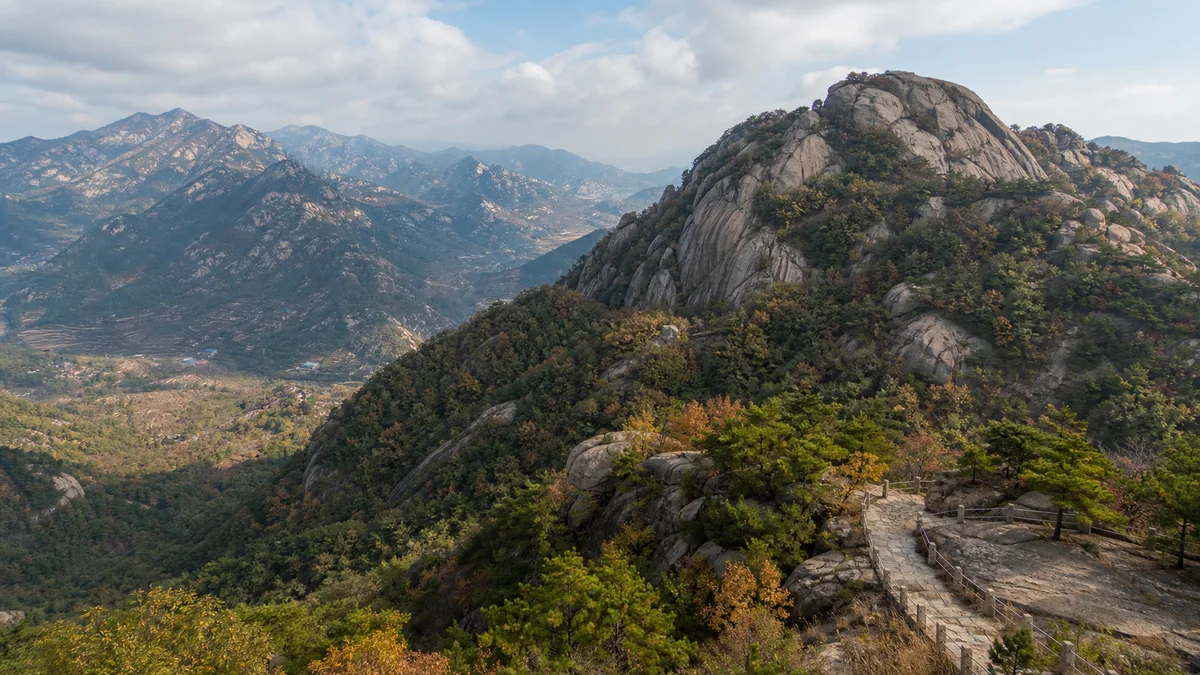
The reward is a sustained sense of height. Ridge paths move between broad views, wooded sections, exposed stone and built viewpoints. On clear days, successive folds of low mountains show how wide the Yimeng region is; in cloud, the experience contracts to pines, wet rock and the next flight of steps.
Guimeng is the stronger choice for a summit-oriented day, but do not confuse scenic infrastructure with an effortless peak. Cableway queues, steep connectors and descent time all matter. Large cliff imagery, platforms or other modern visitor structures are contemporary additions to the mountain, not geological or ancient evidence.
Read the rock without stretching the UNESCO label
The Yimengshan UNESCO Global Geopark was designated in 2019. Its mapped territory lies in Linyi and brings together multiple geological areas and communities; it is not simply the boundary of one Guimeng ticket, and it is not identical to the cross-city 5A tourism area. In particular, Yishan’s place in the 5A umbrella does not automatically put it inside the UNESCO geopark.
The broader geopark tells a long story through ancient crystalline basement rocks, later intrusions and sediments, faulting, uplift, erosion and weathering. Different districts preserve different evidence. The flat-topped Daigu landform, for example, is an important part of the wider geopark story, but it is not a feature you should claim to have seen merely because you walked a granite ridge in a Mengshan scenic zone.
UNESCO Global Geopark status recognises a territory that connects geological heritage with education, conservation and local life. It is not a prize for the highest peak, a certificate for every tourist structure, or permission to remove rock. Use official geopark maps and interpretation boards to identify a geosite; shared branding alone is not proof.
These forests are lived in, worked and repeatedly repaired
From a high path, terraces, reservoirs, villages and roads can look like small decorations beneath an apparently wild mountain. They are evidence that Yimeng has long been inhabited. Farming, fuel gathering, forestry, temple service, road building and now tourism have all shaped the slopes and household economies.
Much of the green landscape visitors value has a management history. Protection, planting and fire prevention can coexist with older woodland and natural regeneration. Calling every forest “primeval” erases labour and makes conservation seem automatic. Watch for differences between planted stands, mixed woodland, cultivated edges and exposed rock rather than treating all green as one timeless surface.
Visitors enter that working landscape. Keep clear of service roads and water collection, do not pick crops or plants, and do not photograph villagers at close range without permission. Mountain villages are communities, not costume backdrops for a scenic-area story.
Wartime memory begins with ordinary people, not a slogan
During the War of Resistance against Japan and the subsequent Chinese Civil War, the wider Yimeng region became an important base area and a landscape of military movement, supply and fighting. Memorial culture later condensed this history into the idea of the Yimeng spirit, emphasising the close relationship between Communist forces and local people.
To understand that phrase, restore the verbs hidden inside it. Rural households supplied grain, made shoes, carried stretchers, nursed wounded people, carried messages, hid personnel and saw relatives leave for the front. They also endured occupation, requisition, disrupted harvests, displacement, injury and death. Women are often represented through the collective image of the “Yimeng Hongsao,” but they were individuals with different families, risks and choices—not one interchangeable heroic character.
Not every trail is a battlefield, and not every memorial belongs inside the three 5A mountain gates. Read the site label for the event, date and people being commemorated. At graves and memorial rooms, lower your voice, avoid celebratory poses and do not turn civilian loss into a dramatic photo prop. The landscape becomes more meaningful when support, coercion, grief and survival remain visible beside courage.
Cableways, glass structures and mountain weather are conditional
Internal buses and cableways can make a high route possible for more visitors, but their operation depends on wind, thunderstorms, ice, maintenance and crowd control. Glass bridges, decks or cliff facilities may have separate access rules and can close even when the broader park remains open. Confirm current notices at the specific zone, not at a generic “Yimeng Mountain” page.
Mountain conditions can change within one ascent. Carry water, sun protection and a rain layer; use shoes with grip; turn back from exposed ridges when staff close them. After rain, painted paving, timber, glass and stone steps can all be slick. In winter, shaded ice may persist after roads below have cleared.
Accessibility is route-specific. A vehicle may reach a plaza or cableway station without making the summit circuit step-free. Transfers, thresholds, steep ramps and uneven ridges remain. Ask the individual scenic area which viewpoints are currently reachable without stairs, and plan a satisfying lower route rather than treating an inaccessible summit as a failed visit.
Build the journey around one mountain day at a time
For one day, pick by arrival geography and desired terrain. From the Weifang side, Yishan makes a coherent eastern mountain and ritual-history day. From Mengyin, Yunmeng offers forest and water when conditions support it. From Pingyi, Guimeng gives the strongest summit and ridge emphasis. Confirm the correct gate in Chinese before setting out; identical “Yimeng” labels are not enough for a driver.
For two or three zones, place a road-transfer day or separate overnight bases between them. Public transport may require county hubs and schedules can change; a private vehicle saves transfers but does not shorten the mountains themselves. Do not pre-purchase tightly timed cableway or onward tickets without allowing for weather.
Photograph the distinctions that make your chosen zone legible: a dated ritual inscription against Yishan’s ridge, water moving over stone in Yunmeng, or receding folds of terrain from Guimeng. Keep drones to officially permitted areas and never climb barriers for an empty foreground. At the final viewpoint, look for the road leaving the mountain. It is not an interruption to the Yimeng story. It is the line that explains why the next named mountain is another journey.
The LoreLens app helps you separate Yishan, Yunmeng and Guimeng while reading Yimeng’s geology, working landscapes and wartime memory in their correct places.
Location profile
Where it is

Frequently asked questions
Is Yimeng Mountain one scenic area with a single entrance?
No. The 5A Yimeng Mountain Tourism Area is an umbrella designation spanning separated mountain zones, commonly Yishan in Weifang and Yunmeng and Guimeng in different Linyi counties. They do not share one gate or form a continuous walking route.
Should I choose Yishan, Yunmeng or Guimeng?
Choose Yishan for an eastern mountain landscape and the historic Dongzhen ritual tradition, Yunmeng for forested valleys and rainfall-dependent water, or Guimeng for a higher, more sustained ridge day. Your arrival city and tolerance for steps matter as much as the list of sights.
Is the entire 5A attraction inside Yimengshan UNESCO Global Geopark?
Do not treat the boundaries as identical. The UNESCO Global Geopark, designated in 2019, is a broad but specifically mapped territory in Linyi; the 5A tourism umbrella also includes Yishan in Weifang. Check the geopark map before attaching UNESCO status to a particular site.
Do cable cars and sightseeing vehicles remove the need to climb?
They can reduce elevation gain when operating, but steps, steep approaches, transfers and uneven ridge paths remain. Cable cars, glass facilities and shuttles can close for wind, lightning, ice, maintenance or crowd control, so confirm current operation and accessible limits.