Hebei · Baoding
Yesanpo: Read the Canyons, Water and Recovery
Choose one open Yesanpo area at a time, then read canyon walls, the Juma River and cave landscapes alongside village livelihoods and recovery from the destructive 2023 floods.
5A View location, maps and nearby scenic areasAt Yesanpo, do not begin by following the first sign labelled “scenic area.” Stop with a current map and locate the separate valleys, river sections, cave entrances and roads. Bailixia, the Juma River and Yugu Cave are not features along one continuous park trail. They are dispersed nodes in a mountain region.
That distinction became especially important after the extreme rainfall and floods of 2023, which damaged communities, transport and visitor infrastructure in Laishui County. A beautiful canyon is also a channel for powerful water. Visit only what current authorities say is open and safe.
Build the day around one confirmed zone: Bailixia for canyon walking, a permitted Juma River section for water and settlements, or Yugu Cave for underground geology. Add a second zone only after checking roads, tickets and transfer time. Cableways, rafting, cave routes, shuttles and glass facilities can never be assumed operational.
A mountain region, not one gated park
Yesanpo lies in Laishui County, where the Taihang and Yanshan mountain systems meet. Official area figures vary because “Yesanpo” may describe a broad destination, a 5A boundary, several managed scenic zones or a wider geological landscape. Quoting one number without its boundary creates false precision.
Bailixia offers tight canyon walking. Juma River areas follow water and villages. Yugu Cave introduces underground passages and springs. Other nodes may appear on maps, but management differs. Travel between zones uses public roads, not an internal footpath.
The Yesanpo 5A profile gives regional orientation. For a real visit, use a dated official map. An old ticket package, shuttle diagram or blog itinerary may describe infrastructure that has since changed, particularly after flood repair.
The UNESCO geopark is larger than Yesanpo
Yesanpo is associated with the Fangshan UNESCO Global Geopark, a cross-boundary geological territory extending through sites in Beijing and Hebei. The UNESCO designation belongs to that larger geopark, not solely to one gorge, cave, ticketed entrance or the 5A destination.
Regional importance comes from varied rocks, structural movement and erosion. Where mountain systems meet, faults and folds organised weaknesses that streams exploited. Different sectors have different rock units, so do not call the whole park one limestone, sandstone or granite canyon.
Some caves developed where groundwater dissolved suitable carbonate rock. Some steep canyon forms reflect resistant layers, fractures, uplift and river incision in combination. Geology works through interacting processes. Read the rock type and age from local panels at each node instead of applying one explanation everywhere.
Bailixia makes running water visible in stone
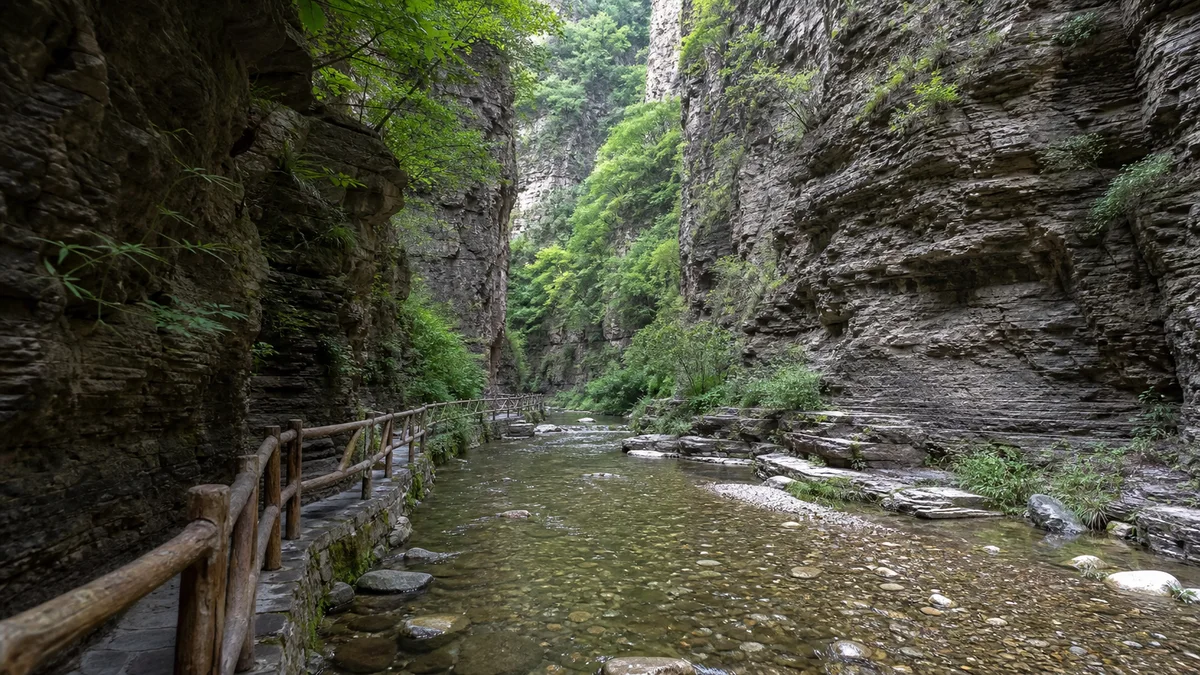
In Bailixia, the most useful action is to look across the canyon rather than only upward. Compare smooth channels and rounded debris near water with angular fractures higher on the walls. The first records transport and abrasion; the second may reveal joints, bedding or rockfall surfaces. Vegetation marks ledges that hold soil and moisture.
The canyon network has several branches that promotion compresses into one name and distance. One-way controls, repairs and closed side valleys may change the route. Follow signs rather than assuming a full loop.
Narrow walls create shade and cool air, but also limit escape and communication. Do not treat a dry channel as a safe resting place. Rain upstream can raise water even when the sky immediately overhead appears brighter. If staff close a gate or direct an evacuation, the geology is explaining why.
Juma River and Yugu Cave require different ways of looking
Along an open section of the Juma River, observe how settlements, roads and cultivated pockets use the limited flatter ground beside water. The river supports scenery and recreation but also carries sediment and flood energy. Rafting or boat activity, where advertised, depends on water level, weather, inspection and operating permission; it is not guaranteed transport or a safe substitute for a closed trail.
At Yugu Cave, if open, the timescale and light change. Dissolving water can enlarge fractures in carbonate rock and deposit mineral forms, but each feature needs its own explanation. Stay on the installed route, do not touch formations, and expect damp floors, steps, low light and a cooler interior. Flash or tripods may be prohibited.
The river and cave should not be squeezed into the same hurried narrative. One reveals a living surface drainage system; the other records groundwater moving through rock. Their separate locations are part of the lesson.
The 2023 flood is a human history, not scenery
In late July and early August 2023, extreme rainfall across northern China caused severe flooding and slope failures in Laishui and the wider region. Roads, bridges, rail links, homes, businesses and scenic infrastructure were damaged. Residents, workers and visitors faced disruption and loss.
Recovery exceeds replacing a boardwalk. Engineers reassess channels, slopes, bridges and evacuation routes; families rebuild homes and incomes. Zones can reopen at different times, then close for weather or construction. “Yesanpo has reopened” is not enough for a specific itinerary.
Do not seek damaged houses or reconstruction sites as dramatic backdrops. Ask before photographing residents and avoid questions that turn loss into entertainment. Spending with operating local accommodation, food businesses and guides can support livelihoods, but only where travel is officially welcomed and does not obstruct work.
Villages make the landscape usable and inhabited
Yesanpo is not empty wilderness between ticket gates. Villages, farmland, guesthouses, restaurants, drivers, maintenance crews and rescue services make tourism possible. Local knowledge about water and roads is practical expertise, though it does not replace an official weather warning or closure.
Tourism brings income but concentrates traffic, waste and construction in narrow valleys. Recovery intensifies the tension between speed and safety. Visitors participate through where they stay, buy and how they treat shared paths.
Keep noise down near homes, take rubbish out of sensitive areas and do not enter orchards or fields for photographs. Buy local products without treating every “mountain speciality” claim as certified origin. Community resilience should not become a slogan that hides exhaustion, debt or uneven recovery.
Choose one route—and define the conditions for turning back
For a first canyon day, choose Bailixia only if its specific entrance, paths and road access are officially open. Start early enough to avoid rushing, but not against a storm forecast. Agree on a turnaround time and carry water; do not let a cableway or shuttle determine your only exit.
For a water-focused day, use an authorised Juma River viewpoint or riverside route, staying away from closed banks and active works. Treat rafting as an optional activity subject to operation, not the purpose that justifies entering in uncertain weather. For a geology day, choose Yugu Cave or another confirmed node and read its local panels closely.
Tickets may be separate, combined or temporarily reorganised. Glass walkways, performance spaces and transport can also close. Confirm the exact attraction name, not simply “Yesanpo,” when asking operators. Save offline maps and emergency contacts because mountain signals can be uneven.
Photograph water and rock without entering the hazard
In a canyon, include a person on an authorised path to show scale, and expose for the bright upper wall without losing all shadow detail. A polarising filter can reduce glare on water, but never step onto wet boulders or into a channel for a reflection. Tripods can block narrow walkways.
At the river, use a bridge, cultivated bank or village roof to show that this is an inhabited watershed. Do not frame damaged property without consent. In a cave, obey restrictions and avoid touching formations. Drones should not be assumed legal, especially near settlements, rescue operations or protected geology.
Check weather for the upstream catchment, not only your exact pin. Leave narrow valleys before thunderstorms, heed rockfall barriers and avoid cliff bases during rain or thaw. Steep stairs, wet boards and post-repair detours complicate access. Ask each zone about step-free paths, toilets and evacuation; a sightseeing vehicle cannot make a canyon universally accessible.
Leave with the landscape’s power unresolved
The most honest Yesanpo view contains beauty and hazard at once. Water opens passages through rock and supports village life; it can also rise beyond engineered paths. Tourism creates livelihoods and funds facilities; it can also crowd valleys and pressure recovery.
Baishi Mountain offers another elevated Taihang landscape where visibility and transport shape a visit. Western Qing Tombs shows how architecture occupies mountain approaches, while Baiyang Lake asks different questions about water, settlements and ecological management.
Do not leave Yesanpo with a slogan that nature has “healed” or people have simply “bounced back.” Recovery is uneven work, and future safety depends on memory as much as construction. Stand only where the current route permits, listen to the water, and let respect—not conquest—be the final measure of the canyon.
LoreLens App can help identify Yesanpo’s landforms while keeping each scenic zone and geological explanation in the right context.
Location profile
Where it is

Frequently asked questions
Is Yesanpo fully open after the 2023 floods?
Do not assume every zone or road is open. Recovery proceeds at different speeds, and weather may cause new controls. Check dated notices from official Yesanpo and Laishui authorities before travel, then confirm locally.
Can I see Bailixia, the Juma River and Yugu Cave in one day?
They are separate nodes, not stops on one trail. Transfers and opening conditions make a rushed three-zone day unreliable. Choose one main area and add another only after confirming roads, entrances, tickets and travel time.
Is Yesanpo the same as Fangshan UNESCO Global Geopark?
No. Yesanpo is a component area associated with the larger cross-boundary Fangshan UNESCO Global Geopark, which includes other geological sites in Beijing and Hebei. The geopark boundary, the 5A destination and an individual canyon or cave are not interchangeable.
Is Yesanpo accessible for visitors with limited mobility?
Some valley entrances or riverside areas may be relatively gentle, but canyon routes commonly include distance, steps, wet surfaces and narrow passages. Caves and high viewpoints add further barriers. Ask each currently open zone about step-free routes, toilets, assistance and evacuation procedures.