Hebei · Baoding
Baishi Mountain: Walking a Pale-Stone Forest in the Taihang
Follow cliff paths through Baishi Mountain's pale marble pinnacles, read cloud and joints as part of the landscape, and choose a route that respects altitude, weather and changing operations.
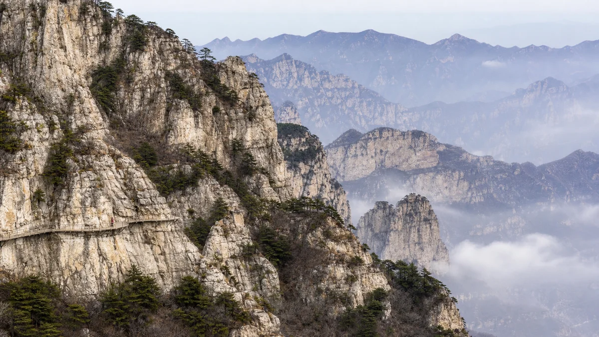
5A View location, maps and nearby scenic areasStop at a safe point along the cliff-side railing and watch the opposite ridge. A pale tower may lose its base to cloud, then disappear. Before calling it a “sea of clouds,” notice the light rock, dark seams, wind-bent trees and a path attached to a much larger slope.
This is Baishi Mountain—Báishí Shān, “White Stone Mountain”—in Laiyuan County at the northern end of the Taihang Mountains. Its name describes pale cliffs, not permanent snow. Carbonate-rock and marble pinnacles stand above deep gullies, then vanish in fast-changing weather.
Orient yourself before choosing a spectacle: use the Baishi Mountain 5A scenic-area profile for the map and coordinates, then use the current scenic-area map to identify your entrance, last return connection and open circuit. The mountain, the managed 5A attraction and the much larger Fangshan UNESCO Global Geopark are three different boundaries.
Read the mountain sideways before looking down
Baishi Mountain’s highest summit, Foguang Ding, is commonly reported at about 2,096 metres above sea level. That is summit elevation, not the drop below a boardwalk or the height of glass above ground. Keeping those measures separate gives a truer scale.
From a side-on viewpoint, trace one pale rib from wooded foot to broken crest. The pinnacles stand in overlapping ranks, divided by clefts and vegetated ledges. A person on a distant walkway gives better scale than a summit number; cloud can erase that measure.
Depth is easiest to read when the air is clear enough to separate those ranks. Compare the colour and contrast of the nearest rib with the washed-out ridges behind it, then watch how the gap changes as you walk. A platform advertised as “higher” does not automatically give the clearest landform view; a lower side angle can explain the peak forest better.
The mountain is part of Fangshan UNESCO Global Geopark, which crosses the Beijing–Hebei boundary. UNESCO gives the entire geopark an area of 104,500 hectares and a geological span exceeding 3.5 billion years. Those are geopark-wide figures, not the size or single age of this ticketed site.
How layered stone became a forest of peaks
Look for two kinds of line. Bedding records layers of carbonate sediment; steeper joints cut across it. The light stone is described as carbonate rock transformed in part into marble, including dolomitic marble. Heat and pressure recrystallised older material; later movement lifted and fractured the northern Taihang block.
Uplift alone did not carve today’s skyline. Water dissolved minerals along cracks; frost, roots and gravity widened weaknesses; blocks detached and gullies deepened. Resistant ribs remained as fins and towers. Dates vary because sedimentation, metamorphism, uplift and erosion are different events—not one “age of Baishi Mountain.”
Tourism language sometimes calls this China’s only marble peak forest. The defensible point is that Baishi Mountain preserves an unusually concentrated, legible example; “only” depends on classification boundaries.
Water, winter ice and rockfall still change the slope. Stay behind barriers even when an unguarded ledge appears to offer the same photograph.
A high ridge also carried human boundaries
Passes connected the North China Plain with upland basins, while ridges served as lookout lines and barriers. UNESCO’s Fangshan account includes the Baishishan Great Wall among the geopark’s cultural sites.
Wall remains need careful reading. Great Wall sections have histories of building, repair and reuse, often discussed through the Ming defence network, but not every trail-side stone line is ancient. Restoration, farm walls and natural rock can look similar. Follow signs; do not climb loose masonry or remove stone.
From a watch position, a ridge becomes a controlled route; from a village below, it was pasture, woodland, water catchment and difficult passage. Soldiers, builders, porters and residents experienced labour and exposure, not simply a panorama.
There is no need to invent a battle for every tower. Steep ridges reduced some construction, narrow gaps concentrated movement and nearby rock supplied material. Geology shaped decisions without determining them.
From working mountain to “geology encyclopedia”
UNESCO calls the wider geopark a “geology encyclopedia.” At Baishi Mountain, one viewpoint can show bedding, joints, vegetation, erosion and engineering together—not a single simple label.
UNESCO also notes Baishishan paper cutting among local traditions. A regional heritage listing does not promise a daily demonstration; at a genuine workshop, ask before photographing people or designs and pay fairly for work you buy.
Roads, cable systems, cliff paths, cleaning, inspection and rescue planning make a difficult ridge accessible and support jobs. They also concentrate footfall, waste and noise. The worker checking a handrail in wind belongs to the mountain’s present history.
Stay on managed paths, carry rubbish to collection points, keep voices low near wildlife and accept closures. The mountain can be economically useful, publicly enjoyable and geologically vulnerable together.
Choose a circuit by legs, light and last connection
Most itineraries use an entrance transfer and, when operating, a cable car to reach the high zone. Maps commonly organise circuits around Xiangyun Gate, Shuangxiong Stone and Feiyunkou, with upper and lower cliff walks. Names, controls and open segments can change, so photograph the day’s map.
For a shorter first visit, choose one viewpoint circuit, pause where pinnacles appear side-on and return well before the last downhill service. This teaches more than sprinting between platforms.
For a longer circuit, link upper and lower walks only if knees, time and weather allow. The lower line makes cliffs feel taller; the upper reveals broader ridge relationships. Connecting them adds many steps even after a cable ascent.
At a junction ask: Is the section open? What return works if a lift stops? How much daylight remains? Hours, tickets, identity-document rules, shuttles and last boarding can change; confirm through the official channel and at the entrance.
Treat cloud, wind and living slopes as route information
Laiyuan’s upland can feel cooler and windier than the city below. Cloud changes rapidly; wet rock and metal steps become slick; sun remains strong in cool air. Carry water, a wind-resistant layer, weather protection and shoes with reliable grip.
Cloud can erase the next ridge and reduce depth perception. Thunder, wind, ice or heavy rain can close cliff sections and aerial transport. If staff turn visitors back, the closure reflects mountain conditions, not a service failure.
Trees occupy nearly soil-free cracks, stabilising some pockets while roots exploit fractures. Do not pull branches, leave the path, feed animals or use calls to draw birds closer.
Cloud is weather, not a performance. Clear air explains ridge structure; mist reveals one pale tower at a time. Let visibility change how you look.
Glass paths and cable cars are tools, not the mountain
Baishi Mountain is known for cliff walks with glass-surfaced sections. Where access is permitted, notice panels, steel support, drainage and inspections. Rules on shoe covers, spacing, photography and stopping may change.
A glass floor reveals the slope but draws attention from the rock face. After crossing, ask what had to be built, inspected and sometimes closed to place visitors here—not only “How high was I?”
Cable cars shorten ascent; they do not make the visit step-free. Ramps may exist, yet queues, transfers, stairs and uneven connectors remain. Travellers with limited mobility, vertigo or heart or respiratory concerns should request current accessibility details and choose an easy retreat.
Do not assume an advertised facility is operating. Wind, lightning, ice, maintenance and crowds can intervene. Build the visit around stone, forest and viewpoints; treat each facility as a conditional aid.
Photograph depth without stepping into danger
Place one dark wooded rib in the foreground and two paler ranks behind it. Side light reveals bedding; a small figure on an authorised walkway gives scale. A moderate focal length often layers peaks better than an ultra-wide lens.
In mist, expose for pale rock and wait for one opening. Keep equipment compact, secure straps in wind and never spread a tripod across a narrow path unless clearly permitted.
On glass, include the cliff edge or support so the image explains its setting. Do not stage jumps, sit on barriers or lean equipment beyond rails. Drone and professional-shoot rules may change; current signs prevail.
Lichen, rain-darkened joints, maintenance hardware and pine across pale rock show an active landscape better than an empty “untouched” mountain.
Leave with the mountain restored to scale
On the way down, find the path you walked. It will vanish into the cliff or shrink to a line. The glass path, cable station and summit number become small interventions on an older structure.
Carbonate sediment became crystalline rock; uplift opened weaknesses; water, cold and gravity turned them into towers. Walls, paths and lifts then used the ridges for defence, livelihood, study and travel.
Tourism brings access and work as well as pressure. Engineered paths can protect slopes while concentrating feet. A balanced visit keeps both sides in view.
For another northern Taihang landscape where geology and human movement meet, continue to Yesanpo. To compare mountain weather with a radically different Hebei ecosystem, follow the water and reed beds at Baiyang Lake.
LoreLens App can help you identify Baishi Mountain’s pinnacles, cliff paths and ridge features on site, then hear how rock, weather and people made the landscape visible.
Location profile
Where it is

Frequently asked questions
What makes Baishi Mountain different from other Taihang Mountains scenery?
Baishi Mountain is noted for a dense landscape of pale carbonate rock and marble pinnacles, sheer walls, narrow gaps and cloud moving between the ridges. Its stone forest belongs to the northern Taihang setting and to the wider Fangshan UNESCO Global Geopark, but the geopark's total area and geological time span should not be mistaken for the dimensions or age of this one scenic area.
How difficult is a visit to Baishi Mountain?
Cable cars and internal transport can reduce the initial ascent when they are operating, but a meaningful visit still involves long cliff-side walks, steps and repeated changes of height. Choose the shorter circuit if you are uncomfortable with exposure, have limited mobility or arrive late, and confirm current route, lift and accessibility information with the scenic area before travelling.
Are the glass walkways and cable cars always open?
No. Glass paths, cable cars, shuttle services and individual trail sections are operating facilities that may close for wind, ice, maintenance, crowd control or other safety reasons. Check the official notice on the day of your visit and plan a satisfying stone-and-landscape route that does not depend on any one facility.
When can I see Baishi Mountain's sea of clouds?
Cloud can gather after changing weather and create dramatic layers around the pinnacles, but visibility, cloud height and timing cannot be guaranteed. A clear day reveals the structure of the ridges more fully, while mist offers a more selective view; either can be rewarding if trails remain safe and open.