Shaanxi · Yan'an
Yellow River Qiankun Bend: Read a River Cut into Loess
Look down on the Yellow River's near-circular turn, learn why an entrenched meander is not explained by one date or legend, and choose safely among Yanchuan's widely separated viewpoints.
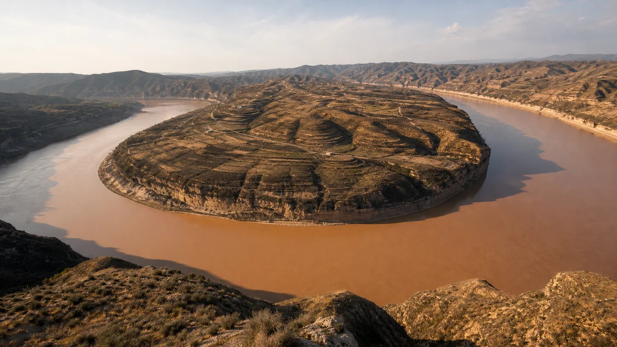
5A View location, maps and nearby scenic areasAt the high viewpoint, find the river twice before trying to photograph it. One reach enters between the yellow-brown ridges; another leaves in almost the opposite direction. Between them, the Yellow River wraps around a high tongue of land until the channel looks nearly closed into a ring. Gullies score the Loess Plateau, villages and fields occupy the more workable surfaces, and the water lies far below.
This is Qiankun Bend in Yanchuan County, part of Yan’an in northern Shaanxi. The great view tempts visitors to explain everything at once: a yin-yang diagram, a sudden geological event, a river “turning back,” or a place where the culture hero Fuxi discovered cosmic order. These are not equivalent claims. The loop is observable landform; its incision requires geological reasoning; “qiankun” is a cultural name; Fuxi belongs to local tradition.
Plan by viewpoint, not by scenic-area label. Qiankun Bend, Qingshui Bend, Huifengzhai and other stops occupy a broad road-linked landscape. Make one river overlook the essential experience, then add a second site only after confirming current distance, gate, shuttle and weather conditions.
Read the loop before reading its name
From above, Qiankun Bend resembles a giant horseshoe whose ends nearly meet. That likeness depends on viewing height and direction. The river remains a continuous channel: it enters the frame, curves around the central ridge and continues downstream. It is not a circular lake, nor does the water literally reverse its overall journey.
Use the central landform to read scale. Its top may carry paths, scrub, terraces or buildings that look tiny from the overlook. The outer banks meet steeper valley walls; inner surfaces can appear broader. Do not assume every visible patch is an active floodplain, because the river is deeply confined below the plateau.
The Yellow River Qiankun Bend 5A profile gives a map position, but a pin cannot show the vertical separation between road, platform and water. Nor can a single photograph prove an exact bend angle: lens choice, crop and viewpoint alter the apparent geometry.
Spend a minute tracing the channel with your eyes. The exercise replaces the tourist symbol with a moving river and makes the next question more useful: how can a looping course survive while cutting such a deep valley?
A free meander and an entrenched meander are not the same
A free meander commonly migrates sideways across a relatively broad alluvial plain. Flow tends to erode the outside of a bend and deposit sediment toward the inside, allowing the loop to shift over time. An entrenched or incised meander keeps a strongly winding plan while the river cuts downward into a rising or lowering landscape.
Qiankun Bend is best understood through the second idea. Its loop is set deep within the plateau rather than wandering freely across a wide modern floodplain. The channel pattern may preserve an inherited course while long-term incision increases relief around it.
That description does not supply one simple cause. River discharge and sediment, the resistance of underlying materials, regional uplift, climate shifts, slope processes and changes in downstream base level can interact. Researchers reconstruct such histories from terraces, sediments, rock relationships and regional dating—not from the resemblance to a symbol.
Avoid precise claims that the bend formed in a particular year, dynasty or single flood unless a named study provides evidence and explains what was dated. “Long-term” is not evasive here; it is more honest than false precision. Even the present landscape is not finished. Banks erode, sediment moves, gullies extend and human engineering changes parts of the watershed.
Loess makes soft-looking slopes with hard consequences
The plateau’s muted yellow surface is dominated by loess, fine wind-deposited sediment accumulated over long periods. It can stand in steep faces when dry, yet it is highly vulnerable to concentrated runoff. Rainwater cutting an unprotected slope can enlarge rills into gullies and carry soil toward tributaries and the Yellow River.
Look for a hierarchy of lines: tiny drainage marks, branching gullies, side valleys and the main river trench. They operate at different scales but are connected. A smooth-looking ridge top may end in a deeply dissected edge, which is one reason leaving a marked path is unsafe even when the ground appears firm.
People have responded through terraces, vegetation recovery, check dams, drainage management and changes in cultivation or grazing. Such measures can reduce erosion locally and help retain soil and water. They also require land, labour, maintenance and decisions about which livelihoods or plant communities receive priority.
Do not turn water-and-soil conservation into a simple story of degraded past and green present. Farming families have adapted to a difficult landscape for generations, while restoration policies can bring benefits and constraints unevenly. The hills visible today combine geology, rainfall, cultivation, abandonment, engineering and ecological management.
“Qiankun” and Fuxi explain meaning, not geology
In the Yijing, or Book of Changes, qian and kun are the trigrams associated with heaven and earth. From a high overlook, the curling water and enclosed ridge invite comparison with yin-yang or bagua diagrams. The name turns an immense landform into a readable cultural image.
Local tourism and oral tradition also connect the bend with Fuxi, the culture hero credited in later Chinese tradition with observing patterns in heaven and earth and formulating the Eight Trigrams. Such stories can express attachment to place and a desire to locate cosmic knowledge in a dramatic landscape.
They are not excavation reports. A resemblance seen from a modern platform cannot prove that Fuxi stood here, nor can a legend date the river incision. Keep the categories visible: geology asks how land and water changed; archaeology asks for material evidence of human activity; tradition asks what a community has chosen to remember and tell.
The categories can still speak to one another. The bend’s form made the story persuasive, while the story taught generations of visitors how to frame the form. Respecting folklore does not require converting it into physical proof.
The river divided provinces and connected neighbours
Along this reach, the Yellow River forms part of the boundary between Shaanxi and Shanxi. From the Shaanxi overlook, the opposite bank belongs to another provincial landscape. Administrative maps treat the channel as a line, but people experienced it as both obstacle and route.
Before modern roads and bridges reorganized movement, ferries and landing places could connect communities, traders and family networks across the water. Boatmen needed knowledge of current, shoals, seasonal level and wind. A safe crossing was skilled work, not the inevitable result of finding a narrow-looking reach.
Villages occupied terraces, tributary mouths and plateau surfaces where water, soil and access made settlement possible. Fields and orchards supported households under conditions of drought, erosion and limited level ground. Paths climbed between river and upland; a short distance on a map could demand a long vertical journey.
Modern conservation, tourism and transport create new opportunities but also costs. Scenic development can provide jobs, roads and markets while changing land use, traffic and the terms on which community life is displayed. Protecting slopes or restricting access can serve public safety and ecology yet constrain grazing, cultivation or familiar routes. The panorama includes residents, not empty scenery.
One scenic area contains several distant chapters
Qiankun Bend is the signature overlook, but the managed destination is not one compact park. Qingshui Bend offers another river turn and a different relation between channel and plateau. Its name should not be read as a promise that the water will appear clear; suspended sediment, light and flow conditions vary.
Huifengzhai adds a cliff-top defensive and settlement landscape. Surviving, repaired and reconstructed elements may stand together, so use current labels before assigning every wall or room one age. Its position is the most reliable first fact: height and restricted approach made observation and defence possible, while residents still needed water, food and paths.
Other village, cultural and river stops may appear on scenic maps or ticket packages. Road distance between them matters more than graphic proximity. A transfer can involve winding plateau roads, controlled gates and waiting time.
Do not build a day around a shuttle, boat trip or performance until current operation is confirmed. Weather, water conditions, maintenance, demand and seasonal programming can alter each. A boat-level view, when available, cannot replace the high panorama; it answers a different question about cliff height and current.
Choose a route by the question you want answered
For a landform-first visit, give Qiankun Bend your clearest attention and add Qingshui Bend only if transfers are straightforward. Compare how much of each loop is visible, where tributary valleys enter and how the plateau surface relates to the water.
For a community-and-defence route, pair one overlook with Huifengzhai or an interpreted village stop. Read building labels, restored surfaces and local accounts rather than treating every old-looking wall as timeless. Buy from local businesses without turning residents or doorways into unasked-for portrait sets.
For a short or mobility-conscious visit, choose the main platform with the least transfer and the most reliable accessible route. One complete view with rest is better than several rushed stops reached by stairs and long drives. Confirm the distance from parking or shuttle drop-off, step-free access and available toilets.
Save the return gate, vehicle location and accommodation name in Chinese. Mobile coverage and wayfinding can vary in a large rural landscape. Treat published journey times as estimates, and keep enough margin that one closure does not force unsafe speed on winding roads.
Water colour, sunset and the perfect photograph are conditional
The Yellow River is not one permanent shade of yellow. Suspended sediment, upstream rainfall, seasonal flow, regulation, sky reflection and viewing angle can make the water look ochre, brown, green-grey or silver. A clearer-looking day does not mean the river has changed identity, and muddy water alone cannot diagnose one local erosion event.
For the complete bend, a moderate wide lens or carefully stitched panorama often preserves more scale than an extreme wide angle that pushes the river into the distance. Include a foreground ridge, railing-safe human figure or field pattern to explain height. A longer lens can isolate terraces, boats or the narrow neck of land, but it may flatten separation.
Sunset can bring warm light to loess ridges, yet valley walls also cast early shadow. Fog or haze may erase the far channel; cloud can soften relief; strong wind can shake a tripod. Arrive with time for changing light instead of promising one perfect minute.
Follow current rules for drones and tripods. Never place equipment beyond a barrier, ask another visitor to stand near an edge, or block a narrow platform. A photograph that hides the guardrail is not worth making the landscape less safe.
The vertical landscape sets the safety and access rules
At the overlook, the river’s distance below can make the edge feel abstract. It is not. Loess and weathered rock can fail, wind gusts can shift balance, and loose gravel can roll underfoot. Stay behind barriers, keep children close and do not step onto an unofficial spur because earlier photographs show someone there.
Rain, ice, fog and high wind change more than image quality. Paths become slippery, visibility shrinks and transport can be restricted. Obey closures even if the main platform looks calm; conditions on an exposed road or stairway may differ.
Accessibility is uneven across this multi-site destination. Some principal viewpoints may have paved approaches, ramps or vehicle drop-offs, while cliff paths, towers and older village surfaces retain steps, slopes and rough paving. A shuttle does not guarantee a step-free final approach. Confirm current arrangements with the operator before travel.
Visitors with limited stamina should plan one panorama, shade and seating rather than measuring success by the number of site names reached. Carry permitted water and sun protection, but keep hands free on stairs. Long road transfers can also be tiring; the shortest route is often the more revealing one.
Let the river continue beyond the frame
Tang poet Li Bai wrote, “Do you not see the Yellow River’s waters come from heaven, rushing to the sea, never to return?” The line opens his poem Bring in the Wine. It was not written as a description of Qiankun Bend, and “from heaven” is poetic scale rather than hydrology.
Its story nevertheless fits the viewpoint in an unexpected way. Li Bai compressed the river into irresistible forward motion; here, the water seems to turn back on itself before continuing downstream. The bend does not disprove the poem. It makes visible how a continental journey can contain delay, curvature and deep work.
The verse remains recited in schools and public culture, helping the Yellow River carry ideas of time, energy and national memory. Qiankun Bend adds a modern echo: the river is also a managed watershed, a provincial boundary, a home landscape and an ecological responsibility.
Before leaving, trace the entering and departing reaches once more. The loop becomes less like a closed symbol and more like a process that exceeds the frame. Continue to Hukou Waterfall for another encounter with channel confinement, the Yan’an Revolutionary Sites for the plateau’s twentieth-century political history, or the Mausoleum of the Yellow Emperor for a different meeting of landscape, cultural ancestry and living ceremony.
Location profile
Where it is

Frequently asked questions
How did the Yellow River form the near-circular Qiankun Bend?
The visible loop is an entrenched meander shaped by long-term river incision into the plateau. Its development reflects interacting controls such as inherited river course, rock and sediment, discharge, regional uplift, climate and downstream base level. A precise formation date or one-event explanation is not justified by the view alone.
Does the name Qiankun Bend prove that Fuxi created the Eight Trigrams here?
No. Qian and kun are culturally powerful terms associated with heaven and earth in the Chinese classic Yijing, and local tradition connects the landscape with Fuxi observing the heavens. These stories explain how people interpret and name the bend; they are not geological or archaeological evidence for how or when the valley formed.
Can I see Qiankun Bend, Qingshui Bend and Huifengzhai in one visit?
Possibly, but the scenic area contains separated sites linked by road, and a map can understate the transfer time. Choose one primary panorama and one secondary stop unless current transport is confirmed. Shuttle routes, boat trips, gate access and last departures can change.
Is sunset the best guaranteed time to photograph Qiankun Bend?
There is no guaranteed best light. Cloud, haze, fog, wind, seasonal vegetation, water level and suspended sediment alter the view, while sunset can place parts of the gorge in shadow. Allow more than one viewing window if photography matters and never cross a barrier to improve the angle.
Sources and further reading
Background references for the history and place names in this guide. Opening hours, ticketing and access change often — always confirm with official local information before travelling.