Shaanxi · Yan'an / Shanxi · Linfen
Hukou Waterfall: Where the Yellow River Narrows
Watch the Yellow River contract from a broad channel into a bedrock slot, compare the Shaanxi and Shanxi banks, and understand how sediment, season and safety controls reshape every Hukou visit.
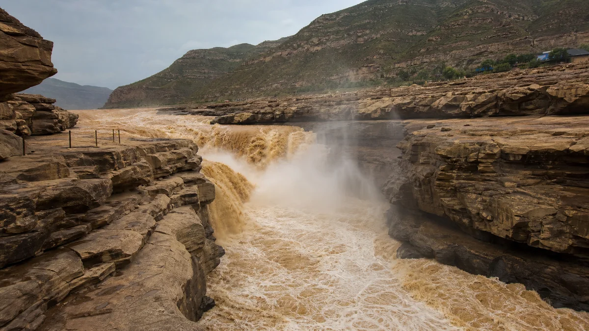
5A View location, maps and nearby scenic areasListen before you look over the rail. The first impression of Hukou Waterfall is not a clean white curtain but a low, continuous concussion. Upstream, the Yellow River still occupies a broad rock channel. Then its muddy flow crowds toward a narrow trench, folds over itself and disappears into spray. The river seems to have lost a floor.
Now look across the water. The people on the opposite bank are not in another section of the same entrance. One bank belongs to Shaanxi, in the Yan’an area; the other belongs to Shanxi, in the Linfen area. Hukou is a shared scenic area on a provincial boundary, approached and managed from both sides. Any guide that describes it as belonging only to Shaanxi—or only to Shanxi—has erased half the landscape.
Read Hukou in three movements: follow the broad upstream surface as it begins to accelerate; find the point where the channel contracts and drops; then trace the narrow bedrock trough downstream. The visible width, fall, color and viewing access all change with water level, so use the landforms—not one fixed number—as your map.
One waterfall, two provinces and two entrances
The Yellow River is the boundary through this part of the Jin–Shaan Gorge: “Jin” is the traditional short name for Shanxi, while “Shaan” identifies Shaanxi. The Shaanxi approach is associated with Yichuan County under Yan’an; the Shanxi approach is associated with Jixian County under Linfen. Together, the two bank areas make up the nationally recognized Hukou tourism landscape.
They are not linked by a footbridge at the falls. Each has its own road arrival, ticketing, parking or transfer arrangements, walking surfaces and staff. A ticket, shuttle or reservation for one side should not be assumed valid on the other. To change banks, visitors normally need a road detour and an appropriate river crossing well away from the cascade; the time required depends on traffic and current routes.
The shared status matters culturally as well as practically. Both banks have communities, performance traditions, guides and visual claims on the river. The waterfall is not a border object that one province owns and the other merely watches. The river makes the boundary, while the sound, spray and geological process belong to the same channel.
For most itineraries, choose the bank that fits the journey before and after Hukou. Travellers coming through northern Shaanxi may combine it with the Yellow Emperor Mausoleum or Yan’an Revolutionary Sites. Those approaching from southern Shanxi may have a different road logic. Attempt both only if the distinct views justify the extra transport.
A broad river forced into a slot
Hukou is often described through a dramatic pair of numbers: a river hundreds of metres wide upstream narrowing to only a few dozen metres, then falling roughly 15–20 metres. These are useful orders of magnitude, not permanent dimensions. “Width” may mean the wet surface, the active chute or the wider bedrock channel; “height” depends on which ledge and downstream water surface are measured. Both change with stage.
The physical principle is clearer than a precise figure. The Yellow River crosses a relatively broad rocky bed, then encounters a resistant, confined channel. Water is funnelled toward a narrow trough, velocity increases and the flow plunges and churns through an irregular series of ledges rather than one engineered straight lip. During high water, separate tongues can merge into a broad, chaotic front. At lower water, more bedrock appears and individual channels become legible.
Downstream, the river continues in a narrow incision commonly called a dragon trough. Turbulence, sediment-loaded abrasion, block failure and repeated flood forces work on the rock. Over long periods the waterfall zone has migrated as erosion removes material, although a single neat retreat rate would oversimplify different ledges and survey periods.
Use stationary rock and people on the opposite bank for scale. The river’s force appears in failing patterns: a whirlpool that looks stable is gone seconds later.
Why the Yellow River is yellow—and not always the same yellow
Much of Hukou’s ochre and brown color comes from fine sediment carried through the Loess Plateau. Loess is easily eroded silt deposited across northern China over long geological time. Rainfall and runoff can deliver suspended material to tributaries and the main river, making the water look less transparent and giving the spray a muddy cast.
Sediment is not constant. Rain location, season, tributary input, upstream reservoirs, water releases, soil-and-water conservation and flood management all affect concentration and discharge. A photograph of dense brown water is not a guaranteed daily appearance, and clearer-looking water does not mean the Yellow River has ceased carrying sediment.
Historically, sediment built and reshaped channels downstream, supported some floodplain fertility and contributed to severe flood risk when deposition raised riverbeds. Modern erosion-control planting, terraces, check dams and reservoir operations have reduced or redistributed sediment in complex ways. No single dam or policy explains every change at Hukou.
This is why flow and sediment numbers need a date and measuring station. A peak flood measurement is not an annual norm; a low-water photograph does not establish the waterfall’s permanent width. Visitors do not need a live hydrology table to appreciate Hukou, but they should resist turning one spectacular day into a fixed natural specification.
A “kettle mouth,” a Dragon Cave and several viewing levels
The name Hukou (pronounced roughly “hoo-koh”) means “kettle mouth.” It describes the visual idea of a broad river being gathered into an opening narrow enough to resemble water pouring through the mouth of a huge vessel. It is a landscape metaphor, not a claim that the rock forms a perfectly circular kettle.
The main upper viewpoints let you see the contraction and the broken waterfall front. Lower positions, when open, change the experience: the horizon rises, the roar becomes more physical and spray can obscure the opposite bank. A low platform is not automatically the best view; it can trade overall geometry for proximity and may close first when water or ice makes access unsafe.
On the Shanxi side, the feature commonly marketed as Longdong, or “Dragon Cave,” can offer a lower, side-on encounter when operating. It is a visitor access feature associated with the bank’s rock space, not the source of the name Hukou and not a guaranteed part of every ticket or day. Steps, confined surfaces, water level, maintenance and safety controls may affect entry.
The two banks also produce different sightlines. Shaanxi’s open rock apron can give a broad diagonal or frontal reading; Shanxi can place you closer to the side of the fall and the lower cave experience. Yet changing channels can move the strongest curtain toward or away from either side. Ask what is open today rather than accepting an eternal verdict about the “better” bank.
Li Bai’s river came “from heaven”—in poetry
The most famous line brought to Hukou is by the Tang poet Li Bai: “Do you not see the Yellow River’s waters come from heaven, rushing to the sea, never to return?” It opens his poem Bring in the Wine with a scale larger than ordinary life.
Li Bai was not writing a hydrological description of Hukou, and the poem should not be presented as if composed at this railing. “From heaven” turns the distant highlands and overwhelming river into an image of time: water races away as human youth and opportunity do. The poem moves from cosmic scenery to a defiant demand to live intensely despite impermanence.
That cause, turn and consequence explain why the quotation works here. The river’s apparent arrival from beyond the canyon becomes a measure of life’s momentum; recognition that it will not return leads the poet toward celebration shadowed by loss. Hukou supplies a physical sound for an idea that the poem already carried.
Its modern echo is everywhere in Chinese education, recitation, song, calligraphy and Yellow River tourism. Many visitors know the line before they know this geology. Keep both meanings: the verse helps express emotional magnitude, while actual water comes through a measurable basin shaped by climate, tributaries and infrastructure. Literature can deepen observation without becoming a flow gauge.
Boatmen, river communities and the cost of passage
For people moving along the Yellow River, Hukou was not simply a viewpoint. The constriction interrupted navigation. Historical and local accounts describe cargo being unloaded and boats moved or portaged around dangerous reaches when conditions allowed, with people and animals supplying force on land. Methods varied by period, vessel, bank and water level; this was labor, not a picturesque stunt.
Boatmen read currents, wind, exposed rock and sound because errors could be fatal. Their knowledge belonged to wider river communities of ferrymen, farmers, traders and settlements connected to seasonal transport. Folk songs and boatmen’s calls preserved the rhythm of collective work, although not every “Yellow River boatmen’s song” heard at a modern performance originated at Hukou itself.
Roads, bridges, reservoirs and modern regulation changed those livelihoods. Tourism created work in transport, guiding, hospitality, performance and photography, while also bringing congestion, commercial pressure and exposure to fluctuating visitor seasons. Communities on both banks live with a national icon as an everyday workplace.
Flood control and soil conservation likewise involve trade-offs. Upstream storage and release can reduce some risks or serve water and power needs, yet operations interact with natural rainfall and tributary floods. Erosion-control projects can retain soil, while river ecosystems respond to altered sediment and timing. Hukou should not be used as a simple poster either for untouched nature or total human control.
Choose a bank by route, access and the view you value
Choose Shaanxi if it fits a Yan’an or northern Shaanxi circuit and you value an open, broad reading of the fall. Choose Shanxi if your road itinerary lies east of the river or the close side view and possible Dragon Cave access matter more. These are tendencies, not promises; water position and closures can change the result.
On either bank, begin upstream enough to understand the broad channel, then move toward the contraction and finally look downstream into the trough. If you start only at the loudest rail, the waterfall appears as chaos. Following the sequence reveals why the chaos occurs.
Internal buses, walking distances, low platforms, cave access and last-entry rules are dynamic. Confirm them with the official operator for the specific province you intend to visit. Search results can easily surface the other bank’s map or ticket page, so check place names—Yichuan/Yan’an for Shaanxi, Jixian/Linfen for Shanxi—before paying.
Trying both sides in one day adds a road transfer rather than a quick bridge walk. It can be worthwhile for researchers, photographers or repeat visitors, but a first-time traveller may gain more by watching one bank carefully. If you want another view of the river’s geometry without duplicating Hukou, the Yellow River Qiankun Bend turns the question from vertical force to vast horizontal curvature.
Flood, ice, rainbow and performance are never guaranteed
Hukou’s seasonal labels can sound like a booking menu: spring ice, flood-season thunder, autumn volume, winter ice forms. In reality, temperature, rainfall, upstream inflow and operational safety determine what appears. A major flood may make the waterfall enormous while closing the very low platforms promoted in older photographs.
Ice can build shelves, pillars or frozen spray under suitable winter conditions. It can also create falling hazards, block roads and prompt closures. Never walk onto river ice or cross a barrier because another visitor did. Ice jams and moving floes are dynamic hazards, not a static sculpture garden.
A rainbow needs airborne droplets, direct sunlight and the correct viewing angle. Heavy spray alone is insufficient; cloud, sun position and wind can remove it within seconds. Lighting displays, folk performances or other programmed attractions also depend on schedule, weather, maintenance and ticket conditions. Check locally and treat any appearance as a bonus.
The edge environment deserves respect even in ordinary flow. Noise can mask warnings and conversation. Spray makes stone slick, wind can unbalance loose items, and wet sediment stains clothing and equipment. Keep children close, stay behind rails, do not climb onto the apron and leave immediately if staff restrict an area.
Protect the lens, respect the edge and leave with the sound
For a wide photograph, include the broad upstream river and the point of contraction so the image explains the waterfall rather than showing only brown foam. A moderate telephoto can isolate folds of water or people on the other bank for scale. Fast shutter speeds freeze sediment-laden forms; slower speeds show motion but require support that must not obstruct a path.
Carry a lens cloth, simple rain cover and secure strap. Spray can reach farther than expected, while muddy droplets are harder to clean than mist. Drones, tripods and commercial equipment may be restricted; follow current rules. Do not extend a phone or selfie stick beyond barriers, and never step onto wet rock for an unobstructed frame.
Main viewing areas may have paved access, internal transport or ramps, but lower platforms, stairs and the Dragon Cave can be much less accessible. Operations differ between banks. Visitors needing step-free travel should ask the chosen operator about the route from vehicle drop-off to an active viewpoint, accessible toilets and whether spray or ice has closed the safest level.
Before leaving, stop filming and listen again. At first the roar seems to announce a river too powerful for human influence. After reading the sediment, portage stories, flood controls and two provincial systems, the sound becomes more complicated. Hukou is wild energy channelled by rock, weather, history and modern management.
The name “kettle mouth” makes the river small enough to imagine in the hand. The actual experience does the opposite. One channel binds two provinces, carries the labor and engineering of communities upstream and down, and changes while you watch. The most honest souvenir is not a promised rainbow or fixed width, but the moment a broad river disappears into a narrow sound.
The LoreLens app can help identify the channel, rock trough and viewing features, then connect what you see to Yellow River geology, poetry and working communities.
Location profile
Where it is

Frequently asked questions
Is Hukou Waterfall in Shaanxi or Shanxi?
It is shared by both. The Yellow River forms the provincial boundary here, with a Shaanxi scenic-area entrance in the Yan'an direction and a Shanxi entrance in the Linfen direction. They face the same waterfall from opposite banks but have separate road approaches, visitor facilities and operating arrangements.
Which bank is better for a first visit?
Neither bank is always better. Shaanxi commonly offers broad oblique or frontal views from an open rock apron, while Shanxi can offer close side views and, when operating, access toward the lower Dragon Cave viewpoint. Water level, spray, sunlight and safety closures can reverse the advantage. Choose by your route and confirm current viewpoints rather than crossing provinces for one promised photograph.
Can one ticket be used on both sides of Hukou Waterfall?
Do not assume so. The two scenic areas normally operate through separate provincial entrances, tickets and internal transport, and there is no pedestrian crossing over the waterfall. Visiting both can require a substantial road detour. Check each side's official ticket terms and road conditions before planning a two-bank day.
When is the best time to see a flood, rainbow or ice at Hukou?
None can be guaranteed. High water depends on rainfall and river operations and may close low viewpoints; rainbows require spray, sun and the right angle; ice forms under suitable winter temperatures but can also restrict access. Choose a season for your broader itinerary, then check weather, flow alerts and the current open areas shortly before travel.